


























Quick Field Data
- UNESCO Inscription: 1987 · Criterion (viii).
- Scale & Footprint: 88,000 ha original World Heritage inscription (expanded by 47,000 ha in 2004; total national park 354,461 acres or 1,434.45 square kilometres) on the island of Hawaii.
- Access & Ticketing: Administered by the National Park Service; check the official site for current entrance pass rules, volcanic hazard advisories, and road closures.
- Arrival Logistics: Reached via the Hawaii Belt Road (Highway 11) southwest of Hilo; travellers frequently combine island-hopping itineraries with Maui.
Shield Volcanism from Sea Floor to Summit
Included on the UNESCO World Heritage Atlas in 1987 under Criterion (viii) after being designated an International Biosphere Reserve in 1980, Hawaiʻi Volcanoes National Park encompasses two of the most active and accessible volcanoes on the planet: Kīlauea (rising to 1,250 metres) and Mauna Loa (reaching 4,169 to 4,170 metres, or 13,679 feet). Volcanism shapes every ridge here. Situated in Hawaii County on the island of Hawaiʻi inside the state of Hawaii, the park climbs continuously from the black-sand shores of the Pacific Ocean to the summit caldera of Mokuaweoweo atop Mauna Loa. Measured from its submarine base on the ocean floor, Mauna Loa is the greatest volcanic mass on earth, while neighbouring Kīlauea (whose Hawaiian name means "much spreading" in reference to its frequent lava flows, whereas Mauna Loa means "long mountain") offers an unmatched outdoor laboratory for observing shield-building volcanism.
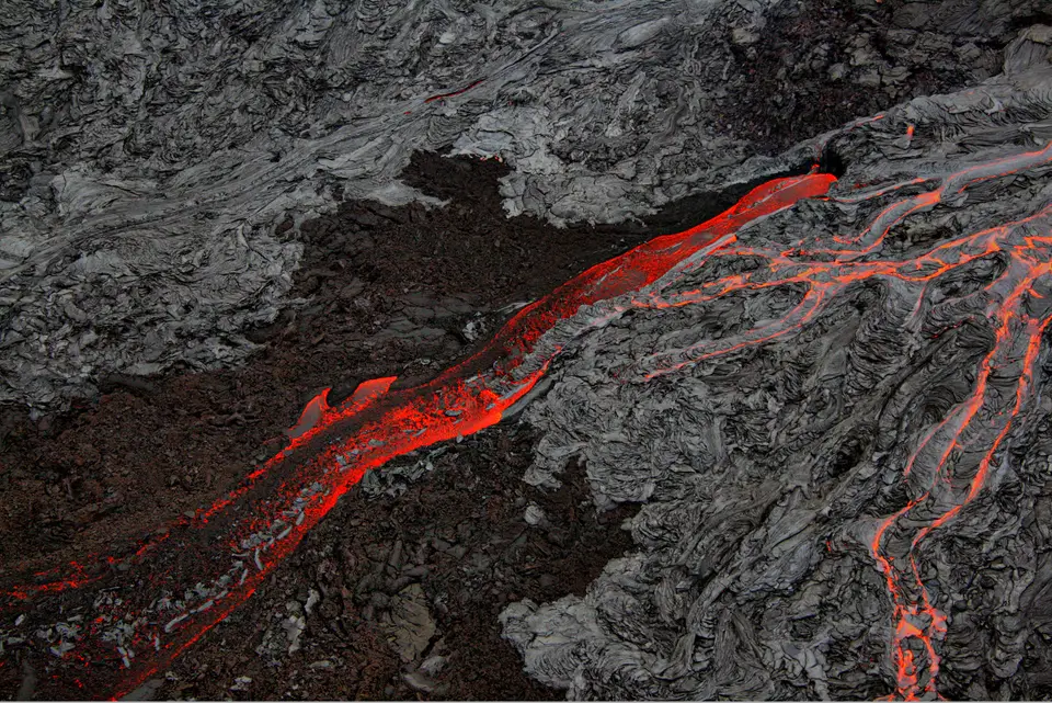
Fluid basaltic lava erupts here to create a constantly changing landscape, cooling into smooth, ropy pāhoehoe surfaces and rough, jagged ʻaʻā flows that continually reshape the island's topography and coastline. Visitors who explore the Hawaiian Archipelago, often pairing the island of Hawaiʻi with Maui (whose Haleakalā National Park was originally joined with this park as Hawaii National Park from 1 August 1916 until their formal split on 22 September 1961), witness the youngest, most dynamic stage in the geological origin of the islands. Originally inscribed at nearly 88,000 hectares (of which 73% received wilderness protection under the 1964 Wilderness Act, with 130,790 acres or 529 square kilometres formally designated as the Hawaii Volcanoes Wilderness in 1978), the park now spans 354,461 acres (553.85 square miles, or 1,434.45 square kilometres) and welcomed 1,433,593 recreation visits in 2024. In 2012, the park was also depicted on the 14th coin of the America the Beautiful Quarters series.
Western accounts of the erupting crater began in 1823 when English missionary William Ellis and American missionary Asa Thurston reached Kīlauea, and during the 1840s hoteliers Benjamin Pitman and George Lycurgus ran rim-side lodges, succeeded by the 1877 Volcano House (now housing the Volcano Art Center and remaining the only hotel or restaurant inside the park boundaries). In 1903, William R. Castle proposed protecting the volcanoes, and Asa Thurston's grandson Lorrin A. Thurston (who invested in Volcano House from 1891 to 1904 and owned The Honolulu Advertiser) championed the park alongside landowner William Herbert Shipman and Governor Walter F. Frear, hosting fifty members of Congress for a steam-vent dinner in 1907, entertaining Secretary of the Interior James Rudolph Garfield in 1908, and printing statements supporting the park from John Muir alongside Henry Cabot Lodge and Theodore Roosevelt. Delegate Jonah Kūhiō Kalanianaʻole introduced House Resolution 9525, signed by President Woodrow Wilson on 1 August 1916 to create the eleventh national park in the country and the first in a territory, weeks before the National Park Service was established under the Organic Act. Between 1915 and 1917, six companies from the 25th Infantry Regiment (the Buffalo Soldiers) travelled from Schofield Barracks using 12-pound hammers and gunny sacks in cold, rainy weather to build a 30-mile mountain trail linking Kīlauea with Mauna Loa alongside the Kilauea Military Camp and the Hawaiian Volcano Observatory before the park formally opened in 1921.
Eruptive Milestones and Changing Calderas
Major volcanic events have repeatedly reshaped the park. In 1790, an unusually violent eruption caught a party of Hawaiian warriors, women, and children in the Kaʻū Desert, leaving behind the preserved 1790 Footprints in solidified volcanic ash. A hydrothermal explosion at Halemaʻumaʻu in 1924 remained the last explosive event in the caldera until 19 March 2008 (which was also the first eruption inside Kīlauea caldera since September 1982), when a gas-driven blast scattered debris across 74 acres (30 hectares), damaged the Halemaʻumaʻu Overlook, and emitted heavy sulfur dioxide plumes that closed sections of Crater Rim Drive alongside the Crater Rim Trail south of Kīlauea Military Camp, Byron Ledge, the ʻIliahi (Sandalwood) Trail, and the Kaʻū Desert Trail. Meanwhile, along the East Rift Zone, the remote vent of Puʻu ʻŌʻō erupted for decades, sending lava flows across the coastal section of Chain of Craters Road near the town of Kalapana so that the buried highway functions only as an emergency evacuation route.
On 11 May 2018, explosive eruptions, toxic ash clouds from Halemaʻumaʻu, road fractures, and some 60,000 recorded earthquakes forced a closure of the Kīlauea summit district (while the Kahuku District remained open) until 22 September 2018. Ground collapses and explosions ended in early August 2018, reducing sulfur dioxide emissions below late 2007 levels, but leaving the Thomas A. Jaggar Museum (named after scientist Thomas Jaggar, first director of the U.S. Geological Survey's Hawaiian Volcano Observatory) and adjacent observatory buildings so severely damaged that they were torn down in 2024. The Thurston Lava Tube (Nāhuku), which includes a developed public tunnel plus an undeveloped 1,100-foot (340-metre) section dead-ending into the hillside, reopened on 21 February 2020 after rockfall clearing and sensor installation. In summer 2019, a water pond appeared inside Halemaʻumaʻu and deepened to 160 feet (49 metres) by 1 December 2020 before a new eruption on 20 December 2020 boiled the lake away and refilled the crater floor with lava, followed in 2022 by an eruption of Mauna Loa after 40 years of inactivity.
Kanaka Maoli Heritage, Kahuku, and Pōhue Bay
For the indigenous Kanaka Maoli (Native Hawaiians), Kīlauea and its Halemaʻumaʻu crater are revered as the sacred home of Pele, goddess of fire, lightning, wind, and volcanoes. Living sustainably by the ethical principle of pono (leaving natural lava rocks undisturbed in their rightful place), Kanaka Maoli view each eruption as a demonstration of sacredness in which the Earth is reborn. Interpretive rangers share ceremonial history, language, and traditional Hawaiian items including the kākoʻi adze for hollowing canoes, wooden kiʻi god statues, cooked taro poi, ti-leaf lei lāʻī adornments for hula, and ipu heke ʻole gourd drums. In 2003, the Volcano Art Center held a competition judged by Native Hawaiian elders who selected Arthur Johnsen's painting of a Polynesian Pele holding an ʻōʻō digging stick in one hand and the egg of her sister Hiʻiaka in the other from 140 entries, replacing D. Howard Hitchcock's 1929 oil painting (donated by his son Harvey in 1966) in 2005.
Land acquisitions have expanded the park's ecological reach from lush giant-fern rainforests and the Olaa Forest to the arid Kaʻū Desert. In 2003 and 2004, the park grew by 56% through the addition of the 115,788-acre (468.58-square-kilometre, or 47,000-hectare) Kahuku Ranch tract acquired from the Samuel Mills Damon estate with support from The Nature Conservancy, reached via Kahuku Road turning off Highway 11 close to mile marker 70 between Waiʻōhinu and Ocean View. In August 2018, nearly 2,000 acres (810 hectares) were purchased near the Great Crack, an 8-mile-long (13,000-metre), 60-foot-wide (18-metre), and 60-foot-deep fissure resulting from crustal dilation along the southwest rift zone where lava welled from its lower 6 miles (10 kilometres) in 1823 (unaffected by the 1868 and 1975 earthquakes) alongside twelfth-century archaeological sites. Finally, in 2022, 16,451 acres (6,657 hectares) at Pōhue Bay were transferred to the park by The Trust for Public Land, protecting the Ala Kahakai National Historic Trail (Ala Loa), Hawaii's largest abrader quarry, mauka-makai trails, fishing shrines, petroglyphs, anchialine ponds with endemic opaeʻula red shrimp, and coastal habitats for the Hawaiian hawksbill turtle (honuʻea), the Hawaiian monk seal, the great frigatebird (ʻiwa), the white-tailed tropicbird (koaʻe kea), the Pacific golden plover (kōlea), the wandering tattler (ʻulili), and the black-crowned night heron (ʻaukuʻu).
- Crater Rim & Chain of Craters: Enter off the Hawaii Belt Road to explore the Halemaʻumaʻu caldera overlooks, Devastation Trail, Kīlauea Iki, Thurston Lava Tube (Nāhuku), Hilina Pali Road, and Chain of Craters Road toward Holei Sea Arch and Kamoamoa.
- Historic Places & Buffalo Soldier Trails: Discover National Register landmarks including the 1877 Volcano House, the 1790 Footprints, Ainahou Ranch, Ainapo Trail, Puna-Kāʻu Historic District, Wilkes Campsite, Whitney Seismograph Vault No. 29, Namakani Paio Campground, and the 30-mile Mauna Loa trail.
- Kahuku & Pōhue Bay: Visit the high pastures of the Kahuku District turning off Highway 11 close to mile marker 70 and the coastal lava tubes, petroglyphs, and turtle beaches of Pōhue Bay.
