Quick Field Data
- UNESCO Inscription: 2019 (Ref. 1588), serial cultural landscape in Mandalay Region, Myanmar; Criteria (iii) and (iv).
- Scale & Footprint: 5,005.49 hectares across seven or eight protected components (holding 2,229 to 2,300 standing temples inside 3,595 recorded archaeological monuments), surrounded by a 100-kilometre by 100-kilometre buffer zone.
- Access & Ticketing: Administered by the Department of Archaeology and National Museum (DANM) under Law 20/2019; check official local desks for zone entry passes and earthquake temple closures.
- Arrival Logistics: Major commercial flights arrive at Mandalay International Airport (MDL), 128 kilometres northeast. Regional cross-border hubs sit farther away toward Chiang Mai (501 kilometres southeast).
Pagan Empire Origins and Bagan Myanmar History Across the Plain
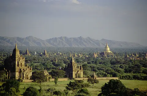
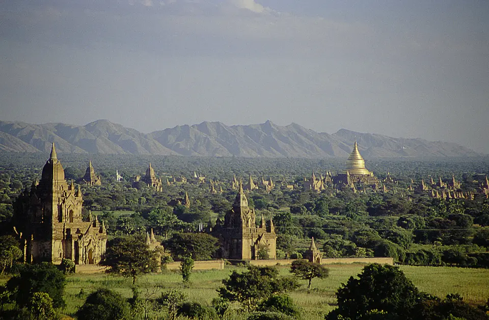
Spreading across a broad bend of the Ayeyarwady River in Myanmar's central dry zone, Bagan preserves the brick architectural centre of the first kingdom to unify the nation's historic regions. Burmese chronicles date early settlement to the second century CE and credit King Pyinbya, 34th successor to the early founder, with fortifying the town in 849. Western scholarship assigns urban foundation to the mid-to-late ninth century, when Mranma (Burman) groups descending from the Nanzhao Kingdom settled the Irrawaddy valley among competing Pyu city-states before rising to regional supremacy late in the tenth century.
Classical Pali inscriptions record multiple names for the royal capital, headed by Arimaddanapura, translated literally as the city that tramples on enemies. Dry-zone epithets including Tattadesa (parched land) and Tampadipa (bronzed country), together with Thiri Pyissaya and Tampawaddy, describe its sun-baked central basin. From 1044 until 1287, Bagan operated as the political, economic and cultural nerve centre of the Bagan Empire. Across 104 square kilometres (40 square miles) of flat plain, monarchs and wealthy subjects erected more than 10,000 religious structures, encompassing roughly 1,000 stupas, 10,000 small temples and 3,000 monasteries.
Inside a cosmopolitan city home to 50,000 to 200,000 inhabitants, redistributional Kammatic Buddhism bound spiritual merit directly to political control. Acting as chief royal donor, the king harnessed river transport and agricultural estates to consolidate regional influence. While royal patronage from the mid-11th century elevated Theravada Buddhism to primacy, daily religious practice stayed unusually fluid and syncretic. Mahayana and Tantric Buddhism coexisted openly with Saivite and Vaishnava Hindu traditions and indigenous nat spirit worship.
Intellectual life drew monks and lay scholars from India, Sri Lanka and the Khmer Empire into thriving monastic libraries. Centres of study specialised in Pali grammar and abhidhamma psychological philosophy while teaching secular and sacred treatises in multiple languages covering prosody, phonology, astrology, alchemy, medicine and legal studies. This scholarly output cemented Bagan's prestige across mainland Southeast Asia long before European fleets entered regional waters.
Sustained monument building reshaped regional labour markets across both town and countryside for over 250 years. Constructing thousands of brick complexes stimulated brickmaking, masonry, goldsmithing, silversmithing, bronze casting, carpentry, woodcarving and ceramics, while finished temples continually employed artisans and labourers for upkeep. Accountants, bankers and scribes managed temple endowments, paying skilled workers generously and attracting migrants of diverse linguistic backgrounds from declining neighbouring polities such as Dvaravati, Srivijaya and the Chola Empire.
Imperial power fractured around 1287 amid repeated Mongol incursions spanning 1277 to 1301, though recent historical scholarship alters the old narrative of violent sackings. Rather than Mongol armies demolishing the plain directly, historian Michael Aung-Thwin argues that frontier provincial governors defending against northern raids rose into a new ruling elite. Bagan slowly faded into a quiet regional town of modest size, formally losing capital status to the Myinsaing Kingdom in December 1297.
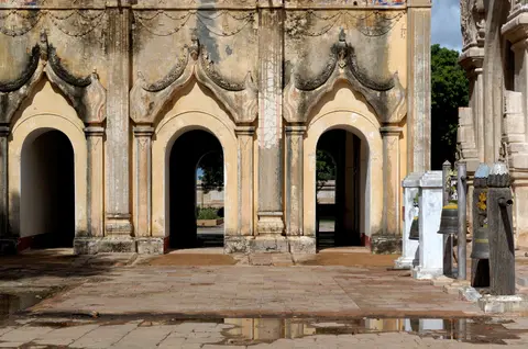
Cruciform Brick Vaults, Merits, and Three Monument Clusters
Examining monument distribution across the 5,005.49-hectare zone reveals three distinct construction waves organised across seven or eight protected components, with seven sectors east of the Ayeyarwady and one sector across the river. By the late 11th century, a nine-kilometre ceremonial corridor stretched north to south along the east bank around the walled urban core of Old Bagan. Scattered 11th-century temples spread across the whole strip suggest decentralised village-level foundations encouraged by Old Bagan elites.
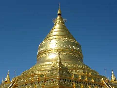
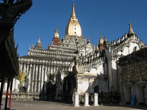
Monumental scale and building material volume peaked between 1150 and 1200, when Bagan's grandest brick temples reshaped the plain. Revered Ananda Temple illustrates cruciform planning around four towering Buddhas, concentric vaulted ambulatories and gilded sikhara spires, while 12th-century Thatbyinnyu Temple lifts whitewashed brick terraces high above surrounding trees. Northward near Nyaung-U stands gilded Shwezigon Pagoda, anchoring one end of the pilgrim road near Sulamani, Htilominlo and Dhammayazika temples. Building also extended eastward away from the Irrawaddy during this late-12th-century surge.
By the 13th century, dense shrines packed Old Bagan, shifting new foundations east into monastic districts like Minnanthu sited equally close to the original nine-kilometre river strip. Construction pivoted sharply toward monastic complexes ringed by compact smaller stupas and chapels. Archaeologists Bob Hudson, Nyein Lwin and Win Maung argue that private village donors gained broader access to individual merit-making, whereas Aung-Thwin links smaller footprints to dwindling economic resources and expanding monastic control. Today, between 2,229 and 2,300 standing brick temples survive within 3,595 recorded monuments, rich in inscriptions, sculptures, murals and cloth paintings sustained by active worship and farming.
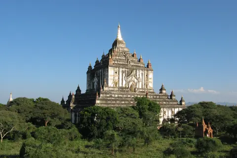
Earthquakes, Konbaung Repainting, and Conservation From 1975 to 2025
Active regional geology has tested Bagan's brick masonry repeatedly across centuries. Between 1904 and 1975 alone, instruments recorded over 400 earthquakes across Upper Myanmar before a major tremor struck on 8 July 1975. Measuring intensity 8 MM across Bagan and Myinkaba and 7 MM in Nyaung-U, the shock battered hundreds of vaults and irreparably shattered riverside Bupaya.
Human interventions complicated material authenticity long before modern preservation rules arrived. Fewer than 200 new monuments went up between the 15th and 20th centuries as pilgrimage narrowed onto roughly twenty famous temples along ancient roads, leaving outlying shrines to crumble. During the Konbaung dynasty (1752 to 1885), state-backed repairs whitewashed interiors at Thatbyinnyu and Ananda, painted new frescoes over original Pagan murals and clad older brick in coarse plasterwork lacking original refinement. Many painted inscriptions and devotional murals survive from that Konbaung revival, offering historical insight even where surface finishes hid earlier brick artistry. Later, 1990s military-government restorations using modern concrete styles, paired with a paved highway, golf course and 61-metre watchtower, drew international condemnation and delayed UNESCO status by 24 years until 6 July 2019, making Bagan Myanmar's second World Heritage listing after the Pyu Ancient Cities.
Recent earthquakes demonstrate why strict structural stewardship stays urgent across the plain. On 24 August 2016, a severe quake damaged nearly 400 temples, striking Sulamani and Myauk Guni heavily and leading DANM and UNESCO to bar public entry inside 33 severely damaged structures while upgrading disaster preparedness. Another major quake struck Myanmar near Bagan in March 2025, though key monuments including Htilominlo Pagoda and Shwezigon Pagoda escaped structural damage.
Contemporary statutory protection binds multiple national laws to landscape planning across the 100-kilometre by 100-kilometre protective buffer zone. The Bagan National Coordinating Committee (BAGANCOM) administers the Integrated Management Framework under Cultural Heritage Regions Law 20/2019, the 2015 Ancient Monuments Law and the 2015 Antique Objects Law with 2016 bylaws. Under UNESCO inscription commitments, national planners pledged to relocate intrusive hotels from the archaeological core to a dedicated hotel zone by 2020. Rigorous Heritage Impact Assessments now screen any new construction inside protected heritage tiers, supported by the commitment of local religious communities and surrounding villagers. Ongoing work aims to operationalise the Sustainable Tourism Strategy, Archaeological Risk Plan, Agriculture Sector Strategy and long-term Hotels Strategy across the living plain.
Balancing structural authenticity with active community life remains central to daily preservation across all serial components. Major temples and stupas retain authentic internal and external architectural forms, and many individual sanctuaries preserve original decorative stucco, painted murals and cloth works despite earlier interventions from the 1970s and 1990s. Keeping tourist hotel zones outside ancient brick fields prevents visual crowding while protecting fragile unexcavated foundations underground. Active Buddhist worship, daily merit-making offerings and traditional village farming continue sustaining intangible cultural practices beside ancient monuments across the plain. Local communities treat major stupas not as lifeless relics, but as functioning spiritual sanctuaries woven into seasonal calendar festivals and regional craft traditions.
Access Zones Across the Bagan Archaeological Zone
Grouping Bagan Myanmar temple exploration by historical belt avoids long midday crossings over dry sandy plains. Verify current zone passes and restricted structural notices with Department of Archaeology and National Museum desks before stepping onto temple platforms.
| Complex Zone | Key Highlights | Access & Ticket Rule |
|---|---|---|
| Old Bagan Core and Riverbank | Cruciform Ananda Temple, towering 12th-century Thatbyinnyu Temple, city walls and reconstructed riverside Bupaya stupa. | Active shrines require barefoot entry and modest dress; follow DANM closures across damaged upper terraces and 33 restricted sites. |
| Nyaung-U Northern Plain | Gilded Shwezigon Pagoda, lively morning town lanes and early 11th-century brick and sandstone shrines. | Connected by paved roads north of Old Bagan; stay strictly within public courtyard boundaries around unrestored brick mounds. |
| Myinkaba and Central Belt | Seismic-affected Sulamani and Myauk Guni temples, Htilominlo Pagoda and five-sided Dhammayazika along ancient pilgrim roads. | Accessible by local tracks and paved avenues; respect active scaffolding, safety barriers and conservation crews inside damaged vaults. |
| Minnanthu and Eastern Monasteries | 13th-century monastic brick compounds, compact lay-donor stupas and surviving interior Pagan-era painted frescoes. | Quiet eastern plains suited to daytime walks; avoid flash lighting or touching fragile wall plaster inside dim sanctuaries. |
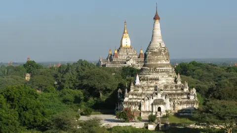
Three Masonry and Structural Details Around Bagan's Temples
- Pointed Brick Barrel Vaults Inside Ananda Temple: Walk through concentric stone-paved ambulatories to inspect radiating brick arches supporting massive upper masonry without structural timber beams. High side apertures channel soft natural light cleanly onto towering gilded Buddha images.
- Overpainted Konbaung Whitewash Over Pagan Frescoes: Examine interior corridor walls at Thatbyinnyu and Sulamani where patches of original 12th-to-13th-century mineral murals peek through late Konbaung whitewash (1752 to 1885) and painted ink inscriptions.
- Post-2016 Seismic Bracing and Restricted Upper Rooftops: Observe structural steel ties, brick buttressing and barred upper stairways erected after nearly 400 monuments suffered cracking during the August 2016 earthquake.
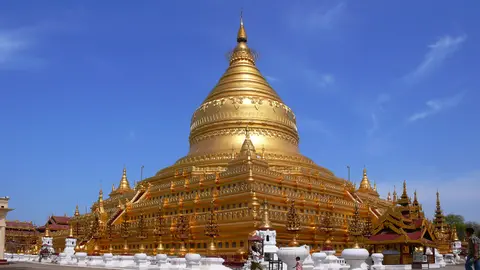
Bagan Myanmar Travel Conditions, Seismic Restrictions, and Timing
Organising bagan myanmar travel demands close attention to both central dry-zone weather and current national safety advisories. Extreme daytime heat bakes the sandy plain outside cooler winter months, making sunrise and late afternoon the clearest windows for touring brick compounds across the nine-kilometre corridor. Always consult official government travel advisories regarding Myanmar before booking regional flights or overland journeys into Mandalay Region.
Splitting sightseeing logically between Nyaung-U, walled Old Bagan and eastern Minnanthu reduces midday fatigue across exposed red-earth tracks. Starting early at Shwezigon Pagoda or Ananda Temple before intense afternoon glare sets in lets visitors study masonry reliefs and shaded vaulted ambulatories comfortably. Spending two to three unhurried days leaves enough time to trace 11th-century east-bank foundations before heading out to quieter 13th-century monastic clusters. Check updated DANM notices locally to respect every temporary scaffold barrier and permanent closure across the 33 earthquake-restricted structures.
International visitors generally transit via Mandalay International Airport (MDL), situated 128 kilometres northeast across Upper Myanmar, before continuing southwest by highway into Nyaung-U and Old Bagan. Regional Southeast Asian routes also extend farther across Thailand toward Chiang Mai (501 kilometres southeast). Explore more Southeast Asian brick temple complexes inside our UNESCO World Heritage Atlas.