


























Quick Field Data
- UNESCO Inscription: Inscribed in 1987 (criterion iii) as Chaco Culture National Historical Park and renamed Chaco Culture in 2006 across northwestern New Mexico, United States.
- Scale & Footprint: Protects 14,261 hectares encompassing 10 listed archaeological components, including Chaco Canyon, Aztec Ruins National Monument, and five outlying ancestral Pueblo sites.
- Access & Ticketing: Managed jointly by the National Park Service, federal Bureau of Land Management stewards, State of New Mexico agencies, and the Navajo Nation; check the official site for unpaved road conditions and entry passes.
- Arrival Logistics: Situated in the high desert of the Four Corners region in northwestern New Mexico, reached via unpaved county roads into Chaco Canyon and paved highways to Aztec Ruins.
Set within the arid high-desert plateaus and sandstone mesas of northwestern New Mexico in the southwestern United States, Chaco Culture preserves the monumental heart of a pre-Columbian ancestral Pueblo civilisation that flourished across the Four Corners region between 850 and 1250 CE. While Pueblo peoples occupied the wider American Southwest for more than 2,000 years, Chaco Canyon emerged over four centuries, reaching its architectural and social peak between about 1020 and 1110, as the primary ceremonial, economic, and political centre of the region. Nominated by the United States Department of the Interior under Criterion (iii) of the 1972 World Heritage Convention and inscribed in the UNESCO World Heritage Atlas in 1987 (with its official designation updated to Chaco Culture in 2006), the protected area covers 14,261 hectares and unites 10 distinct archaeological sites across federal, state, and tribal lands.
What makes the Chacoan achievement so striking is the scale and geometric precision of its public and ceremonial buildings within an austere, water-scarce canyon environment. Across the floor and rim of Chaco Canyon and at northern and southern outlier communities, ancestral Pueblo architects constructed monumental multi-storey masonry complexes known as great houses alongside vast subterranean circular chambers called great kivas. Linked across the desert by an engineered network of straight, wide prehistoric roads and visual signalling stations, the 10 protected World Heritage locations, Chaco Canyon's historical park, the northern complex at Aztec Ruins National Monument, Salmon Ruins, Kin Bineola, Kin Ya'a, Twin Angels, Halfway House, Pierre's site, Kin Nizhoni, and Casamero, demonstrate how an ancestral Pueblo society organised labour, trade, astronomy, and ritual on a regional scale unlike anything built in the Southwest before or since.
Coursed Sandstone Masonry, Great Kivas, and Prehistoric Roads
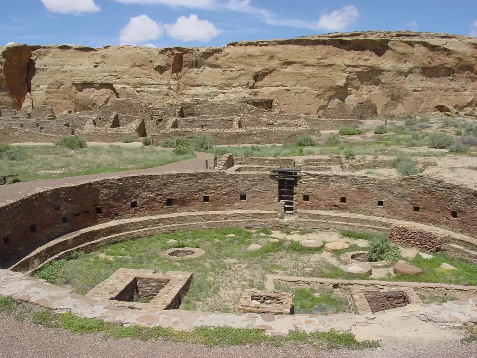
Walking beside the towering walls of a Chacoan great house such as Chetro Ketl reveals a level of stone masonry and pre-planned urban design that set Chaco apart from earlier pit-house and unit-pueblo villages. Builders quarried tabular sandstone blocks from the canyon cliffs and dressed them into tightly fitted, coursed ashlar veneers encasing thick rubble-and-mortar cores. Using timber beams hauled from distant mountain forests to frame floors and roofs, they raised stepped complexes rising up to four storeys and containing hundreds of interconnected rooms arranged around central plazas. The high concentration of interior storage rooms within these great houses indicates that Chaco Canyon functioned as a central economic repository and redistribution hub for the wider Four Corners basin.
Embedded within the plazas of the great houses and standing as independent community sanctuaries are the ceremonial kivas and great kivas, including the famous great kiva plaza of Chetro Ketl. Far larger and more elaborate than domestic clan rooms, these circular subterranean chambers incorporate masonry bench linings, paired floor vaults, roof-support pillar pits, and directional niches that anchored complex seasonal rituals and astronomical observations. Radiating outward from Chaco Canyon toward outlier great houses like Kin Bineola, Kin Ya'a, Casamero, Kin Nizhoni, Pierre's site, Halfway House, and Twin Angels, and extending north toward Salmon Ruins and Aztec Ruins National Monument, were carefully engineered roads cleared through desert scrub and carved with rock-cut stairways where they met vertical cliff faces.
Exploring Chaco Canyon, Aztec Ruins, and the Outlier Network
Because the 14,261-hectare World Heritage designation spans multiple jurisdictions across northwestern New Mexico, managed by the National Park Service, federal Bureau of Land Management stewards, State of New Mexico agencies, and the Navajo Nation, visiting Chaco Culture requires planning for two very different field environments. The core canyon inside Chaco Culture National Historical Park sits at the end of rough, unpaved dirt roads that can become impassable after rain or snow, rewarding self-sufficient travellers with quiet loop trails through great houses and kivas. Farther north, Aztec Ruins National Monument and Salmon Ruins sit directly alongside paved highways, offering accessible introductions to Chacoan multi-storey masonry and reconstructed great kiva architecture.
- Verify unpaved road conditions before entering Chaco Canyon: The approach tracks into Chaco Culture National Historical Park cross remote washes and clay soil; check the official site of the National Park Service for current road advisories, drinking water availability, and trail access before leaving paved highways.
- Compare the canyon great houses with Aztec Ruins: Walk the canyon floor trails around Chetro Ketl and its great kiva plaza to study coursed sandstone veneers in situ, then visit Aztec Ruins National Monument and Salmon Ruins to see how the Chacoan architectural system extended northward between 1020 and 1250.
- Respect fragile masonry and outlying Bureau of Land Management sites: When visiting remote outlier great houses such as Kin Bineola, Kin Ya'a, Casamero, or Pierre's site, stay strictly on marked paths and never lean on or climb original 9th- to 13th-century sandstone walls.
For more than four centuries between 850 and 1250 CE, ancestral Pueblo communities across the prehistoric Four Corners basin looked to Chaco Canyon as their ceremonial, architectural, and economic anchor. Sandstone walls dominate the canyon. Although Pueblo peoples inhabited the wider southwestern United States for over 2,000 years, the society that coalesced in northwestern New Mexico reached a distinctive height between about 1020 and 1110. Overcoming a harsh, arid climate with short growing seasons and scarce surface water, Chacoan builders engineered multi-storey great houses of coursed sandstone masonry alongside subterranean circular kivas whose scale and precision had no parallel in the pre-Columbian Southwest.
When the World Heritage Committee reviewed the nomination prepared by the United States Department of the Interior under the 1972 World Heritage Convention in 1987, it praised the monumental architecture, sophisticated astronomical alignments, and engineered road traces of Chaco Culture National Historical Park while recommending that additional Puebloan sites be incorporated. As a result, the 14,261-hectare designation, whose title was shortened in 2006 to Chaco Culture, protects 10 separate locations across federal, state, and Navajo Nation lands: the main canyon park, the northern complex at Aztec Ruins National Monument, Salmon Ruins, Kin Bineola, Kin Ya'a, Twin Angels, Halfway House, Pierre's site, Kin Nizhoni, and Casamero. Together with related ancestral Pueblo heritage across the Four Corners such as Mesa Verde National Park, these 10 components preserve the high concentration of storage rooms, great kivas, and regional road alignments that linked outlying communities to the central canyon and demonstrated the social, economic, and ritual complexity of Chacoan civilisation across northwestern New Mexico for more than four centuries.
Preservation Challenges Across the Greater Chaco Landscape
Since the 1987 inscription, heritage managers have slowed natural weathering and visitor wear inside the protected boundaries through partial room reburial, protective fencing, masonry stabilisation, and ranger patrols. Yet because the prehistoric road traces and outlier communities of the wider Chacoan system extend well beyond the 14,261-hectare World Heritage boundary, the surrounding basin faces mounting pressures from adjacent utility corridors, road grading, and mineral extraction. In 2026, preservation advocates at the National Trust for Historic Preservation included the Greater Chaco Cultural Landscape among the 11 Most Endangered Historic Places in America following proposals to lift federal buffer protections and expand oil and gas development near the park.
Standing on the canyon floor as desert light moves across the banded sandstone walls of Chetro Ketl makes clear why protecting both the core monuments and their surrounding horizon matters. Chacoan builders aligned their great houses, kivas, and regional roads with solar and lunar cycles and with distant landforms across the Four Corners plateau. Preserving that unbroken desert setting allows modern visitors to read the astronomical and architectural order that held ancestral Pueblo society together for four hundred years.
