


























Quick Field Data
- UNESCO Inscription: 1978 · Criterion (iii)
- Scale & Footprint: 52,485 acres (212 km2 / 21,240 ha) in Montezuma County, Colorado, containing 4,372 to over 5,000 documented archaeological sites including 600 cliff dwellings and an 8,500-acre wilderness buffer
- Access & Ticketing: Park entry fees apply at the U.S. Route 160 gate; mesa-top loop drives and overlooks are self-guided, while entering Cliff Palace or Balcony House as well as Long House requires advance ranger-guided tour tickets
- Arrival Logistics: Entrance lies on U.S. Route 160 in southwestern Colorado, located 14 km (9 miles) east of Cortez and 11 km (7 miles) west of Mancos, with Chapin Mesa situated 20 miles (32 km) beyond the entrance Visitor and Research Center
Cretaceous Cuestas, Sandstone Alcoves, and Passive Solar Engineering
Rising from 6,000 feet (1,829 m) up to 8,572 feet (2,613 m) at Park Point in Montezuma County near the Four Corners region of southwestern Colorado, Mesa Verde National Park protects 52,485 acres (212 km2) of high juniper and piñon plateau incised by deep sandstone canyons. Sandstone and sun shaped every village here. Named Mesa Verde ('green table') in 1776 by Spanish padres Silvestre Vélez de Escalante and Francisco Atanasio Domínguez, the landform is geologically a south-tilting cuesta rather than a flat mesa. That gentle southward tilt, averaging around 7,000 feet (2,100 m) across the middle plateaus, increases solar exposure for dryland farming on the mesa tops while driving the hydrological erosion that hollowed out the canyon alcoves below.
Four Late Cretaceous rock units govern the architecture of the park. At the base lies the clay-rich Mancos Shale deposited over Dakota Sandstone in the deep Cretaceous Sea, topped by the three formations of the Mesaverde Group: the massive, 400-foot (100 m) thick Point Lookout Sandstone (reaching 8,427 ft / 2,569 m at Point Lookout), the middle Menefee Formation of carbonaceous shales and siltstones with thin coal seams, and the upper 400-foot (100 m) thick Cliff House Sandstone, whose fossiliferous yellow canyon faces crown the rims. Because rainwater and snowmelt seep down through the porous Cliff House Sandstone until hitting impermeable shale lenses inside the cliff wall, water emerges horizontally at seeps and springs along the canyon faces. Over millennia, winter freeze-thaw erosion along those wet shale seams undercut the sandstone into immense arched alcoves.
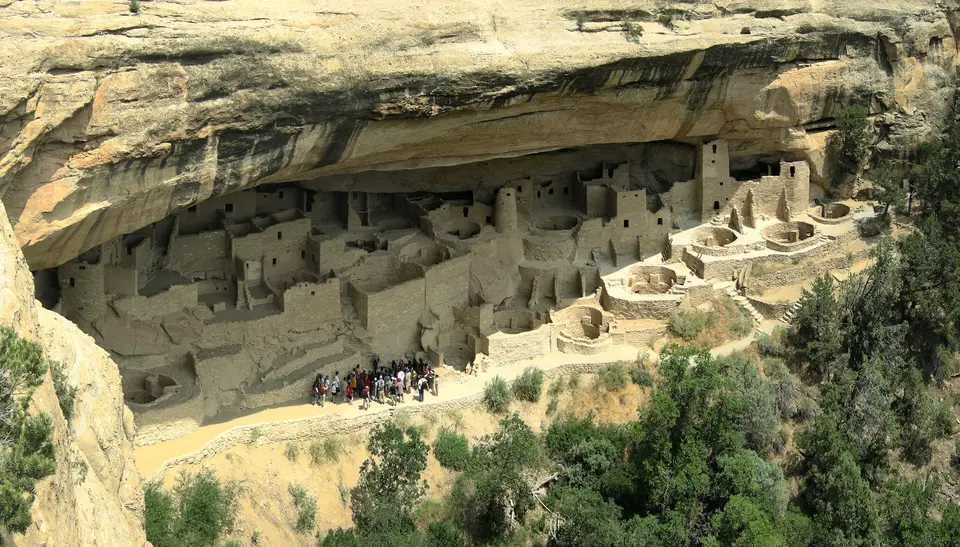
When Ancestral Puebloan builders moved from the mesa tops into these canyon alcoves at the end of the 12th century, they exploited a natural passive solar microclimate. Facing predominantly south and southwest, the deep overhangs shielded multi-storey masonry villages from direct overhead sun during hot summers, while in winter the low angle of the southern sun shone deep into the alcoves, warming the sandstone blocks and adobe mortar so that air temperatures inside the alcoves remained 10 to 20 °F (5 to 10 °C) warmer than the windswept mesa top above.
Across the mesa tops and canyon walls, archaeologists have documented between 4,372 and over 5,000 sites, including 600 sandstone-and-mortar cliff dwellings ranging from small storage structures to 150-room villages. Complementing the residential pueblos is a vast hydraulic and agricultural infrastructure uncovered across the landscape, including 593 additional sites, 1,189 check dams, and 344 farming terraces revealed after wildfires burned 28,340 acres between 1996 and 2003, alongside four masonry water reservoirs (Morefield and Box Elder in the canyons plus Far View and Sagebrush on the mesa top) constructed between 750 and 800 CE along a 6-mile (10 km) east-west line and designated as National Civil Engineering Historic Landmarks in 2004.
From Basketmaker Pithouses to Cliff Palace and the Great Drought
Human presence on the plateau began with nomadic Paleo-Indians of the Foothills Mountain Complex around 9500 and 7500 BCE using the atlatl, followed after 6000 BCE by Archaic rock-shelter inhabitants. Around 1000 BCE, the introduction of corn and permanent pithouses marked the emergence of the Basketmaker II culture, famed for finely woven baskets and yucca sandals alongside rock art depicting the flute player Kokopelli. During the Basketmaker III era (500 to 750 CE), villagers adopted the bow and arrow, cultivated beans, and corn and squash, and fired ceramic cooking vessels using Menefee and Mancos alongside Morrison clays that allowed beans to be boiled into complete dietary protein.
Between 750 and 900 CE in the early Pueblo period and 900 to 1150 CE in the Pueblo II period, builders shifted household life into above-ground jacal and stone masonry unit pueblos while transforming subterranean pithouses into circular ceremonial kivas spanning 12 to 15 feet across (or 3.7 to 4.6 m), complete with a northern floor hole (sipapu) symbolizing emergence from the underworld. Between 1075 and 1125, Chacoan architectural influence produced multi-storey masonry great houses on the mesa top such as Far View House, linked by 15 to 45-foot-wide bermed roads and C-shaped herradura shrines.
After a severe drought between 1130 and 1180 collapsed the Chaco Canyon system, populations aggregated across the Mesa Verde region, reaching roughly 22,000 inhabitants at the start of the 13th century, and during the Pueblo III era (1150 to 1300 CE) builders constructed the monumental cliff dwellings inside the canyon alcoves. Built from shaped blocks of Cliff House Sandstone laid in mud mortar with T-shaped doorways and brightly plastered red, yellow, white, green, brown, and blue kiva murals, Cliff Palace in the central Great Mesa alcove became the largest village in the park, containing 150 rooms and 23 kivas alongside multi-storey towers housing around 125 people within a 60-pueblo community. On Wetherill Mesa, Long House (built c. 1200 to 1280 and excavated from 1959 to 1961) matched that scale with 150 rooms and a central plaza with overhead grain ledges, alongside Mug House (94 rooms) and Chapin Mesa's Spruce Tree House (130 rooms and 8 kivas, built 1211 to 1278). On a high east-facing ledge, Balcony House (45 rooms and two kivas, with a roof beam dated to 1278 and excavated by Jesse L. Nusbaum in 1910) was engineered for defence, accessible only via a narrow 12-foot (4 m) rock tunnel and cliff-face toe-holds. Directly across Fewkes Canyon from Cliff Palace stands the D-shaped Sun Temple, aligned 10.7 degrees off true east-west to track the winter solstice sunset and the 18.6-year major lunar standstill.
Tree-ring dating shows that the last construction timber on the mesa was felled in 1281. Strained by deforestation and soil depletion alongside clan warfare and the prolonged Great Drought from 1276 to 1299, the Ancestral Puebloans vacated Mesa Verde by 1285, migrating south to the Rio Chama and the Pajarito Plateau as well as the Rio Grande Valley and the Little Colorado River, where their descendants live today in modern pueblos including Acoma and Zuni alongside Jemez and Laguna. Preserved on Ute tribal lands under the treaties of 1868 and 1873, the ruins were photographed by William Henry Jackson after 1873, championed for federal protection by journalist Virginia McClurg from 1882 to 1906, explored by rancher Richard Wetherill and Charlie Mason in December 1888 and Swedish mineralogist Gustaf Nordenskiöld in 1891, stabilized by Smithsonian ethnologist Jesse Walter Fewkes from 1908 to 1922, and established by President Theodore Roosevelt in June 1906 as the first United States national park created to preserve cultural works, gaining UNESCO World Heritage status in 1978.
Navigating Chapin Mesa and Guided Alcove Ladders
Visiting Mesa Verde requires allowing a full hour of winding mountain driving from the U.S. Route 160 entrance just to reach the cliff dwellings on Chapin Mesa, 20 miles (32 km) south of the entrance booths. While the 8,500-acre backcountry wilderness is strictly closed to public entry to protect fragile archaeological sites and Spruce Tree House remains closed due to rockfall hazards, self-guided mesa-top loops and ranger-led alcove tours provide intimate access to both surface pueblos and cliff dwellings.
- Visitor and Research Center to the Chapin Mesa Top Loop: Stop first at the Mesa Verde Visitor and Research Center at the Highway 160 entrance (opened in December 2012) to check trail status and confirm timed tour reservations, then climb the steep switchbacks past Point Lookout (8,427 ft) and Park Point (8,572 ft) to Chapin Mesa. Drive the 6-mile Mesa Top Loop Road to trace the full chronological evolution from 6th-century Basketmaker pithouses and early Pueblo villages to the Chacoan masonry of the Far View Complex, Cedar Tree Tower, the canyon-rim overlook into Square Tower House, and the ceremonial walls of Sun Temple overlooking Fewkes Canyon and Cliff Palace.
- Climbing into Cliff Palace, Balcony House, and Wetherill Mesa's Long House: Book ranger-guided tickets in advance to descend the uneven stone steps and climb wooden ladders through the 150 rooms and 23 kivas of Cliff Palace, or test your agility on the Balcony House tour by ascending a 32-foot (10 m) exposed cliff ladder and crawling on hands and knees through the 12-foot (4 m) defensive stone tunnel. In summer, drive the secondary road out to Wetherill Mesa to inspect the Badger House Community and join a ranger tour into the 150-room cavern of Long House.
- Seasonal road openings, high-altitude sun, and Ute Mountain connections: Plan your visit between late May and October when the Wetherill Mesa road and all three guided cliff-dwelling tours operate; in winter, only the Chapin Mesa Archaeological Museum, the 1920s National Historic Landmark administrative district, and the Mesa Top Loop remain open. Because Chapin Mesa sits above 6,952 feet (2,119 m), carry ample drinking water when climbing alcove ladders. Extend your Four Corners archaeology route by hiring a Native American Ute guide in the adjoining 125,000-acre Ute Mountain Tribal Park along the Mancos River and consulting our UNESCO World Heritage Atlas.
