


























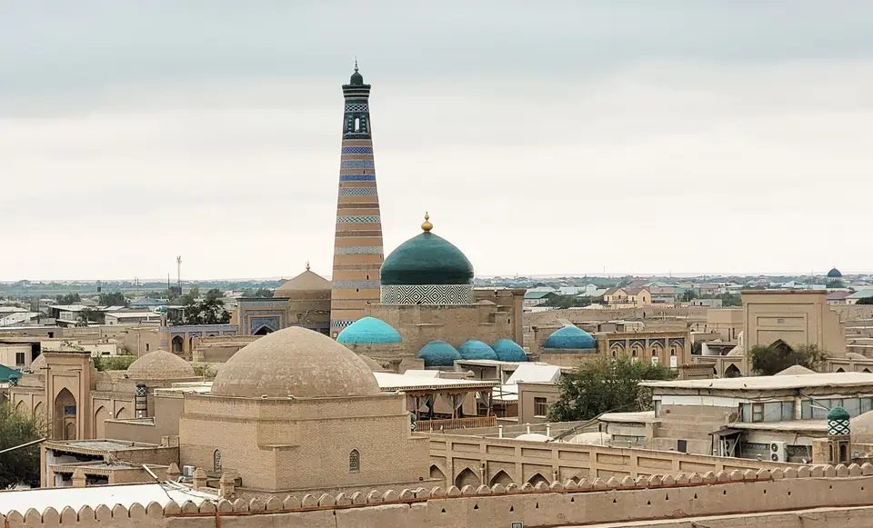
Quick Field Data
- UNESCO Inscription: 1990 (Cultural, Criteria iii, iv, v; Property ID 543).
- Scale & Footprint: Rectangular walled inner fortress of Khiva (measuring 650 by 400 metres across 26 ha, with a 37.5 ha listed area and a 6,250-metre wall perimeter 8 to 10 m high and 5 to 6 m thick) containing 51 ancient monumental structures and 250 traditional dwellings.
- Access & Ticketing: Historic walled inner town entered through four mud-brick city gates; check the official site for combined monument tickets covering the palaces, madrasahs, mausoleums, and minarets.
- Arrival Logistics: Located at 41.3781°N, 60.3603°E southward from the Amu Darya River (ancient Oxus) in the city of Khiva within the Khorezm region of Uzbekistan.
Two Millennia of Oasis Fortifications South of the Amu Darya
Positioned at 41.3781 degrees north and 60.3603 degrees east southward from the Amu Darya River, known in antiquity as the Oxus, in the Khorezm region of Uzbekistan, Itchan Kala forms the fortified inner town of the ancient Khiva oasis. Across more than two millennia of desert trade, this oasis functioned as the final resting place for merchant caravans preparing to cross the desert toward Persia (Iran). Local foundational legends link the oasis to the earliest history of the region: one tradition holds that clay excavated from this ground was carried away to build structures in Medina when the Prophet Muhammad was alive, while the lake that subsequently formed on the site came to be revered as sacred. A second tradition recounts that Shem, the son of Noah, used a miraculous spade to excavate Khiva's sacred water channel, the Xeyvak Canal, initiating the construction of Khorezm itself.
In accordance with traditional Central Asian urban planning, Khiva is divided into two distinct concentric sectors: the inner fortress of Itchan Kala, encircled by the Inner Defensive Wall, and the surrounding outer town (called the robod), Dishan-Qal'a (or Dishan Kala), enclosed by its own Outer Defensive Wall. Built as a regular south-to-north elongated rectangle measuring 650 by 400 metres across 26 hectares (with a 37.5-hectare World Heritage area), Itchan Kala is enclosed by mud-brick fortification walls rising 8 to 10 metres in height, measuring 5 to 6 metres in thickness, and spanning a total perimeter length of 6,250 metres. Semicircular watchtowers project outward from the mud-brick curtain wall at regular intervals of every 30 metres, while the upper ramparts are crowned with defensive crenellations designed for archers and defenders during sieges. Beyond the base of the walls, water-filled moats originally completed the defensive perimeter; visible traces of these moats still survive along the southern flank of the city, whereas in the northern and western sectors ancient clay pipes were laid down to cover the moat channels. Four monumental gates pierce the cardinal sides of the mud-brick circuit: Bogcha Gate in the north, Polvon Gate (Polvan Gate) in the east, Tosh Gate in the south, and Ota Gate in the west. Each gateway was fortified with flanking "zarba" towers on either side of the entranceway, upper defensive galleries above the portal, and arched interior passageways roofed with multiple domes where the entry road ran deep through the ramparts.
Architectural historians divide the construction of Itchan Kala into four principal chronological phases. The first phase extends from ancient Khorezm up to the Mongol invasion of 1220; surviving structures from this earliest era include the western wall of the Konya Ark citadel, the ancient north-eastern corner tower of the castle rampart, and sections of the defensive walls. The second phase followed the post-1220 restoration of Khorezm after the Mongol invasion, when master builders erected the Sayid Allavuddin (Said Alovuddin) Mausoleum and other early Islamic monuments. The third phase spans the 16th and 17th centuries when Abulgazi Khan and Asfandiyar Khan ruled, witnessing the erection of Anusha Khan's bathhouse in 1657, the Ak Mosque (Oq Mosque) in 1675, and the madrasah of Khojamberdibi in 1688, alongside the strengthening of the Konya Ark fortifications and the building of the khan's reception and viewing hall between 1686 and 1688. During the first half of the 18th century, warfare between Bukhara and Iran for control of the Khanate of Khiva severely damaged both Itchan Kala and Khiva, reducing Khiva for a period to a province dependent on Iran.
Hypostyle Columns at Djuma Mosque and Nineteenth-Century Khorezmian Palaces
The fourth and most prolific building phase unfolded between the 18th and 20th centuries, when Khorezmian master builders restored the ruined perimeter walls, laid out a primary east-west thoroughfare linking the city gates, and integrated major palaces, madrasahs, indoor markets (tims), and mausoleums into the traditional urban fabric. Most of the 51 ancient monumental structures and 250 traditional dwellings standing inside Itchan Kala today date from the 18th and 19th centuries. In Uzbekistan, the centre of inner town stands the Djuma Mosque (Juma Mosque), originally founded in the 10th century and rebuilt between 1788 and 1789 with a tall brick minaret rising beside its entrance. Designed specifically for the rugged continental climate of Central Asia, the Djuma Mosque takes the form of a single-storey covered courtyard measuring 55 by 46 metres inside, faintly illuminated by two octagonal roof lanterns and supported by a hypostyle forest of 212 wooden columns, of which 112 carved columns were salvaged from older medieval structures.
Construction across the inner fortress accelerated rapidly under the 19th-century reigns of Muhammad Rahim Khan I, who ruled from 1806 to 1825, Alla-Kulli-Khan (1825 to 1842), and Muhammad Amin Bahadur Khan (1845 to 1855). During these decades, builders completed the royal palace complex inside the western Konya Ark citadel and erected the expansive Toshhovli Palace, alongside the Pahlavon Mahmoud (Pahlavon Mahmud) Mausoleum, celebrated as a masterpiece of Khorezmian folk art and glazed tilework, and the mausoleum of Shergozikhon. Near the eastern Polvon Gate, part of the old fortress wall was demolished so that Alla-Kulli-Khan could construct an integrated commercial and religious complex comprising the Alla-Kulli-Khan caravan palace (caravanserai), madrasah, and covered market, while between 1840 and 1842 a two-storey indoor market (tim) was erected in front of the Kutlugmurad Inaq Madrasah.
Across the social zones of the inner town stand the monumental madrasahs of Muhammad Aminkhon (Muhammad Aminkhan Madrasah), Muhammad Rakhimkhon, Arab Muhammad Khan (Arab Muhammadkhan Madrasah), and Musa Torah, accompanied by the Hasanmurod Qushbegi Mosque and the courtyard pavilion of Ishrat Hovli. Immediately adjacent to the Konya Ark in the western sector rises the famous Kaltaminor minaret, commissioned by Muhammad Amin Khan; although left unfinished after the khan's death, its wide, glazed cylindrical shaft remains a defining visual landmark of Khiva. Surrounding these public ensembles are 250 enclosed courtyard houses from the 18th to 20th centuries, each built with high mud-brick walls, private family quarters, and a shaded reception room opening onto a portico or aivan (avian) supported by delicately sculpted wooden posts.
Navigating the Four Gates and Courtyard Streets of Khiva
Protected as a cultural site on the UNESCO World Heritage Atlas since 1990 under Criteria iii, iv, and v, Itchan Kala derives its exceptional urban character from the harmony uniting its 51 historic monuments with its 250 inhabited mud-brick courtyard homes. Walking the brick-paved streets between Ota Gate and Polvon Gate allows travellers to experience a complete Central Asian oasis town where caravanserais, domed markets, madrasahs, and domestic aivans still stand within their 6,250-metre mud-brick enclosure. You can pinpoint Khiva and the Amu Darya oasis corridor on our interactive world map. Crenellated mud walls glow at dusk.
- Walking the mud-brick ramparts and four city gates: Trace the 8-to-10-metre-high inner defensive walls with their projecting watchtowers spaced every 30 metres, inspecting Ota Gate in the west, Bogcha Gate in the north, Polvon Gate in the east, and Tosh Gate in the south along with the southern moat remnants.
- Examining the 212 columns of Djuma Mosque and Pahlavon Mahmoud Mausoleum: Step inside the 55-by-46-metre covered hall of the 1788 to 1789 Djuma Mosque to study the 112 ancient carved wooden columns beneath the two octagonal lanterns, then visit the nearby Pahlavon Mahmoud Mausoleum, the medieval Sayid Allavuddin Mausoleum, and the 1675 Ak Mosque.
- Exploring Konya Ark, Toshhovli Palace, and the eastern market ensembles: Tour the 1686 to 1688 reception hall and royal courts of the Konya Ark beside the unfinished Kaltaminor minaret and Muhammad Aminkhon Madrasah before walking east to Toshhovli Palace, the 1840 to 1842 two-storey tim opposite Kutlugmurad Inaq Madrasah, and the caravanserai and madrasah of Alla-Kulli-Khan.
