


























Quick Field Data
- UNESCO Inscription: 1981 (proclaimed in stages between 1979 and 1991, with extensions in 1987 and 1992 followed by 2011) · Mixed Cultural and Natural Criteria
- Scale & Footprint: 19,804 square kilometres extending nearly 200 kilometres north-to-south and over 100 kilometres east-to-west across the Alligator Rivers Region
- Access & Ticketing: Managed jointly through Parks Australia by the Director of National Parks and Aboriginal traditional owners, with a park use fee reintroduced in April 2010
- Arrival Logistics: Situated in the Northern Territory of Australia, 171 kilometres southeast of Darwin along the regional highway corridor serving Jabiru and the Alligator Rivers
Arnhem Land Escarpment Geology and Four Monsoonal River Catchments
Kakadu National Park spans 19,804 square kilometres in the Alligator Rivers Region of Australia's Northern Territory, lying 171 kilometres southeast of Darwin between 12 and 14 degrees south of the Equator. Comparable in area to Wales or a third of Tasmania, the reserve extends nearly 200 kilometres from north to south and more than 100 kilometres from east to west, ranking behind only the Simpson Desert reserve (proclaimed in November 2021) among Australian national parks. The landscape is organised around six distinct landforms: the stone country of the Arnhem Land escarpment and plateau; isolated sandstone outliers; gently undulating lowlands covering nearly 70 percent of the park; ancient volcanic southern hills and basins dating back 2,500 million years; vast seasonal floodplains listed under the Ramsar Convention; plus coastal estuaries and tidal mudflats extending 100 kilometres inland.
Approximately 140 million years ago, a shallow sea covered most of this basin, and today's jagged escarpment walls formed as ancient sea cliffs above a flat plateau while isolated sandstone outliers stood as offshore islands. Rising up to 330 metres above the plains, the unbroken escarpment runs for roughly 500 kilometres along the eastern boundary and into Arnhem Land, shifting from sheer vertical cliffs around Jim Jim Falls to stepped terraces and outliers in the north. Across the dry sandstone plateau, scarce topsoil and rapid drainage feed a network of deep chasms and gorges where cool, moist microclimates shelter tall monsoon forests dominated by Allosyncarpia ternata, a shady tree species restricted to Kakadu and Arnhem Land.
Below the stone country, four major river systems drain the park toward the Van Diemen Gulf: the entire catchment of the South Alligator River alongside the East Alligator and West Alligator plus the Wildman River. Annual rainfall ranges from 1,565 millimetres at Jabiru (where average maximum temperatures reach 32 degrees in June and July, 37.5 in October, and 33 in January) to 1,300 millimetres in the Mary River region. While non-Indigenous visitors divide the year into wet and dry periods, Bininj and Mungguy traditional owners recognise six ecological seasons: Kunumeleng pre-monsoon storms from mid-October to late December, Kudjewk monsoon floods from January to March, Bangkerreng knock-em-down windstorms in April, Yekke cool low-humidity burning months from May to mid-June, Wurrkeng cold dry months from mid-June to mid-August, and Kurrung hot dry billabong-shrinking weather from mid-August to mid-October. These hydrologic shifts sustain more than 1,700 plant species (including resurrection grasses on the stone country, Eucalyptus koolpinensis near Koolpin Gorge, Kakadu plum Terminalia ferdinandiana, paperbark Melaleuca, banyan figs, yellow-flowered Cochlospermum fraseri, and 39 of the Northern Territory's 47 mangrove species). They also support 74 mammal species, 280 bird species across an 11,246-square-kilometre Important Bird Area (including the endangered Gouldian finch and red goshawk alongside the hooded parrot and magpie geese), 50 freshwater fish species such as barramundi, 10,000 insect species, and 117 reptile species led by freshwater crocodiles (Crocodylus johnstonii) and estuarine saltwater crocodiles (Crocodylus porosus).
Sixty Millennia of Bininj Rock Art and Uranium Disputes
Aboriginal people have inhabited Kakadu continuously for at least 40,000 and up to 60,000 or 65,000 years, making its hunting-and-gathering tradition one of the longest living anthropological records on earth. More than 5,000 recorded rock art sites, including major galleries at Ubirr and Nourlangie, chronicle shifts in Pleistocene and Holocene fauna alongside social structure and ceremony before and after the last ice age. The park's name derives from Gaagudju, an Aboriginal language from the northwestern sector that explorer Baldwin Spencer mispronounced as Kakadu; at the onset of British colonisation, resident First Nations groups included the Bininj, Kunwinjku, Kundjeymi, Gaagudju, Bukurnidja, Ngurmbur, and Wuningangk plus Mbukarla peoples. From the late seventeenth century, Makassan trepang fishermen from Sulawesi sailed praus to northern Australia each wet season, leaving glass and metal trade fragments in Kakadu's archaeological strata.
Maritime surveys by Dutch navigator Abel Tasman in 1644 and Maerten van Delft in 1705 bypassed the inner coast until English navigator Phillip Parker King charted the estuaries in 1818 and named the three Alligator Rivers after mistaking estuarine crocodiles for alligators. Short-lived British outposts on the Cobourg Peninsula at Fort Wellington in 1829 and Victoria Settlement at Port Essington in 1838 (abandoned in 1849) released domestic Asian water buffalo that multiplied into destructive feral herds across the floodplains. Overland explorer Ludwig Leichhardt descended Jim Jim Creek and crossed the South and East Alligator rivers in 1845 with the help of local Aboriginal guides, whereas later expeditions by John McDouall Stuart in 1862 alongside John McKinlay and James Thomas Manton in 1866 and pastoralist John Lewis in 1874 and 1875 led to violent armed clashes. Pastoral leases at Gimbat and Goodparla plus Gerowie stocked by R. Travers and A. W. Sergison from 1877 failed by 1889 (and were acquired for the park in 1987), while dry-season buffalo hide hunting from the 1880s, cypress-pine sawmilling at Nourlangie Camp (converted into a safari camp in 1958 alongside Patonga and Muirella Park), the brief Kapalga Native Industrial Mission in 1899, and the Church of England Oenpelli Mission at present-day Gunbalanya (operating for 50 years from 1925) reshaped local livelihoods until freshwater and saltwater crocodiles gained legal protection in 1964 and 1971.
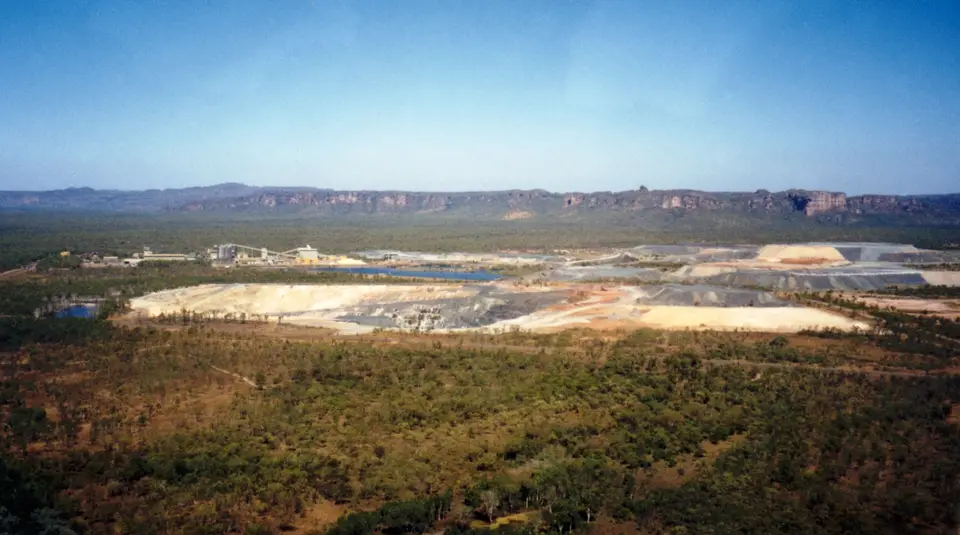
Mineral extraction triggered the modern conservation struggle. Following gold discoveries along the Overland Telegraph line (1870 to 1872) and the North Australia Railway (1889 to 1976) at Pine Creek, Imarlkba, and Mundogie Hill plus Moline, prospectors found uranium in the South Alligator valley in 1953, operating thirteen small mines that employed 150 workers in 1957 before discovering massive deposits at Koongarra and Jabiluka alongside Ranger in the early 1970s. Following the Ranger Uranium Environmental Inquiry (the Fox inquiry), the park was proclaimed in stages between 1979 and 1991 under the 1999 Environment Protection and Biodiversity Conservation Act (EPBC Act). Campaigns by the Kakadu Action Group formed by Lindsay Mollison at the Australian Conservation Foundation in Melbourne helped persuade Prime Minister Bob Hawke to veto gold and platinum mining by BHP at Coronation Hill (Guratba) and El Sherana in May 1991, adding Stage 3 in 1992. A subsequent blockade led by the Gundjeihmi Aboriginal Corporation and Gaagudju elder Bill Neidjie halted the Jabiluka uranium mine (added in 1996), Koongarra joined the World Heritage area in 2011, and the Ranger Uranium Mine finally ceased operations in January 2021. Today, following the Aboriginal Land Rights Act 1976 and the formal handback ceremony by Minister Ken Wyatt on 24 March 2022 to traditional owners including the Mirrar Kundjeyhmi, Dadjbaku, Djindibi, Bunidj, Uwinymil, Madjba, Wurrkbarbar, Bolmo, Wurngomgu, Yulhmanj, Karndidjbal, Murumburr, and Minitja plus Limingan peoples, the reserve is governed by the fifteen-member Kakadu Board of Management (established in 1989 with ten Aboriginal members) and staffed one-third by Aboriginal rangers.
Traversing the Stone Country Outliers and Billabongs
With 313 permanent residents recorded in the 2016 census and seasonal floods that transform gravel tracks into inland seas, exploring Kakadu requires aligning your route with the six Bininj and Mungguy seasons. The sandstone cliffs glow at dusk.
- Entry and Route to Ubirr and the East Alligator: Drive 171 kilometres southeast from Darwin into the Alligator Rivers Region to secure your park pass and head first to the northern sandstone outlier of Ubirr near the East Alligator River. Walk the perimeter rock shelters to study multi-layered paintings of barramundi and wallabies alongside early contact figures, then climb the rocky lookout before sunset to watch the Ramsar wetlands and paperbark floodplains stretch toward Arnhem Land.
- Tickets, Interiors and Viewpoints at Nourlangie and Jim Jim: Follow the central highway south past Jabiru to the Nourlangie rock art precinct, where sheltered overhangs preserve thousands of years of ceremonial ochres above the site of the historic cypress-pine sawmill. During the dry months of Yekke, Wurrkeng, and Kurrung from May to October, take a four-wheel-drive track to the 330-metre vertical sandstone walls of Jim Jim Falls or Koolpin Gorge (Jarrangbarnmi) to see monsoon pockets of Allosyncarpia ternata.
- Timing and Onward Connections across the Top End: Schedule overland travel between May and September when dry trade winds keep humidity low and billabong boat cruises reveal estuarine crocodiles alongside hundreds of thousands of magpie geese and brolgas, or visit during the Kudjewk wet season from January to March for scenic flights over roaring escarpment waterfalls. Pair your Top End expedition with Australia's arid interior reserves in our UNESCO World Heritage Atlas.
