


























Quick Field Data
- UNESCO Inscription: 1988 (Natural Criteria ix, x); placed on the List of World Heritage in Danger in 1997
- Scale & Footprint: 1,740,000 hectares (17,400 square kilometres) in Bamingui-Bangoran prefecture, forming the largest protected savanna park in Central Africa
- Access & Ticketing: State conservation area in northern Central African Republic where tourism has been halted by security conditions; check the official site and travel advisories
- Arrival Logistics: Located in eastern Bamingui-Bangoran province along the Chad border, 40 kilometres (25 miles) east of N'Délé along the Ndéle-Birao road
A Biogeographical Crossroads Across Three River Watersheds
Spreading across 1,740,000 hectares (17,400 square kilometres) of grassy floodplains, wetlands, dry woodlands, granite inselbergs, and sandstone ridges in the northern Central African Republic, Manovo-Gounda St Floris National Park (titled in French the Parc national of Manovo-Gounda St Floris) protects the single largest savanna reserve in Central Africa. Established in 1979 as an IUCN Category II protected area, nominated in 1987 by the Central African ministry responsible for tourism, waters, forests, hunting, and fisheries in Bangui, and inscribed in the UNESCO World Heritage Atlas in 1988 at the 12th session of the World Heritage Committee under natural criteria ix and x, the park is mapped on the Atlas at 9 degrees north latitude and 21 degrees 30 minutes east longitude across the eastern part of Bamingui-Bangoran prefecture near the international frontier with Chad. Because it straddles both the Sudano-Sahelian biogeographical zone to the north and the Sudano-Guinean biogeographical zone to the south, the reserve functions as an ecological crossroads where plant and animal species characteristic of East African and West African savannas intersect with species from the humid forest communities of the south. Wide floodplains shimmer after the rains.
The physical perimeter of Manovo-Gounda St Floris National Park is bounded by major rivers and mountain escarpments that enclose a complete, self-contained hydrological basin. Along the northern boundary, the Aouk (Bahr) and Kameur rivers form both the park limit and the international border with Chad. Along the eastern edge flows the Vakaga River, while the western boundary follows the course of the Manovo River approximately 40 kilometres (25 miles) east of the provincial town of N'Délé. Along the southern edge rises the rugged sandstone ridge of the Massif des Bongo (the Bongos), whose steep cliffs and plateaus feed northward-draining streams. Within these natural boundaries, the park encompasses the entire watersheds of three major rivers, the Manovo, the Koumbala, and the Gounda, whose seasonal floodwaters spread out across vast northern grassy floodplains and seasonal wetlands.
This north-to-south hydrological and topographic gradient creates a rich mosaic of habitats within a single continuous landscape, surrounded by buffer hunting areas and linked westward by a functional wildlife corridor to the neighbouring National Park of Bamingui-Bangoran. In the north, low-lying alluvial plains along the Aouk, Kameur, and lower Gounda rivers flood seasonally during the rains and support expansive open grassy plains. Across the central zone, wooded Sudano-Guinean savannas are interspersed with small granitary inselbergs that rise abruptly above the plains as isolated rock outcrops, while dense evergreen gallery forests line the banks of the Manovo, Koumbala, and Gounda rivers before climbing southward onto the rugged sandstone Massif des Bongo. Because the northern floodplains lie immediately south of the Sahel belt, ecologists have long recognised the park as a vital scientific benchmark for studying environmental changes occurring across the Sahel and Sudan zones under the combined pressures of recurring drought and pastoral overgrazing.
Ecological Surveys, Savanna Wildlife, and Northern Floodplain Waterfowl
From 1969 onwards, a comprehensive series of field and aerial wildlife studies documented the extraordinary biological wealth of the Manovo, Koumbala, and Gounda basins. Early baseline research included C. Spinage's 1976 preliminary studies of Saint-Floris National Park and his 1981 reports for the FAO in Rome on protected fauna areas and faunal isolates in the Central African Republic (published in the African Journal of Ecology, pages 125 to 132), alongside S. Buchanan and W. Schacht's 1979 ecological investigations for the ministry in Bangui and the 1980 ecological survey of St Floris National Park conducted by K. Barber, S. Buchanan, and P. Galbreath for the US National Park Service in Washington D.C. Aerial wildlife counts conducted in 1969/70 (Document No. 7, 1977) and 1978 (Document No. 10, 1978) were analysed for the FAO in Rome by M. Loevinsohn, C. Spinage, and J. Ndouté, followed by P. Pfeffer's 1983 sanctuary study in Balafon (issue 58, Puteaux, France), J-L. Temporal's 1985 Fonds d'Aide et Coopération project report, IUCN/WWF Project 3019 on elephant research and management, the 1988 IUCN technical evaluation for WWF, and the landmark 1985 aerial wildlife survey of the north of the Central African Republic by I. Douglas-Hamilton, J. Froment, and G. Doungoubé for CNPAF, WWF, IUCN, UNDP, and FAO:
- Large herbivores and the western black rhinoceros: At the time of its 1988 World Heritage inscription, the park sheltered viable populations and large concentrations of herbivores and endangered mammals across its savannas and floodplains, including African elephants, hippopotamuses, Kordofan giraffes, African buffalos, and the indigenous western black rhinoceros, which tragically became extinct across the Central African Republic in 2011 after decades of heavy commercial poaching.
- Savanna predators and red-fronted gazelles: Apex predators documented across the grasslands, granitary inselbergs, and gallery forests include West African lions, African leopards, Sudan cheetahs, and packs of wild dogs, hunting across plains grazed by red-fronted gazelles (an endangered Sahelian species reaching the southern limit of its distribution here) alongside diverse savanna antelopes typical of East, West, and Central Africa.
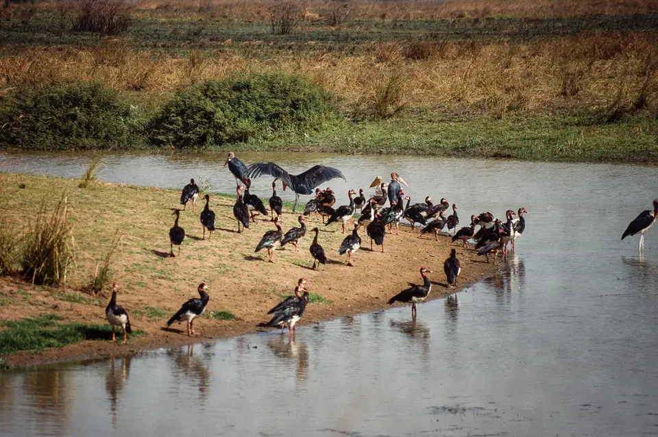
- Important Bird Area and northern floodplains waterfowl: Recognised by BirdLife International as an Important Bird Area (IBA) because it supports significant populations of numerous bird species, the park is celebrated for its northern floodplains along the Aouk, Kameur, and Gounda rivers, where seasonal wetlands attract vast congregations of resident and migratory waterfowl including spur-winged geese and marabou storks.
- Gallery forests and Sudano-Guinean transitions: Along the perennial watercourses draining north from the rugged sandstone Massif des Bongo, shaded gallery forests provide moist refuges for southern forest-dwelling mammals and birds, creating a sharp ecological contrast with the open Sudano-Sahelian grasslands of the northern border.
Poaching Pressures, the 1997 Danger Listing, and Conservation Rehabilitation
Following the 1992 conservation report submitted to UNESCO by the Haut Commissaire of the Zone Franche Ecologique, cross-border poaching by heavily armed hunters and illegal livestock grazing intensified severely across the northern savannas, wiping out rare wildlife and harvesting an estimated 80 percent of the park's large mammal populations. In early 1997, the shooting and killing of four members of the national park staff amid a general state of deteriorating regional security brought all international conservation development projects and visitor tourism to a complete halt. In 1997, following an IUCN state of conservation report prepared for the 21st session of the World Heritage Bureau in Paris, the World Heritage Committee placed Manovo-Gounda St Floris National Park on the List of World Heritage in Danger, reviewing its status at the 20th session (1997), 21st session (1998), 24th session (2001), and 25th session (2002) in Paris, recommending a comprehensive conservation assessment alongside a long-term rehabilitation strategy, and examining proposals by the government of the Central African Republic to transfer operational management of the park to an independent private conservation foundation alongside wildlife breeding programmes to revive native fauna:
- Entry and route: The unpaved Ndéle-Birao road runs directly through the heart of the park, crossing the western boundary at the Manovo River roughly 40 kilometres (25 miles) east of N'Délé in Bamingui-Bangoran province and continuing northeast across the Koumbala and Gounda basins toward Birao near the Chad and Sudan borders.
- Tickets and viewpoints: Because deteriorating security, armed poaching groups, and the halt of tourism in 1997 prevent safe civilian access, independent travel to Manovo-Gounda St Floris National Park is not currently possible; check the official site of the UNESCO World Heritage Centre and government travel advisories for updates on security and rehabilitation initiatives.
- Timing and onward connections: Conservation monitoring, anti-poaching patrols, and ecological assessments across the Manovo, Koumbala, and Gounda river watersheds and the Bamingui-Bangoran wildlife corridor take place primarily during the dry season when the northern floodplains along the Aouk and Kameur rivers recede and river crossings along the unpaved Ndéle-Birao road become passable for field vehicles and rangers.
