


























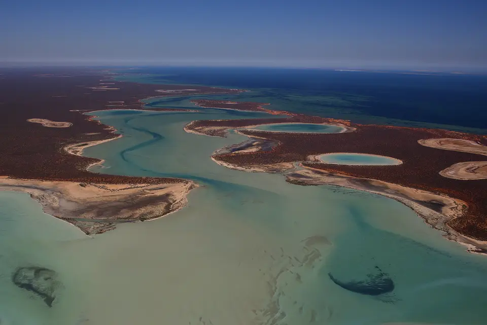
Quick Field Data
- UNESCO Inscription: 1991 under all four natural criteria (vii, viii, ix, and x) as the first World Heritage site in Western Australia, and added to Australia's National Heritage List on 21 May 2007.
- Scale & Footprint: Covering 2,200,902 hectares (roughly 2.2 million hectares or 23,000 km², of which about 70% are marine waters) across a 1,500-kilometre coastline in the Gascoyne region.
- Access & Ticketing: Denham, the Shark Bay World Heritage Discovery Centre, and the 150 km World Heritage Drive are open year-round; check park management rules for Francois Peron National Park and Hamelin Pool.
- Arrival Logistics: Located approximately 800 kilometres (500 miles) north of Perth at Australia's westernmost point, reached via the North West Coastal Highway turnoff at the Overlander Roadhouse or Shark Bay Airport.
Occupying the westernmost point of the Australian continent along the Indian Ocean coast of the Gascoyne region in Western Australia, Shark Bay (known in the Malgana language as Gathaagudu, meaning "two waters") spans a vast protected area of 2,200,902 hectares (23,000 square kilometres, or 8,900 square miles), of which approximately 70 percent consists of marine waters. Throughout Australia, the UNESCO World Heritage Atlas in 1991 under all four natural criteria (vii, viii, ix, and x) and included in Australia's National Heritage List on 21 May 2007 pursuant to the 2003 heritage legislation amendment, the region lies roughly 800 kilometres (500 miles) north of Perth. Its shallow waters, islands, and peninsulas contain some of the most extensive and species-rich seagrass meadows on Earth, a major population of dugongs, and the living stromatolites of Hamelin Pool. Salt and sun rule these shallow waters.
22,000 Years of Aboriginal Occupation and Early European Landings
The archaeological record of Australian Aboriginal occupation at Shark Bay extends back to 22,000 years BP, when most of the present bay was dry land prior to rising sea levels that flooded the basin from 8,000 BP down to 6,000 BP. Numerous Aboriginal midden sites discovered on Peron Peninsula and Dirk Hartog Island document the marine and terrestrial foods gathered across the millennia.
In 1616, an expedition led by Dutch explorer Dirk Hartog stepped ashore at Inscription Point on the northern tip of Dirk Hartog Island, becoming the second European group known to have visited Australia (following Willem Janszoon's 1606 voyage on the Duyfken to Cape York). Hartog marked his 1616 landing with an inscribed pewter plate nailed to a post; Willem de Vlamingh later replaced the plate and returned the original to the Netherlands, where it is kept in the Rijksmuseum (a replica is displayed at the Shark Bay Discovery Centre in Denham). English explorer William Dampier named Shark Bay on 7 August 1699, and subsequent voyages brought French navigator Louis Aleno de St Aloüarn (1772), followed by Nicolas Baudin (1801 to 1803) and Louis de Freycinet (1818). European pastoralists settled the area in the 1860s and 1870s alongside a pearling industry that grew rapidly from 1870, while Norwegian-owned factory ships conducted commercial whaling during the opening decades of the 20th century, taking up to 1,000 humpback whales per season in the late 1930s. At the 2011 census, fewer than 1,000 people lived across the heritage-listed area in half a dozen small communities occupying less than 1 percent of the total area (with the towns of Denham and Useless Loop specifically excluded from the boundary).
Seagrass Meadows, the Faure Sill, and Hamelin Pool Stromatolites
The bay itself covers 1,300,000 hectares (or 3,200,000 acres) and averages just just 9 metres (30 feet), bounded by more than 1,500 kilometres (930 miles) of coastline and 300 kilometres (190 miles) of limestone cliffs including the Zuytdorp Cliffs. Situated in a hot desert climate where evaporation far exceeds precipitation, Shark Bay is one of the few marine areas worldwide shaped by calcium carbonate deposits formed without reef-building corals. Over millennia, sediment and shell fragments trapped by seagrasses formed the Faure Sill and raised the sea floor, restricting tidal flow and creating hypersaline basins (1.5 to 2 times the salinity of normal seawater) as well as beaches composed entirely of shells, such as Shell Beach in L'Haridon Bight.
Seagrass meadows cover more than 4,000 square kilometres (1,500 square miles) of the bay, including the 1,030-square-kilometre (400-square-mile) Wooramel Seagrass Bank, the planet's largest continuous seagrass bank, associated with extensive limestone sand deposits precipitated from hypersaline water, and a 200-square-kilometre (77-square-mile) Posidonia australis meadow grown from a single genetic clone, the largest known plant on Earth. Twelve seagrass species have been recorded in the bay, with up to nine growing together in a single area.
- Living Stromatolites of Hamelin Pool: First identified as living modern examples in 1956 at Hamelin Pool (within Hamelin Pool Marine Nature Reserve and Hamelin Station Reserve), where cyanobacteria (blue-green algae) began building dome-shaped microbialites about 1,000 years ago at growth rates up to 250 times slower than Precambrian estimates; they represent the world's most diverse and abundant living analogue to the structures that dominated Proterozoic seas for more than 3,000 million years (with Western Australian fossils near Marble Bar dating back 3.5 billion years) and are studied for containing chlorophyll f.
- Dugongs, Dolphins, and Marine Fauna: Supporting about 10,000 dugongs (around 12.5 percent of the world's population), friendly Indo-Pacific bottlenose dolphins at Monkey Mia (famous since the 1960s, with some dolphins protecting their noses with marine sponges while foraging on the sandy bottom), migrating humpback, southern right, and Bryde's whales, nesting green and loggerhead sea turtles, whale sharks gathering during the April and May full moons, and over 323 fish species including sharks and rays.
- Protected Islands, Peninsulas, and Endangered Mammals: Encompassing Peron Peninsula, Heirisson Prong, Bellefin Prong, and Carrarang Peninsula alongside Dirk Hartog Island, Faure Island (a 5,816-hectare pastoral station (14,370 acres) acquired by the Australian Wildlife Conservancy in 1999 off Monkey Mia), Charlie Island, Friday Island, Koks Island, and predator-free Bernier and Dorre islands in the northwest, which together with Project Eden in Francois Peron National Park shelter five endangered mammal species (including two varieties of hare-wallabies) among 26 threatened Australian mammal species, over 230 bird species, and nearly 150 reptile species.
- Three IBRA Bioregions and Protected Reserves: Spanning the transition zone between three climatic regions and two botanical provinces across the Carnarvon (Wooramel CAR2), Geraldton Sandplains (Geraldton Hills GS1 at Zuytdorp Nature Reserve), and Yalgoo (Edel YAL1 on Bernier, Dorre, and Dirk Hartog islands) bioregions, managed under protected areas such as Francois Peron National Park, Shark Bay Marine Park, Hamelin Pool Marine Nature Reserve, and Zuytdorp Nature Reserve (see Management Plan No. 75 of 2012).
Navigating the 150-Kilometre World Heritage Drive
Visitors reach Shark Bay by air via Shark Bay Airport or by road along the 150-kilometre (93-mile) paved World Heritage Drive link road connecting the North West Coastal Highway turnoff at the Overlander Roadhouse with Denham on the Peron Peninsula. Along the way, stop at Hamelin Pool and Shell Beach before visiting the interactive displays at Denham's Shark Bay World Heritage Discovery Centre and continuing to Monkey Mia and Francois Peron National Park. You can explore the peninsulas, bays (Hamelin Pool, Henri Freycinet Harbour, and L'Haridon Bight), and islands on the Atlas.
Driving the 150-kilometre World Heritage Drive from the Overlander Roadhouse to Denham and exploring the twin gulfs of Gathaagudu shows how geology, climate, and marine biology interact across Shark Bay's 2,200,902 hectares. Because low rainfall, high desert evaporation, and the carbonate banks of the Faure Sill and the 1,030-square-kilometre Wooramel Seagrass Bank restrict tidal circulation across the shallow 9-metre-deep basins, the southern waters of Hamelin Pool and L'Haridon Bight reach salinities 1.5 to 2 times higher than the open Indian Ocean. These hypersaline conditions sustain both the snow-white cockle drifts of Shell Beach and the living cyanobacteria microbialites of Hamelin Pool, first recognised in 1956 as modern analogues to the stromatolites that shaped Earth's biosphere for more than 3,000 million years.
Across Australia, during this period, the 4,000 square kilometres of seagrass meadows, including the 200-square-kilometre single-clone Posidonia australis meadow and twelve coexisting seagrass species, form the foundation of a marine food web supporting 10,000 dugongs, tool-using bottlenose dolphins at Monkey Mia, migrating humpback and southern right whales, whale sharks, sea turtles, and over 323 fish species. Paired with the 300-kilometre Zuytdorp Cliffs and the predator-free island sanctuaries of Bernier, Dorre, Dirk Hartog, and Faure islands along with Project Eden in Francois Peron National Park, Shark Bay protects an unmatched coastal and marine wilderness at Australia's westernmost point.
