


























Quick Field Data
- UNESCO Inscription: 1993 (Natural, Criterion ix; Property ID 663).
- Scale & Footprint: 16,971-hectare (65.53 sq mi) wilderness tract (divided into a core zone of 10,139 ha or 39.15 sq mi and an outer buffer zone of 6,832 ha or 26.38 sq mi) within the 130,000 ha (500 sq mi) Shirakami mountain range, rising between 100 m and 1,243 m above sea level.
- Access & Ticketing: Strictly protected roadless core wilderness requiring advance permission from Forest Management to enter, bordered by accessible hiking trails in Tsugaru Quasi-National Park and Tsugaru Shirakami Prefectural Natural Park; check the official site for entry permits.
- Arrival Logistics: Located at 40.4525°N, 140.1156°E across the municipalities of Ajigasawa, Fujisato, Fukaura, and Nishimeya straddling Aomori and Akita Prefectures within northern Honshū's Tōhoku region in Japan.
Arcto-Tertiary Refugium and Heavy-Snow Climax Beech Forest
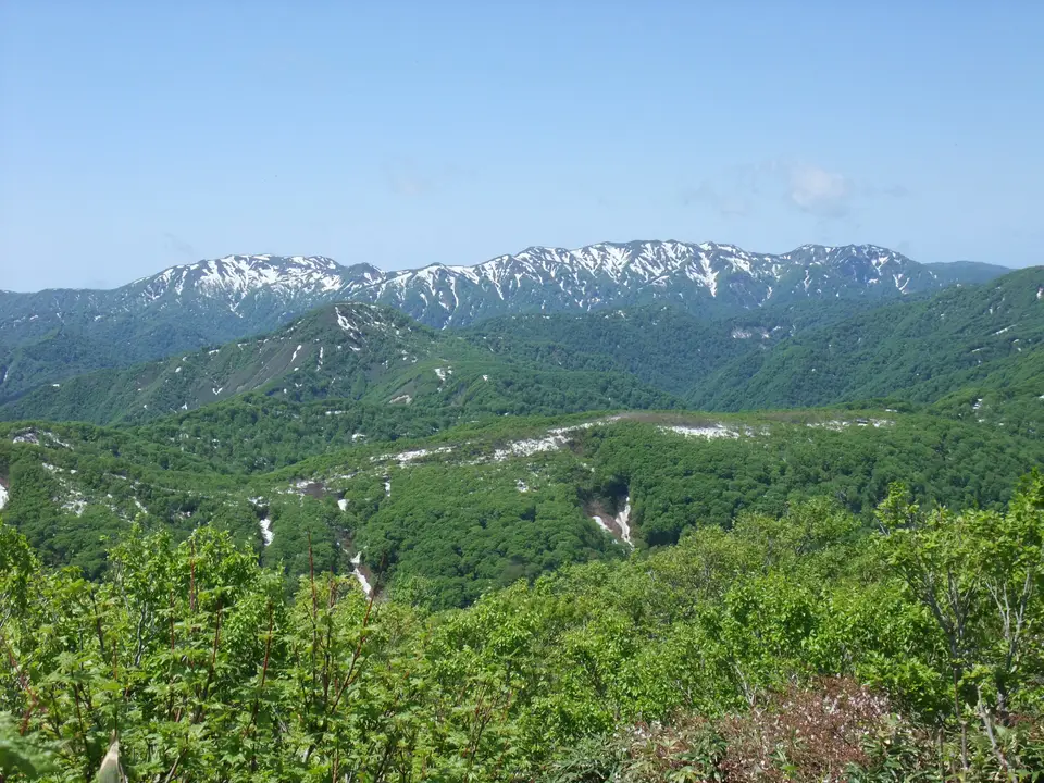
Positioned at 40.4525 degrees north and 140.1156 degrees east along the coast of the Sea of Japan within northern Honshū's Tōhoku region, the Shirakami Mountains, known in Japanese as Shirakami-Sanchi ("White God Mountains"), form a rugged, trackless mountain wilderness straddling Akita and Aomori Prefectures, with roughly three-fourths of the protected area lying inside Aomori Prefecture. Out of the wider 130,000-hectare (500 sq mi) Shirakami mountain range, a pristine tract of 16,971 hectares (65.53 sq mi), subdivided into a core wilderness zone of 10,139 hectares (39.15 sq mi) and an outer buffer zone of 6,832 hectares (26.38 sq mi) across the municipalities of Ajigasawa, Fujisato, Fukaura, and Nishimeya, was inscribed on the World Heritage List in 1993 alongside Yakushima, Himeji Castle, and the Hōryū-ji Area Buddhist Monuments as one of the first four World Heritage properties in Japan. Covering approximately one-third of the mountain range at elevations ranging between 100 metres (330 ft) and 1,243 metres (or 4,078 ft) in altitude, averaging roughly 1,000 metres (3,300 ft) above sea level, the reserve protects East Asia's largest surviving virgin beech forest as well as the last unmodified primeval forest of Japanese beech (Siebold's beech, Fagus crenata) that formerly covered the mountain slopes and hills across northern Japan.
The ecological significance of Shirakami-Sanchi stems from its paleobotanical evolution across the Quaternary ice ages. Beech (Fagus) forests across East Asia, Europe, and North America originated from circumpolar Arcto-Tertiary Geoflora prior to the continental glaciations that began reducing global beech diversity around 2 million years ago and culminated in the Last Glacial Stage. In Europe and parts of North America, mountain ranges running east to west blocked the southward retreat of circumpolar forests during glacial advances, simplifying their species composition and eliminating many ancient lineages. Along the Japanese archipelago, however, north-to-south mountain corridors allowed the circumpolar vegetation to retreat southward into southern Japan during the Last Glacial Stage while retaining its original floristic diversity, and then re-colonise the hills and slopes of northern Honshū between eight and twelve thousand years ago (also cited as 8,000 to 10,000 years ago). Consequently, the climax beech forest of Shirakami-Sanchi preserves intact elements of ancient Arcto-Tertiary Geoflora that vanished across most of the northern hemisphere, functioning as a living ecological record of pre-glacial temperate woodland composition.
Geology and winter climate reinforce this ecological stability. Underlaid primarily by granite and sedimentary rock mixed with rhyolite and quartz diorite, the Shirakami range is dissected by a maze of deep, steep-sided intersecting valleys and summits carved by six mountain rivers (the Sasauchi, Ou, Oirase, Kasuge, Akashi, and Anmon Rivers), which feed numerous mountain waterfalls. At lower altitudes, the mean annual temperature is 12 °C (corresponding to 54 °F) and average annual precipitation reaches 1,938 millimetres (76.3 in). Crucially, cold winter winds blowing across the Sea of Japan create a rare heavy-snow environment across the inland mountain slopes. Adapted to the weight and moisture of deep winter snowdrifts, the endemic Japanese beech (Fagus crenata) forms a dense, monodominant canopy over evergreen undergrowth plants that thrive beneath the insulating winter snowpack.
Seven Hundred Seed Plants, Endemic Forest Fauna, and Matagi Traditions
While commercial timber plantations of Japanese cedar have replaced much of the native broad-leaved forest across the wider Tōhoku region, the rugged topography, steep intersecting ravines, and lack of road access inside Shirakami-Sanchi prevented commercial logging and agricultural clearing. Because these hillside beech stands have never been disturbed by farmers or fragmented by timber roads, they remain in a far higher state of ecological preservation than surrounding woodlands across northern Honshū. Within the 16,971-hectare reserve, unmodified Fagus crenata stands grow in continuous, multi-aged succession across every stage of growth alongside tall deciduous companions including Katsura, Kalopanax, and Japanese Hop-hornbeam. Because these tree species, shrubs, and soil organisms interact as functional components of an undisturbed forest cycle, the reserve maintains the complete ecosystem of a stable climax cool-temperate deciduous broad-leaved forest that has disappeared across most of the temperate world. Botanists have recorded more than 700 species of seed plants across the mountain valleys and ridges, studied extensively by institutions such as Hirosaki University's Shirakami Research Center for Ecosystem Dynamics.
This undisturbed cool-temperate broad-leaved forest sustains a complete community of woodland mammals, birds, reptiles, and invertebrates that depend on old-growth tree cavities, clear headwater streams, and abundant beech mast. Characteristic mammals inhabiting the beech slopes include the Japanese black bear (Asiatic black bear), the Japanese serow (a forest-dwelling goat-antelope designated a national natural monument), the Japanese macaque, and the arboreal dormouse. Ornithological surveys have documented 87 species of birds across the mountain sanctuary, headed by the rare black woodpecker (also designated a national natural monument) and large forest raptors including the golden eagle and the mountain hawk-eagle, which nest in the tall canopy and hunt along the steep ridges.
For centuries, human interaction with the interior beech wilderness was limited to the boundary areas and the traditional practices of the Matagi people, a local Ainu-descended hunting and foraging ethnic group possessing detailed ecological knowledge of the Shirakami valleys. Operating under a strict customary hunting code, the Matagi harvested seasonal forest foods and game without altering the canopy structure, and today local Matagi guides lead low-impact eco-tours around the perimeter of the range. Grassroots conservation campaigns led by local communities, civic groups, and researchers driven by long-standing interactions with nature halted logging road construction and secured the protection of the primeval watershed as an unmodified wilderness area rare across eastern Asia.
Anmon no Taki Waterfalls, Boundary Peaks, and Wilderness Permits
Within Japan, the UNESCO World Heritage Atlas in 1993 under Natural Criterion ix and discussed by writers such as Tyler Rothmar in The Japan Times (2015), Shirakami-Sanchi is managed as a strict wilderness area whose 10,139-hectare core zone contains no roads, maintained trails, or man-made facilities. Entering the core zone requires formal advance permission from Forest Management, while visitors without core permits can experience the virgin beech ecosystem, clear mountain streams, waterfalls, and high ridges across the surrounding 6,832-hectare buffer zone and adjacent Tsugaru Quasi-National Park and Tsugaru Shirakami Prefectural Natural Park. Across the four surrounding municipalities of Ajigasawa, Fujisato, Fukaura, and Nishimeya, marked boundary footpaths allow hikers to observe the undisturbed Fagus crenata canopy without disturbing the fragile interior core. You can locate the Tōhoku mountain range between Aomori and Akita on our interactive world map. Deep winter snow shapes every beech trunk.
- Hiking to the Shadow Gate Falls (Anmon no Taki) in Nishimeya: In the western sector of Nishimeya within Tsugaru Shirakami Prefectural Natural Park, follow the river gorge trail roughly 3.5 kilometres (2.2 mi) west of Miyama Lake to view the triple cascades of the Shadow Gate Falls (Anmon no Taki) framed by steep beech slopes.
- Climbing Shirakami-dake and Tengu-dake outside the core zone: Ascend the steep trail up Shirakami-dake (rising 1,235 metres or 4,052 ft in height just outside the restricted World Heritage boundary, where no special Forest Management permit is required) or climb neighbouring Tengu-dake to look out across the unbroken canopy of Fagus crenata toward the Sea of Japan.
- Joining a Matagi eco-tour along the river valleys: Arrange a guided walk with local Matagi interpreters in the boundary municipalities of Fujisato, Fukaura, Ajigasawa, or Nishimeya to learn traditional forest foraging customs and spot Japanese macaques, Japanese serows, and black woodpeckers along the Akashi, Kasuge, Oirase, Ou, and Sasauchi watersheds.
