Quick Field Data
- UNESCO Inscription: Ref. 173 · Cultural Site · Inscribed 2000 · Criteria (ii), (iii)
- Scale & Footprint: 96-hectare Urban Conservation Area (Mji Mkongwe) occupying a western promontory on Unguja Island, holding 1,709 historic buildings west of Creek Road and its Ng'ambo buffer zone
- Access & Ticketing: Protected under the 1948 Ancient Monuments Act, 1955 Town and Country Planning Act, and 1994 Stone Town Conservation and Development Act overseen by STCDA. Winding alleyways are open on foot, while cathedrals, the Palace Museum, and the Old Fort operate independent local entry rules.
- Arrival Logistics: 8 kilometres north of Abeid Amani Karume International Airport (ZNZ) on Unguja Island, across the Zanzibar Channel from mainland Bagamoyo
Coral Ragstone Masonry, Baraza Benches, and Carved Doors
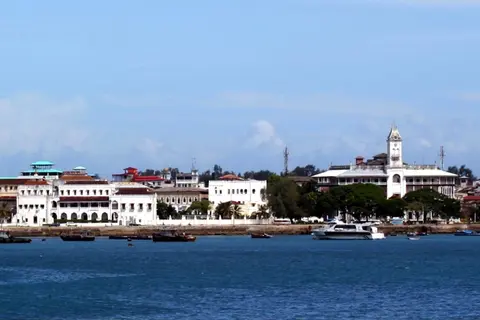
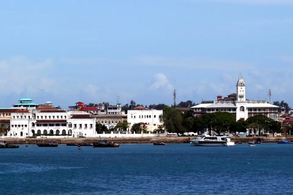
Known in Swahili as Mji Mkongwe (old town), the Stone Town of Zanzibar fills a compact 96-hectare limestone promontory jutting westward into the Zanzibar Channel on Unguja, the main island of the Zanzibar Archipelago. Immediately east of Benjamin Mkapa Road (formerly Creek Road, tracing a reclaimed tidal creek), the newer urban district of Ng'ambo (Swahili for the other side) spreads inland across the island, including the modernist Michenzani blocks and Mlandege corridor inside the UNESCO buffer zone. Inside Stone Town's conserved core, 1,709 buildings pack tightly along narrow, car-free lanes crowded by pedestrians, bicycles, and motorbikes, opening suddenly onto wider seafront boulevards facing the Indian Ocean harbour.
Physical construction materials give the entire district its warm reddish tone and distinctive structural rhythm. Builders quarried porous coralline ragstone and laid blocks in thick lime mortar bonded over mangrove timber poles called boriti, sealing exterior walls under smooth lime plaster and white or ochre lime wash. Excavations on nearby Pemba Island and at Shanga in the Lamu Archipelago trace this building sequence back through centuries of indigenous coastal innovation. Timber houses around 1050 gave way to mud-and-coral walls around 1150, mud-bonded stone by the 13th century, and lime-bonded multi-storey masonry by the 14th century. Scholars Tom Middleton and Mark Horton argue that early Swahili stone architecture evolved independently on the African coast prior to later Omani rebuilding.
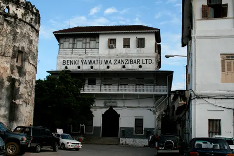
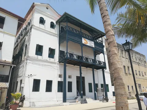
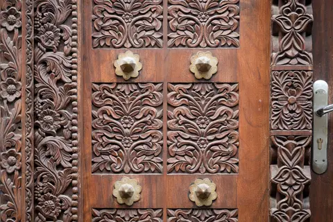
Across Stone Town's 19th-century fabric, three distinct residential and commercial forms lock together. Ground-floor thatched or coral Swahili dwellings share streets with narrow-fronted Indian duka bazaar shopfronts and grand two-storey merchant courtyard mansions. Those merchant houses arrange long, narrow rooms around shaded central courtyards reached via bent entrance passages, projecting broad carved timber verandas overhead and low built-in stone benches called barazas along ground-level walls. Barazas served simultaneously as social meeting ledges and elevated pedestrian walkways whenever heavy tropical rains flooded alleys. At entrances hang Stone Town's famous studded double wooden doors, clearly split between two maritime traditions: Omani Arab doors carry rectangular frames carved with Qur'anic calligraphy, while Indian merchant doors feature rounded arched tops studded with heavy brass bosses and carved lotus motifs symbolising prosperity.
From Shangani Fishing Village to Omani Maritime Capital
Long before stone mansions rose above the harbour, maritime trade anchored settlements across Unguja. Between the 1st and 3rd centuries CE, the Greco-Roman sailing manual Periplus of the Erythraean Sea named the island of Menuthias, widely identified with Unguja. Excavations at Fukuchani on northwestern Unguja confirm settled farming and fishing villages by at least the 6th century CE. Finds yield timber daub, shell beads, iron slag, and Gulf ceramics dated between the 5th and 8th centuries, mirroring coastal towns such as Mkokotoni and Dar es Salaam. By the close of the 10th century, Zanzibar ranked among the central Swahili trading ports of the Indian Ocean rim.
Stone Town itself began modestly in the 11th century as Shangani, a small fishing settlement overshadowed for centuries by larger island towns at Unguja Ukuu, Kizimkazi, and Tumbatu between the 8th and 16th centuries. Portuguese mariners arrived first among Europeans, occupying Unguja for over two centuries and erecting a 16th-century church at Shangani with foundations for coastal defences. In the mid-17th century Queen Fatuma of northern Unguja built a residence near the waterfront before local patricians ousted Portuguese garrisons and invited the Sultan of Oman for military protection. Completing the Old Fort (Ngome Kongwe) in 1699 around elements of the earlier Portuguese church, Omani forces stationed roughly fifty soldiers on site while local authority lingered temporarily with Queen Fatuma (the Mwinyi Mkuu).
Stone houses multiplied from the early 1800s onward, accelerating dramatically in 1824 when Sultan Said bin Sultan shifted the Omani royal seat from Muscat directly to Stone Town, turning Zanzibar into the capital of a combined Sultanate of Oman and Zanzibar. Clove commerce and East Africa's Indian Ocean slave trade poured immense wealth into the harbour, drawing Omani, Persian, and Indian merchant communities who raised grand courtyard residences and civic landmarks. Even as British anti-slavery treaties disrupted Muscat's economy and Britain's explorer David Livingstone prepared his final interior expedition while staying in Stone Town in 1866, Zanzibar became an independent sultanate in 1861 under Sultan Majid bin Said following a succession dispute.
Imperial power shifted sharply during the late 19th century. After mainland East African territories slipped to Germany and Britain, the 1890 Heligoland-Zanzibar Treaty placed Zanzibar under a British protectorate. British administrators expanded a local line into the Bububu village railway while favouring Dar es Salaam and Mombasa as mainland ports. When an Omani succession crisis triggered rebellion in 1896, Royal Navy warships bombarded Stone Town for 45 minutes on 27 August 1896 in what history records as the shortest war ever fought. The shelling shattered the waterfront lighthouse and adjacent Beit al-Hukum palace. Decades later, the 1964 Zanzibar Revolution toppled the sultanate amid severe bloodshed, with over 20,000 killed and widespread flight of Arab and Indian families. Tanganyika and Zanzibar subsequently united into the United Republic of Tanzania, with Stone Town remaining the semi-autonomous islands' local seat of government.

Seafront Palaces, Bazaars, and Preservation Pressures
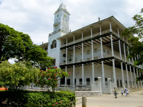
Facing Forodhani Gardens along Mizingani Road stands Stone Town's monumental waterfront sequence between the 1699 Old Fort and the Palace Museum (formerly Beit al-Sahel). Built in 1883 for Barghash bin Said, second Sultan of Zanzibar, the towering 39-metre-tall, 50-by-50-metre ceremonial palace is known locally as Beit al-Ajaib. One of six palaces he erected, it stands traditionally on the 17th-century palace site of Queen Fatuma and is widely attributed to a British marine engineer. The building introduced unprecedented architectural forms to East Africa: coral rag walls reinforced with concrete slabs, steel beams, boriti mangrove shoots, and wide cast-iron columned verandas supporting lofty ceilings around a central covered atrium. Interiors featured open galleries, imported European marble floors, silver interior detailing, Zanzibar's first electric lighting, and East Africa's first elevator. Overhead covered passages called wikios originally connected Beit al-Ajaib discreetly to the adjacent Beit al-Hukum and Beit al-Sahel palaces so royal women could move between complexes unseen from street level. Two 16th-century Portuguese bronze cannons captured by Persians in 1622 and brought by Omani sultans guard the broad entrance, with the largest bearing the emblem of King John III of Portugal. Local tradition holds the doorway was sized wide enough for the Sultan to ride an elephant through while wild animals stood tethered outside. Repaired after minor 1896 bombardment damage with a new 1897 facade clock tower (while ruined Beit al-Hukum became an open garden), the building served as British government offices and secretariat in 1911. After 1964 it housed Afro-Shirazi Party school and museum facilities aided by North Korea. Exhibits launched between 1992 and 1994 featured a sewn-plank mtepe boat, Swahili fishing gear, ceremonial kangas, portraits of Sultanic figures and trader Tippu Tip, East African biome displays, and President Abeid Karume's ground-floor car. Severe structural setbacks followed as veranda and roof sections collapsed in 2012 and 2015, forcing exhibits to relocate. On 25 December 2020 during Oman-funded renovation, much of the front facade and clock tower fell in, trapping construction workers (four rescued, two killed) ahead of reconstruction planned from archival drawings.
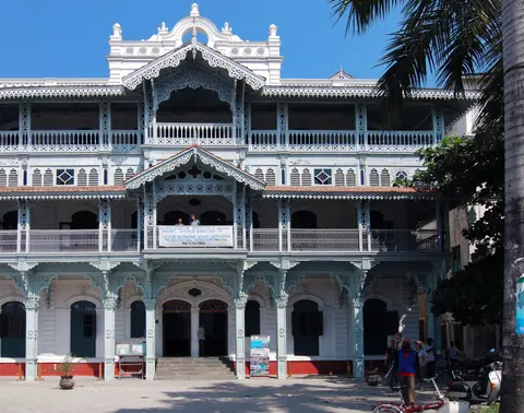
Inland lanes preserve an extraordinary cross-section of faith and civic heritage across compact blocks. Christ Church Anglican Cathedral rises directly over the site of Zanzibar's last public slave market, honouring David Livingstone and the final abolition of East African slave trading. Nearby stand St Joseph's Roman Catholic Cathedral, the Malindi Bamnara Mosque, the Ismaili Jamat Khan, the Royal Cemetery, the Hamamni Persian Baths, the restored Indian-carved Old Dispensary, Tippu Tip's former residence, and Kiponda's Art Deco Cine Afrique.
Conserving friable coral stone poses relentless technical demands across multiple agencies. Statutory backing rests on the 1948 Ancient Monuments Act, 1955 Town and Country Planning Act, 1985 Urban Conservation Area designation under the Stone Town Conservation and Development Authority (STCDA), the 1994 Act, and the 2007 Management Plan. Joint oversight includes the Department of Museums and Antiquity, Department of Housing and Human Settlement, and Commission of Waqf. Even so, surveys estimate roughly 80 percent of Stone Town's 1,709 buildings exhibit structural deterioration without continuous lime-mortar upkeep. Major seafront restorations guided by the Aga Khan Trust for Culture (AKTC) anchor best-practice repair using traditional laterite sand, lime, and coral stone. Yet UNESCO monitors warn against modern cement substitutes, rising traffic congestion, tourism accommodation conversion, and unapproved port expansion at Malindi Port where two historic warehouses were lost.
Urban Districts and Monument Access Across Mji Mkongwe
Walking remains the sole practical way to navigate inner bazaar streets too tight for four-wheeled cars, connecting wider seafront lawns with shaded interior residential quarters.
| Complex Zone | Key Highlights | Access & Ticket Rule |
|---|---|---|
| Mizingani Seafront & Forodhani Gardens | Old Fort (1699), Palace Museum (Beit al-Sahel), and fenced Beit al-Ajaib restoration perimeter | Seafront promenade and gardens are open freely; individual museum interiors set local entrance fees on site |
| Bazaar Streets & Creek Road Border | Indian duka shopfronts, Old Dispensary facade, and historical Darajani market boundary | Busy pedestrian and motorbike commercial lanes open freely; respect active shops and local mosque prayer dress norms |
| Cathedral & Historic Quarter | Christ Church Anglican Cathedral on last slave-market ground, St Joseph's Cathedral, and Hamamni Persian Baths | Guided cathedral heritage tours carry separate entry fees checked locally at church gates |
| Shangani & Kiponda Alley Maze | Early fishing settlement core, Tippu Tip house, Cine Afrique cinema, and baraza-lined merchant lanes | Car-free residential footpaths open continuously; ask permission before photographing occupied private doorways |
Three Architectural Details Along the Stone Alleys
Slowing down along Stone Town's narrower side streets lets observant walkers pick out three physical hallmarks of Swahili coastal building craft.
- Omani Rectangular vs Indian Arched Studded Doors: Pause at merchant entrances in Shangani and Bazaar quarters to compare flat-lintel Omani doors carved with floral borders and Qur'anic scripts against curved Indian doors. The Indian frames carry projecting brass spikes originally designed to deter war elephants back in South Asia.
- Raised Street-Side Stone Barazas: Notice continuous plastered masonry benches flanking ground-floor walls along narrow alleys. Beyond offering cool evening seating for residents, those raised ledges function as dry elevated pavements when seasonal monsoon downpours turn narrow coral-stone lanes into drainage channels.
- Exposed Coral Ragstone and Boriti Ceiling Poles: Wherever plaster flakes away on weathered upper walls, look closely at the honeycomb texture of fossilised marine coral chunks held in pale lime mortar and supporting round mangrove boriti ceiling joists spaced closely to span narrow courtyard rooms.
Walk interior alleys early in the morning or late afternoon when stone overhangs throw welcome shade across lanes and sea breezes cool Forodhani Gardens, remembering to inspect restoration updates around Beit al-Ajaib locally. Connect Unguja's Indian Ocean heritage with mainland Tanzanian capitals via our Dodoma travel guide or explore more coastal trading towns inside the UNESCO World Heritage Atlas.