


























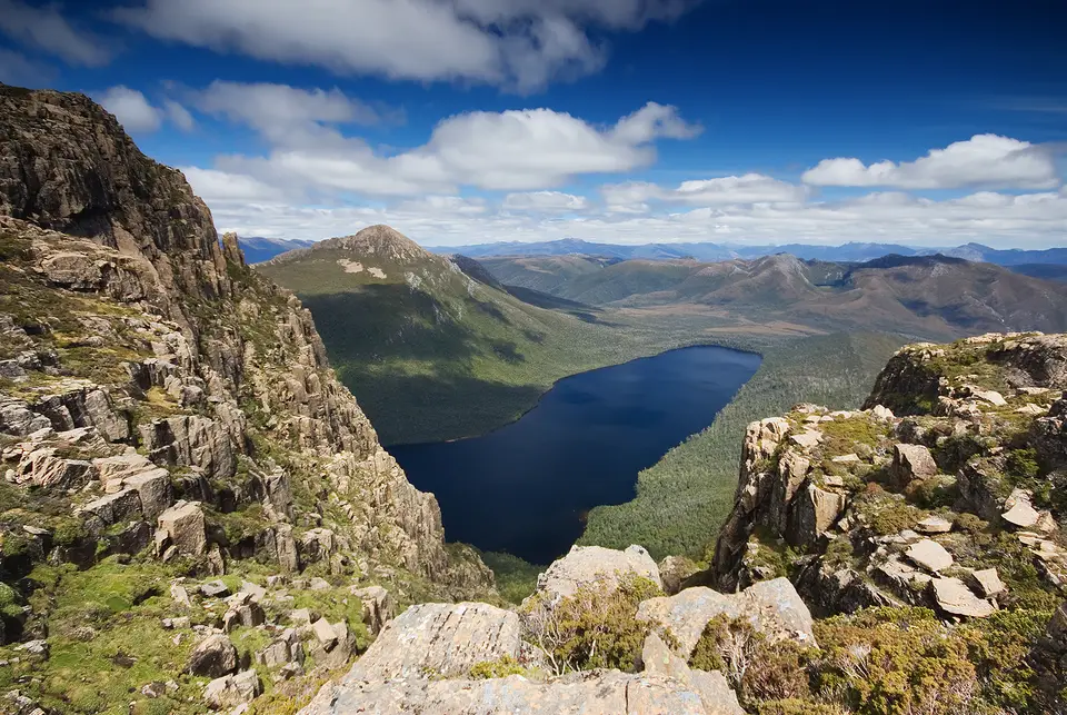
Quick Field Data
- UNESCO Inscription: 1982, extended in 1989 and 2013 (Mixed natural and cultural heritage property across southern, western, and central Tasmania, Australia, meeting 7 of the 10 World Heritage criteria)
- Scale & Footprint: 1,584,233 hectares (15,800 square kilometres or 6,100 square miles), encompassing nearly 25 percent of the island State of Tasmania across a 200-by-70-kilometre wilderness belt
- Access & Ticketing: Jointly managed by the Tasmanian Parks and Wildlife Service and the Australian federal government; check the official site for mandatory national park passes, highland walking track permits, and "leave no trace" bushwalking rules
- Arrival Logistics: Peripheral road gateways enter at Cradle Mountain and Lake St Clair on the Central Plateau, Mt Field in the eastand the western and southern forest margins
Glaciated Quartzite Ranges, the Franklin Dam Battle, and Seven UNESCO Criteria
Spanning 1,584,233 hectares, roughly 15,800 square kilometres (6,100 square miles), or nearly a quarter of the entire island State of Tasmania, which itself measures 296 kilometres north to south and 315 kilometres east to west across the Bass Strait some 300 kilometres south of mainland Australia, the Tasmanian Wilderness World Heritage Area (TWWHA) protects one of the largest expanses of temperate wilderness remaining on Earth. First inscribed on the UNESCO World Heritage Atlas in 1982 across 1.38 million hectares and expanded in 1989 by 600,000 hectares and again in 2013 to its present footprint extending 200 kilometres north to south by an average of 70 kilometres east to west, the reserve satisfies seven out of the ten UNESCO World Heritage assessment criteria (three cultural and four natural), a distinction shared globally only with Mount Tai in China.
The creation of the World Heritage Area emerged from one of the most consequential environmental campaigns in Australian history. In the early 1980s, fierce public opposition erupted over plans to construct the Franklin Dam, a major hydroelectric scheme that would have flooded the wild river gorges of southwestern Tasmania. Following the 1982 World Heritage inscription, the Australian federal government intervened under its international treaty obligations to halt construction of the dam. Seven years later, following the Helsham Inquiry into protecting tall old-growth eucalypt forests from commercial logging, the protected area was substantially enlarged in 1989 across the Central Plateau and eastern forest margins, supported by increasing management budgets that rose from around 1 million Australian dollars at the start of the 1980s to 3 million mid-decade, 9 million in the mid-1990s, and 11 million in 2008, alongside comprehensive management plans adopted in September 1992 (reviewed under Dr. Helen Hocking) and March 1999, and the rejection during the 38th Session of the UNESCO World Heritage Committee held in Doha, Qatar, in June 2014 (and subsequent 2016 withdrawal) of a federal proposal to de-list forest tracts for logging.
Geologically and climatically, the TWWHA unites Tasmania's four largest national parks and adjacent reserves: Cradle Mountain-Lake St Clair National Park, Franklin-Gordon Wild Rivers National Park, Southwest National Park (where Lake Judd sits beneath Mount Eliza), Walls of Jerusalem National Park, Hartz Mountains National Park, Mt Field National Park, Mole Creek Karst National Park, Devils Gullet State Reserve, the Central Plateau Conservation and Protected Areas, and South East Mutton Bird Islet. Although the highest peaks reach only around 1,600 metres, or 5,000 feet, in elevation without permanent year-round snowfields, repeated Pleistocene glaciations, the last of which retreated 10,000 to 12,000 years ago, carved serrated quartzite and dolerite ridges, deep glaciated valleys, hanging cirques, tarns, and extensive limestone karst cave systems, while the Darwin Crater preserves the longest continuous Pleistocene pollen record in Australia. Swept by the moisture-laden roaring forties of the Southern Ocean under a cool temperate maritime climate (Köppen Cfb, with recorded extremes at the 2004 Warra weather station and across the reserve ranging from 87.6 millimetres of rain on 10 August 2007 and −4.3 degrees on 13 September 2013 to 37.4 degrees on 31 January 2020), the west coast feeds wild tannin-stained rivers and undisturbed rocky shorelines fringed by giant kelp forests and temperate seagrass beds.
Palaeoendemic Flora, Rare Fauna, and Forty Millennia of Aboriginal Heritage
Situated within the Australasian biogeographical domain and isolated from mainland Australia by Bass Strait, the Tasmanian Wilderness functions as a living evolutionary refuge for ancient ancient Australasian plant and animal lineages that vanished elsewhere as the Australian continent dried. Across six major ecosystem groups, cool temperate rainforest, tall wet sclerophyll eucalypt forest, alpine and subalpine treeless moorlands with unusual scleromorphic shrubs adapted to a maritime climate, buttongrass moorlands, and alkaline and estuarine wetlands, ancient conifers such as ancient native conifers and deciduous beech thrive alongside towering mountain ash eucalypts.
Faunal surveys across the TWWHA have documented 1,397 animal species representing 293 families, spanning 30 terrestrial mammal species, 120 terrestrial bird species, 14 reptile species, seven frog species, 16 freshwater fish species, and 68 marine fish species. Endemic and restricted-range vertebrates include the Moss Froglet, discovered in the southwest moorlands, and the Pedra Branca Skink on offshore rocky islets, alongside marsupial carnivores, wombats, platypuses, and breeding colonies of seabirds and migratory orange-bellied parrots. Equally significant is the primitive invertebrate fauna of the wet forest litter, caves, and alpine streams, with 904 Uniramia species, 179 Chelicerata species, 90 Aschelminthes species, 88 Crustacea species, 69 Mollusca species, 57 Annelida species, eight species of Platyhelminthes, and Onychophora and Nemertea.
Intertwined with these natural ecosystems is a profound cultural landscape shaped by Tasmanian Aboriginal people across approximately 35,000 to 40,000 years, spanning a complete glacial-interglacial climatic cycle during which Aboriginal Tasmanians were the southernmost human population on Earth throughout the last ice age. Excavations in remote limestone caves along the western river valleys have uncovered rich Pleistocene occupation deposits dating back more than 20,000 to 35,000 years, filled with flaked stone and bone tools, wallaby hunting remains, and cave rock markings including red ochre hand stencils that testify to enduring spiritual beliefs. Along the rugged coast and estuaries survive Holocene shell middens, rock shelters, and stone arrangements, while millennia of deliberate Aboriginal fire-stick farming sculpted the open buttongrass plains and forest mosaics before colonial British policies implemented through George Augustus Robinson in the 1830s forcibly removed Indigenous communities from the interior.
Bushwalking the highland walking track, Wild Rivers, and Peripheral Gateways
With virtually no permanent human residents inside its 1.58-million-hectare boundary and very few penetrating roads, the Tasmanian Wilderness attracts around 500,000 visitors annually while concentrating day-use facilities at well-managed peripheral hubs to preserve the roadless core of the South West Wilderness as Australia's premier bushwalking, climbing, and whitewater rafting sanctuary. Rain and snow can fall in any season.
- Cradle Mountain-Lake St Clair and the Walls of Jerusalem: Enter the northern glacial highlands at Cradle Mountain to walk the boardwalks around the glacial lakes beneath the jagged dolerite crags, or set out on the multi-day highland walking track south through alpine moorlands, cushion plants, and rainforest to Australia's deepest glacial lake at Lake St Clair. Experienced self-sufficient walkers can also hike into the roadless subalpine basins and native conifer groves of the adjacent Walls of Jerusalem National Park or explore the limestone caverns of Mole Creek Karst National Park.
- Franklin-Gordon Wild Rivers and the West Coast waterways: Follow the highway corridor bisecting Franklin-Gordon Wild Rivers National Park to walk short temperate rainforest trails and view the glaciated river valleys. From the western coast, boat cruises and multi-day whitewater rafting expeditions navigate the dark tannin-stained waters and steep limestone gorges of the wild rivers.
- Mt Field, Hartz Mountains, and Southwest National Park: Along the eastern margin, walk beneath giant eucalypts and tree ferns to the waterfalls and the alpine tarns of Mt Field National Park, or climb the glaciated dolerite ridges of Hartz Mountains National Park. For a view into the vast roadless interior of Southwest National Park, access the peripheral lakes or hike along the southern ocean coast, while remote peaks such as Mount Eliza overlooking Lake Judd remain the domain of multi-day expedition bushwalkers, climbers, and light aircraft flights. Joint governance between the Australian federal government and the State of Tasmania, administered by the Tasmanian Parks and Wildlife Service alongside the Ministerial Council, the standing committee, and the Consultative Committee, ensures that conservation outcomes, fire management, ecological monitoring from the inaugural 2004 ecological conservation report for the World Heritage Area onward, and the protection of Pleistocene and Holocene Aboriginal cultural sites remain balanced across all ten national parks and reserves.
