


























Quick Field Data
- UNESCO Inscription: 1991 (15th session) under natural criteria vii, ix, and x across two contiguous wildlife sanctuaries in western Thailand.
- Scale & Footprint: Encompassing 622,200 hectares (over 600,000 ha) along the Myanmar border across Kanchanaburi, Tak, and Uthai Thani provinces.
- Access & Ticketing: Designated as IUCN Category Ia strict wildlife sanctuaries under the Wildlife Conservation Office; public access is limited and prohibited zones require prior permission from the Conservation Office in Bangkok and the sanctuary chief.
- Arrival Logistics: Located in western Thailand near the provincial hub of Tak and reached via road routes northwest from Bangkok.
Stretching across 622,200 hectares (more than 600,000 hectares) along the Myanmar border in Uthai Thani, Tak, and Kanchanaburi provinces of western Thailand, the Thungyai-Huai Kha Khaeng Wildlife Sanctuaries form the largest protected wilderness complex in Mainland Southeast Asia and remain among the least disturbed forest territories in Thailand. For Thailand, the UNESCO World Heritage Atlas in 1991 under natural criteria vii, ix, and x, the site combines two contiguous reserves: Huai Kha Khaeng Wildlife Sanctuary, separately established in 1972, and Thung Yai Naresuan Wildlife Sanctuary (Thungyai Naresuan), established in 1974. Together they preserve intact intact representations of nearly every forest ecosystem found across continental South-East Asia. Steep ridges guard the valleys.
Establishment in 1972 and 1974, Boundary Expansions, and Village Relocations
Huai Kha Khaeng Wildlife Sanctuary was formally established on 4 September 1972 (published in Royal Gazette Issue 89, chapter 132), initially covering an area of 1,019,375 rai, or approximately 1,631 square kilometres (630 square miles). Two years later, in 1974, the adjoining Thung Yai Naresuan Wildlife Sanctuary was established along the western frontier. To strengthen habitat connectivity and watershed protection, Huai Kha Khaeng was subsequently expanded twice by royal decree: first on 21 May 1986 (Royal Gazette Issue 103, chapter 87) by an increase of 589,775 rai (943 square kilometres, or 364 square miles) to reach 1,609,150 rai (2,574 square kilometres, or 994 square miles), and a second time on 30 December 1992 (Royal Gazette Issue 109, chapter 126) by adding 718,212 rai (or 1,149 square kilometres, or 444 square miles) to reach 1,737,587 rai, or roughly 2,780 to 2,822.08 square kilometres (1,070 square miles).
During the early years after 1972, several indigenous Karen and Hmong villages still stood inside the sanctuary boundaries. In 1976, Karen villages in the southernmost sector were relocated southeast to Ban Rai District, and a Hmong village in the western sector was moved after the 1986 expansion, leaving the wildlife sanctuary with no permanent human population inside its core forest zones.
Folded Mountain Landforms, Peak Elevations, and Four Biogeographic Affinities
Straddling the Shan and Thai folded mountains and three distinct landforms, the sanctuaries feature parallel mountain ridges running from north to south that rise well above 1,500 metres. The tallest summit, Thung Yai, rises to 1,830 metres in elevation, whereas numerous interior valley bottoms slope from 400 metres down to 250 metres above sea level. Across these steep-sided valleys and small lowland plains flow tributary streams and waterfalls interspersed with limestone habitats, wetlands, sink-holes, and natural mineral-licks that sustain complex ecological and biological processes.
Because the reserve sits at a continental crossroads, its flora and fauna bring together associations found nowhere else, mingling flora and fauna from Indo-Burmese, Sino-Himalayan, Indo-Chinese, and Sundaic biogeographic regions within a single contiguous forest mosaic. Scientific studies, including 2014 research published in the Proceedings of the Royal Society B (volume 282, issue 1798) examining how the loss of animal seed dispersal affects tropical tree species across life stages, highlight the sanctuary's importance as a benchmark where large-mammal ecological processes still function intact, even as some regional species such as rhinoceroses have disappeared or declined across mainland Southeast Asia.
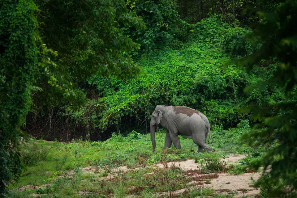
- Indochinese Tigers and Large Mammals: Home to 77 percent of the large mammals found in continental South-East Asia (and roughly one-third of all Southeast Asian mammal species), including viable populations of Asian elephants, gibbons, bears, and 90 wild Indochinese tigers recorded within Huai Kha Khaeng.
- Three National Reserved Wildlife Species of Thailand: The sanctuary plays a primary conservation role for three of Thailand's National Reserved Wildlife Species: the wild water buffalo (Bubalus arnee), Indian hog deer (Hyelaphus porcinus), and mainland serow (Capricornis sumatraensis).
- 355 Recorded Bird Species and Land Vertebrates: Protecting 50 percent of the region's large birds and 33 percent of its land vertebrates, with sightings of 355 bird species documented inside Huai Kha Khaeng alongside diverse reptiles and amphibians.
- Limestone Habitats, Sink-Holes, and Mineral-Licks: Specialized valley and ridge habitats spanning from 250-metre valley floors to the 1,830-metre peak of Thung Yai, creating seasonal foliage variations and year-round water and mineral sources for forest wildlife.
Research Governance, Dry-Season Access, and Visitor Logistics
Administered by the Wildlife Conservation Office as an IUCN Category Ia protected area (Protected Planet profile 1407), Huai Kha Khaeng and Thungyai Naresuan prioritise strict ecological protection and scientific research over mass recreation. Most visitors arrive during the summer or dry season, when dirt access roads and forest trails are passable. Many interior sections of the sanctuary are closed to the general public; anyone wishing to enter restricted research zones must obtain formal written permission in advance from the Huai Kha Khaeng sanctuary chief together with the Wildlife Conservation Office in Bangkok.
Travellers driving northwest from Bangkok toward Uthai Thani, Kanchanaburi, or the nearest city of Tak can visit the designated public education and nature-trail areas along the sanctuary perimeter. You can examine the mountain-and-valley geography of the Myanmar border reserves on the Atlas. Always check current seasonal access rules with the Wildlife Conservation Office before planning a journey.
Because Thungyai Naresuan and Huai Kha Khaeng span 622,200 hectares of contiguous mountain ridges and river valleys along the Myanmar frontier, they preserve ecological processes that have vanished from smaller, fragmented forest reserves across mainland Southeast Asia. Rising from valley bottoms at 250 to 400 metres above sea level to parallel north-south mountain crests exceeding 1,500 metres and culminating at the 1,830-metre summit of Thung Yai, the two sanctuaries shelter a complex mosaic of dry dipterocarp woodlands, mixed deciduous forests, evergreen gallery forests, limestone habitats, wetlands, sink-holes, and natural mineral-licks. This topographic and climatic variety allows species from four distinct biogeographic zones, Indo-Burmese, Sundaic, Sino-Himalayan, and Indo-Chinese, to coexist within a single protected wilderness.
For conservation biologists, the survival of 90 wild Indochinese tigers alongside Asian elephants, bears, gibbons, and three of Thailand's National Reserved Wildlife Species, namely the wild water buffalo (Bubalus arnee), the Indian hog deer (Hyelaphus porcinus), and the mainland serow (Capricornis sumatraensis), demonstrates the value of the boundary expansions enacted in 1986 and 1992 and the relocation of interior villages in 1976 and after 1986. With 77 percent of continental Southeast Asia's large mammal species, 50 percent of its large birds (with 355 bird species recorded in Huai Kha Khaeng), and 33 percent of its terrestrial vertebrates thriving inside the reserve, the sanctuaries function as a vital living laboratory for studying predator-prey dynamics and animal seed dispersal in seasonal tropical forests.
Visitors who travel from Bangkok to the designated public nature trails and educational centres near Uthai Thani, Kanchanaburi, and Tak during the dry season gain a rare window into Thailand's most intact western forest landscape, while strict IUCN Category Ia protections and permit controls administered by the Wildlife Conservation Office safeguard the remote interior valleys. Walking the marked perimeter trails at dawn or dusk reveals how tributary streams, mineral springs, and mixed deciduous canopies sustain birds, primates, and ungulates across the changing monsoon and dry seasons without disturbing the core sanctuary zones.
The hydrological importance of the two adjoining reserves is equally significant for western Thailand. Fed by southwest monsoon rains between May and October and cooler northeast winds from November to April, the mountain headwaters rising inside Thungyai Naresuan and the Huai Kha Khaeng river valley regulate downstream water supplies across Kanchanaburi, Tak, and Uthai Thani provinces. Along the permanent river corridors, evergreen gallery forests shelter wild elephants, tapirs, otters, and hornbills during the dry months from November to April, when surrounding hill slopes shed their leaves and seasonal fires sweep through the dry dipterocarp savannahs. By protecting both the high-altitude evergreen catchments and the low-lying riverine wetlands within one unbroken boundary, the sanctuaries maintain the natural seasonal rhythms upon which mainland Southeast Asia's rarest forest wildlife depends.
