


























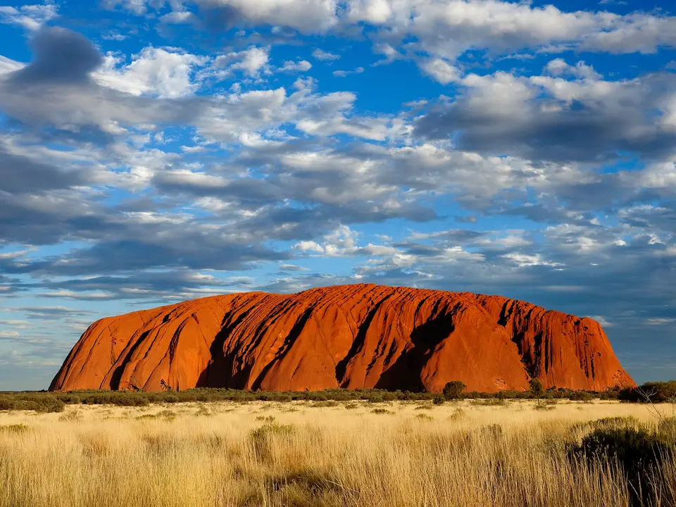
Quick Field Data
- UNESCO Inscription: 1987 (extended 1994 for cultural landscape values) · Criteria (v), (vi), (vii), (viii).
- Scale & Footprint: 1,326 to 1,333.72 square kilometres in the Petermann region of the Northern Territory, central Australia, surrounded by the 50,000-square-kilometre Katiti Petermann Indigenous Protected Area
- Access & Ticketing: Jointly managed by the Anangu traditional owners and the Director of National Parks; three-day visitor passes grant access between sunrise and sunset (with one quarter of fees returned to the Anangu community), while climbing Uluru has been permanently banned since October 2019
- Arrival Logistics: Located 440 kilometres southwest of Alice Springs and 1,943 kilometres south of Darwin along the Stuart and Lasseter Highways (part of the Outback Highway), served by Connellan Airport and accommodation outside the park at Yulara
Arkose Sandstone Monoliths alongside Conglomerate Domes and the Alice Springs Orogeny
Spanning 1,326 to 1,333.72 square kilometres (512 square miles) across the red sandplains of the Petermann sub-region in Australia's Northern Territory, Uluru-Kata Tjuta National Park protects two monumental desert rock formations separated by 40 kilometres (25 miles) of spinifex dunes: the 348-metre-high (1,142-foot) sandstone monolith of Uluru (Ayers Rock) in the east, and the 36 steep-sided rock domes of Kata Tjuta (Mount Olga) in the west. First excised from the Petermann Aboriginal Reserve as a national park in 1950 and 1958, the reserve was inscribed on the World Heritage List in 1987 for its geological and ecological features under criteria (vii) and (viii), and extended in 1994 under criteria (v) and (vi) as one of the world's premier associative cultural landscapes. On 1 October 2015, traditional owners further declared over 50,000 square kilometres of surrounding Aboriginal freehold land as the Katiti Petermann Indigenous Protected Area (IPA), the fourth-largest IPA on mainland Australia.
Both Uluru and Kata Tjuta owe their existence to a 500-million-year geological sequence of mountain erosion alongside inland sea sedimentation and tectonic folding during the Alice Springs Orogeny roughly 350 million years ago. Around 500 million years ago, an inland sea covered central Australia, receiving vast alluvial fans of sand alongside mud plus cobbles and boulders eroded from ancient granite and basalt mountain ranges. Whereas the western deposits consolidated into a coarse sedimentary conglomerate of granite and basalt boulders cemented by a sandstone matrix that eroded into the 36 domes and water-carved crevasses of Kata Tjuta, the eastern fan formed a homogeneous, coarse-grained, mineral-rich sandstone known as arkose. During the Alice Springs Orogeny 350 million years ago, tectonic compression tilted the arkose sandstone beds nearly ninety degrees onto their vertical edge and folded the conglomerate beds of Kata Tjuta; subsequent millions of years of erosion stripped away softer surrounding strata, leaving the vertical arkose ribs of Uluru standing 348 metres above the plain while the vast majority of its rock mass plunges kilometres underground. Iron oxidation gives the arkose its rust-red surface colour.
In an arid continental desert that receives an average annual rainfall of 307.7 millimetres and experiences temperature extremes from minus 5 degrees on winter nights to 45 degrees on summer days (with summer UV readings reaching 11 to 15), the massive rock domes act as hydrological collectors. Sudden desert rainstorms cascade down the smooth arkose and conglomerate faces in temporary waterfalls, recharging permanent waterholes and moist micro-habitats around the bases of the monoliths where rare adder's tongue ferns (Ophioglossaceae) and four species of desert frogs survive.
Anangu Tjukurpa Law alongside the 1985 Handback and Arid-Zone Ecology
For the Anangu, the traditional Aboriginal owners who have inhabited the Western and Central Deserts for more than 10,000 years, Uluru and Kata Tjuta are not merely geological curiosities; they are living physical manifestations of Tjukurpa, which encompasses traditional sacred law and knowledge plus philosophy and creation stories passed down through song (Inma) alongside ceremony and oral tradition by elders such as Tony Tjamiwa. Every fissure alongside each waterhole plus cave and stain on the rock face of Uluru records the actions of ancestral beings during the creation period, including the Mala (rufous hare-wallaby people) alongside the Kuniya (woma python) and the Liru (poisonous snake), while Kata Tjuta (meaning many heads) is a site of powerful sacred knowledge restricted to initiated men. Traditional Anangu ecological calendars divide the desert year into six distinct seasons: Piryakatu (August and September, when plants flower and animals breed), Wiyaringkupai (October and November, the hot season), Itanju (January and February, marked by sudden summer electrical storms), Wanitjunkupai (March cooler weather), Tjuntalpa (April and May southern clouds), and Wari (June and July winter frosts).
European contact began in 1872 after construction of the Overland Telegraph Line, when explorer William Ernest Powell Giles sighted Kata Tjuta and named it Mount Olga, and the following year William Christie Gosse named Uluru after South Australian Chief Secretary Sir Henry Ayers. Following late-nineteenth-century pastoralist conflicts alongside establishment of the South-Western (Petermann) Reserve in 1920, the arrival of the first tourists in 1936, construction of a vehicle track in 1948, and early tent tours launched by Alice Springs resident Len Tuit in 1955 alongside first park ranger Bill Harney in 1958, unregulated motels and campgrounds clustered directly against the base of Uluru. To halt environmental degradation, the government approved a 104-square-kilometre resort and airport zone 15 kilometres north of Uluru outside the park boundary in 1975 (now Yulara and Ayers Rock Resort) and closed the internal park campgrounds and motels in 1983 and 1984. Following the Aboriginal Land Rights (Northern Territory) Act 1976, the Australian Government formally returned the freehold title deeds of the park to the Anangu traditional owners on 26 October 1985, who leased the park back to the Director of National Parks for 99 years under a pioneering joint-management board.
Joint management combines scientific ecology with traditional Anangu land stewardship across four plant categories: Punu (trees such as mulga alongside centralian bloodwood plus river red gum and corkwood grevilleas and hakeas), Puti (shrubs such as the witchetty bush), Tjulpun-tjulpunpa (daisies and wattles), and Ukiri (grasses, led by deep-rooted spinifex hummocks whose heated resin yields black hunting gum, alongside naked woollybutt and native millet ground into damper flour, while park crews battle 34 invasive exotic weeds led by perennial buffel grass, Cenchrus ciliaris). After the suspension of traditional winter patch-burning in the 1930s allowed heavy fuel buildup that caused lightning wildfires to burn one-third of the park in 1950 and 76 percent of the park in 1976 (followed by severe fires in 2002), joint management restored traditional Anangu winter fire-management regimes.
That habitat management protects 73 recorded reptile species (including the vulnerable great desert skink alongside the woma python or kuniya plus the perentie and the sand goanna), seven bat species roosting in rock crevices, desert birds such as the pied butcherbird alongside the black-breasted buzzard plus the black-faced woodswallow and crimson chat, and 21 surviving native mammal species (down from 46 historically due to introduced foxes and cats plus camels alongside dogs and house mice as well as rabbits, the latter curbed by a 1989 rabbit control programme supported by Anangu trackers). Vulnerable sandplain species between Uluru and Yulara include the mulgara and marsupial mole, and reintroduction efforts for the mala (rufous hare-wallaby) plus the bilby alongside the burrowing bettong and black-footed rock wallaby as well as the brushtail possum and mallee fowl.
Walking the Base of Uluru and the Valley of the Winds at Kata Tjuta
Because the Uluru climb crossed the sacred path of the ancestral Mala men, the joint-management board voted unanimously in November 2017 to end climbing, and ascending the monolith has been permanently prohibited since October 2019. Today, all overnight visitors stay outside the park boundary at Yulara (or Longitude 131°), while the Mutitjulu community inside the park remains a private Aboriginal residence, leaving the desert floor around the two formations open from sunrise to sunset for ground-level walks and cultural interpretation.
Organise your three-day park pass around the Cultural Centre alongside the Uluru perimeter walks and early morning hikes at Kata Tjuta.
- Start at the Cultural Centre and walk the Uluru Base Walk: Before walking around the monolith, stop at the free Uluru-Kata Tjuta National Park Cultural Centre, designed by Australian architect Gregory Burgess along the main road to Uluru, to explore Tjukurpa displays in Pitjantjatjara and five other languages alongside the local artists of the Walkatjara Art Centre and the woodcarvings and paintings of Maruku Arts (a member of the regional APY Art Centre Collective founded during 2013). From there, follow the flat Base Walk around the full perimeter of the 348-metre arkose monolith, or focus on the shorter Mala Walk and the Kuniya Walk and Liru Walk to inspect the waterholes alongside rock caves and Tjukurpa sites at close range while respecting signed no-photography sacred zones.
- Hike the Valley of the Winds between the 36 domes of Kata Tjuta: Drive 40 kilometres west of Uluru in the cool early morning hours to walk the Valley of the Winds track winding deep among the 36 conglomerate boulder domes of Kata Tjuta. The rocky trail climbs to two dramatic lookout points framing the sheer conglomerate gorges, but note that park rangers close the track at the first lookout whenever summer daytime temperatures climb toward extreme heat thresholds.
- Time your visit for the cooler Wari season and Outback connections: Arrive in Yulara via Connellan Airport or drive 440 kilometres southwest from Alice Springs via the paved Stuart Highway and Lasseter Highway corridor during the cooler months between Wanitjunkupai (March) and Piryakatu (September) to avoid 45-degree summer heat and UV levels of 11 to 15. Pair your sunrise and sunset viewing stops at Uluru with other protected desert and cultural landscapes across our UNESCO World Heritage Atlas.
