


























Quick Field Data
- UNESCO Inscription: 1981 · Mixed Cultural and Natural Criteria (inscribed by the World Heritage Committee in 1981)
- Scale & Footprint: 2,400 square kilometres (240,000 acres) within a 600,000-hectare relict drainage belt stretching 150 kilometres north-to-south by 40 kilometres wide
- Access & Ticketing: Protected in part by Mungo National Park alongside working pastoral leases; visitors access the main lunette formations via park roads and guided Aboriginal ranger tours
- Arrival Logistics: Located across Far West New South Wales, with Lake Mungo situated roughly 100 kilometres northeast of the regional service hub of Mildura and west of Hillston
Pleistocene Hydrology and the Dunes of the Walls of China
The Willandra Lakes Region covers 2,400 square kilometres (240,000 acres) of semi-arid plain in Far West New South Wales, forming the heart of a 600,000-hectare fossil waterway running 150 kilometres southward from Lake Mulurulu down to Lake Prungle across a width of 40 kilometres. Developed over the last 2 million years as an inland distributor of the Lachlan River west of Hillston, this low-altitude, non-glaciated basin functioned during the colder and wetter Pleistocene epoch when Aboriginal families camped along the lakeshores. Some thirty millennia ago, the Lachlan carried far greater water volumes and split into four or five major channels, filling a chain of deep freshwater lakes across 1,088 square kilometres. Around 18,500 years ago, shifting glacial-interglacial climatic oscillations cut off regular river discharge, leaving the flat lake beds dry under a modern semi-arid climate that receives approximately 250 millimetres of annual rainfall.
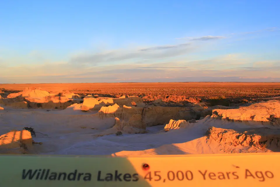
As water levels fluctuated and finally vanished, dominant westerly winds swept across the exposed lake floors and piled quartz sand and pelleted clay onto the eastern (leeward) margins to build crescent-shaped dune ridges known as lunettes. Rising 40 metres above the flat saltbush and mallee eucalypt plains, these stabilised ridges include the world's largest clay lunette at Chibnalwood and the eroded Walls of China along the eastern shore of Lake Mungo. Subsequent rain and wind gullying cut miniature canyons into the Lake Mungo lunette, exposing three distinct sedimentary layers that chronicle the environmental history of the last 100,000 years.
At the base of the sequence lie orange-red sediments deposited more than 50,000 years ago. The red sands are ancient. Above them rests a middle horizon of clean quartz sand, greyish clay, and soil laid down from 50,000 down to 19,000 years ago when the basins held deep, fresh water teeming with fish and shellfish. Capping the lunettes is a top layer of wind-blown clay particles heaped onto the dunes during the final drying phases before 18,500 years ago. In addition to preserving giant marsupial fossils, this undisturbed stratigraphy records a major late-Pleistocene shift in the Earth's magnetic field known as the Mungo Geomagnetic Excursion, providing a critical benchmark for palaeomagnetic and palaeoclimatic science across southeastern Australia.
Forty-Two Millennia of Aboriginal Life and Western Lands Pastoralism
For the traditionally affiliated Paakantyi, Muthi Muthi, and Ngiyampaa Aboriginal peoples, the Willandra lakeshores have been a living cultural homeland for 40,000 to 60,000 years, with stratified occupation deposits firmly establishing that Homo sapiens sapiens had dispersed across Australia by 42,000 years before present. Along the freshwater beaches, Pleistocene inhabitants transported ochre pigments before 42,000 years BP, left behind stone tools that defined the typology of early Australian lithics, and accumulated vast shell middens and baked-earth hearths. These lunette sediments preserved the world's oldest known ritual cremation alongside early ochre-strewn human burials. Subsequent erosion also exposed fossilised human trackways pressed into damp clay from 19,000 to 23,000 years ago, capturing the exact stride and pace of Pleistocene men, women, and children walking across the lake margin.
European entry into the lower Darling and Murrumbidgee river corridors began when Captain Charles Sturt reached the upper Darling River in 1829 (naming it after Governor Ralph Darling) and returned in 1844, while Surveyor George Boyle White explored the Peel River junction to Fort Bourke in 1833. Major Thomas Mitchell, Surveyor-General of New South Wales, marched south to Laidley's Ponds two years later and followed the Murrumbidgee to the junction of the Darling and the Murray in 1836. Stockmen soon drove sheep and cattle along the Murrumbidgee and Murray route toward South Australia: George Hobler claimed the Paika run on the Lachlan in 1845, the Darling Pastoral District was proclaimed on 4 December 1847, and the Burke and Wills expedition later crossed the inland back blocks. River navigation pioneered by Francis Cadell and William Randell in 1853 doubled the value of riverfront properties within six months, prompting pastoral leases across the dry lake beds, including George Lee at Turlee on 28 February 1850, George Mory at Boomiaricool in December 1853, and James Scott at Arumpo in October 1859.
Operating sheep stations on the waterless back blocks proved a harsh financial gamble that reshaped the fragile lunette and saltbush vegetation. At Gol Gol Station (taken over by J. H. Patterson in 1875, sold to Everitt and White in 1882, and repossessed by Patterson in 1886), workers including Chinese well-sinker Ah Tin sank eighty-three trial shafts at a cost of 1,260 pounds between March 1875 and September 1881, while 303 Chinese labourers camped at Narrandera by 1883 searching for station work. Aboriginal shepherds sustained the runs during the 1860s manpower shortage until wire fencing and paddocking in the mid-1870s made traditional shepherding redundant. Severe overstocking of edible shrubs, invasive rabbits (targeted by the Rabbit Nuisance Act of 1883 with scalp bonuses until myxomatosis arrived in the 1950s), and the relentless drought of 1895 to 1903 alongside the 1890s recession ruined many lessees and prompted the Royal Commissions of 1900 and 1901. On 1 January 1901, new legislation placed the Western Division under the Western Lands Board and extended leases by forty-two years to provide more secure tenure. After World War One, smaller owner-occupier families such as Ewan and Nagus Cameron at Mungo Station acquired the homestead and shearing quarters, introduced ten mechanical shearing machines to the Mungo and Gol Gol sheds, connected Arumpo, Pan Ban, and Mulurulu by telephone in 1924, and gathered for Albert Barnes's Mungo Gymkhana on the southern rim at Joulni Station before motor vehicles in the 1930s linked the stations to hospital care in Mildura. The site was inscribed by UNESCO in 1981, added on 2 April 1999 to the State Heritage Register of New South Wales, and placed on 21 May 2007 onto the Australian National Heritage List under the 2003 Environment and Heritage Legislation Amendment Act.
Exploring Mungo National Park and the Lunette Gullies
Today the dry lake beds and spinifex sand ridges shelter 20 mammal species (led by diverse bat populations), 40 species of reptiles and amphibians, and 137 recorded bird species including cockatoos, parrots, and finches across a vast outback horizon where Aboriginal traditional owners and pastoral landholder families maintain deep ties to the land. In this remote pastoral country, historic isolation fostered strong neighbourly support and self-sufficiency across the stations.
- Entry and Route at Mungo Station: Approach Lake Mungo via the unsealed roads extending 100 kilometres northeast from Mildura and begin your visit at the historic Mungo shearing shed, erected during the pastoral era near the western edge of the dry lake floor. Walk through the station precinct to see how post-1901 Western Lands leases overlapped with the ancient meeting grounds of the Muthi Muthi, Ngiyampaa, and Paakantyi peoples.
- Tickets, Interiors and Viewpoints at the Walls of China: Drive across the flat, saltbush-covered bed of ancient Lake Mungo to the eastern margin, where the 40-metre crescentic dune ridge of the Walls of China rises against the prevailing westerly winds. Join an accredited Aboriginal tour to walk among the eroded miniature canyons, inspecting the orange-red basal sands over 50,000 years old, the middle freshwater quartz layer, and the upper wind-blown clay crust that yielded 42,000-year-old hearths and shell middens.
- Timing and Onward Connections from Mildura: Because summer heat across the Far West semi-arid zone is extreme and the unsealed tracks out of Mildura and Hillston can close immediately after rain, schedule your crossing for the cooler months between April and October and carry ample water and fuel. Compare Willandra's Pleistocene human record and dry lakebed geomorphology with Australia's northern tropical cultural landscapes and global desert basins in our UNESCO World Heritage Atlas as you plan your wider outback journey across New South Wales.
