Garbage Free Concert at Mexico City Zócalo: Plaza Access, Metro Routes and Centro Histórico Tips
How the free open-air Garbage show at Plaza de la Constitución works on Saturday 14 November 2026, including security filters, open Metro stations, delay screens and Centro Histórico rooftops.
Overview
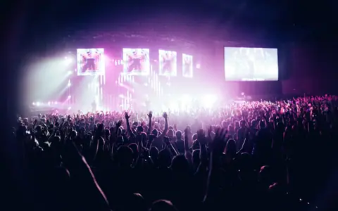
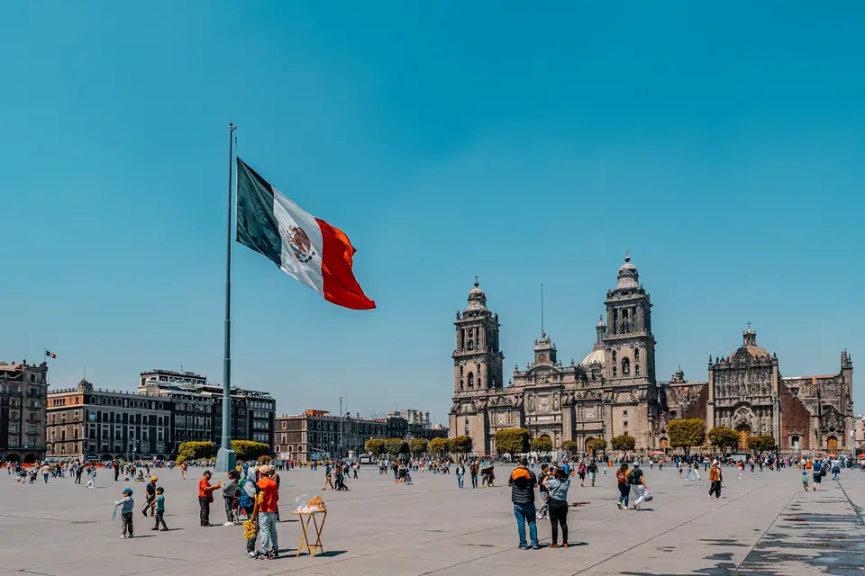
Few live music settings anywhere in the Americas match the scale of Plaza de la Constitución, universally known as the Zócalo, in the heart of Mexico City. On Saturday 14 November 2026, Scottish-American alternative rock band Garbage, fronted by Shirley Manson alongside Duke Erikson, Steve Marker, and Butch Vig, play a free open-air concert at 8:00 p.m. in the historic square. Organised in partnership with the Mexico City Secretariat of Culture (Secretaría de Cultura de la Ciudad de México), the performance turns one of the largest public plazas on earth into an admission-free rock arena framed by the twin bell towers of the Metropolitan Cathedral, the long baroque facade of the National Palace, and the arcades of the Old City Hall.
How a Free Zócalo Mega-Concert Works
Unlike ticketed stadium dates in Los Angeles, Houston, or Miami, a civic concert on the Zócalo requires no advance registration, barcode, or wristband. The entire flat stone expanse of the square opens to the public on a first-come, first-served basis. For major international headliners, capacity across the central square and its adjacent approach avenues regularly exceeds one hundred thousand spectators.
To keep crowd density safe across the stone paving, city civil protection authorities divide the square into fenced standing sectors separated by emergency corridors running from east to west and north to south. Once the front sectors closest to the stage directly in front of the Metropolitan Cathedral reach capacity, security stewards close those inner gates and direct newly arriving fans into the mid-plaza sectors or the wide southern approach along Avenida 20 de Noviembre, where secondary delay screens and high-output speaker towers relay the live mix without distortion.
Sightlines, Delay Screens and Balcony Terraces
Because the Zócalo is completely flat, your experience depends heavily on where you choose to stand:
- Front Barrier and Central Plaza: Die-hard fans aiming for the front sectors gather at the perimeter checkpoints hours before sunset. Once inside a front corral, leaving for toilets or refreshments during the evening can mean forfeiting your spot if that sector has already reached full capacity.
- 20 de Noviembre and Cathedral Flanks: If you prefer breathing room and an easier exit after the encore, stand near the secondary delay towers along Avenida 20 de Noviembre or beside the western arcade portals (Portal de Mercaderes), where families and late arrivals enjoy clear screen views and quick access to side streets.
- Perimeter Rooftop Terraces: Several historic hotels and restaurants lining Monte de Piedad, 16 de Septiembre, and 5 de Mayo feature elevated dining terraces overlooking the square. These tables book out immediately after a Zócalo concert announcement, so reserve directly with the venue well ahead of the weekend.
Tickets & Getting There
No Tickets Required: Security Filters and Entry Streets
Admission to Garbage at the Zócalo is completely free, and anyone attempting to sell passes or VIP wristbands online or in the surrounding streets should be ignored. Instead of ticket turnstiles, city authorities set up walk-through security checkpoints (filtros de acceso) several blocks back from the square along the main arteries feeding into Centro Histórico, primarily Calle Francisco I. Madero, Calle 5 de Mayo, Avenida 20 de Noviembre, and Avenida José María Pino Suárez.
Metro Stations and Getting to Centro Histórico
On every major Zócalo concert day, Zócalo/Tenochtitlan Metro Station on Line 2 (directly underneath the plaza) is closed throughout the afternoon and evening for pedestrian safety. Load a Tarjeta de Movilidad Integrada smartcard and use one of the surrounding stations within a ten-minute walk:
- Bellas Artes (Lines 2 and 8) and San Juan de Letrán (Line 8): Exit beside Alameda Central and walk east along pedestrianised Calle Francisco I. Madero or Calle 5 de Mayo straight into the western entry filters.
- Allende (Line 2): Located two blocks north-west of the Cathedral along Calle Tacuba, though it can close temporarily if northern queues build up.
- Pino Suárez (Lines 1 and 2): Ideal when arriving from southern neighbourhoods; walk north up Avenida José María Pino Suárez past the Supreme Court into the southern plaza checkpoints.
- Metrobús Line 4 and Trolebús Line 1: Surface buses along Eje Central Lázaro Cárdenas drop passengers near the Bellas Artes approach corridor. Travellers connecting from our USA routes should note that cars and taxis cannot enter the inner perimeter on show afternoons.
Tips
What Passes the Plaza Checkpoints and Evening Altitude Tips
Police and civil protection officers inspect bags at the street filters before you reach the plaza corners. Keep your setup minimal so you move through the pedestrian lanes quickly:
- Prohibited Items at the Filters: Large backpacks, glass bottles, cans, alcoholic beverages, sharp objects, aerosols, fireworks, laser pointers, drones, long umbrellas with metal points, and heavy metal-buckled belts are confiscated at the perimeter gates. Bring a small cross-body pouch or clear bag instead.
- Dress for Mexico City's November Altitude: Sitting more than two thousand two hundred metres above sea level, Mexico City enjoys mild, sunny afternoons in mid-November, but temperatures drop briskly as soon as the sun dips behind the historic facades. Wear breathable layers and pack a foldable rain poncho rather than a rigid umbrella.
- Hydration, Cash and Mobile Signal: Drink plenty of water during the afternoon in sealed soft plastic bottles (note that security officers sometimes ask you to remove the bottle cap at the checkpoint), carry small Mexican peso notes for street stalls outside the perimeter, and agree on a fixed physical meeting point with your group near Palacio de Bellas Artes in case mobile data networks slow down when a hundred thousand phones connect at once.
The route on the map
- 1Plaza de la Constitución (Zócalo Main Stage) · Mexico City's monumental central square framed by the Metropolitan Cathedral and the National Palace, hosting the free open-air stage.
- 2Allende & Bellas Artes Metro Stations (Line 2 Approach) · Primary Metro stations north-west of the square when Zócalo/Tenochtitlan station closes for concert crowd control.
- 3Calle Francisco I. Madero Pedestrian Corridor · Historic pedestrian boulevard connecting Alameda Central and Palacio de Bellas Artes with the western entry checkpoints.
- 4Pino Suárez Metro Interchange (Lines 1 & 2) · Southern interchange station providing direct foot access up Avenida José María Pino Suárez toward the southern plaza filters.
Reviews
Log in to write a review.
No reviews yet.