


























Quick Field Data
- UNESCO Inscription: 1991 (Natural heritage site in the Arlit Department of northern Niger; placed on the List of World Heritage in Danger in 1992)
- Scale & Footprint: 7,736,000 hectares (77,360 square kilometres), constituting the largest protected nature reserve in Africa across the eastern Aïr massif and western Ténéré desert
- Access & Ticketing: Administered by the Ministry of Environment and the national conservation authorities; check the official site for current regional security advisories, desert expedition permits, and strict sanctuary entry rules
- Arrival Logistics: Arlit lies south of the reserve as the historic caravan and administrative centre, with desert tracks leading northeast via the mountain oasis settlements where the reserve headquarters was established
Palaeozoic Ring-Dykes of the Aïr and the Shifting Erg of the Ténéré
Stretching across 7,736,000 hectares in the central Sahara of northern Niger, the Air and Ténéré Natural Reserves encompass the largest protected natural landscape on the African continent. Within Niger, the UNESCO World Heritage Atlas in 1991 and placed on the List of World Heritage in Danger in 1992 following civil unrest, the reserve spans two contrasting geological and ecological realms within the Arlit Department: the rugged crystalline and volcanic mountains of the Aïr massif in the west, taking up roughly two-fifths of the territory, and the vast hyper-arid sand sea of the Ténéré desert in the east, covering the remaining three-fifths. Positioned between latitudes 18 and 20 degrees north, this transition links Sahelian mountain valleys with the extreme desert plains of the Sahara.
The Aïr mountains rise as a dramatic rocky island from the surrounding plains, composed of Precambrian metamorphic basement rocks pierced by a north-south chain of Palaeozoic granitic ring-dyke massifs and Cenozoic volcanic cones, calderas, and lava flows. Nine steep circular mountain complexes climb steeply above incised wadis and stony plateaux, culminating in the highest peaks of the Montagnes Bleus and Aïr massif, the highest peak in Niger at 2,000 metres, alongside neighboring massifs such as the surrounding granite ring-dyke massifs of the Aïr Mountains. Deeply carved gorges, hot springs, and seasonal boulder-strewn streambeds called koris drain the mountain slopes, trapping scarce summer monsoon rains in underground alluvial aquifers and shaded rock pools known as gueltas.
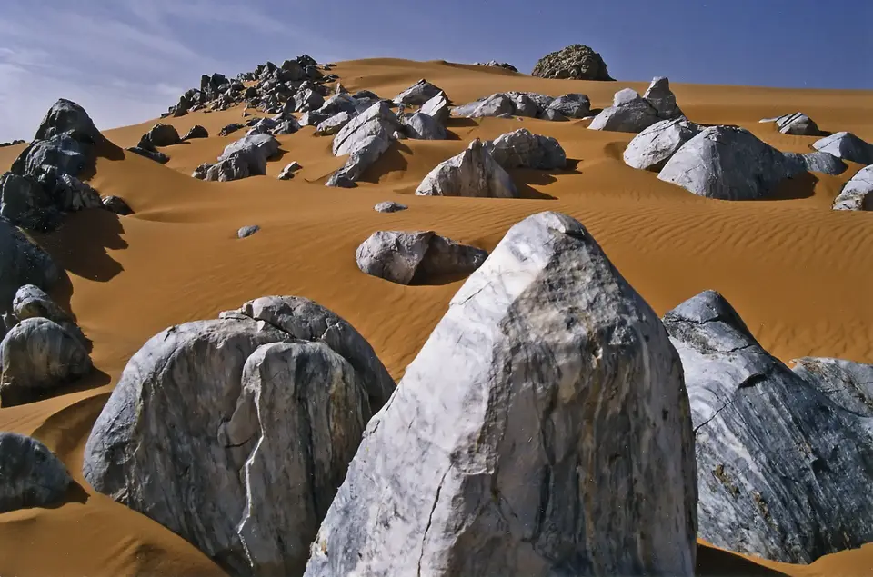
Along the eastern escarpment of the Aïr, the mountain walls drop abruptly onto the flat gravel plains, or reg, and shifting sand dunes, or erg, of the Ténéré. Swept by dry northeastern prevailing desert winds throughout the winter months, the Ténéré forms a continuous sea of mobile linear dunes and towering star dunes that reach heights of great heights around sectors such as the eastern escarpment. Temperatures fluctuate wildly across the seasons, dropping to freezing temperatures on winter nights and climbing to 50 degrees in the shade during May and June, while annual rainfall ranges from scarcely 20 millimetres out in the open Ténéré to between 50 and 165 millimetres on the upper plateaux of the Aïr, with isolated years recording complete drought.
Relict Mediterranean Flora and Saharo-Sahelian Desert Fauna
Because the Aïr massif captures moisture and moderates temperatures at higher elevations while blocking the advance of mobile dunes on its windward slopes, the reserve preserves an extraordinary biogeographical pocket where Sahelian, Sudanese, Saharan, and relict Mediterranean plant species coexist across numerous recorded vascular plants. Along the sandy beds of the major wadis, subterranean water sustains dense gallery woodlands of drought-resistant thorn trees, wild palms, and perennial desert grasses along the seasonal watercourses. Higher up inside sheltered mountain ravines at high elevations, isolated populations of wild olive related to relict Saharo-Mediterranean olive trees survive as living witnesses to wetter Holocene climatic phases, while ephemeral desert pastures known as achab sprout briefly across the sandy borders of the Ténéré whenever sporadic summer showers fall.
This mosaic of mountain refuges and ephemeral pastures supports around around 40 mammal species alongside 165 bird species and 18 reptile species adapted to extreme aridity. Within the reserve's core lies the 12,800 square kilometre Addax Sanctuary, established to protect the last wild populations of the critically endangered addax, the desert addax, a spiral-horned desert antelope capable of surviving almost indefinitely without free-standing drinking water by extracting moisture from desert plants such as ephemeral desert herbs and perennial grasses. Alongside the addax, the reserve provides essential habitat for the endangered dama gazelle, the Dama gazelle, the slender-horned gazelle, the Dorcas gazelle, and the Barbary sheep, which scales the precipitous granite cliffs of the ring-dykes.
Small isolated troops of olive baboons, and patas monkeys, survive inside the mountain gorges, alongside Cape hyrax, fennec foxes, Rüppells foxes, caracals, and striped hyenas, while Saharan cheetahs, desert cheetahs, have historically roamed the remote wadi systems. Roughly numerous resident bird species breed in the reserve, supplemented by dozens of seasonal migrants that rely on the vegetated koris as stepping stones across the Sahara. Resident species included the North African ostrich, and the Nubian bustard, while sandgrouses, wheatears, larks, and desert raptors frequent the cliffs and oasis gardens. Because the Aïr massif rises as a high Sahelian-type enclave surrounded on all sides by the hyper-arid Sahara, its sheltered valleys act as an ecological refuge where Sudanese, Saharo-Sahelian, and Saharo-Mediterranean plant and animal communities survive hundreds of kilometres north of their continuous mainland ranges. Conservation initiatives developed in partnership with the IUCN and international conservation bodies have worked alongside the local Tuareg People to reconcile traditional pastoral livelihoods and irrigated oasis gardening with the protection of desert antelopes, Barbary sheep, Rüppells foxes, and Nubian bustards across the reserve.
Tuareg Oasis Culture, Caravan Heritage, and Field Expeditions
Human presence in the Aïr and Ténéré spans millennia of climatic change. Archaeological sites scattered from the eastern desert valleys to the mountain valleys preserve Neolithic stone tools, pottery from past pastoralist cultures when lakes covered parts of the Ténéré, and thousands of prehistoric rock engravings carved into granite boulders depicting giraffes, elephants, ostriches, cattle, and ancient Saharan warriors with chariots and horses. Today, the Aïr massif remains the heartland of the Tuareg People, whose semi-nomadic and settled communities inhabit oasis villages such as the mountain oasis settlementsacross the Aïr valleys. In irrigated valley gardens watered by shallow wells drawn by camels and donkeys, cultivators grow date palms, wheat, maize, garlic, onions, pomegranates, and citrus fruits, while salt caravans operated by Tuareg caravaners have crossed the Ténéré dunes between the Aïr and the salt pits of the eastern oasis basins.
For travellers consulting the UNESCO World Heritage Atlas, visiting the Air and Ténéré Natural Reserves demands thorough preparation, government clearances, and experienced local Tuareg guides driving four-wheel-drive vehicles or leading camel caravans from Arlit and the mountain oasis settlements. Six-tenths of the reserve operates as an IUCN Category IV managed nature reserve where traditional agro-pastoralism continues, while one-sixth forms the strict Category Ia Addax Sanctuary where motorised tourist access is restricted.
- the mountain oasis settlements valley and the northern ring-dykes: functioning as the northern gateway and conservation base of the reserve, the oasis town of the mountain oasis settlements sits along the broad western mountain valley where doum palms and irrigated gardens border the granite ramparts of the northern Aïr Mountains. Tracks from the mountain oasis settlements follow dry sandy koris toward the canyon walls of the granite gorges and the prehistoric rock art panels of the western foothills and northern Aïr.
- Central mountain oases, rock pools, and the highest peaks of the Aïr Mountains: South of the mountain oasis settlements, rugged mountain pistes wind through volcanic plateaux to the palm-shaded gorge of the central Aïr gorges, celebrated for its seasonal waterfall, perennial guelta pools, and citrus orchards. From the surrounding highland valleys, trekking routes with pack camels ascend toward the 2,000-metre summit plateau of the highest peaks of the Montagnes Bleus and Aïr massif and the medieval stone ruins of early caravan settlements, once the thriving caravan capital of the Aïr.
- the eastern mountain margin dunes and the western edge of the Ténéré: Where the eastern granite cliffs of the eastern Aïr escarpment plunge directly into the sand sea, wind-sculpted golden dunes. Desert winds sculpt every ridge. Here, mobile dunes climb up the dark rock faces at the eastern mountain margin. Expeditions skirting the outer boundary of the strict Addax Sanctuary witness the stark transition between shaded acacia wadis and the treeless gravel regs and towering ergs of the open Ténéré desert, where wind-blown sand plains stretch unbroken across the horizon and preserve a complete sequence of Saharan and Sahelian desert landforms.
