Quick Field Data
- UNESCO Inscription: Cultural World Heritage Site (Ref. 278), inscribed in 2019 under Criterion (iii).
- Scale & Footprint: 1,054.3 hectares in Babil Governorate near modern Hillah, spanning roughly 450 hectares inside the inner city walls, surrounding rural villages, and 85 percent unexcavated archaeological strata.
- Access & Ticketing: Entry is ticketed at the archaeological site gate and overseen by Iraq's State Board of Antiquities and Heritage with Antiquity and Heritage Police stationed adjacent to the complex; 1980s modern reconstructions sit as excluded internal buffer zones.
- Arrival Logistics: Baghdad International Airport (BGW) sits 82 km north, with Hillah 85 km south of Baghdad; Mardin lies 628 km to the northwest across upper Mesopotamia.
Euphrates Geography, Akkadian Origins, and Hammurabi's Capital
Stretching across the lower Euphrates alluvial plain in modern Hillah, Iraq, 85 km south of Baghdad, Babylon is roughly bisected by the Shatt Al-Hillah branch of the Euphrates. Its meandering channel has shifted slightly since antiquity while pushing up the modern water table beneath lower strata. Classical writers later ranked its walls and purported Hanging Gardens among the seven famed achievements of antiquity, linking them to the 600 BCE to 1 CE city. However, historians note that no extant Babylonian cuneiform text mentions those gardens, and the settlement itself began modestly. The earliest firm mention appears in a year-name of Akkadian ruler Shar-Kali-Sharri (reigned 2217 to 2193 BCE), recording temples built for Annunitum and Ilaba when Babylon was a small town in the Akkadian Empire. An unprovenanced Early Dynastic II limestone inscription from around 2700 BCE hints at even older roots.
Even the city's name reveals layered Mesopotamian philology. Greek writers transcribed native Akkadian Babilim ('gate of the gods') as Babylon, matching the Sumerian cuneiform logogram Kan digirak. Writing in the 1870s, Archibald Sayce suggested Semitic speakers translated an older Sumerian name. In 1955, scholar I. J. Gelb demonstrated that the original name was likely a pre-Sumerian toponym, Babilla. Semitic folk etymology reinterpreted it under Akkadian rule, and scribes translated it back into Sumerian under the Third Dynasty of Ur. Phonetic variants such as Babalu and Babbar persisted into Kassite times, while later cuneiform scribes used spellings including TIN.TIR.KI and E.KI. Only in the Hebrew Bible (Genesis 11:9) did Babel become linked by wordplay to 'confusion', unrelated to the modern English verb to babble. Modern scholarship pieces together Babylon across five uneven records: local excavations, Mesopotamian cuneiform tablets, biblical texts, Herodotus, and secondary summaries of Ctesias and Berossus.
After Akkadian collapse, Gutian rule, and control by the Third Dynasty of Ur, Babylon emerged in the early second millennium BCE as an independent city-state. Under the Amorite king Hammurabi in the 18th century BCE, the Old Babylonian Empire expanded across southern Mesopotamia, elevating Babylon above ancient Nippur as the region's supreme political and sacred centre (along nearby cities Kish, Borsippa, Dilbat, and Kutha). Estimates suggest Babylon ranked as the world's largest city from around 1770 to 1670 BCE, before waning under Hammurabi's son Samsu-iluna into long periods of Kassite, Elamite, and Assyrian domination.
Nebuchadnezzar's Neo-Babylonian Zenith and Glazed Brick Art
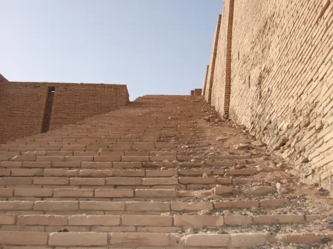
Following Assyrian destruction and rebuilding, Babylon rose to architectural dominance as capital of the Neo-Babylonian Empire from 626 to 539 BCE, especially during the 43-year reign of Nebuchadnezzar II (605 to 562 BCE). Reaching perhaps over 200,000 residents across roughly 900 hectares, it became the world's largest city again between around 612 and 320 BCE. Builders shifted decisively from sun-dried mud-brick to monumental baked bricks mortared with sticky natural bitumen. Seven major archaeological mounds preserve that urban geography today. Central Kasr rises 19 metres above the plain over Nebuchadnezzar's Southern and Northern palaces, while southern Amran Ibn Ali (22 metres high) buries Esagila, Marduk's primary temple with shrines to Ea and Nabu. Nearby Sahn holds the ziggurat Etemenanki, the prototype for traditions of the Tower of Babel, beside residential Merkes at 13 metres high. Reddish western Homera holds Hellenistic layers and brick rubble left when Alexander the Great demolished Etemenanki in 331 BCE, alongside northern Babil (25 metres high, site of Nebuchadnezzar's summer palace) and Ishin-Aswad.
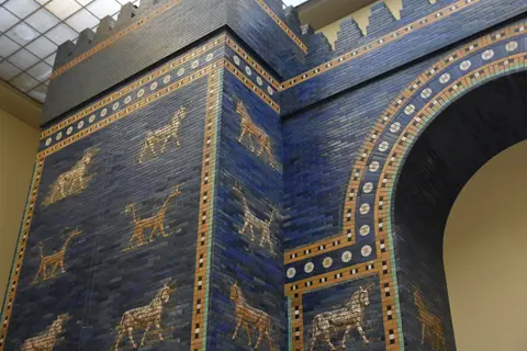
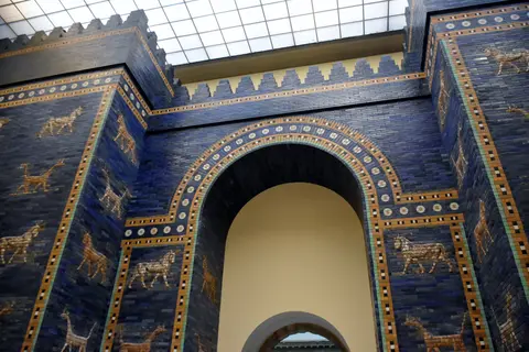
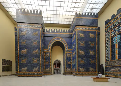
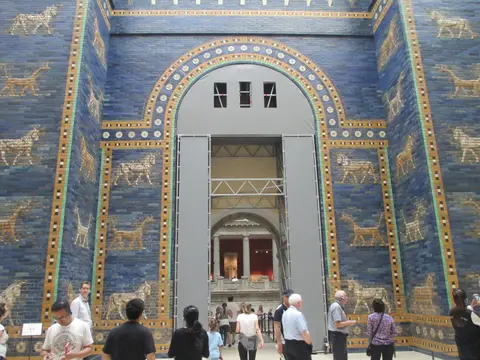
Running north out of the royal core stood Babylon's eighth inner gateway through the double walls Imgur-Bel and Nimitti-Bel. Built around 569 BCE by Nebuchadnezzar II, the Ishtar Gate formed one monumental element of a metropolis decorated with over 15 million baked bricks. This double gate paired a smaller front portal with a massive rear chamber 15 metres high above foundations sunk 14 metres to the water table. Lengthwise cedar roof beams topped three main passages fitted with bronze-overlaid cedar doors, comprising a central fourfold-door portal flanked by twin double-door entrances. A 60-line Akkadian cuneiform dedication measuring 15 metres tall by 10 metres wide explained Nebuchadnezzar's motive. Rising street fill along Babylon's thoroughfares had left the older gates of Imgur-Ellil and Nemetti-Ellil dangerously low, forcing him to demolish them. He sank deep foundations of bitumen and fired brick to the water table and clad the new gate in vivid blue glazed tiles evoking lapis lazuli, alongside Marduk's asphalt-and-brick festival house, Esiskursiskur.
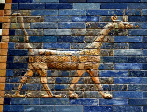
Craftsmen pressed clay into reusable wooden moulds, sun-dried and bisque-fired the bricks, and coated them in frit glazes mixed from plant ash, sandstone conglomerates, pebbles, and cobalt minerals. Across the gate towers, alternating relief rows showed Marduk's sacred mushhushshu dragons and Adad's aurochs bulls. Workers sealed 1 to 6 mm seams with black bitumen and kept joints carefully clear of the animals' eyes. Beyond the gate, the stone-and-bitumen Processional Way ran over 800 metres north at widths up to 20 metres (66 feet), hosting the annual twelve-day New Year festival in late March. Crenelated brick walls flanked the avenue with 60 sculpted lions on each side, 120 in all. Each lion used 46 moulded bricks across 11 horizontal rows, with left paws advancing on the east wall and right paws forward on the west.
After Babylon fell in 539 BCE, the city remained a major regional capital under Achaemenid, Seleucid, Parthian, Roman, Sassanid, and early Islamic rulers, leaving Hellenistic layers including a theatre, before shrinking into what 11th-century CE accounts called the small village of Babel. Throughout those centuries, Babylon radiated mathematics, astronomy, and cuneiform literary culture across the Near East and seeded global philosophical and religious imagery across Judaism, Christianity, and Islam.
Archaeological Expeditions, 1980s Reconstructions, and Urgent Risks
Modern rediscovery unfolded unevenly across two centuries of excavation and looting. British East India Company resident Claudius Rich surveyed the mounds in 1811 and 1817, publishing the first systematic topographical maps in 1815. Later surveyors included Robert Mignan (1827 to 1829), William Loftus (1849), Austen Henry Layard (1850), and Henry Rawlinson and George Smith (1854). French excavators Fulgence Fresnel, Julius Oppert, and Felix Thomas dug heavily from 1852 to 1854. However, Tigris river pirates sank over 200 crates of antiquities in the May 1855 Qurnah Disaster. Barely 80 salvaged crates reached France, despite Japanese recovery attempts in 1971. Industrial-scale digging by Hormuzd Rassam for the British Museum between 1879 and 1882 curbed looting but damaged fragile mud-brick contexts.
Scientific archaeology began when Robert Koldewey and the German Oriental Society worked daily from 1899 until fleeing advancing British troops in 1917. Battling local brick-mining for projects such as the Hindiya dam, Koldewey's team and architect Walter Andrae traced the Processional Way and temples. They recovered 967 Old Babylonian tablets, 564 Middle Babylonian literary and lexical texts, and the 14-metre subterranean foundations of the Ishtar Gate. After 1918, conservators reconstructed that gate at 14 metres high by 30 metres wide inside Berlin's Pergamon Museum. Subsequent German Archaeological Institute work by Heinrich J. Lenzen (1956, focusing on the Hellenistic theatre) and Hansjorg Schmid (1962, studying Etemenanki) preceded 1974 and 1977 topographical surveys.
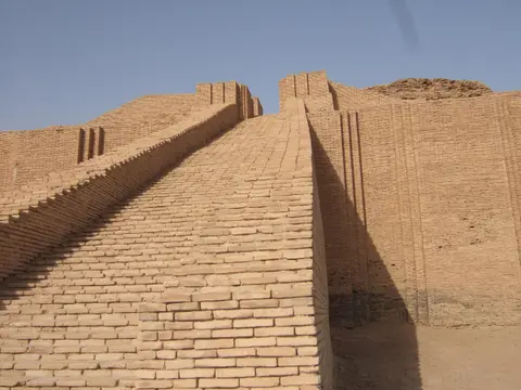
Yet modern interventions created acute authenticity challenges. During the 1980s 'Revival of Babylon Project', builders erected full-height brick palaces and a replica Ishtar Gate directly atop excavated ancient foundations. Built largely on conjecture rather than firm archaeological evidence, these modern materials obscure original Neo-Babylonian forms. When inscribing Babylon in 2019, UNESCO therefore placed those 20th-century structures into excluded internal above-ground buffer zones. Management operates under Iraq's Antiquities and Heritage Law No. 55 of 2002 and a 2018 Management Plan overseen by the State Board of Antiquities and Heritage and Babil's Directorate of Antiquities and Heritage. Even so, Babylon faces severe threats from rainfall erosion, rising saline groundwater, local housing encroachment, waste dumping and burning, and small-scale industrial pollution. Protecting the unexcavated 85 percent of the city remains Iraq's paramount archaeological priority.
Archaeological Mounds, Modern Reconstructions, and Access Rules
Walking Babylon requires separating intact ancient brickwork and subterranean foundations from the towering 1980s reconstructions concentrated around the northern entrance and Southern Citadel.
| Complex Zone | Key Highlights | Access & Ticket Rule |
|---|---|---|
| Processional Way and Ishtar Gate Sector | Deep ancient brick foundations beneath the smaller replica gate, bitumen paving, and lower relief rows | Included in main site ticket; 1980s replica walls occupy excluded buffer zones above genuine strata |
| Kasr and Southern Citadel Mounds | Nebuchadnezzar's palatial courts, massive modern brick reconstructions, and deep Neo-Babylonian fortification foundations | Open along fenced visitor walkways; climbing unstable mud-brick mounds or unexcavated slopes strictly prohibited |
| Sahn (Etemenanki) and Amran Ibn Ali | Sunken square footprint of the demolished Marduk ziggurat and 22-metre mound concealing Esagila temple | Visible from designated ground viewpoints; high groundwater restricts access to deep flooded trenches |
| Homera and Hellenistic Theatre | Reddish western rubble mounds from Alexander's 331 BCE demolition and restored classical amphitheatre seating | Accessible along eastern and western site roads; observe protective barriers around fragile mud-brick tiers |
Confirm current site access, security escort requirements, and small site-museum entry protocols through local Iraqi antiquities authorities or licensed guides before travelling south from Baghdad.
Bitumen Seams, Brick-Mould Seams, and Excavated Foundations at Babylon
Looking closely below the modern 1980s brickwork reveals three diagnostic construction traits that enabled Neo-Babylonian builders to raise massive structures across an alluvial floodplain:
- Bitumen-sealed mortar joints and Processional Way beds: Along surviving ancient brick courses and exposed roadbeds, trace the thin 1 to 6 mm black seams of natural Mesopotamian bitumen used to waterproof foundation bricks against Euphrates seepage and anchor stone paving slabs.
- Non-intersecting animal relief moulds on Ishtar Gate bricks: Remember that each moulded bull, dragon, or 46-brick lion was laid out so horizontal brick joints never sliced across an animal's eye, preserving crisp visual legibility across glazed relief friezes.
- Conjectural 1980s brickwork atop submerged ancient walls: At the Southern Palace and gate foundations, contrast uniform pale late-20th-century stamped restoration courses above ground against older weathered baked bricks sunk deep toward the rising water table below.
Cool-Season Timing and Pairing Babylon with Mardin
Because southern Iraq experiences brutal summer desert heat and heavy seasonal dust, visiting Babylon between late autumn and early spring keeps long open-air walks across the unshaded Kasr and Homera mounds comfortable while reducing mud hazards after winter rains. Early daylight hours offer clear directional sunlight across brick reliefs and quiet paths before weekend Iraqi tour groups arrive. Travellers tracing ancient Mesopotamian waterways and Upper Tigris-Euphrates stone architecture northward across borders can link Babylon with Mardin, 628 km to the northwest, or explore further Near Eastern heritage listings inside the UNESCO World Heritage Atlas.