


























Quick Field Data
- UNESCO Inscription: 1982 (Cultural Criteria iii, iv)
- Scale & Footprint: 890-hectare (2,200-acre) state historic park preserving roughly 80 earthen mounds from an original urban zone of 16 square kilometres
- Access & Ticketing: Administered by the Illinois Historic Preservation Division; check the official site for Interpretive Center scheduling and trail access
- Arrival Logistics: Located in St. Clair County, southwestern Illinois, between East St. Louis and Collinsville, 13 kilometres northeast of St. Louis across the Mississippi River
The Rise of a Pre-Columbian Metropolis on the American Bottom
Stretching across the fertile alluvial floodplain known as the American Bottom in southwestern Illinois, just 13 kilometres northeast of St. Louis and 6 kilometres east of the Mississippi River, Cahokia Mounds State Historic Site preserves the central ceremonial precinct of the largest pre-Columbian urban settlement north of Mexico. Recognised in the UNESCO World Heritage Atlas in 1982 under cultural criteria iii and iv (after earlier designations as a National Historic Landmark on 19 July 1964 and inclusion on the federal historic register on 15 October 1966), the site developed during the Mississippian period between 800 and 1400 CE, reaching its demographic and architectural peak between 1050 and 1150 CE. At that height, the ancient city covered roughly 16 square kilometres (6 square miles or 1,600 hectares), incorporated 120 man-made earthen mounds, and supported a resident population estimated between 10,000 and 20,000 people, with wider estimates ranging from 6,000 up to 40,000 inhabitants, comparable to contemporaneous 12th-century London and Paris. No subsequent city in the United States matched those upper population estimates until Philadelphia surpassed 40,000 residents in the 1780s. The scale of the earthworks remains unmatched in the United States.
Although Late Archaic occupation occurred around 1200 BCE, permanent farming settlement began during the Late Woodland period around 600 CE, with small villages of 50 to 100 people cultivating native crops of the Eastern Agricultural Complex before maize farming became widespread around 900 CE and nucleated communities covered 35 to 70 hectares (86 to 173 acres) by the late 900s. Situated near the meeting point of the Mississippi, Missouri, together with Illinois rivers, Cahokia stood at the hub of a mid-continental waterway trade network linking the Great Lakes to the Gulf Coast, importing Lake Superior copper, Mill Creek chert hoes from southwestern Illinois, shark teeth, plus lightning whelk shells while exporting pottery in the Cahokian style and ritual objects to outposts such as the Silvernale site in Minnesota, Trempleau Bluffs in Wisconsin, and the Carson site in Mississippi. Around 1050 CE, during the rapid urban expansion archaeologists call the "Big Bang", three coordinated urban precincts (Cahokia, East St. Louis, alongside St. Louis) were laid out along a north-south grid anchored by the Grand Plaza and Rattlesnake Causeway as immigrants arrived from the Yankeetown, Coles Creek, and Caddo regions and settled upland farming villages of the Richland Complex, expanding the central 1.8-square-kilometre core from an earlier population of 1,400 to 2,800 inhabitants up to a dense urban concentration of 10,200 to 15,300 residents by 1100 CE.
Monks Mound and the Engineered Layout of the Grand Plaza
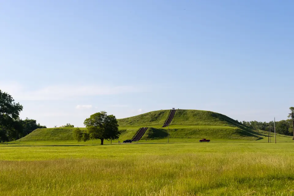
Dominating the heart of the site is Monks Mound (designated Mound 38 by archaeologists), the largest prehistoric earthen structure ever built across the Americas north of Mexico. Named after a community of French Trappist monks who lived on a nearby mound and gardened on its terraces around 1809, this colossal flat-topped pyramid was constructed in 14 stages, rises 30 metres (100 feet) in 4 distinct terraces above the floodplain, measures 290 metres (951 feet) long by 255 metres (836 feet) wide, and covers more than 5.6 hectares (13.8 acres, or roughly 6 hectares) at its base. Across the entire city, workers excavated and carried roughly 1.6 million cubic metres (55 million cubic feet) of earth by hand in woven baskets, with Monks Mound alone requiring an estimated 622,000 to 814,000 cubic metres of clay, silt, plus sand excavated from surrounding borrow pits. Geotechnical studies show that builders alternated layers of sand and clay and inserted internal drainage slopes to stabilise the massive structure against slumping, crowning the fourth terrace with a massive timber building measuring 32 metres long and rising 15 metres high.
Immediately south of Monks Mound stretches the Grand Plaza, covering roughly 19 hectares. Rather than utilizing a natural meadow, Mississippian labourers stripped the undulating ridge-and-swale floodplain topography and backfilled it with up to 1.3 metres of soil within a very short period to create a flat, packed-earth ceremonial court capable of hosting thousands of spectators for public rituals, markets, alongside chunkey, a game played by rolling a polished concave stone disc across the plaza and hurling wooden poles to mark where it would stop. Surrounding the Grand Plaza, the surviving 80 mounds within the 890-hectare (2,200-acre) state historic park, including 51 platform, ridgetop, as well as conical mounds in the core, fall into three distinct architectural types:
- Platform Mounds: Rectangular, flat-topped earthworks such as Monks Mound that functioned as elevated foundations for elite residences, council houses, and temples, physically separating the ruling lineage from the common populace on the plain below.
- Conical Mounds: Circular, dome-shaped earthworks used primarily for elite burials and ceremonial deposits beneath rounded clay caps.
- Ridge-Top Mounds: Elongated, steep-sided linear mounds positioned along the outer edges of the ceremonial precinct and cardinal axes to mark boundaries and house mortuary monuments, including the famous Mound 72 located roughly 850 metres south of Monks Mound.
Mound 72, Woodhenge Solar Calendars, and the Palisade Wall
During the Stirling phase (1100 to 1200 CE), political and religious centralisation reached its zenith across both the floodplain core and upland lunar sanctuaries such as the Emerald Acropolis, whose mounds aligned with the 18.6-year lunar cycle. Excavated beginning in the 1960s by archaeologist Melvin Fowler, Mound 72 revealed the complex ritual stratigraphy of Cahokia's founding elite. Beneath a single ridge-top mound oriented along the solstice axis, archaeologists uncovered the remains of more than 270 individuals buried in distinct ceremonial episodes between 1050 and 1150 CE. At the focal point lay central elite figures placed atop a platform composed of 20,000 shell beads laid out in the shape of a falcon, a primary symbol of the Mississippian warrior and upper-world cosmos. Surrounding burials included caches of unworked mica, rolled sheet copper, polished chunkey stones, 800 finely flaked arrowheads sorted by stone type and regional origin, plus rows of young sacrificial retainers.
Roughly 850 metres west of Monks Mound stands the reconstructed circle of Woodhenge, an astronomical observatory consisting of five sequential red-cedar timber post circles built between 900 and 1100 CE, discovered by archaeologist Warren Wittry in the early 1960s and reconstructed in 1985. Varying from 12 to 72 posts across five phases, including circles of 24, thirty-six, 48, 60, and 72 posts, the reconstructed 48-post circle aligns the spring and autumn equinox sunrises from its central observation post directly with the front face of Monks Mound. Around 1160 to 1175 CE, following the burning of a walled compound in the East St. Louis precinct and rising regional tensions, inhabitants erected a bastioned wooden stockade palisade wall around Cahokia's central ceremonial precinct, rebuilding it several times during the Moorehead phase (1200 to 1300 CE) as the population declined and dispersed toward the Cairo Lowlands and Cumberland Basin before complete abandonment around 1350 CE. When French explorers arrived in the 17th century, the area was inhabited by the historic Cahokia tribe of the Illiniwek confederacy, who gave the site its modern name.
Visiting the Mounds and Navigating the American Bottom
Exploring Cahokia Mounds offers travellers a chance to combine the outdoor walking trails across the Grand Plaza, reconstructed palisade section, and Woodhenge circles with the archaeological collections supported by the Cahokia Mounds Museum Society.
- Entry and Route: The park straddles Collinsville Road just south of Interstate 55 and Interstate 70 (near Interstate 255 exit 24) in St. Clair County, southwestern Illinois, roughly a 15-minute drive across the Mississippi River from downtown St. Louis. Regional transit buses from East St. Louis and Collinsville also pass near the park entrance.
- Tickets and Viewpoints: Entry to the outdoor grounds and the concrete stairway ascending the south face of Monks Mound is administered by the Illinois Historic Preservation Division; check the official site before visiting for updates on Interpretive Center scheduling. From the top terrace of Monks Mound, looking west reveals the skyline of St. Louis framing the distant Mississippi horizon.
- Timing and Onward Connections: Marked walking trails range from short 1.6-kilometre loops around Mounds 59 and 60 in the Grand Plaza to a 10-kilometre nature and culture trail linking Woodhenge and Mound 72. Because the floodplain offers little shade across the plaza and atop Monks Mound, morning or late afternoon walks are far more comfortable during the humid summer months.
