Quick Field Data
- UNESCO Inscription: 2000 (Ref. 971), serial cultural site across Chiloé Province; Criteria (ii) and (iii)
- Scale & Footprint: 16 designated wooden churches covering 13.8977 hectares (13.9 hectares) across the central eastern zone of Chiloé Island and neighbouring Quinchao, Lemuy, Chelín and Caguach islands
- Access & Ticketing: Active parish churches in the Diocese of Ancud; visitor access follows local liturgical schedules and community caretaker hours, with small maintenance donations requested at some doors (check the official site of Fundación Iglesias de Chiloé for restoration updates and opening arrangements)
- Arrival Logistics: Major commercial flights land at El Tepual International Airport (PMC) near Puerto Montt, 124 kilometres from central Chiloé via Route 5 and the two-kilometre Chacao Channel ferry. Mocopulli Airport on Chiloé Island receives four weekly domestic flights, and overland routes connect north to Santiago (1,040 kilometres).
Jesuit Circular Missions and the Chilota Wooden School
Across the Chiloé Archipelago in southern Chile's Los Lagos Region, roughly 70 historic wooden churches mark rural harbours and island headlands, and 16 of them carry World Heritage inscription as the zenith of the Chilota school of timber architecture. Human occupation around this temperate southern coast reaches back far beyond European arrival, with archaeological discoveries at Monte Verde less than 50 kilometres north of the main island dating to between 12,000 and 11,800 BC. Later, seafaring Chonos left abundant shell middens known as chonchales and Chono place names across the archipelago before Huilliche and Cunco groups speaking the dominant indigenous tongue settled the eastern pastures and cultivated long-day native potatoes (Solanum tuberosum tuberosum) suited to southern latitudes.
Spanish forces colonised this isolated island chain in the mid 16th century, when temporary Chilean governor Rodrigo de Quiroga launched a 1567 campaign led by Captain Martín Ruiz de Gamboa that founded Castro on 12 February 1576 as the archipelago's administrative centre. By 1594 Castro held 8,000 inhabitants, largely farmers, even as Dutch pirates repeatedly raided the settlement through the mid 17th century. Following the arrival of Jesuit missionaries in 1608, priests confronted a scattered rural population dispersed across forest clearings, tidal inlets and small eastern islands separated by the Sea of Chiloé. Rather than keeping clergy fixed in a single garrison town, the Jesuits instituted the Circular Mission (Misión Circular).
Under this annual sea-borne circuit, missionary groups sailed from parish to parish throughout the fairer months, staying for a few days at each coastal village where churches were raised jointly with congregations. When the priests departed for the next anchorage, a specially trained layperson remained in charge year-round to maintain the building, guide devotions and guard sacred images. Franciscans continued and expanded the system through the 18th and 19th centuries, long after the Bourbon Reforms of 1767 transferred the archipelago's capital from Castro to Ancud and attached Chiloé directly to the Viceroyalty of Peru. Defending its shores against patriot expeditions until 1826, Chiloé remained Spain's final South American possession, nurturing a cohesive mestizo island culture expressed directly in wood.
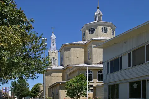
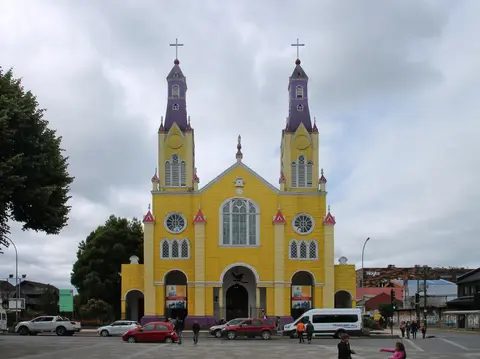
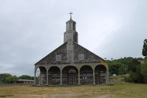
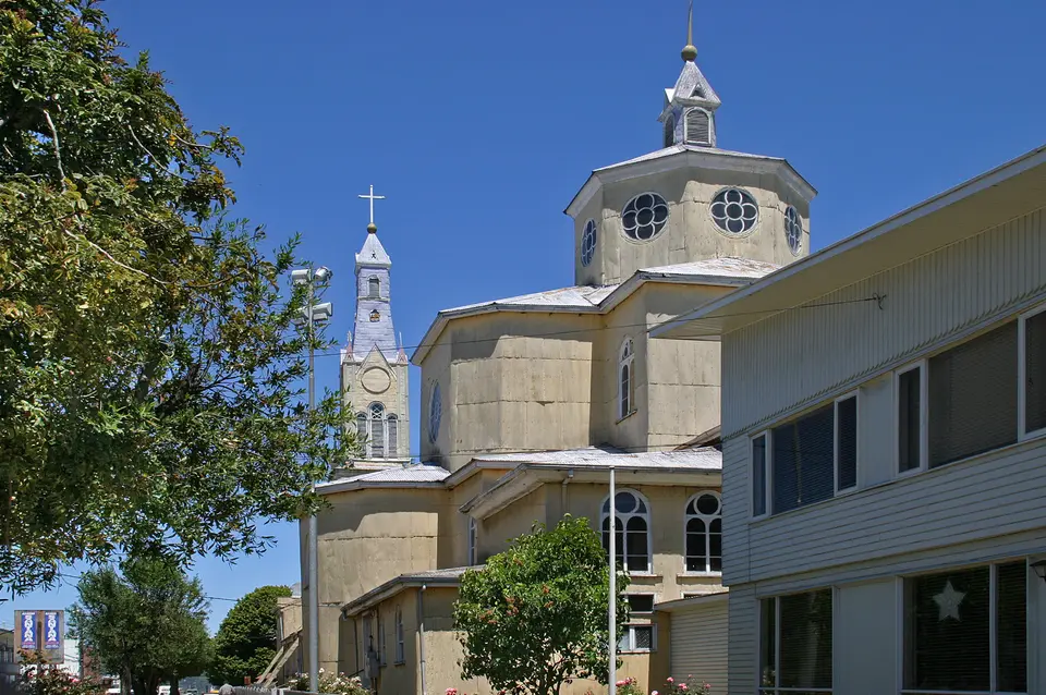
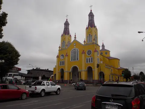
Between the 18th and 19th centuries, the 16 inscribed churches (Achao, Quinchao, Castro, Rilán, Nercón, Aldachildo, Ichuac, Detif, Vilupulli, Chonchi, Tenaún, Colo, San Juan, Dalcahue, Chellín and Caguach) solidified the Chilota ecclesiastical form. Each church adopts a three-bay nave arranged on a Catholic basilican floor plan, framed internally by a tall central barrel-vaulted wooden ceiling and preceded by an open entrance portico beneath a stepped bell tower above the west facade. Traditional painted timber surfaces and devotional sculptures carved on the islands complete an architectural school distinct from mainland Spanish stone and adobe colonies.
Boatbuilding Joinery, Cypress Shingles, and Seaward Siting
Marine carpentry solved the extreme environmental challenge of Chiloé's humid oceanic climate. In Castro, daily mean temperatures hover between 7.3 degrees Celsius in July and 15.9 degrees Celsius in January and February, while annual precipitation averages 1,598.5 millimetres, dropping to 39.7 millimetres in February before climbing to 293.1 millimetres in July. In such persistent dampness and salt air, untreated colonial masonry cracks and iron fasteners rust out quickly. Island farmers, fishermen and boatwrights brought shipyard techniques straight onto land, shaping ceiling vaults like inverted ship hulls and fastening structural frames with carved hardwood pegs and interlocking lap joints capable of flexing during winter gales and strong coastal earthquakes.
Forest cover supplied builders with a rich palette of dense native timber. Chiloé Province spans 9,181 square kilometres, with rectangular Chiloé Island covering 8,394 square kilometres. Its western half remains a rugged expanse of Valdivian temperate rainforest across the north-south Piuchén and Pirulil ranges, rising up to 800 metres over 56 hydrographic basins and roughly 200 glacial lakes including Huillinco-Cucao. Colonising the island some 12,500 years ago, these forests support arrayán (Luma apiculata), coihue (Nothofagus dombeyi), quila (Chusquea quila), avellano (Gevuina avellana), Fitzroya cupressoides and tepú (Tepualia stipularis). Surrounding habitats shelter Darwin's fox, pudú deer and coastal marine mammals such as Commerson's dolphins, blue whales and southern right whales.
Chilote master carpenters prized decay-resistant larch (alerce) and cypress for exterior weatherproofing and framing. Splitting trunks into overlapping tejuela wood shingles, they armoured side walls, gables and octagonal bell-tower spires against driving Pacific rain. In Nercón, a southern parish incorporated into Castro commune in 2007, the Church of Nuestra Señora de Gracia (built from 1886) shows how coihue (Nothofagus dombeyi) provided sturdy structural beams. It stands close to the Nercón River bridge, where small boatyards still build traditional craft from larch wood. Inside each sanctuary, wooden joinery, natural resin finishes and bright devotional colours create warm acoustic chambers tuned for community singing and seasonal prayer.
Location and orientation followed marine logic as closely as joinery did. Carpenters positioned churches on coastal bluffs, gentle rises or wide grassy waterfront esplanades facing the Sea of Chiloé, Gulf of Ancud and Gulf of Corcovado rather than burying them behind narrow urban lanes. Raising towers above coastal inlets protected timber foundations from tidal flooding while turning painted spires into visual landmarks for sailors navigating open waters between Chiloé Island, Quinchao, Lemuy and the Desertores Islands. Even in Castro, where historic plazas replaced grassy foreshores beside Iglesia San Francisco, and where stilt palafito houses line the Gamboa district along Fiordo de Castro, the church square preserves the historical arrival axis from the sea.
Minga Community Stewardship and Climate Pressure Across Chiloé
Protecting wooden architecture across centuries depends on unbroken social solidarity as much as craftsmanship. Across Chiloé, communities sustain their churches through the minga, a customary system of unpaid collective work. Volunteers gather to haul heavy forest beams, strip and re-lay weathered roof shingles or drag entire wooden buildings across pastures and channels. Religious brotherhoods, parish caretakers and neighbourhood volunteers share stewardship with the Catholic Diocese of Ancud and the Friends of the Churches of Chiloé Foundation (Fundación Cultural Iglesias de Chiloé). Chaired by the Bishop of Ancud, the foundation works alongside the University of Chile and Chile's National Monuments Council under National Monument Law No. 17.288 of 1970.
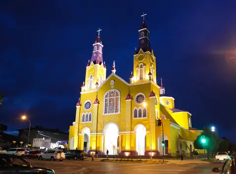
Structural fragility became urgent in March 2002 when a fierce storm collapsed Chonchi's wooden bell tower, exposing advanced rot and structural fatigue beneath exterior shingle skins. Together, the 16 inscribed churches cover just 13.8977 hectares without formal buffer zones around surrounding town streets, leaving urban expansion, signage and rising tourism pressing on historic seaside vistas. Earthquakes and fires have also reshaped island towns repeatedly. An 1837 tremor devastated Castro, leaving only 1,243 residents by 1907. Later, the catastrophic 1960 earthquake and tsunami shattered coastal palafitos and the 1912-to-1960 Ancud-Castro railway (commemorated in Castro's Plazuela del Tren park), before a December 2021 fire destroyed numerous timber buildings in Castro.
Since 2003, the Chilean government and the Inter-American Development Bank have financed major conservation work across the archipelago, rescuing failing tower facades, documenting traditional carpenter joints and fighting xylophage wood-boring insects. Conservation teams also confront an acute material bottleneck: remaining old-growth larch and cypress forests are legally protected against logging, pushing restorers to test alternative regional timber species with comparable weather resistance while transferring ancestral mortise-and-peg skills to younger apprentices. Archaeologists further note that untouched soil directly beneath several church platforms may conceal pre-Hispanic indigenous ritual layers waiting for careful future investigation.
Access Zones Across the Chiloé Archipelago
Because the 16 listed sanctuaries span Chiloé Island and four smaller eastern islands, grouping visits into coastal road loops and short channel ferry crossings makes local parish schedules manageable.
| Complex Zone | Key Highlights | Access & Ticket Rule |
|---|---|---|
| Castro & Central Peninsula (San Francisco, Nercón, Rilán) | Twin-towered Iglesia San Francisco on Plaza de Armas, coihue-framed Nuestra Señora de Gracia in Nercón and Rilán coastal church near Gamboa palafitos and Regional Museum | Active parish buildings open during daytime services and visitor schedules; small voluntary maintenance donations often requested at entry |
| Dalcahue & Northern Coastal Loop (Dalcahue, Tenaún, San Juan, Colo) | Multi-pinnacle Tenaún church, seafront shingle facades and open grassy landing esplanades east of Route 5 | Accessible by paved and secondary coastal roads; village caretakers hold keys outside set liturgical periods |
| Quinchao Island (Achao, Quinchao) | Historic Achao wooden nave vaulting and Quinchao church overlooking a wide coastal pilgrimage meadow | Reached via frequent short vehicle ferries from Dalcahue; open according to local parish and foundation caretaker schedules |
| Southern & Outer Islands (Chonchi, Vilupulli, Lemuy, Chelín, Caguach) | Chonchi's storm-restored facade, three Lemuy island churches (Aldachildo, Ichuac, Detif) and small outer-island chapels | Lemuy connects via regular channel ferry south of Chonchi; Chelín and Caguach require scheduled boat services from Quinchao or Dalcahue |
Three Carpentry and Siting Details Inside Chiloé's Churches
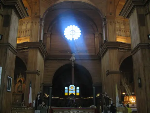
- Inverted-Hull Timber Vaulting and Pegged Joints: Look straight up inside the central nave of Achao or Nercón to follow curved wooden ceiling ribs built like upturned ship frames. Chilote shipwrights fastened heavy beams with carved hardwood dowels rather than rigid iron bolts so spires and roofs flex during earthquakes and coastal storms without splitting.
- Overlapping Tejuela Wood Shingles: Walk around the exterior flanks of Tenaún, Dalcahue or Quinchao to examine overlapping split cypress and larch shingles shaped with flat, rounded or pointed lower edges. Acting as replaceable rain armour, these courses shed heavy Pacific downpours before moisture penetrates interior boarding.
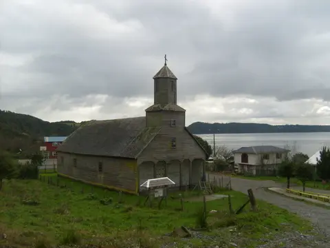
- Seaward Tower Beacons and Coastal Esplanades: Stand on the open grass meadow before Detif or Quinchao with your back to the front portal. Every sanctuary faces straight out over an anchorage or tidal bay, sited high enough above high tides to protect timber sills while serving as a daytime navigation marker for passing boats.
Seasonal Timing Across Chiloé and Mainland Chile
Warmer, drier weather peaks in January and February when mean daily temperatures in Castro reach 15.9 degrees Celsius and rainfall dips to 39.7 millimetres, offering clear views of painted facades and calmer crossings to outer islands such as Chelín and Caguach. Winter months around July average 7.3 degrees Celsius averaging 293.1 millimetres of rain, demonstrating how steeply pitched tejuela roofs perform in fierce Pacific weather while indoor services carry on by timber-warmed naves. Base yourself in Castro or Ancud for two to three days to pair parish circuits with the Museum of Modern Art of Chiloé and coastal wetlands such as the Chepu basin Nature Sanctuary. From El Tepual International Airport (PMC) near Puerto Montt, continue north up mainland Chile using our guide to Santiago or browse additional South American heritage monuments in the UNESCO World Heritage Atlas.