


























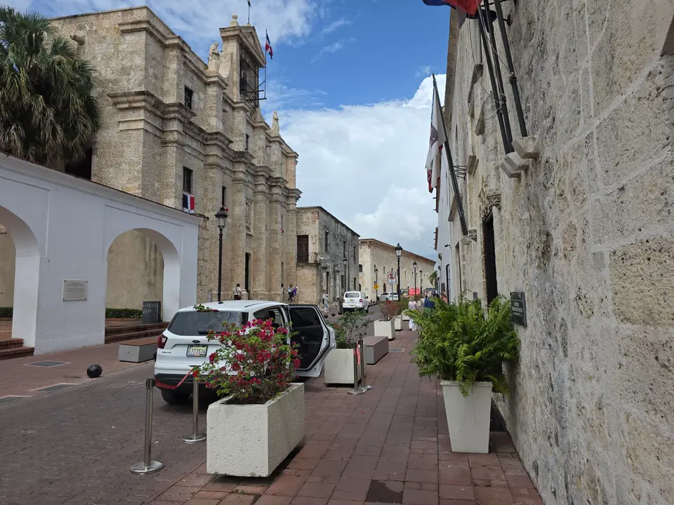
Quick Field Data
- UNESCO Inscription: 1990 (Cultural, Criteria ii, iv, vi; Property ID 526).
- Scale & Footprint: 106-hectare (1.06 km² or 0.41 sq mi) walled historic district along the western side of the Ozama River containing 32 streets across 116 rectangular blocks and more than 300 historical sites.
- Access & Ticketing: Open historic neighbourhood (Zona Colonial / La Zona) in the Distrito Nacional of Santo Domingo (postal code 10210); check the official site for entry tickets to the Alcázar de Colón, Fortaleza Ozama, Cathedral, and Museo de las Casas Reales.
- Arrival Logistics: Located at 18.4724°N, 69.8858°W at the mouth of the Ozama River on the south coast of Hispaniola Island in the capital of the Dominican Republic.
From Bartholomew Columbus's 1498 Outpost to Nicolás de Ovando's 1502 Grid
Situated at 18.4724 degrees north and 69.8858 degrees west at the mouth of the Ozama River along the southern shoreline of Hispaniola, the Colonial City of Santo Domingo (known in Spanish as Ciudad Colonial, Zona Colonial, or colloquially as "La Zona") forms the historic central neighbourhood of Santo Domingo de Guzman, the national capital of the Dominican Republic. Following the 1492 arrival of Christopher Columbus on Hispaniola, Spanish settlers established the earliest permanent urban settlement of the "New World" and the administrative capital of the West Indies along the banks of the Ozama. Initially settled on the east side of the Ozama River in 1496 and officially founded in 1498 by Christopher Columbus's brother Bartholomew Columbus by order of the Catholic kings, the early eastern settlement was devastated in 1502 by a violent Atlantic hurricane whose victims included Francisco de Bobadilla.
In the aftermath of the 1502 hurricane, the new colonial governor, Nicolás de Ovando, relocated the settlement and transferred all of its governing institutions to the west bank of the river. Working alongside his successor Diego Colón (son of Christopher Columbus), Governor Nicolás de Ovando decided in 1502 to lay out the new city on a regular checkerboard grid pattern radiating outward from the central Grand Place (Plaza Mayor, today Parque Colón). Covering an enclosed area of 106 hectares (1.06 square kilometres or 0.41 square miles) within the Distrito Nacional (postal code 10210), this 1502 grid comprises 32 intersecting streets that criss-cross 116 rectangular blocks of one- and two-level masonry buildings constructed of stone, brick, and earthen walls. Because the original street scale and block plan introduced by Nicolás de Ovando remained virtually intact, the checkerboard layout of Santo Domingo became the urban planning model for almost all Spanish colonial town planners across the Americas.
Throughout the early 16th century, the port at the mouth of the Ozama River functioned as the primary Spanish base of operations and point of departure for the exploration and conquest of the Caribbean islands and the American mainland. From the harbour of Santo Domingo sailed famous expeditions led by conquistadors including Ponce de Leon, Juan de Esquivel, Hernán Cortés (Herman Cortes), Vasco Núñez de Balboa, and Alonso de Ojeda. Although the political and economic pre-eminence of the island colony gradually declined after Spanish attention shifted toward the newly conquered mainland territories of Mexico, Peru, and wider Latin America, the city retained its strategic Caribbean defences. In 1655, English forces commanded by officers William Penn and Robert Venables besieged Santo Domingo; Spanish troops commanded by Don Bernardino de Meneses y Bracamonte (the Count of Peñalva, serving as Captain General of the Colony) successfully thwarted the 1655 English invasion. Following this victory, colonial engineers modified the western defensive wall (muralla), extending the rampart to encompass the pre-existing fort of Fuerte San Genaro and creating the bastion known as El Baluarte del Conde and the gateway of Puerta del Conde (translated as "Gate of the Count"), named in honour of the Count of Peñalva, which marked the western boundary of the city and the entrance to the hinterland until the late 19th century.
City of Firsts: Gothic Monuments, Calle Las Damas, and the Alcázar de Colón
Celebrated as the "City of firsts" in the Americas and the only surviving urban centre that preserves its late 15th- and early 16th-century spatial character, the Colonial City of Santo Domingo housed the first European religious, academic, medical, military, and administrative institutions established in the New World. Anchoring the religious core is the Saint Mary of the Incarnation Cathedral (Catedral de Santa María la Menor, the Cathedral of Santo Domingo), which borders the southern edge of Parque Colón, a central public square adorned since the late 19th century with a bronze statue of Christopher Columbus. Across the 116 blocks stand the ruins of the Saint Francois Monastery (Monasterio de San Francisco), the site of Saint Thomas Aquinas University (the first university in the Americas), the ruins of the Nicholas de Bari Hospital (the continent's first hospital), and the customs house and Casa de Contratación.
Just east of Parque Colón runs the cobblestoned thoroughfare of Calle Las Damas (Las Damas Street), laid out in 1502 as the oldest paved street in the New World. Bordering Calle Las Damas is the Fortaleza Ozama (the fortress of Santo Domingo, the earliest permanent military fortress in the Americas) together with its medieval-style keep, the Torre del Homenaje, overlooking the Ozama River. Along this same historic street stand the Casa de Bastidas (which today houses a children's museum), the building housing the French Embassy (traditionally identified as the residence of Hernán Cortés), the Casa de Ovando (once the residence of Governor Nicolás de Ovando, now operating as the luxury hotel Hodelpa Nicolas de Ovando), the Dominican Republic's National Pantheon, and the 16th-century Museo de las Casas Reales, housed inside the former palace of the colonial governors and the Audiencia building.
At the northern end of Calle Las Damas opens the restored and expanded Plaza de España, bordered on one side by Las Atarazanas (the former naval yard and customs warehouse, which formed one of the earliest commercial centres in the Americas and now houses a museum, shops, and restaurants) and on the other by the Alcázar de Colón. Built originally in 1510 as the fortified palace of the Columbus family starting under Christopher Columbus's son Diego Colón, the stone palace of the Alcázar de Colón was restored during the Trujillo era in the early 1950s (specifically to its current appearance in 1952) and now operates as a museum displaying period furniture and decorative arts. Running west from Parque Colón straight to the Puerta del Conde and Parque Independencia is the pedestrian-only Calle del Conde, lined with early 20th-century commercial buildings, while just north of the walled zone runs the traditional commercial corridor of Avenida Duarte.
Walking the 116 Blocks Between the Ozama River and Puerta del Conde
From 1990, the UNESCO World Heritage Atlas in 1990 under Criteria ii, iv, and vi and studied by Dominican historians including Luis Alemar (1980), Américo Moreta Castillo (2007), and Julio Amable González Hernández (2007), the 106-hectare Colonial City of Santo Domingo encompasses more than 300 historical sites within its perimeter of walls, bastions, and forts, while adjacent to the historic core lies the Port of Ozama developed by Sans Soucí Ports S.A. with a cruise terminal and marina. Because the entire 1.06-square-kilometre district is flat and compact, visitors can easily explore its 32 streets on foot. You can locate Hispaniola Island and the mouth of the Ozama River on our interactive world map. Coral limestone walls frame the Caribbean sea breeze.
- Inspecting the Gothic portals of Catedral de Santa María la Menor: Begin at Parque Colón beside the bronze Christopher Columbus monument from the late 19th century to study the Gothic vaults and carved stone facade of the Cathedral of Santo Domingo (Saint Mary of the Incarnation).
- Walking the 1502 cobblestones of Calle Las Damas to Plaza de España: Follow the New World's oldest paved street past the Fortaleza Ozama and its Torre del Homenaje, the Casa de Bastidas, the house associated with Hernán Cortés, the Casa de Ovando, the National Pantheon, and the Museo de las Casas Reales to reach the 1510 Alcázar de Colón and Las Atarazanas on Plaza de España.
- Tracing Calle del Conde to the 1655 bastion of Puerta del Conde: Walk west along pedestrian Calle del Conde, stopping to view the ruins of the Nicholas de Bari Hospital and the Monasterio de San Francisco before reaching El Baluarte del Conde and the Puerta del Conde at Parque Independencia.
