


























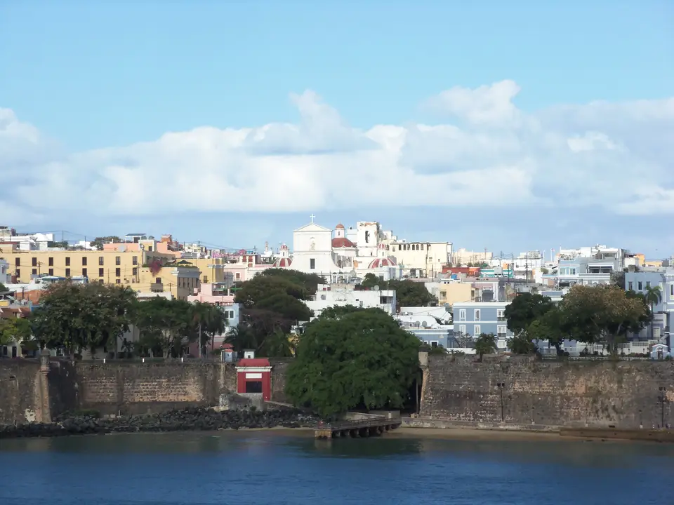
Quick Field Data
- UNESCO Inscription: 1983 (Criteria vi; Spanish Caribbean military architecture and strategic port fortifications constructed between the 16th and 19th centuries).
- Scale & Footprint: Occupies the western half of the 47-square-mile Isleta de San Juan, encompassing La Fortaleza, Fort San Felipe del Morro, Fort San Cristóbal, the historic city walls, and Fort San Juan de la Cruz across the bay in Toa Baja.
- Access & Ticketing: Administered primarily by the National Park Service as the San Juan National Historic Site alongside the Commonwealth government at La Fortaleza; verify entry passes via the official portal.
- Arrival Logistics: Located roughly 8 miles (12.9 kilometres) west of Luis Muñoz Marín International Airport in Carolina, or directly across the San Antonio Channel from Fernando Luis Ribas Dominicci Airport, with the AcuaExpreso ferry linking Old San Juan to Cataño and Hato Rey.
Atlantic Geopolitics and the Fortification of the Isleta de San Juan
Founded by Spanish colonists in 1521 after Juan Ponce de León relocated the initial settlement from inland Caparra (established in 1508), the city of San Juan Bautista occupied the western tip of a rocky islet guarding the entrance to San Juan Bay. The narrow harbour channel offered deep, sheltered anchorage for Spanish merchant fleets and treasure galleons crossing the Atlantic Ocean, turning the settlement into a primary military target for rival European empires. Every headland demanded heavy artillery.
Construction of the defensive network began in the 16th century with La Fortaleza, officially known as El Palacio de Santa Catalina, overlooking the bay shore, followed by the fortification of the rocky northwestern promontory at Fort San Felipe del Morro. This initial system faced immediate tests when Sir Francis Drake attacked San Juan in 1595 and suffered a decisive defeat off the harbour mouth. Three years later, in 1598, George Clifford, Earl of Cumberland, bypassed the harbour guns by landing troops east of the islet and capturing the city for several months until dysentery forced a British withdrawal. In 1625, Dutch commander Boudewijn Hendricksz sailed directly into the bay, besieged El Morro, and burned much of the town before retreating.
These successive assaults prompted the Spanish monarchy to enclose the entire western end of the islet within a continuous circuit of heavy sandstone masonry walls. Between 1635 and 1641, Captain General Íñigo de la Mota Sarmiento supervised the construction of major landward and bayside ramparts pierced by five fortified gates: the preserved Puerta de San Juan (1635), Puerta de Santiago, Puerta de San José, Puerta de Santa Rosa, and Puerta de San Justo. To prevent future landward invasions across the eastern ridge of the islet, Spanish military engineers erected the vast outworks of Fort San Cristóbal during the 17th and 18th centuries, transforming San Juan into one of the most heavily defended bastioned ports in the Americas. That perimeter stood firm when British forces under Sir Ralph Abercromby landed in 1797 and failed to breach the eastern defences, and it later endured the May 1898 naval bombardment by Admiral William T. Sampson during the Spanish-American War before the Treaty of Paris transferred Puerto Rico to the United States.
Bastions, Hornworks, and Colonial Masonry across Old San Juan
The inscribed monument integrates European Renaissance and Baroque military engineering with the steep coastal topography of a tropical island. At the northwestern tip of the islet, Fort San Felipe del Morro rises in successive tiers of sandstone batteries, casemates, and hornworks that command both the open Atlantic approach and the narrow harbour channel directly opposite the small square fort of El Cañuelo (Fort San Juan de la Cruz) in nearby Toa Baja. On the northeastern heights, Fort San Cristóbal spreads across a wide series of dry moats, ravelins, underground tunnels, and counter-guards designed to sweep the landward isthmus of Puerta de Tierra with interlocking crossfire, supplemented farther east by the smaller coastal redoubt of Fortín de San Gerónimo near El Escambrón.
Along the southwestern bay shore, La Fortaleza demonstrates the evolution of a 16th-century circular tower fortification into a formal governorate palace. Serving continuously since the 16th century as the official residence of the Governor of Puerto Rico, the complex blends thick defensive bastions facing the water with neoclassical staterooms, interior courtyards, and terraced gardens. Within the defensive perimeter of San Juan Antiguo, the urban streetscape preserves a rectilinear grid of narrow thoroughfares paved with blue cobblestone cast from furnace slag that arrived in the holds of Spanish ships as ballast.
Flanking these blue cobblestone streets stand two-storey masonry residences, civic halls, and ecclesiastical landmarks that anchored the colonial capital. Just inside the walls near La Fortaleza sits Casa Blanca, constructed as the ancestral family house of Juan Ponce de León, alongside the 1523 San José Church and the Cathedral of San Juan Bautista, begun in the 1520s, where the explorer's marble tomb rests today. In the upper military quarter near El Morro, the expansive 19th-century Cuartel de Ballajá (Ballajá Barracks) frames a monumental quadrangle that now houses the Museum of the Americas and cultural institutions, while the municipal Alcaldía (City Hall), modelled on Madrid's city hall between 1604 and 1789, faces the central Plaza de Armas alongside the Diputación Provincial and Real Intendencia buildings.
Field Logistics and Navigation around the Walled Promontory
Exploring the fortifications and colonial districts of Old San Juan requires navigating steep gradients, exposed coastal ramparts, and dense historic street networks across the western islet.
- Approaching the Historic District: Old San Juan occupies the western half of the Isleta de San Juan, connected to the Puerto Rican mainland by bridges and a causeway across the San Antonio Channel and Condado Lagoon. From Luis Muñoz Marín International Airport (8 miles or 12.9 kilometres east in Carolina), travellers follow Puerto Rico Highway 26 (Román Baldorioty de Castro Expressway) through Santurce and Puerta de Tierra, while the Metropolitan Bus Authority (AMA) operates 30 fixed bus routes and the AcuaExpreso ferry links the bayside piers with Cataño and Hato Rey.
- Sequencing the Fortifications: Begin at the eastern landward defences of Fort San Cristóbal to examine how Spanish engineers fortified the high ridge against infantry advances, then follow the northern wall walk past the coastal cliffside cemetery of Santa María Magdalena de Pazzis toward the open esplanade of Fort San Felipe del Morro. From El Morro, descend south past the Ballajá Barracks and the Cathedral of San Juan Bautista to trace the southern bay wall through the 1635 Puerta de San Juan toward the exterior bastions of La Fortaleza and La Princesa.
- Climate and Coastal Weather Conditions: San Juan experiences a tropical monsoon climate moderated by Atlantic trade winds, with warm temperatures year-round and frequent passing showers. The open stone terrepleins of El Morro and San Cristóbal offer minimal shade under intense midday sun, while sudden Atlantic rain squalls can make the historic blue slag cobblestones and steep masonry ramps slippery underfoot.
Metropolitan Expansion and Conservation Context
While the historic core remained confined within its stone walls for over three centuries, the late 19th century initiated a major urban transformation when the Spanish military demolished sections of the eastern landward ramparts in 1897 to relieve overcrowding. Following the 1878 steam tramway built by Pablo Ubarri Capetillo and the 1951 municipal annexation of Río Piedras, modern San Juan expanded across 18 barrios housing 342,259 residents as of the 2020 census, stretching from the Art Deco and Modernist avenues of Condado, Miramar, and Santurce to the financial district of Hato Rey (the Milla de Oro) and the University of Puerto Rico campus designed in part by Henry Klumb and Rafael Carmoega.
Despite intense metropolitan growth, severe traffic density on the surrounding expressways, and the impact of major Atlantic tempests such as Hurricane Maria in 2019 recovery reports, the fortified enclave of San Juan Antiguo retains its structural coherence and historical legibility across the western promontory. Ongoing preservation efforts by the National Park Service and the Institute of Puerto Rican Culture protect the sandstone bastions, sentry boxes, and colonial streetscapes against coastal salt erosion and heavy cruise ship tourism. Visitors can map the full defensive circuit through our UNESCO World Heritage Atlas before exploring the wider architectural heritage of the Caribbean basin.
