


























Quick Field Data
- UNESCO Inscription: 1986 (Criteria vii, ix; living Macaronesian relict of the humid subtropical Tertiary laurisilva forest sustained by trade-wind cloud condensation and permanent mountain streams).
- Scale & Footprint: Covers 40 square kilometres (15 square miles, or roughly 11 percent of La Gomera) across a central volcanic plateau between 790 and 1,487 metres elevation, extending into all six municipalities of La Gomera in the Canary Islands, Spain.
- Access & Ticketing: Declared a Spanish National Park in 1981 (IUCN Category II); open year-round across its network of 18 footpaths with tourist accommodation located just outside the park boundary, so check the official site.
- Arrival Logistics: Situated across the central and northern highlands of La Gomera within Spain's Canary Islands off northwest Africa, crossed by regional mountain roads and 18 trekking footpaths.
Tertiary Relict Forests, Trade-Wind Fog, and the Legend of Gara and Jonay
Rising out of the Atlantic Ocean not far off the northwest coast of Africa, the high volcanic island of La Gomera (among the seven islands forming Spain's Canary Islands archipelago) receives the moisture-laden rains and clouds arriving from the west across its windward central peaks. While climatic changes at the end of the Tertiary period wiped out the warm temperate and subtropical rainforests that once covered almost all of Southern Europe and North Africa, living relict remnants of this ancient Tertiary vegetation survived across the Macaronesian islands of the Canaries alongside Madeira (Portugal) and the Azores. Declared a national park in 1981 and inscribed on the UNESCO World Heritage List in 1986, Garajonay National Park protects 40 square kilometres (15 square miles, some 11 percent of the island), extending into all six municipalities on La Gomera across the central highlands.
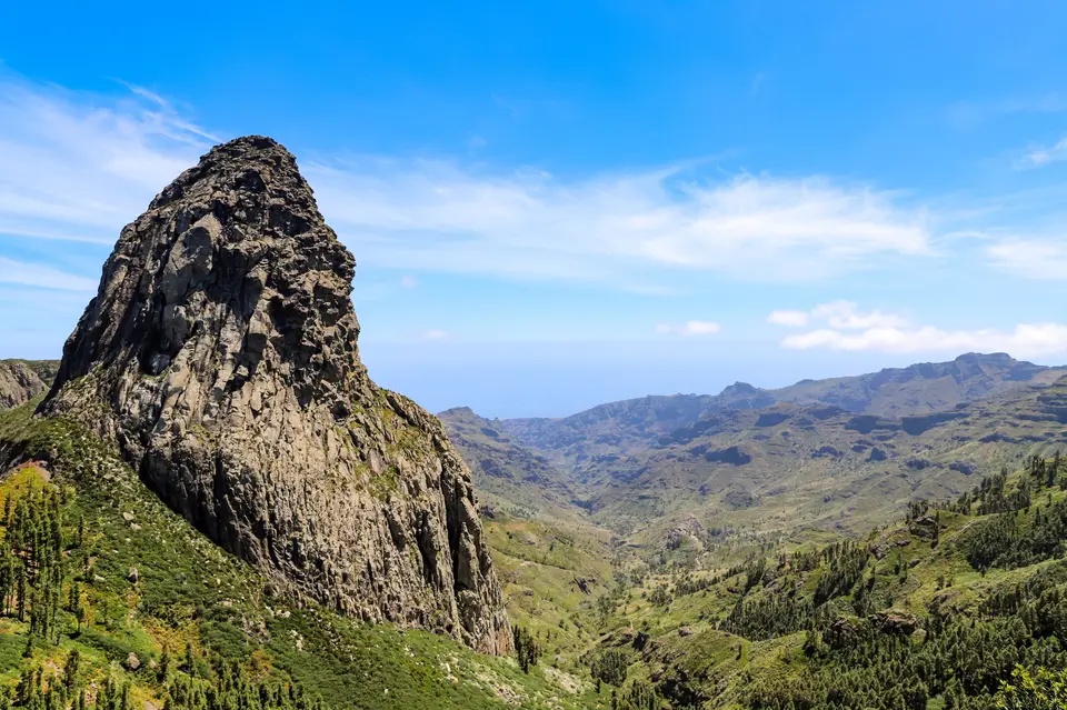
The park crowns a central plateau whose altitude ranges from 790 to 1,400 metres (2,590 to 4,590 feet) above sea level and takes its name from the Garajonay rock formation, which forms the island's highest summit at 1,487 metres (4,879 feet). Across the park and island rise massive eroded volcanic rocks (former volcanic conduits carved by erosion over millions of years) such as Roque Ojila alongside Roque de Agando, Roque de La Zarcita, and the table-like Fortaleza (meaning fortress in Spanish), which the native Guanche islanders revered as sacred places and used as ideal refuges when attacked. Thick mist shrouds the peaks.
Although linguists analyse the Guanche word Garajonay as meaning high crag and note that the earliest written version of the legend appeared in 1924 in the newspaper Gaceta de Tenerife, popular island lore names the peak and park after the hapless lovers Gara and Jonay, evoking Romeo and Juliet alongside Hero and Leander. In the tale, Gara, a princess of Agulo on La Gomera, gazed into the waters of the Chorros del Epina during the unmarried girls' divination festival of Beñesmén; when the clear water reflected her image before the sun's reflection temporarily blinded her, a wise man named Gerián warned her to avoid all fire lest it consume her. When Gara fell in love with Jonay, son of the Guanche mencey (king) of Adeje on Tenerife who arrived for the ceremonies, the volcano Teide visible from La Gomera erupted in apparent disapproval and their parents broke the engagement; after Jonay swam back across the channel by night to rejoin his beloved, the trapped lovers took their own lives together on the mountain.
Valley Laurisilva, Slope Heath, and Endemic Canarian Pigeons
Laurel forest (laurisilva) covers some 70 percent of Garajonay National Park, surviving within an otherwise arid island solely because of the mild year-round temperatures (which fluctuate little during the year), high humidity, and persistent sea of fog and mist that shrouds the mountain peaks and gives the woodland its distinctive character. Condensing onto the dense evergreen canopy, these vital fogs generate the moisture that feeds La Gomera's network of springs and permanently flowing streams, the best-preserved freshwater stream system in the Canary Islands. Key laurel species include the Azores laurel (Laurus azorica, called in Portuguese louro or louro-da-terra as well as loureiro and louro-de-cheiro) together with the Canary laurel (Laurus novocanariensis).
Rather than a single uniform woodland, Garajonay encompasses several distinct forest varieties shaped by altitude and orientation across the plateau. In the most humid, sheltered valleys oriented toward the north grows the valley laurisilva, a true subtropical rainforest containing the largest laurel trees and the richest botanical complexity. At higher altitudes with less shelter from wind and sun, delicate species disappear to form the slope laurisilva (laurisilva de ladera), while across the drier southern slopes the forest shifts into a mix of beech and heather adapted to a less humid atmosphere where trade-wind clouds dissipate more rapidly above the southern ravines.
This lush Tertiary refuge harbours a rich biota of understory plants alongside invertebrates, bats, reptiles, amphibians, and birds, with a high proportion of species unique to La Gomera, the Canary archipelago, or the wider Macaronesian islands. Resident herpetofauna include two reptile species, the Gomeran lizard (Gallotia gomerana) and the Gomeran skink (Chalcides viridanus), alongside the stripeless tree frog (Hyla meridionalis). Designated by BirdLife International as an Important Bird Area (IBA), the national park is celebrated as a premier sanctuary for observing the two endemic Canarian pigeons, namely the laurel pigeon (Columba junoniae) together with Bolle's pigeon (Columba bollii), as well as island canaries alongside plain swifts, Barbary partridges, Berthelot's pipits, and Eurasian sparrowhawks that nest and forage across the plateau and wooded valleys.
Trekking the Eighteen Footpaths and Volcanic Rock Viewpoints
Welcoming nearly 450,000 tourists every year (with all visitor accommodation situated just outside the park's perimeter in the surrounding island municipalities), Garajonay is crossed by an extensive network of 18 official footpaths that make trekking the primary activity on La Gomera and allow hikers to experience the sharp ecological contrast between the arid coastal slopes and the mist-wrapped highland canopy where Tertiary vegetation thrives year-round.
- Trekking the Northern Valley Laurisilva and Streams: Follow the northern footpaths descending into the humid, mist-wrapped valleys to walk beside permanently flowing mountain streams and springs beneath towering specimens of Canary laurel (Laurus novocanariensis) and Azores laurel (Laurus azorica), where trade-wind fog condenses directly onto the evergreen canopy to sustain the lush Tertiary vegetation and the Chorros del Epina springs associated with the Guanche divination festival of Beñesmén and the wise man Gerián.
- Crossing the Central Plateau to the 1,487-Metre Garajonay Peak: Hike across the 790-to-1,400-metre plateau where valley laurisilva transitions into wind-exposed slope laurisilva (laurisilva de ladera) and southern beech-and-heather woodland, ascending to the 1,487-metre summit of the Garajonay rock formation for panoramic views across the six island municipalities toward the volcano Teide on neighbouring Tenerife.
- Observing Endemic Pigeons and Volcanic Rock Formations: Pause along the 18 forest footpaths within the BirdLife International Important Bird Area to watch for Bolle's pigeon (Columba bollii) alongside the laurel pigeon (Columba junoniae), Gomeran lizards (Gallotia gomerana), Gomeran skinks (Chalcides viridanus), and stripeless tree frogs (Hyla meridionalis), and visit the viewpoints overlooking the massive eroded volcanic rocks of Roque de Agando (such as from the Mirador del Morro de Agando observation deck), Roque Ojila, Roque de La Zarcita, and the sacred Guanche refuge of Fortaleza.
Ecological Recovery after the 2012 Wildfire and Ongoing Protection
In August 2012, a severe forest fire burned 747 hectares (roughly 18 percent of Garajonay National Park) across the drier southern forest zones, prompting sustained ecological restoration and fire-prevention management across the six island municipalities of La Gomera. Because the laurel forest covers some 70 percent of the park and relies on uninterrupted cloud condensation to feed the island's permanent freshwater streams, ongoing conservation focuses on regenerating native laurisilva stands across the southern slopes while maintaining the humid northern valley rainforests and protecting the habitats of the Gomeran lizard, the Gomeran skink, and the two endemic Canarian pigeons. By restricting tourist lodging to outside the boundary and channelling the nearly 450,000 annual visitors along the 18 marked footpaths across the 40-square-kilometre plateau, park authorities safeguard the fragile Tertiary streams, cloud-fed laurel canopies, and threatened endemic species of the Macaronesian archipelago. Explore Garajonay alongside Madeira's laurisilva and other Atlantic island reserves in our UNESCO World Heritage Atlas.
