


























Quick Field Data
- UNESCO Inscription: 1989 (Natural, Criteria ix, x; established as a national park in 1976 and designated a Ramsar wetland on 22 October 1982).
- Scale & Footprint: 12,000 km² marine and coastal reserve between Nouakchott and Nouadhibou encompassing Saharan sand dunes, coastal swamps, shallow intertidal seagrass beds, and barrier islands including Tidra, Niroumi, Nair, Kijji, and Arguin.
- Access & Ticketing: Protected IUCN Category II reserve where motorboats are prohibited inside the marine zone; check the official site for desert track permits, park entry fees, and traditional Imraguen sailing excursions.
- Arrival Logistics: Located at 20.2347°N, 16.1089°W along the western Atlantic coast of Mauritania between the capital Nouakchott and the northern port city of Nouadhibou.
Where the Sahara Meets the Upwelling Waters of the Atlantic Ocean
Spanning 12,000 square kilometres along the Atlantic coast of Mauritania between Nouakchott and Nouadhibou at 20.2347 degrees north and 16.1089 degrees west, Banc d'Arguin National Park (known in Arabic as Ḥawḍ ʾArkīn and in French as Parc national du Banc d'Arguin) occupies the former mouth of the prehistoric Tamanrasset River on the Bay of Arguin. Established as a nature reserve in 1976 to safeguard natural resources, fisheries, and geological sites, designated a Ramsar wetland (Site 250) on 22 October 1982, and inscribed on the World Heritage List in 1989, the park protects a coastal frontier where wind-sculpted sand dunes of the Sahara meet one of the richest marine zones in Western Africa. Along the northern boundary, the Ras Nouadhibou peninsula (formerly Cap Blanc), which stretches 50 kilometres (31 mi) in length and reaches up to 13 kilometres (8.1 mi) in width while administratively divided between Morocco and Mauritania, shelters Dakhlet Nouadhibou (formerly Lévrier Bay), a natural harbour measuring 43 kilometres (27 mi) long by 32 kilometres (20 mi) wide at its broadest point. Farther south rises the coastline's only significant promontory, the 7-metre-high (23 ft) Cape Timiris, beyond which the regular shoreline continues toward the marshy mouth of the Senegal River.
Across the northern sector of Banc d'Arguin, the submarine geology forms a flat-topped carbonate platform developed in water depths under 10 metres below sea level and covered by mixed carbonate and siliciclastic sediments dominated by barnacles, mollusc remains, and wind-blown Saharan dust. These sediments accumulate into vast shoals where water depths remain less than 5 metres several dozen kilometres offshore before dropping at a sharp morphological step from 10 to 20 metres down to 30 to 50 metres, where benthic foraminifers, molluscs, and bivalve shell accumulations with aeolian silt cover the outer shelf. Along the central and southern edges of the outer shelf, fine quartzose silts form the Arguin and Timiris Mud Wedges, which began growing with early Holocene transgressional inundation over the past 9,000 years and are incised by submarine gullies and canyons toward the shelf break at 80 to 110 metres depth, while the southernmost Golfe d'Arguin forms a gentle homoclinal ramp with vast intertidal plains around Tidra Island. Oceanic trade winds blowing from the Canary Islands modify the dry continental harmattan along this 754-kilometre Sub-Canarian coastal zone, holding mean maximum temperatures between 28 °C in Nouadhibou and 32 °C in Nouakchott (while mean minimum temperatures range between 16 °C and 19 °C) and annual rainfall in Nouadhibou averages less than 30 millimetres between July and September.
Because these shallow coastal waters shelter some of the most pristine intertidal seagrass beds on earth, the marine zone sustains 45 species of fish alongside 11 shellfish species and varied molluscs, acting as a vital nesting and nursery ground for the entire western region. Onshore, coastal dune vegetation is sparse, though at the foot of the dune ridges grow large tamarisk bushes, dwarf acacias, and swallowworts, mixed in the central region with high grass, balsam, spurge, and spiny shrubs that sustain remnant populations of the threatened Dorcas gazelle (Gazella dorcas).
Two Million Wintering Waders, Marine Mammals, and Imraguen Fishing Traditions
Positioned along the East Atlantic Flyway and monitored across multi-decade ornithological surveys from 1980 to 2017 by researchers including Thomas Oudman, Hans Schekkerman, Amadou Kidee, Marc Van Roomen, Mohamed Camara, Cor Smit, Job Ten Horn, Theunis Piersma, and El-Hacen Mohamed El-Hacen, the vast intertidal mudflats of Banc d'Arguin provide wintering habitat for more than two million limicolous migrant birds arriving from Greenland, Siberia, and northern Europe. Researchers have documented at least 108 species of birds across the reserve, representing both the Palaearctic and Afrotropical realms. Wintering wader concentrations include up to one million dunlin, 500,000 bar-tailed godwit, 366,000 red knot, nearly 250,000 curlew sandpiper, 120,000 common redshank, nearly 98,000 ringed plover, 96,000 greater flamingo, 68,000 grey plover, 65,000 little stint, and 50,000 sanderling. Together with Cintra Bay and the Dakhla Peninsula to the north, the park is also a primary wintering ground for the Eurasian spoonbill. On the sandbanks and barrier islands of Tidra, Arguim (Arguin), Niroumi, Nair, and Kijji, between 25,000 and 40,000 breeding pairs belonging to 15 bird species form the largest colonies of waterbirds in West Africa, including white pelican, reed cormorant, Caspian tern, gull-billed tern, common tern, West African crested tern, grey heron, western reef heron, and Eurasian spoonbill.
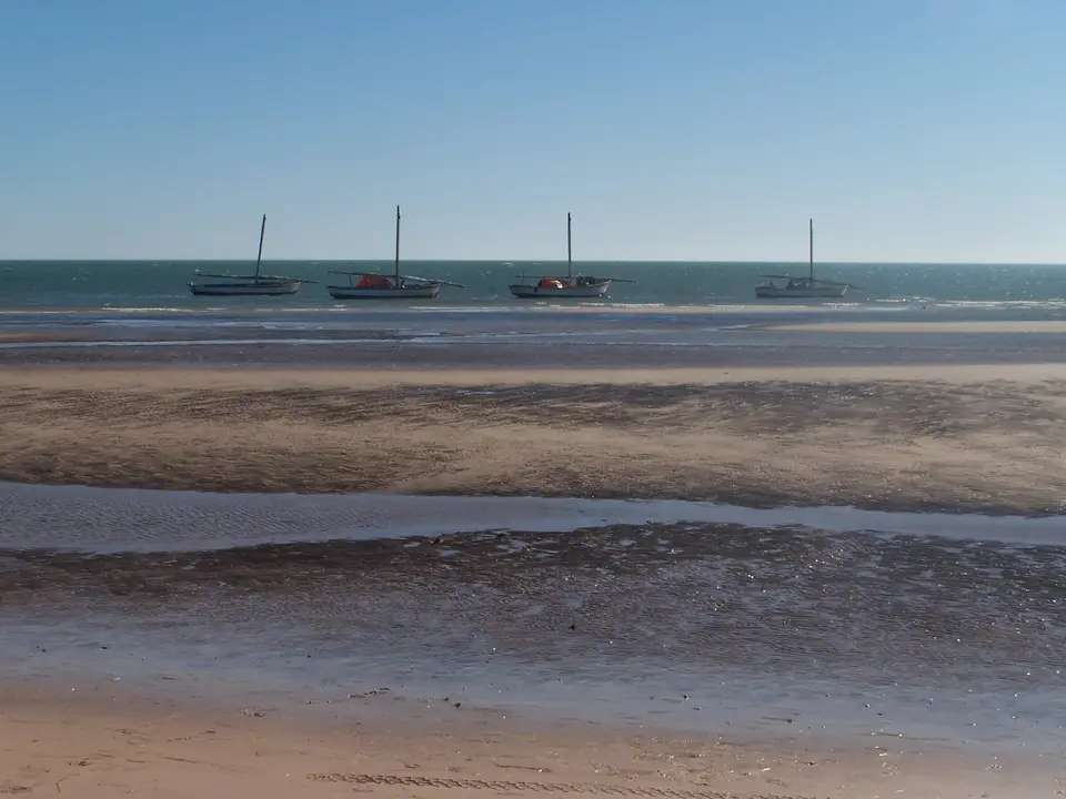
The shallows and outer banks also shelter threatened marine turtles, especially the green sea turtle (Chelonia mydas), alongside year-round populations of endangered marine mammals including Mediterranean monk seals, bottlenose dolphins, and Atlantic humpback dolphins, while killer whales (orca), pilot whales, Risso's dolphins, common and rough-toothed dolphins, fin whales, harbour porpoises, and the rare false shark ray (known only from this region) frequent the coastal waters. Within the park boundaries live approximately 500 Imraguen tribesmen distributed across seven villages. Under strict conservation rules that ban motorboats throughout the marine zone, only the indigenous Imraguen community is permitted to fish inside the park using traditional subsistence methods in which dolphins are used by the fishermen to attract and drive shoals of fish toward their nets.
Drawn by its productive fishing grounds and strategic coastal position, the European powers of Portugal, France, England, Brandenberg and Prussia, and Holland repeatedly contested the bay. Although Almoravid rulers governed Spain during the eleventh and twelfth centuries, direct maritime contact began in 1455 when the Portuguese established a trading fort on Arguin Island (50 kilometres or 31 mi southeast of Ras Nouadhibou, marking the earliest Portuguese outpost south of Cape Bojador in present-day South Morocco) and stationed a commercial factor at Ouadane inside the Adrar region to divert caravan gold before exporting up to 1,000 enslaved people per year to Europe and to Portuguese sugar plantations on São Tomé in the Gulf of Guinea. Following the 1580 merger of the Portuguese and Spanish crowns, Spain held the coast until 1638, when the Dutch took over and pioneered the trade in gum arabic harvested from acacia trees in Trarza and Brakna for textile pattern printing. In 1678, French forces expelled the Dutch and founded a permanent trading post at Saint Louis near the mouth of the Senegal River for the Compagnie Française du Sénégal, while local Moors (Maures) and the amir of Trarza played rival European powers against one another and demanded annual gift payments for gum arabic monopolies. After British forces expelled France in 1763, the Congress of Vienna in 1815 restored French sovereignty from Cap Blanc south to Senegal. One year later, on 2 July 1816, the French frigate La Méduse struck the shallow shoals of Banc d'Arguin at high tide, a shipwreck recounted by survivors Jean-Baptiste-Henri Savigny and Alexandre Corréard and depicted in Théodore Géricault's 1819 painting The Raft of the Medusa in the Louvre Museum in Paris.
Conservation Challenges and Field Expedition Logistics
After 1989, the UNESCO World Heritage List in 1989 and recognised by BirdLife International as an Important Bird Area (IBA), Banc d'Arguin National Park faces modern conservation challenges from illegal targeting of sharks and rays for the international market. Exploring the reserve requires self-sufficient vehicles capable of crossing desert tracks between Nouakchott and Nouadhibou, timed around coastal tides. You can trace the park's islands and shoals along the Mauritanian coast on our interactive world map. Silence rules the motor-free waters.
- Observing wintering waders at Cape Timiris and Tidra Island: Visit between October and March at low and rising tides around Cape Timiris and the intertidal flats facing Tidra Island, when incoming tides push hundreds of thousands of godwits, knots, dunlins, and greater flamingos onto the shoreline.
- Sailing on a traditional Imraguen boat: Arrange a non-motorised sailing excursion from one of the seven Imraguen coastal villages to navigate the shallow channels toward Tidra, Niroumi, Nair, and Kijji islands while keeping a respectful distance from nesting pelican, cormorant, tern, and spoonbill colonies.
- Exploring Arguin Island and Ras Nouadhibou: Travel to the northern sector around Ras Nouadhibou and Arguin Island to examine the site of the 1455 Portuguese trading fort and observe where Saharan sand dunes meet the shallow carbonate shelf of the Atlantic Ocean.
