


























Quick Field Data
- UNESCO Inscription: 1987 · Criteria (vii), (viii).
- Scale & Footprint: 180,500 ha (1,805 square kilometres or 697 square miles) along the Great Northern Peninsula on the west coast of Newfoundland, Canada.
- Access & Ticketing: Administered by Parks Canada; check the official site for visitor centre locations alongside seasonal trail permits and backcountry camping rules.
- Arrival Logistics: Located on the western coast of Newfoundland around Rocky Harbour alongside Woody Point, Trout River, and Bonne Bay.
Ophiolite Mantle Rock and Continental Drift in Stone
In 1987, the UNESCO World Heritage Atlas in 1987 under Criteria (vii) and (viii), Gros Morne National Park (Parc national du Gros-Morne) covers 180,500 hectares (1,805 square kilometres, or 697 square miles) along the Great Northern Peninsula on the western coast of Newfoundland in eastern Canada. Ancient mantle rock lies exposed here. Established as the Gros Morne National Park Reserve in August 1973 and formally enacted as a national park on 1 October 2005, it ranks as Atlantic Canada's second-largest national park after Torngat Mountains National Park (which spans 9,700 square kilometres, or 3,700 square miles). Geologists prize Gros Morne because its coastal cliffs alongside flat-topped highlands and deep glacial valleys expose an extraordinary cross-section of oceanic crust and rocks from the Earth's mantle, offering textbook physical proof of plate tectonics and continental drift.
The park's most striking geological feature is the Tablelands (Table Mountain), a stark, flat-topped massif situated between Trout River and Woody Point in the south-western sector of the park south of Bonne Bay alongside North Arm Mountain. Unlike the green boreal forest covering neighbouring hills, the Tablelands resemble a barren brown desert because they consist of ultramafic rocks (specifically peridotite together with serpentinite) belonging to the Upper Cambrian and Lower Ordovician ophiolites of the Bay of Islands Complex alongside the Little Post Complex and the Old Man Cove Formation. Originating in the Earth's mantle and forced upward over the ancient eastern North American continental margin through the obduction process of plate collision several hundred million years ago, these ultramafic rocks are high in iron (which weathers to a rusted brown surface over a dark green unweathered interior) while lacking the usual nutrients required to sustain plant life. Recognizing its global importance to plate tectonic theory, the International Union of Geological Sciences (IUGS) included the Mohorovičić discontinuity at Gros Morne among its assemblage of 100 global geological heritage sites in October 2022.
Complementing this exposed mantle rock are the ancient Precambrian quartz-feldspar gneisses and granites of the Long Range Mountains, a northern Appalachian outlier formed 1.2 billion years ago (with the Long Range Inlier or Basement Gneiss Complex reaching up to 1,550 million years in age) within the Humber Zone miogeocline of the Appalachian Grenville Orogeny. Along the western boundary of this inlier, stretching past Western Brook Pond and St. Pauls Inlet as well as south of Portl Creek Pond, thrust faults from the Devonian and Ordovician periods push crystalline rocks over Cambrian and Ordovician carbonate strata and the Lower Palaeozoic Humber Arm Allochthon. Along the shore between Western Brook Pond and Humber Arm (Bay of Islands), the coastal Rocky Harbour mélange displays Lower to Middle Ordovician blocks of greywacke alongside quartzite, dolomite shale, chert, and limestone embedded in a scaly shale matrix of black alongside green and red hues. At Green Point, coastal cliffs define the Global Boundary Stratotype Section (GSSP) for the Tremadocian stage and the base of the entire Ordovician system, studied by geologists Robert Stevens and Harold Williams, with rock and fossil collection strictly limited to research purposes.
Glaciated Fjords alongside Western Brook Pond
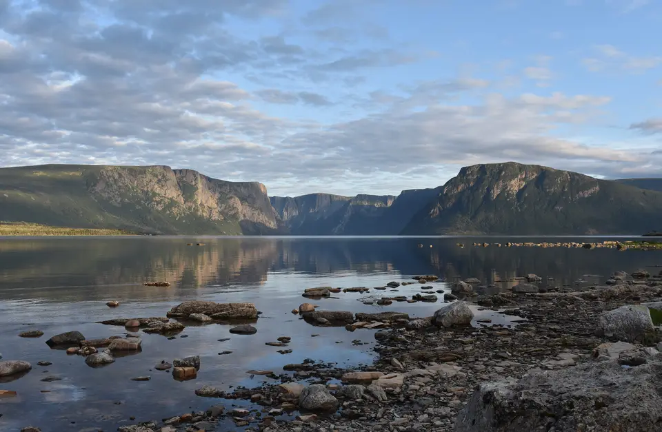
During the late Pleistocene glaciation spanning from 25,000 down to roughly 10,000 years ago, an ice cap flowed radially across the island of Newfoundland, scouring deep fjords such as Bonne Bay and carving sheer glacial valleys through the Long Range Mountains. After the Pleistocene ice sheets melted, the crust that had been depressed beneath the heavy ice rebounded isostatically and cut off the outlet to the sea at Western Brook Pond. This 16-kilometre-long (9.9-mile) narrow trench then filled with pure freshwater, creating a landlocked freshwater fjord accorded the top water-purity rating for natural lakes. Cascading into Western Brook Pond is Pissing Mare Falls, which ranks as eastern North America's tallest waterfall and the 199th highest in the world, framed by dominant granitic gneiss cliffs and westernmost calcareous sedimentary shores.
Across the park, soils vary widely because they developed on many distinct types of bedrock. In the north-east, stony sandy loams of the Silver Mountain soil association formed on glacial till lying over granite alongside granitic gneiss and schist, mirrored farther west by the St. Paul's Inlet association. In the south-east, sedimentary rocks including dolomitic limestone support the stony sandy loams of the North Lake association, while a narrow coastal band features shallow loams of the Cox's Cove association over shale alongside slate together with limestone and sandstone. North of Bonne Bay, Gull's Marsh peat soils and Sally's Cove coarse soils dominate the coastal strip, interrupted around Rocky Harbour by Wood's Island clay soils. South of Bonne Bay, the ultramafic Tablelands carry stony, nutrient-poor soils of the Serpentine Range association, while nearby mafic uplands support more fertile related soils capable of sustaining forest growth.
Rising within the Precambrian Long Range Inlier alongside Mount Big Level is the park's namesake peak, Mount Gros Morne (Gros Morne Mountain), which reaches 806 metres (2,644 feet) as the second-highest mountain peak on Newfoundland. In French, the name translates as "large mountain standing alone" or "great sombre," overlooking the coastal lowlands alongside alpine plateaus together with sheer cliffs and pristine lakes that define the park's glacial scenery.
Island Wildlife and Coastal Hiking Trails
Gros Morne supports a wide range of marine and terrestrial wildlife across its coastal shores alongside bogs, interior forests, and alpine plateaus. Eastern moose, descended from stock brought to Newfoundland from the Maritimes around 1900, are especially prominent across the park, with Parks Canada studies finding moose densities here five to 20 times greater than in comparable mainland regions of Canada. Sharing the uplands and forests are the endemic Newfoundland caribou (Rangifer tarandus terranovae) together with the Newfoundland black bear (Ursus americanus hamiltoni) and the Canada lynx (Lynx canadensis). Common smaller mammals include Arctic foxes alongside red foxes, beavers, American red squirrels, together with river otters and snowshoe hares, while alpine uplands support rock ptarmigan and willow ptarmigan alongside coastal shorebirds and forest birds. In St. Pauls Inlet and offshore waters (particularly during the early-summer capelin run), visitors spot harbour seals and Atlantic white-sided dolphins and harbour porpoises, as well as fin whales alongside humpback whales together with killer whales, minke whales, and pilot whales.
Hiking is one of the primary ways to experience the park's geology and glacial valleys, with about 20 marked day-trip trails exploring both coastal and interior sectors. One of the most strenuous day hikes is the 16-kilometre trail over Gros Morne Mountain, also known as the James Callaghan Trail in honour of the former British Prime Minister who visited Newfoundland in 1976 (provoking a small local controversy when Callaghan did not hike the trail named in his honour). Experienced hikers also access the roadless interior via the multi-day Long Range Traverse linking Western Brook Pond to Gros Morne Mountain. Beyond its trails and the Bonne Bay Marine Station, the park featured in a 2011 short film for the National Parks Project and hosts cultural festivals such as the Gros Morne Theatre Festival alongside Writers at Woody Point together with Gros Morne Summer Music and the Trails, Tales and Tunes festival.
Together, these 20 day-trip trails and multi-day alpine routes allow visitors to walk directly across exposed oceanic crust, mantle peridotite, and glaciated fjord walls within a single protected coastal landscape.
- The Tablelands & Mohorovičić Discontinuity: Walk between Trout River and Woody Point across rusted-brown mantle peridotite and serpentinite recognized by the IUGS in October 2022 among the world's top 100 geological heritage sites.
- Western Brook Pond & Pissing Mare Falls: Cross the coastal bogs to the 16-kilometre freshwater fjord carved between 25,000 and 10,000 years ago and fed by the highest waterfall in eastern North America.
- Gros Morne Mountain & Green Point GSSP: Hike the 16-kilometre James Callaghan Trail over the 806-metre peak alongside the Long Range Traverse and inspect the global Ordovician boundary strata at Green Point.
