


























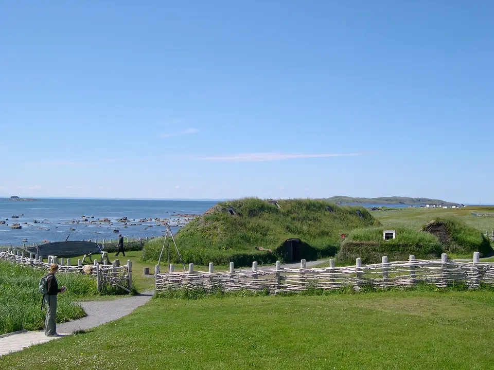
Quick Field Data
- UNESCO Inscription: 1978 · Criterion (vi)
- Scale & Footprint: 7,991 hectares (roughly 8,000 ha / 31 sq mi of land and sea) protecting eight 11th-century Norse turf structures and five Indigenous occupation layers overlooking Epaves Bay
- Access & Ticketing: Managed by Parks Canada; admission tickets at the visitor centre cover the museum exhibits, the boardwalk across the reburied Norse mounds, and the full-scale sod reconstructions
- Arrival Logistics: Located near St. Anthony at the northernmost tip of the Great Northern Peninsula of Newfoundland (Newfoundland and Labrador), overlooking the Strait of Belle Isle
Epaves Bay Topography, Turf-and-Timber Construction, and the Eight Norse Halls
At the windswept northern extremity of the Great Northern Peninsula on the island of Newfoundland, facing the icebergs and cold currents of the Strait of Belle Isle, L'Anse aux Meadows National Historic Site encompasses 7,991 hectares (roughly 8,000 hectares of coastal land and sea) near St. Anthony in the province of Newfoundland and Labrador. Cold winds sweep this treeless coast. Set along a narrow, raised marine gravel terrace overlooking a sedge peat bog and a small freshwater brook that empties into the shallow waters of Epaves Bay, this coastal meadow preserves the only undisputed archaeological site of pre-Columbian trans-oceanic European contact in the Americas outside Greenland.
Although the headland today consists of open, grassy lands, a setting reflected in the French-English name L'Anse aux Meadows (translated as Grassland Bay and derived either from L'Anse aux Méduses or the 1862 French naval chart name L'Anse à la Médée), environmental evidence shows that 1,000 years ago the bay was backed by coastal forests that supplied timber for boatbuilding, housebuilding, and iron extraction. Equally critical for Norse metalworkers, the wet peat bog below the terrace accumulated deposits of bog iron ore precipitated by groundwater seeping from the surrounding hills.
Arranged in three distinct spatial clusters along the dry gravel terrace above the bog are the excavated foundations of eight buildings (labelled A through J by archaeologists) constructed in the exact architectural tradition of late 10th- and early 11th-century Norse Iceland and Greenland. To insulate against winter winds along the Strait of Belle Isle, builders erected interior load-bearing frameworks of timber posts and rafters, then stacked thick layers of cut peat turf (sod) over the wooden roofs and around the perimeter walls. Capable of housing a winter crew of 30 to 160 people (a substantial expeditionary force given that the entire Norse population of Greenland at the time numbered only about 2,500), the camp functioned as a specialized winter base and boat-repair facility rather than a permanent agricultural colony with burials or animal pens.
Artifact distributions across the eight structures reveal a clear social and industrial hierarchy on the terrace. Three large multi-room halls functioned as residential dwellings, led by the largest dwelling (Building F), which measured 28.8 metres by 15.6 metres (94 ft by 51 ft) and consisted of several rooms, alongside three small buildings (Buildings B, C, and G) that functioned as smaller workshops or sleeping quarters used by lower-status crew. Specialized workshops supported expeditionary maintenance: Building D operated as a carpentry workshop that generated wood debris in the wet peat alongside a specialized boat-repair area containing worn iron rivets, while Building J, set apart on the opposite side of the brook to reduce fire risk, housed an iron smithy containing a forge and iron slag where workers smelted local bog ore.
Five Indigenous Traditions, the 1021 CE Tree-Ring Date, and Vinland
Long before the Norse arrived in Newfoundland from Greenland, the coastal terraces around Epaves Bay were occupied repeatedly over 6,000 years by five distinct Indigenous groups drawn by abundant seal, whale, walrus, caribou, and seabirds. Radiocarbon date ranges from hearths and stone tool camps southwest of the Norse mounds document the Maritime Archaic tradition (c. 4000 to 1000 BCE), the Groswater tradition (c. 1000 to 500 BCE), the Middle Dorset people (c. 400 to 750 CE, camping on this headland roughly 300 years prior to the Norse), the Cow Head Group and Beaches traditions (c. 800 to 850 CE), and the post-Norse Little Passage tradition (c. 1200 to 1500 CE).
Norse occupation at the site was initially dated by conventional radiocarbon analysis to between 990 and 1050 CE (with a mean carbon date of 1014 CE and calibrated tree-ring ranges of AD 975 to 1020), matching the historical era around 1000 CE. Then, in a landmark 2021 study published in Nature, scientists analysed three separate tree-ring samples from the site alongside evidence from the atmospheric carbon-14 anomaly in the year 993 CE. That analysis pinpointed 1021 CE as an exact year of Norse presence on the L'Anse aux Meadows terrace, almost 500 years before the voyages of Christopher Columbus.
Over 800 Norse objects unearthed during excavations confirm both everyday domestic life and voyages further south. Alongside a bronze fastening pin, a stone oil lamp, a whetstone, worn iron rivets, and iron slag, archaeologists recovered a bone needle for nålebinding, part of a spindle, and stone weights in Building G that belonged to a loom, proving that both Norse women and men lived and worked at the camp. Most tellingly, food remains in the Norse stratum of the bog contained butternuts, a nut species whose natural range stops south of New Brunswick and the valley of the St. Lawrence River, where wild grapes also grow. Those butternuts prove that the Norse inhabitants travelled farther south into warmer coastal regions and returned to the northern Newfoundland camp.
This archaeological footprint directly illuminates the Vinland sagas, namely the 13th-century Icelandic Saga of the Greenlanders and Saga of Erik the Red, as well as the 1073 history written by the German cleric Adam of Bremen for the archbishops of Hamburg-Bremen quoting the Danish king Sven Estridsson. Those accounts describe how Leif Erikson and Norse Greenlanders explored Vinland and established settlements such as Leifsbudir and Hóp before abandoning the effort after fights with native people they called Skrælings. Prior to the 1960s, historians assumed Vinland could not lie north of the Massachusetts coast until Norwegian writer Helge Ingstad together with archaeologist Anne Stine Ingstad proposed that Vinland included the Newfoundland peninsula. Guided in 1960 by local resident George Decker from the nearby fishing hamlet at L'Anse aux Meadows to grassy mounds known locally as the 'old Indian camp', Helge and Anne Stine Ingstad carried out seven archaeological excavations from 1961 to 1968, followed by Parks Canada excavations under Bengt Schonbach between 1973 and 1975 followed by Birgitta Wallace during 1976. Named a National Historic Site of Canada on 28 November 1968 and inscribed by UNESCO in 1978, the excavated mounds were reburied after each excavation to protect the turf remnants from deterioration.
Walking the Epaves Bay Boardwalks and Reconstructed Sod Longhouses
Visiting L'Anse aux Meadows on the ground combines indoor inspection of the 800 excavated Norse artefacts with an open-air coastal walk across the peat bog and gravel terrace overlooking Epaves Bay and the Strait of Belle Isle.
- Parks Canada Visitor Centre and the 800 Norse artefacts: Begin inside the Parks Canada Visitor Centre overlooking the bay to examine the original excavated Norse objects, including the bronze fastening pin, the stone oil lamp, the whetstone, the bone nålebinding needle, the spindle fragment, stone loom weights from Building G, iron slag from Building J, worn boat rivets, and the preserved butternuts, alongside exhibits explaining the 1961 to 1968 Ingstad excavations and the 1021 CE tree-ring dating.
- Boardwalk circuit over the Norse mounds and sod reconstructions: Follow the wooden boardwalk trail down onto the narrow coastal terrace above the peat bog and small brook, where the reburied turf outlines of seven displayed Norse buildings (including the 28.8-metre dwelling F, the carpentry and boat-repair workshops, and the iron smithy) sit near the southwest aboriginal hunting camp remains. Continue just north of the Norse remains to enter the reconstructed sod-and-timber structures erected during the late 20th century as an interpretive display.
- Coastal weather, iceberg season, and northern peninsula routing: Visit between June and September when the visitor centre and interpretive buildings are open, arriving in early summer to spot icebergs, whales, and seabirds along the Strait of Belle Isle near St. Anthony. Dress in warm windproof layers even in summer, as cold Atlantic gusts sweep across the open grassy headland, and consult our UNESCO World Heritage Atlas to explore the wider North Atlantic world of medieval heritage sites.
