


























Quick Field Data
- UNESCO Inscription: 1983 · Criteria (vii), (viii), (x).
- Scale & Footprint: Measuring roughly 7 miles in length and 5 miles in width along the western coast of Corsica, with coastal cliffs rising up to 900 metres above the Mediterranean Sea.
- Access & Ticketing: Managed within the Regional Natural Park of Corsica; marked trails cross the coastal ridges around Piana and Ota, while licensed excursion boats view the Scandola peninsula from the water.
- Arrival Logistics: Located between Ajaccio and Calvi in the Corse-du-Sud department of Corsica in France, connected by air and ferry services to mainland hubs including Nice.
Porphyry Cliffs and Red Ochre Calanques Across Five Communes
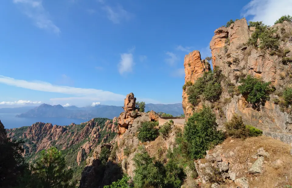
Carved into the rugged western coastline of Corsica inside the Corse-du-Sud department, the Gulf of Porto is a deep indentation of the Mediterranean Sea measuring roughly 7 miles in length and 5 miles in width between Ajaccio and Calvi. Encompassed within the Regional Natural Park of Corsica and inscribed on the UNESCO World Heritage Atlas in 1983 under natural criteria (vii), (viii), and (x), the site brings together three distinct yet geologically unified coastal landscapes: the Calanques de Piana (known in Corsican as calanchi di Piana or calanche di Piana) on the southern shore, the sheltered inlet of the Gulf of Girolata, and the volcanic headland of the Scandola Nature Reserve on the Scandola peninsula to the north. In his 1891 French travel account Une excursion en Corse, Prince Roland Bonaparte celebrated this coastline as one of the finest natural landscapes in Corsica, while UNESCO characterises the formation as an impressive porphyry massif sculpted into tormented shapes.
Proceeding clockwise from the northern headland around the head of the bay to the southern promontories, five coastal communes border the waters of the Gulf of Porto: Osani and Partinello together with Serriera as well as Ota and Piana. At the eastern head of the gulf in the commune of Ota, the mountain waters of the Porto River empty into the sea beneath steep granite and porphyry slopes. Across the entire perimeter of the bay, orange-red porphyry and red ochre cliffs rise directly from the surf to heights of up to 900 metres. Centuries of wind and salt spray combined with wave action have hollowed the sheer rock faces into deep marine grottoes alongside inaccessible caves; offshore sea stacks and rocky islets shelter hidden coves from the incoming swell.
Above the splash zone, the porphyritic rock mass of the Scandola peninsula and the crags of Piana support an exceptional example of Mediterranean maquis shrubland. Adapted to summer drought and steep gradients as well as salt-laden winds, this evergreen scrubland blankets the ledges and ravines between the red ochre pinnacles while stabilising thin volcanic soils and framing views across the deep blue gulf. Geographical compendia such as editors Richard L. Scheffel and Susan J. Wernet in their 1980 natural heritage compendium (published by the Reader's Digest Association, page 303) highlight how the 7-mile-long and 5-mile-wide bay unites volcanic geology with Mediterranean coastal ecology. Across the northern arm of the site, the Scandola peninsula juts into the sea as a roadless porphyritic headland accessible only by foot or boat, separated from the mainland road network by the sheltered anchorage of the Gulf of Girolata. Along the southern shore between Ota and Piana, the road weaves directly through the weathered red ochre pinnacles and ravines of the Calanques de Piana, offering elevated vantages down to the surf and across the bay toward the northern cliffs of Osani and Partinello.
Submerged Algal Forests and Cliff-Nesting Seabirds
Beneath the clear waters of the Gulf of Porto and its surrounding islets, strong coastal currents together with unpolluted sunlit rock walls sustain rich marine biodiversity. Along the littoral splash zone, sea lavender dominates the rocky ledges; below the surface, submerged reefs and underwater cliffs harbour all 450 species of marine algae known to exist in the entire Mediterranean Sea. These underwater forests include rare Halimeda species and other algal communities not observed anywhere else along the coasts of France. Because the water clarity across the gulf is exceptionally high, photosynthetic marine algae grow to depths of 35 metres down the vertical cliff faces.
In the shallower rocky crevices and shaded overhangs of the gulf grows precious coral, while the strong currents sweeping past the headlands bring nutrients that cause large shoals of coastal and pelagic fish to congregate around the islets and submerged pinnacles. Above the water, the inaccessible porphyry ledges of the Scandola Nature Reserve and the Calanques de Piana provide undisturbed breeding sites for cliff-nesting marine birds such as seagulls and cormorants alongside sea eagles that hunt across the open waters of the gulf.
Leca Lords and the Genoese Coastal Watchtowers
Throughout the medieval and early modern eras, the Porto-Piana coastline remained sparsely populated because of its precipitous terrain and turbulent political past. As the Middle Ages drew to a close, the valleys, and the headlands around the gulf fell under the feudal lordship of the Leca family, one of the powerful Cinarchesi noble houses of Corsica, until Count Giovan Paolo di Leca drew the western valleys into armed conflict at the close of the 15th century. Across the decades between the mid-15th century and the late 16th century, recurring waves of plague swept the coastal settlements, followed from the 16th to the 18th centuries by severe food shortages and famines that decimated the local population.
Compounding these demographic crises were relentless amphibious raids by Barbary corsairs across the latter half of the 16th century. Corsair attacks wiped out entire coastal villages such as Paomia and Revinda, leaving the low-lying agricultural lands deserted; historical chronicles from 1584 record that the district of Sia alongside the pit of Salogna and the settlement of Paomia stood completely ruined and abandoned. To defend the shoreline and warn inland mountain villages of approaching raiding fleets, Genoan authorities erected a network of stone watchtowers known as the Genoese towers in Corsica. Three historic towers guard the immediate shore of the Gulf of Porto: the island watchtower of Torra di l'Isula di Gargali atop the offshore islet of Gargalo near Osani on the west coast, the Torra di Portu at the mouth of the Porto River in Ota at the head of the gulf, and the Torra di Turghju crowning the high southern headland in Piana.
When it became evident at the start of the 17th century that the existing defences could not hold back the corsairs, residents of the inland mountain communities who farmed coastal lands petitioned for additional fortifications. During the years 1605 to 1611, supervised by the architect Anton Giovanni Sarola, masons rebuilt the watchtower at Sagone and erected six new coastal towers at Omigna and Cargèse alongside Orchinu and Cavi Rossi as well as Imbuto and Gargalo. During this same era, Genoan authorities instituted a policy of land concessions that established a Greek colony at Cargèse, sparking long-running tensions with surrounding Corsican villagers. Even after the corsair threat subsided in the 18th and 19th centuries, the sheer 900-metre relief between the mountain ridges and the sea prevented industrial development along the shoreline. Consequently, the historic Genoese watchtowers at Gargalo, Ota, and Piana still look out over an unspoilt coastal panorama where maquis scrubland, sea-lavender ledges, and submerged coral and Halimeda beds remain much as they were when Prince Roland Bonaparte surveyed the bay in 1891.
Field Planning Around Piana, Ota, and the Scandola Peninsula
Today, the red ochre cliffs and Genoese watchtowers of the Gulf of Porto rank among the most striking coastal landmarks in the Mediterranean. Sea winds buffet the high headlands. Protecting both the fragile maquis scrubland on land and the 450 algal species and coral beds underwater requires careful visitor discipline across all five communes.
- Entry and Route Along the Gulf: Travellers arriving in Corsica by ferry or flight from Nice via Ajaccio or Calvi can follow the coastal road linking Piana and Ota with Serriera, Partinello, and Osani. Walk the marked trails through the red ochre pinnacles of the Calanques de Piana and climb out to the Torra di Turghju or descend to the mouth of the Porto River at the Torra di Portu in Ota.
- Boat Excursions and Coastal Viewpoints: Because the Scandola Nature Reserve on the Scandola peninsula and the offshore islet of Gargalo (with its Torra di l'Isula di Gargali) protect sensitive seabird cliffs and marine habitats, check the official site of provincial park authorities for seasonal boat excursion rules and trail access updates before setting out.
- Timing and Onward Connections: Stay strictly on marked footpaths to prevent erosion of the steep porphyry slopes, pack windproof layers suited to rapid coastal elevation changes up to 900 metres, and schedule walks for early morning or late afternoon when low sunlight ignites the orange-red cliffs. Pair your Corsican journey with our city guide to Nice and explore our UNESCO World Heritage Atlas for more Mediterranean heritage sites.
