


























Quick Field Data
- UNESCO Inscription: 1999, modified in 2017 (Mixed Cultural and Natural, Criteria iii, vi, vii, x; Property ID 911bis).
- Scale & Footprint: 99,975 to 107,044-hectare property (with a 27,888 to 40,170 ha buffer zone) comprising four protected areas: Wuyishan National Nature Reserve (56,527 ha, west), the central Nine-Bend Stream Ecological Protection Area (covering 36,400 ha), Wuyishan National Scenic Area (7,000 ha, east), and the Ancient Han Dynasty Remains at Chengcun (48 ha, 15 km southeast).
- Access & Ticketing: Controlled ecological reserve and scenic park between Wuyishan City (Nanping Prefecture, Fujian) and Wuyishan in Shangrao (Jiangxi); check the official site for bamboo raft bookings on the Nine-Bend River and entry to the scenic gorges and Chengcun Han ruins.
- Arrival Logistics: Located at 27.6404°N, 117.8842°E across northern Fujian and northeastern Jiangxi provinces in southeastern China, rising between 200 m (656 ft) along the river valleys and 2,158 m (7,080 ft) at Mount Huanggang.
Cathaysian Fault Peaks, Danxia Cliffs, and the Sixty-Kilometre Nine-Bend River
Positioned at 27.6404 degrees north and 117.8842 degrees east along the border between Nanping Prefecture in northwestern Fujian province and Shangrao City in northeastern Jiangxi province in southeastern China, Mount Wuyi (the Wuyi Mountains or Wuyishan, written 武夷山 in Chinese, Wǔyí Shān in pinyin, and known in early Western documents as the Bohea Hills from Hokkien Bú-î-soaⁿ) spans a total protected area of 99,975 hectares (surrounded by a 27,888-hectare buffer zone, and extended in 2017 under ID 911bis to 107,044 hectares with a 40,170-hectare buffer zone). Inscribed in 1999 as a mixed cultural and natural World Heritage site under Criteria iii, vi, vii, and x, the site unites three contiguous ecological zones with an outlying archaeological zone located 15 kilometres to the southeast: the Wuyishan National Nature Reserve in the west (56,527 hectares, portions of which also form the Fujian and Jiangxi Wuyishan Biosphere Reserves), the central Nine-Bend Stream Ecological Protection Area spanning 36,400 hectares, the Wuyishan National Scenic Area in the east (7,000 hectares), and the 48-hectare Chengcun Protection Area conserving the Remains of the Ancient Han Dynasty.
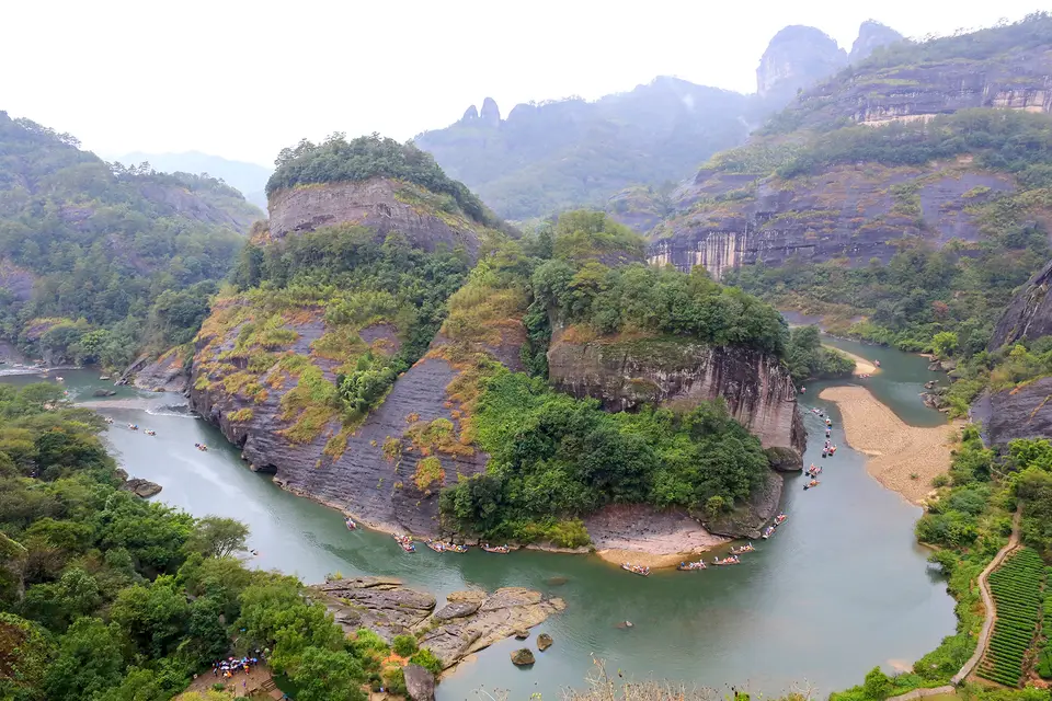
Formed within the Cathaysian fold system through ancient volcanic activity, fault-block uplift, and subsequent water erosion and weathering, the mountain range displays a sharp geological contrast between west and east. In the western sector, volcanic and plutonic bedrock of tuff, rhyolite, and granite rises to the range's highest summit, Mount Huanggang, which rises to 2,158 m (or 7,080 ft) along the provincial border separating Fujian and Jiangxi (the highest point in both provinces). In the eastern sector around the scenic area (where lowest elevations drop to roughly 200 metres or 656 ft), red sandstone formations eroded into the sheer-sloped, flat-topped monoliths, dome-shaped cliffs, and narrow fissures of the Danxia landform, including Jade Girl Peak, Roaring Tiger Rock (where wind funnelled into a cavern produces a tiger-like roar), Ling Cave, Feng Cave, and Fuxi Cave, whose narrowest ceiling fissure, the Thread of Sky, measures less than 40 centimetres (16 in) wide. Winding for about 60 kilometres through a deep gorge among these red sandstone cliffs is the Jiuqu Xi (Nine-Bend River or Nine-Bend Stream), a shallow stream navigable by small rowboats and bamboo rafts that narrows at one constriction to just a few metres across while plunging to a water depth of 80 metres (260 ft).
Because the high western ridge blocks cold air masses advancing from the northwest while trapping warm, moisture-laden maritime air from the sea, Mount Wuyi maintains a humid subtropical climate (with relative humidity of 80 to 85%, mean annual temperatures of 12 °C to 18 °C or 64 °F at lower elevations, and snowy winters on the highest peaks) and heavy annual precipitation averaging 2,200 millimetres (220 cm or 86.6 in) in the southwest and 3,200 millimetres in the north, monitored since 31 January 2005 by China's first regional air-quality station.
Pre-Glacial Subtropical Forests and Five Thousand Animal Species
Having escaped continental glaciation for roughly 3 million years since prior to the Ice Age, and studied by field biologists since 1873, Mount Wuyi preserves the largest and most intact representative tract of Chinese Subtropical Forest and South Chinese Rainforest. Across the 200-to-2,158-metre elevation gradient, botanists classify 11 distinct vegetation zones: warm coniferous woodland, temperate coniferous forest, mixed temperate broad-leaved and coniferous stands, deciduous broad-leaved woodland, mixed evergreen and deciduous broad-leaved forest, evergreen broad-leaved woodland, bamboo groves, deciduous broad-leaved scrub, evergreen broad-leaved shrubland, brush-wood, and high-altitude meadow steppe. Surveys have recorded 2,888 species of higher plants belonging to 1,107 genera and 284 families alongside 840 species of lower plants and fungi, dominated by evergreen broad-leaved trees from the witch-hazel (Hamamelidaceae), Elaeocarpaceae, magnolia (Magnoliaceae), camellia (Theaceae), laurel (Lauraceae), and beech (Fagaceae) families.
This relict forest refugium shelters approximately 5,000 reported animal species, comprising 475 vertebrate species and 4,635 insect species. Forty-nine of these vertebrates are endemic to China, while three species are strictly endemic to Mount Wuyi: the bird David's parrotbill (Neosuthora davidiana), the colubrid bamboo snake Pseudoxenodon karlschmidti, and the amphibian Pope's spiny toad (Vibrissaphora liui). Threatened and endangered fauna inhabiting the reserve include the golden Kaiser-i-Hind swallowtail butterfly (Teinopalpus aureus), the Chinese giant salamander (Andrias davidianus), the Chinese black-backed pheasant (Syrmaticus ellioti), Cabot's tragopan (Tragopan caboti), the mainland serow (Capricornis milneedwardsii), the hairy-fronted muntjac (Muntiacus crinifrons), the clouded leopard (Neofelis nebulosa), and the South China tiger (Panthera tigris amoyensis).
Shang Boat Coffins, the Chengcun Han Capital, Neo-Confucianism, and Wuyi Rock Tea
Human activity on the slopes of Mount Wuyi extends back 4,000 years. Suspended high inside sheer cliff crevices above the river gorges are wooden boat coffins dating to the Shang Dynasty (2nd millennium BCE), the oldest suspended boat-coffin burials known. Fifteen kilometres southeast of the mountain gorges at Chengcun stands the 48-hectare archaeological site of the massive walled administrative capital of the Minyue Kingdom, established by Western Han Dynasty rulers in the 1st century BCE. By the 7th century CE, emperors constructed the Wuyi Palace at the foot of the hills for imperial sacrificial ceremonies, and across the centuries more than 60 Taoist temples and monasteries were built along the riverbanks and peaks, with authentic architectural remains surviving at the Taoyuan Temple, Wannian Palace, Sanqing Hall, Baiyun Temple, Tianxin Temple, and the 1707 Tiancheng (Tian Cheng) Temple with its cliff-carved relief statue of the goddess of mercy. Since the 11th century CE, the serene gorges of the Nine-Bend River became the cradle of Neo-Confucianism, an influential East Asian political and ethical philosophy; archaeologists have located the remains of no fewer than 35 ancient Confucian academies built between the Northern Song and Qing Dynasties (10th to 19th centuries CE).
The mineral-rich Danxia cliffs are equally celebrated as the birthplace of oolong and black Wuyi rock-essence teas, headed by the four famous cultivars known as Si Da Ming Cong: Da Hong Pao (translated as "Big Red Robe"), Shui Jin Gui ("Golden Water Turtle"), Bai Jiguan ("White Cockscomb"), and Tie Luo Han ("Iron Arhat"), alongside Lapsang souchong. Living intangible traditions include the Jingzhe Day "Mountain Call" and "Mountain Open" rituals in the imperial tea garden (where planters chant "tea, tea, sprout"), comedic tea-picking opera rooted in Hakka culture, leap-year Liu Qin family reunion meals, and the 70-minute open-air Impression Da Hong Pao landscape theatre performance. Since 1999, the UNESCO World Heritage Atlas in 1999 (after annual visitor numbers grew between 424,000 in 1993 and 700,000 in 1998), Mount Wuyi can be pinpointed on our interactive world map. Bamboo rafts glide beneath the red cliffs.
- Rafting the Nine-Bend River past Shang boat coffins and Jade Girl Peak: Board a traditional bamboo raft along the 60-kilometre Jiuqu Xi gorge to float past the 80-metre-deep river constriction, viewing the suspended Shang Dynasty wooden boat coffins in the high rock shelters, Jade Girl Peak, the 7th-century Wuyi Palace, Wannian Palace, and the sites of the 35 Northern Song to Qing Neo-Confucian academies.
- Hiking Fuxi Cave, Roaring Tiger Rock, and the 1707 Tiancheng Temple: Follow the stone mountain paths of the 7,000-hectare Wuyishan National Scenic Area through the less-than-40-centimetre Thread of Sky fissure inside Fuxi Cave, visit Ling Cave, Feng Cave, and Roaring Tiger Rock, and inspect the cliff-carved goddess of mercy relief at Tiancheng Temple alongside historic Da Hong Pao tea terraces.
- Exploring the 1st-century BCE Western Han capital at Chengcun: Travel 15 kilometres southeast of the main scenic gorges to the 48-hectare archaeological protection zone at Chengcun to examine the massive rammed-earth city walls and palace foundations of the Western Han Dynasty and Minyue Kingdom administrative capital.
