


























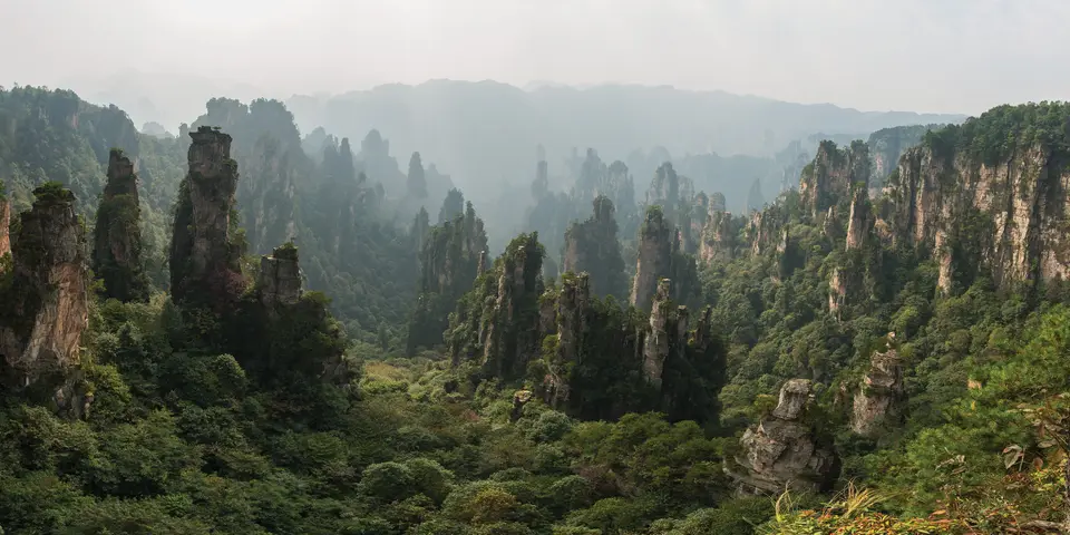
Quick Field Data
- UNESCO Inscription: 1992 (Natural heritage property in the Wulingyuan District of Zhangjiajie City, northwestern Hunan Province, China)
- Scale & Footprint: 26,400 hectares of World Heritage core area spanning 26,000 to 26,400 hectares across Zhangjiajie National Forest Park, the Suoxi Valley Nature Reserve, the Tianzi Mountain Nature Reserve, and the Yangjiajie scenic sector
- Access & Ticketing: Administered by the Wulingyuan District People's Government and Zhangjiajie National Park Authority; check the official site for multi-day biometric park passes, eco-shuttle routes, and cableway or Bailong Elevator tickets
- Arrival Logistics: Located roughly north of downtown Zhangjiajie City, and 270 kilometres northwest of the provincial capital of Changsha
Devonian Quartz-Sandstone Pillars and Tectonic Uplift
Rising out of the subtropical ravines of the Wuling Mountain range in northwestern Hunan Province, the Wulingyuan Scenic and Historic Interest Area encompasses 26,400 hectares of towering stone spires, knife-edge ridges, and deep karst caves spanning 26,000 to 26,400 hectares. For China, the UNESCO World Heritage Atlas in 1992 and celebrated for its sandstone peak forest, the reserve lies inside the Wulingyuan District of Zhangjiajie City, some 270 kilometres northwest of Changsha, and brings together four contiguous conservation sectors: Zhangjiajie National Forest Park, established in the late twentieth century as China's very first national forest park, alongside the Suoxi Valley Nature Reserve, the Tianzi Mountain Nature Reserve, and the recently developed cliffs of Yangjiajie.
The signature geological spectacle of Wulingyuan consists of more than 3,000 narrow, vertical quartz-sandstone pillars and peaks, many of which soar higher than 200 metres, with the tallest monoliths approaching 400 metres from base to crest within a terrain climbing to over 1,050 and 1,070 metres above sea level. Unlike the rounded limestone tower karsts of South China that form primarily through chemical dissolution, the "Zhangjiajie landform" developed inside a thick thick bed of Devonian marine quartz sandstone deposited hundreds of millions of years ago along an ancient continental shoreline, composed of hard hard quartz grains bound by siliceous and iron cement.
As the Himalayan orogeny uplifted western Hunan during the Cenozoic and Quaternary periods, tectonic stress fractured the rigid horizontal sandstone platform along orthogonal networks of vertical joints and faults. Heavy subtropical monsoonal rainfall, running streams, root wedging, frost action, and gravity collapse eroded down through these intersecting vertical cracks, stripping away the softer underlying shale beds and carving the plateau into isolated, flat-topped stone columns, pinnacle walls, and residual mesas whose horizontal bedding planes remain clearly visible along their sheer vertical faces. Alongside the quartz-sandstone forest, underlying and adjacent Carboniferous and Permian limestone strata have been hollowed out by subterranean streams into more than 40 immense karst caverns, most famously the four-storey labyrinth of the great karst caverns of Suoxi Valley with underground waterfalls and massive stalagmites, as well as two colossal natural rock bridges: the natural stone bridge of Tianqiaoshengkong, spanning a chasm 357 metres above the valley floor. Mist coils around the stone pillars. Across the 26,400-hectare World Heritage site in Wulingyuan District of Zhangjiajie City, located 270 kilometres northwest of Changsha in Hunan Province, the four linked scenic areas of Zhangjiajie National Forest Park, the Suoxi Valley Nature Reserve, the Tianzi Mountain Nature Reserve, and the Yangjiajie scenic sector preserve more than 3,000 freestanding sandstone peaks, 40 caves, and two natural bridges cut by streams and tectonic uplift across the Wuling Mountain Range.
Subtropical Tertiary Relict Forests and Montane Biodiversity
Because the rugged vertical topography of the Wuling Mountains shielded deep gorges from Quaternary continental ice sheets and prevented large-scale agricultural clearing, Wulingyuan preserves dense subtropical forest cover and functions as a botanical ark for ancient Tertiary relict plants. Surveys across the four scenic sub-areas have recorded some 3,000 vascular plant species, including hundreds of species of woody trees and shrubs. Clinging directly to fractured quartz ledges and crowning the flat summits of needle-like pillars are twisted pines, while the humid canyon floors below shelter stands of dove trees, maidenhair trees, dawn redwoods, tulip trees, and ancient magnolias, camellias, and taxus yews.
Beneath the dense evergreen and deciduous broad-leaved canopy, five mountain streams in the Suoxi Valley watershed wind through pebble beds and shaded pools. These crystal-clear torrents provide critical breeding habitat for the critically endangered Chinese giant salamander, the world's largest amphibian and is known locally as the "baby fish" for its vocalizations.
Across the forested cliffs, caves, and ravines live numerous terrestrial vertebrates, including bands of macaques that scale the vertical sandstone columns, alongside the Asiatic black bear, clouded leopard, leopard, Asiatic dhole, serow, Chinese water deer, Chinese pangolin, and musk deer. Avian life is equally conspicuous among the misty peaks, highlighted by the vivid golden pheasant, mountain pheasants, koklass pheasant, tragopans, and white-crowned forktails along the mountain streams, while historic local mountain ethnic minority communities inhabiting the surrounding valleys maintain traditional stilt-house architecture and terraced hill farming. Geologists and conservationists studying the Devonian quartz-sandstone strata of Wulingyuan note that the vertical joint planes, combined with heavy seasonal rainfall and deeply incised stream valleys between 350 and 1,070 metres in elevation, have produced an array of stone pillars, walls, gorges, and mesa plateaux that remains distinct from carbonate karst landscapes elsewhere in China. When morning clouds rise from the humid ravines of Suoxi Valley after rain, the lower bases of the 200 to 400 metre columns vanish into white vapour, leaving the pine-crested summits appearing to float like rocky islands across the skyline. Because the Wulingyuan Scenic and Historic Interest Area lies within a humid subtropical monsoon climate zone in northwestern Hunan Province, abundant annual precipitation feeds the mountain streams, waterfalls, and underground karst rivers that continue to incise the gorges today. Conservation planning across the 26,400-hectare World Heritage site balances ecological protection of the subtropical broad-leaved and coniferous forests with visitor management along the shuttle corridors, cableways, stone footpaths, and the 326-metre Bailong Elevator, ensuring that the habitats of Asiatic black bears, clouded leopards, Chinese giant salamanders, and Chinese water deer remain buffered within the deep ravines of the Wuling Mountain Range. Whether walking through the quiet stream valleys at 350 metres or standing on the forested sandstone overlooks above 1,050 metres, visitors encounter one of China's most dramatic geological and botanical reserves.
Walking the Forest Park Canyons and Ascending Huang Shi Zhai and Tianzi Mountain
Navigating Wulingyuan requires understanding its two vertical tiers: the cool, shaded canyon bottoms accessible from the Southern Gate at Zhangjiajie National Forest Park or the Eastern Gate at Wulingyuan District, and the high plateau rim above 1,050 metres connecting Huang Shi Zhai, Yangjiajie, and Tianzi Mountain. A unified park shuttle network links the upper viewpoints and lower trailheads, supported by three aerial cableways at Huang Shi Zhai, Tianzi Mountain, and Yangjiajie, as well as the Bailong Elevator, a 326-metre double-deck glass cliffside lift built into the vertical sandstone face.
- Forest Park canyon walk and Huang Shi Zhai mesa loop: Enter through the Southern Forest Park Gate to walk the level flagstone footpath along the main canyon stream, where clear mountain water flows beneath a 350 to 400 metre quartz-sandstone monolith and past wild macaques and dove trees. Before or after the canyon walk, ride the cableway or climb the 3,450 stone steps to the flat summit plateau of Huang Shi Zhai at 1,050 metres, where a circular rim trail offers panoramic views into a sea of freestanding sandstone needles.
- Bailong Elevator ascent, sandstone monoliths, and Tianqiaoshengkong natural bridge: From the canyon floor, ascend to the upper sandstone plateau via the 326-metre Bailong Elevator or the hiking steps through亂竄坡 (the steep stone trail). Follow the cliff-edge promenade past the panoramic viewpoint to the freestanding quartz-sandstone monoliths rising 200 to 350 metres above the ravines, and continue to the natural stone arch of Tianqiaoshengkong, spanning the abyss 357 metres above the valley floor.
- Tianzi Mountain, Yangjiajie rock walls, and the subterranean karst caverns: Board the upper park shuttle bus across the ridge through Yangjiajie, where parallel vertical sandstone curtains stand like ancient defensive ramparts along the terraced ridges, to reach the high lookouts of Tianzi Mountain overlooking rows of needle-like stone spires. Descend via the Tianzi Mountain cableway toward the Suoxi Valley Nature Reserve to explore the high-gorge lakes, waterfalls, and 40 subterranean karst caves hollowed into the limestone beds, where underground rivers, stalactites, and stalagmites illustrate the geological contrast between the soluble carbonate caverns below and the insoluble Devonian quartz-sandstone pillars towering overhead. By combining valley-floor stream walks inside Zhangjiajie National Forest Park with upper-rim circuits across Huang Shi Zhai, Tianzi Mountain, and Yangjiajie, travellers can observe the full vertical profile of the Devonian sandstone formations from their shaded stream bases up to their forested plateau caps.
