Quick Field Data
- UNESCO Inscription: Ref. 1432 · Natural Site · Inscribed 2014 (thousandth World Heritage Site) · Criteria (vii), (ix), (x)
- Scale & Footprint: 2,023,590 hectares (including roughly 600,000 hectares of permanent swamp and up to 1.2 million hectares of seasonally flooded plains), bordered by a 2,286,630-hectare buffer zone
- Access & Ticketing: Communal Tribal Land overseen by the Tawana Land Board across Moremi Game Reserve (roughly 40 percent of core area) and 18 Wildlife Management Areas; park entry fees and concession permits apply, so check official Botswana tourism and wildlife portals before travelling
- Arrival Logistics: 95 kilometres northwest of Maun International Airport (MUB), Botswana's main safari aviation hub for light-aircraft transfers into interior delta camps
Dry-Season Flood Pulses Across a Rift-Captured Alluvial Fan
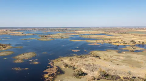
Inscribed on 22 June 2014 as the thousandth site in the UNESCO World Heritage catalogue, the Okavango Delta earned African natural status in Arusha on 11 February 2013. It spreads across a sunken tectonic trough at 930 to 1,000 metres elevation within the Kalahari Desert of northwestern Botswana. Remnant shoreline scars confirm the basin once formed part of ancient Lake Makgadikgadi before drying up by the early Holocene. Named after the Okavango River (derived from Kavango for the Kavango people of northern Namibia), historian Andreas Eckl notes older colonial German maps added an initial O- under Herero influence. Fault movement tied to the southwestern extension of the African Rift Valley captures the long Angolan-Namibian river formed where Angola's Cubango and Cuito rivers unite before crossing Namibia's Caprivi Strip. Its waters fan across Africa's third largest alluvial fan and largest endorheic inland delta with zero outlet to the sea.
What transforms Okavango hydrology into a global biological clock is its inverted flood timing. Local delta rainfall averages only 450 millimetres annually, roughly a third of precipitation falling over its Angolan headwaters. Rain arrives mostly as sharp afternoon thunderstorms between December and March when daytime heat nears 40 degrees Celsius and humidity swings between 50 and 80 percent. From March to May, daytime maxima ease toward 30 degrees Celsius with mild to cool nights. Meanwhile, January and February summer rains soaking central Angolan highlands send a massive surge down the Okavango River for 1,200 kilometres over roughly one month. Entering Botswana near Mohembo, floodwaters spread gradually across the delta's 6,000 to 15,000 square kilometres (and up to 37,500 square kilometres across the wider watershed) from March through June.
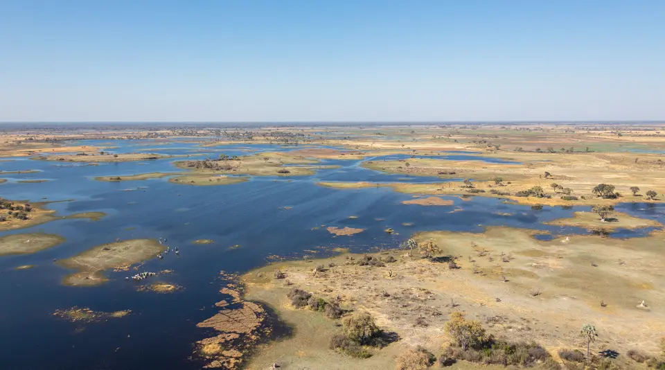
By June, July, and August, local rains vanish and Botswana enters its cool, dry winter, bringing mild days and cold nights barely above freezing with occasional frost. Floodwaters hit peak volume then, expanding the wetland to three times its permanent dry-season size. Across an extraordinarily flat alluvial fan where terrain varies less than 2 metres across 15,000 square kilometres, water drops only 60 metres between Mohembo and Maun. Roughly 11 cubic kilometres of inflow disperse through branching distributary channels including the Boro, Maunachira, Thaoge, Santantadibe, Nqoga, and Jao systems. Roughly 96 to 98 percent of incoming water evaporates back into Kalahari air or transpires through swamp plants and shallow alluvial aquifers. Only a tiny fraction exits via the Thamalakane and Boteti rivers toward Lake Ngami before hot September-to-November weather builds up and October daytime highs surge past 40 degrees Celsius again.
Termite-Mound Islands, Papyrus Glue, and Subsurface Salt Rings
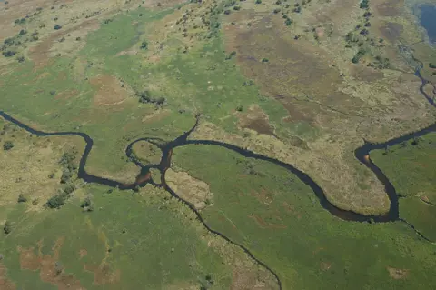
Clean water physics dictate how islands rise across the delta. Unlike muddy tropical rivers that build silt levees mechanically, waters flowing off sandy Angolan and Kalahari catchments carry virtually pure sand and almost zero clay mud. Aquatic vegetation bridges that structural gap: five dominant plant communities lock loose sand grains together like living glue. Dense beds of Papyrus cyperus anchor deep slow-moving channels, Miscanthus dominates shallow seasonal floodplains, and Phragmites australis, Typha capensis, and Pycreus fill intermediate depths, trapping sand loads to raise new banks where trees take hold.
Roughly 70 percent of the delta's thousands of small wooded islands begin around mounds built by Macrotermes termites rising slightly above flood height. Once wild palms (Hyphaene petersiana), acacias, and rain trees (Philenoptera violacea) take root on those elevated mounds, intense root transpiration draws groundwater upward while leaving dissolved minerals behind. Subsurface precipitation of calcite and amorphous silica expands soil volume below ground and concentrates sodium salts toward island cores. Over decades, island rims stay sandy enough for lush green tree belts while inner cores turn sterile, salt-crusted white patches bare except for solitary salt-tolerant palm trees.
Larger tectonic structures add higher refuge ground when winter waters peak. Uplifted along a geological fault line, Chief's Island stretches over 70 kilometres long and 15 kilometres wide across the central delta. Formerly reserved as exclusive royal hunting grounds, Chief's Island now anchors wildlife protection inside Moremi Game Reserve on the eastern side of the delta, concentrating terrestrial grazing herds onto dry corridors surrounded by rising floodwaters.
Wetland Megafauna, OKACOM Treaties, and Veterinary Fences
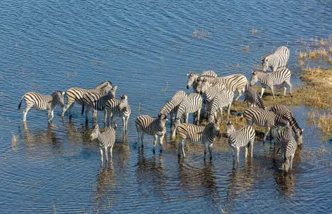
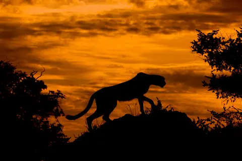
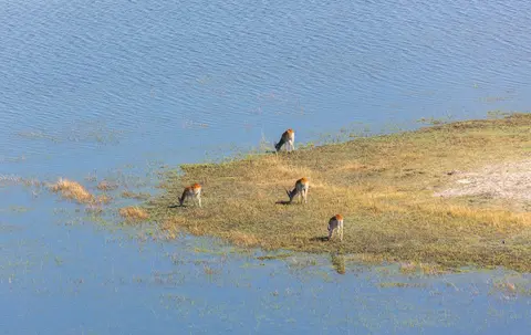
Over 1,061 to 1,068 plant species (representing 134 families and 530 genera) support dense mammal, bird, reptile, and fish communities synchronised precisely to winter flood arrival. Researchers record 130 mammal species, 64 reptiles, and 71 to 89 fish species (including predatory tigerfish, tilapia, 1.4-metre African sharptooth catfish, and tiny 3.2-centimetre sickle barbs shared historically with the Zambezi River). The delta's most abundant large mammal is the semi-aquatic red lechwe, numbering roughly 88,000 individuals. Sitatunga, hippopotamus, Nile crocodile, African buffalo, giraffe, plains zebra, blue wildebeest, impala, common eland, greater kudu, sable antelope, roan antelope, puku, waterbuck, tsessebe, and warthog also share the floodplains. Smaller mammals include honey badger, aardvark, aardwolf, bat-eared fox, African savanna hare, caracal, serval, chacma baboon, and vervet monkey. Predators include black-backed jackals, African wild dogs, spotted hyenas, leopards, cheetahs, and lions (protected since 2005 inside a shared Lion Conservation Unit linked with Hwange National Park). Botswana hosts the world's largest African elephant population at around 130,000 individuals, with the Okavango serving as a primary survival stronghold. By contrast, black and white rhinoceroses suffered heavily when poachers killed 92 out of roughly 150 northern delta rhinos in 2020 to 2021, forcing authorities to relocate the remaining 40 individuals.
Avian richness earns the basin BirdLife International Important Bird Area status across 400 to 482 recorded species, including 24 globally threatened birds and thirty-three waterbird populations exceeding 0.5 percent of global or regional numbers. Key species range from wattled cranes, slaty egrets, crested cranes, and Pel's fishing owls to southern ground-hornbills, African skimmers, African fish eagles, African darters, African spoonbills, marabou storks, Egyptian geese, South African shelducks, helmeted guineafowl, lilac-breasted rollers, secretary birds, common ostriches, and six vulture species.
Human history and transboundary treaties govern whether this system stays intact. Five distinct ethnic peoples live across the delta margins using diverse languages and subsistence methods. The Hambukushu (including over 4,000 refugees resettled around Etsha in the western Panhandle during the late 1960s and early 1970s), Dceriku, and Wayeyi (around Seronga and Maun) combine millet and sorghum farming with fishing and stock-raising. Bugakhwe and River Bushmen (||anikhwe) historically specialised in forest and riverine gathering and fishing along the panhandle, Boro, and Boteti channels. Politically controlled by the Batawana since the late 18th century and solidified under Chief Mathiba in the 1850s ivory trade, cattle herders settled delta edges due to sleeping-sickness tsetse flies. Herders moved inside swamps briefly only during a 40-year tsetse retreat from 1896 to the late 1930s. Today, permanent protection balances Tribal Land tenure under the Tawana Land Board (1968 Tribal Land Act), Botswana's 1992 Wildlife Conservation and National Parks Act, and a national hunting ban. Upstream diplomatic cooperation runs through the Permanent Okavango River Basin Water Commission (OKACOM), uniting Angola, Namibia, and Botswana to keep the river free of dams and industrial abstraction. Remaining threats involve mining exploration outside park boundaries, poaching pressures (including giraffe meat poaching), and uncoordinated wildlife surveys that leave fluctuating population trends poorly understood. Veterinary cordon fencing adds challenges, with the Southern Buffalo Fence marking the southern boundary against cattle grazing and the Northern Buffalo Fence disrupting Roan and Sable antelope dispersal. Authorities work to establish an integrated monitoring programme across the Department of Wildlife and National Parks, rationalise unnecessary cordon fences, and remove invasive alien species. They also ensure indigenous communities around the fringes share tourism benefits from Maun's modern safari sector, which has expanded steadily since the late 1960s via small temporary tented camps and low-impact bush tracks. Inside the wider reserve patchwork, roughly 40 percent of the core UNESCO area sits inside Moremi Game Reserve. The remaining terrain divides into 18 Wildlife Management Areas and a Controlled Hunting Area run through community trusts or private tourism concessions where traditional low-impact subsistence fishing and gathering remain respected. Travellers planning multi-day boat or 4WD itineraries out of Maun should allow time for seasonal water shifts along the Thaoge, Nqoga, and Jao distributaries. Channel blockages and shifting sand bars alter mokoro routes from one flood winter to the next.
Access Across Moremi Game Reserve and Concession Sectors
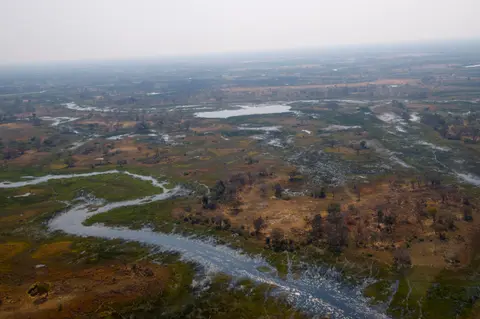
Because inner swamp zones forbid roads and permanent concrete resorts, visitors reach interior lagoons either by light aircraft from Maun into small temporary tented camps or via self-drive 4WD tracks along eastern Moremi Game Reserve.
| Complex Zone | Key Highlights | Access & Ticket Rule |
|---|---|---|
| Moremi Game Reserve & Chief's Island | Eastern core representing 40 percent of the UNESCO boundary, 70-kilometre Chief's Island uplift, lions, wild dogs, and lechwe | Accessed by rugged 4WD tracks from Maun or light bush flights; national park gate entry fees and campsite reservations apply |
| 18 Wildlife Management Areas (Interior WMAs) | Private and community-trust wetland concessions navigated by dug-out mokoro canoes and boat channels | Access runs strictly through licensed fly-in tented camps and community trusts under strict environmental limits |
| Mohembo Panhandle & Etsha Corridor | Deep northern entry channel where the Okavango enters Botswana, tigerfish channels, and riverside villages | Reached overland along western paved highways north from Maun toward Shakawe; boat hire available from riverside lodges |
| Maun Gateway & Boro Outflow Edge | Southern delta outflow toward Lake Ngami, Maun International Airport (MUB), and Southern Buffalo Fence border | Main commercial town for safari provisioning, scenic flights, and community-run mekoro day excursions along the Boro |
Three Ecological Mechanics Visible From Water and Air
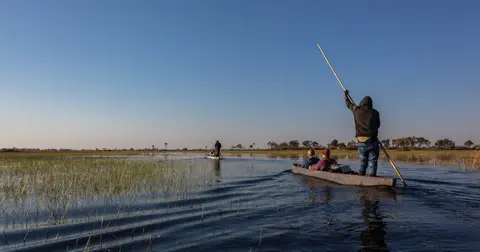
Whether gliding in a pole-driven wooden mokoro canoe or looking out from a small bush plane between Maun and Chief's Island, three field details reveal how the delta sustains itself.
- White Salt Halos Inside Tree-Ringed Islands: Look at circular islands from the air to see lush green jackalberry, palm, and rain trees ringing chalky white barren sand cores. Root transpiration draws up pure water while locking toxic calcite and silica salts dead centre, forcing new seeds onto outer rims.
- Papyrus Wall Channels Filtering Crystal Water: Gliding silently by mokoro along the Boro or Maunachira channels reveals thick walls of Papyrus cyperus straining suspended sand from the current, leaving submerged aquatic grasses visible across crystal-clear water.
- Termite-Mound Anchors Rising Above Flooded Grass: Across inundated seasonal plains, small elevated tree clumps mark abandoned Macrotermes termite mounds standing inches above winter floodwater, proving how insects jump-start roughly 70 percent of new Okavango islands.
Plan delta safaris between June and August for peak dry-season floods and dense mammal congregations around dry islands, or March through May for milder 30-degree Celsius autumn days as waters begin rising from Angola. Connect northwestern Botswana's inland wetlands with national urban gateways via our Gaborone travel guide or browse more African ecosystems inside the UNESCO World Heritage Atlas.