


























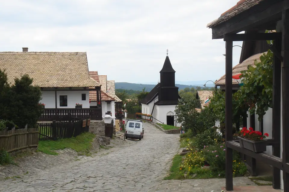
Quick Field Data
- UNESCO Inscription: 1987 (Cultural, Criterion v; Property ID 401rev).
- Scale & Footprint: 145-hectare rural ethnographic ensemble in Nógrád County (within a 5.18 km² municipal area with a 2024 population of 294) comprising 55 residential and farm buildings and the church (with 67 protected houses along Lajos Kossuth and Sándor Petőfi streets), peripheral barns, strip-field plots, and the ruins of Hollókő Castle.
- Access & Ticketing: Inhabited village with open street access and ticketed admission to Hollókő Castle and individual ethnographic museums; check the official site for seasonal folk festival programmes and museum schedules.
- Arrival Logistics: Located at 47.9944°N, 19.5292°E in northern Hungary's Cserhát Mountains, roughly 91.1 to 100 km northeast of Budapest (postal code 3176, area code 32).
From the Kacsics Clan Fortress and Ottoman Frontier to Palóc Settlement
Tucked inside a sheltered valley of the Cserhát Mountains surrounded by low wooded peaks at 47.9944 degrees north and 19.5292 degrees east in the County of Nógrád, the Old Village of Hollókő and its Surroundings lies roughly 91.1 to 100 kilometres to the northeast of the Hungarian capital, Budapest. Covering a protected municipal area of 5.18 square kilometres (postal code 3176, area code 32, in the Central European Time zone at UTC+1 and UTC+2 during summer) with a resident population of 294 recorded in 2024, the settlement takes its Hungarian name, meaning "Raven-stone", from the rocky crag rising directly above the valley floor. During the mid-13th century, following the devastation of the Mongol invasion of Hungary, the Kacsics noble clan held the territory around Hollókő and began constructing Hollókő Castle atop the hilltop rock as a defensive stronghold to protect the area against future attacks. First mentioned in written records in 1310, the medieval stone castle played an active strategic role during the feudal conflicts involving the Palóc nobility and the Hussite armies, while serving as protection for the original medieval village whose ruins have been found just a short distance from its walls.
During the sixteenth and 17th centuries, Hollókő stood on the contested military frontier of central Europe. Ottoman forces captured the hilltop castle in 1552, initiating a 150-year period during which control of the fortress alternated repeatedly between Ottoman and Hungarian troops. Across Hungary, toward the end of the Ottoman occupation in 1683, both the medieval castle on the hill and the original upper village beside its walls were finally abandoned. Rather than rebuilding on the steep rocky slope beneath the ruined fortifications, the inhabitants established the present village below in the valley floor at the close of the 17th century, when many of the existing house plots were first laid out and occupied by Palóc farming families.
Developing gradually throughout the 18th and 19th centuries, the resettled community preserved the distinct cultural, linguistic, ethnographic, and architectural traditions of the Palóc (Palócz) people of northern Hungary. Records from 1782 show that Hollókő still consisted of a single main street, and across the 18th and 19th centuries the settlement expanded steadily until 1885, when there was no more available arable land in the valley to cultivate or grow into. Because the traditional houses contained substantial wood in their structures and roofs, they had to be rebuilt several times throughout the centuries due to periodic fires. After the last major fire swept through the village in 1909, the inhabitants reconstructed their homes using authentic Palóc layouts, wooden framing, whitewashed plaster walls, and tiled roofs.
One-Street Plot Enlargement, Half-Timbered Porches, and Strip-Field Farming
The 145-hectare World Heritage ensemble preserves a complete, deliberately conserved picture of traditional village life prior to the twentieth-century farming revolution, uniting 55 residential buildings, farm buildings, and the village church (with 67 protected houses along Lajos Kossuth and Sándor Petőfi streets) into a harmonious unit with the surrounding protected natural environment. As was customary among the Palóc people of the region, the first generation of inhabitants in the late 17th and 18th centuries settled on either side of the single main street. In this one-street village layout, subsequent generations of extended families built their new houses directly behind the oldest street-front homes at the back of the narrow, ribbon-like family plots, progressively enlarging the built-up area perpendicular to the main thoroughfare while retaining multi-generational courtyard cohesion across the valley floor.
Each traditional Palóc building demonstrates a consistent vernacular use of local architectural forms and materials suited to the Cserhát Mountain climate. The wooden buildings are half-timbered over stone foundations, finished with whitewashed plaster walls and long street-side and courtyard porches covered by overhanging roofs supported by carved wooden pillars and balustrades. These sheltered wooden galleries linked the living rooms, kitchens, and storage chambers along the narrow family plot while shielding the whitewashed plaster walls from rain and snow. Rising at the centre of the single-street village layout is the wooden-towered St. Martin Roman Catholic Church, forming the architectural and liturgical focal point of the settlement where Lajos Kossuth and Sándor Petőfi streets meet. In accordance with long-standing Palóc custom and communal fire prevention rules developed after repeated historical blazes, the agricultural storage barns were never built inside the dense residential street; instead, the barns were constructed apart from the village along the outer edges of the surrounding cultivated fields, where harvested grain, hay, and farm equipment could be stored safely away from the residential timber rows.
Directly outside the built-up street, the village transitions into its pre-industrial agricultural terrain, characterised by traditional strip-field farming interspersed with small family orchards, vineyards, meadows, and deciduous woods covering the low peaks of the Cserhát range. Because Hollókő was deliberately preserved prior to the large-scale industrial farming consolidations of the 20th century, the narrow strip fields, peripheral field barns, half-timbered wooden houses, and hilltop castle ruins survive together as an intact ethnographic and ecological landscape in Nógrád County, illustrating how pre-modern European rural communities balanced domestic timber architecture, communal fire safety, and strip-plot land tenure across generations. Unlike open-air folk museums where historic buildings are dismantled and relocated from distant regions, Hollókő remains an authentic, living rural settlement in which the 55 residential and farm buildings and the village church stand on their original late 17th-century family plots and continue to be used according to traditional Palóc building techniques and land-use patterns.
Ethnographic Museums, Hollókő Castle, and Visitor Logistics
From 1987, the UNESCO World Heritage List in 1987 under Criterion v (Property ID 401rev), the Old Village of Hollókő functions as an inhabited Palóc community where local residents maintain the 67 protected houses along Lajos Kossuth and Sándor Petőfi streets alongside specialist cultural institutions and craft spaces. Within the historic houses operate the Village Museum, the Post Museum, the Doll Museum, the Craft Printing Museum, the Hungarian Folk Dance House, the Basket Shop, the Arts and Tea House, the Palóc PlayHouse (Paloc PlayHouse), the Borpatika, the House of the Weavers, and the School Master's House (Iskolamester háza), where visitors can examine traditional wooden architecture, hand-loomed textiles, folk costumes, and pre-20th-century farming tools before climbing the hillside trail to the medieval stone walls of Hollókő Castle. Travellers visiting northern Hungary can organise a day trip from the capital using our Budapest travel guide and pinpoint Nógrád County on our interactive world map. Whitewashed porches line the cobbled lane.
- Walking Lajos Kossuth and Sándor Petőfi streets: Follow the main street past St. Martin Roman Catholic Church to examine the 67 protected Palóc houses and observe how subsequent generations built their half-timbered homes behind the oldest street-front dwellings along the narrow family plots after the 1909 rebuilding.
- Exploring the Village Museum and traditional craft houses: Step inside the Village Museum, the House of the Weavers, the Craft Printing Museum, the Post Museum, the Doll Museum, the Hungarian Folk Dance House, the Palóc PlayHouse, the Basket Shop, the Borpatika, the Arts and Tea House, and the School Master's House (Iskolamester háza) to inspect whitewashed plaster rooms, overhanging wooden porches, and Palóc folk traditions.
- Hiking past the field barns to Hollókő Castle: Walk out to the edge of the strip-farmed fields, orchards, meadows, and vineyards to see the peripheral Palóc barns before ascending the hill to the 13th-century stone ruins of Hollókő Castle (first recorded in 1310) and the remains of the pre-1683 medieval village below its walls.
