Quick Field Data
- UNESCO Inscription: Ref. 937 · Natural Site · Inscribed 1999 · Criterion (x)
- Scale & Footprint: 826,122 hectares across marine and terrestrial zones in northeastern Chubut Province, centred on a 3,625-square-kilometre peninsula bordered by roughly 400 kilometres of Atlantic coastline
- Access & Ticketing: Administered by the Chubut Provincial Tourism Organisation with wildlife guards, National Coast Guard patrols, and private sheep estancias; entry fees apply at the Istmo Carlos Ameghino checkpoint, so verify access rules via official provincial portals before travelling
- Arrival Logistics: 95 kilometres from El Tehuelche Airport (PMY) near Puerto Madryn (where commercial flights face environmental restrictions, making Trelew Airport a common hub for mainland arrivals)
Patagonian Steppe, Salt Basins, and Sheltered Atlantic Gulfs
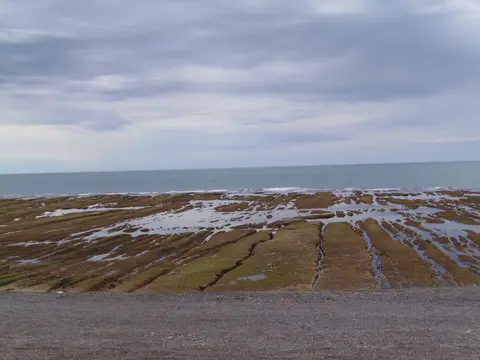
Projecting more than 100 kilometres eastward into the South Atlantic Ocean in Chubut Province's Viedma Department, Peninsula Valdes forms a distinctive mushroom-shaped landmass tethered to mainland Patagonia solely by the narrow Isthmus of Carlos Ameghino. Excluding that isthmus, the terrestrial peninsula spans roughly 3,625 square kilometres (about 360,000 hectares) edged by approximately 400 kilometres of dynamic coastline. Its narrow land neck encloses two vast, sheltered marine basins covering several thousand square kilometres: Golfo San Jose (bordering larger Golfo San Matias) on the north, and Golfo Nuevo between the peninsula and Punta Ninfas on the south. Framed by rocky cliffs climbing up to 100 metres high, shallow bays, tidal mudflats, shifting sand dunes, coastal lagoons, small islands, and pebble beaches, both gulfs remain far calmer and slightly warmer than the turbulent South Atlantic.
Inland across barren plains, Patagonian Desert Steppe dominates the flora, compressing more than half of all plant communities identified across Argentine Patagonia into this single peninsula. Broad wind-scoured plateaus dip into salty endorheic basins, the largest dropping roughly 40 metres below sea level (long regarded as the lowest point in Argentina and South America until Laguna del Carbon was measured deeper). Mean annual precipitation averages just 240 millimetres on the peninsula (and 200 to 225 millimetres inland), falling unevenly across the year with modest April to June peaks and wetter November to February conditions during El Nino Southern Oscillation (ENSO) cycles. Caught between the subtropical high-pressure belt at 30 degrees south and the subpolar low between 60 and 70 degrees south, persistent westerly winds sweep the steppe under a Koppen cold desert climate (BWk) bordering semi-desert (BSk), holding mean annual temperatures around 10.6 degrees Celsius. Mean monthly values range from 8 degrees Celsius in winter (with 0 to 15 degrees Celsius swings and 12 to 20 frost days) up to 18 degrees Celsius in summer, when daytime maxima fluctuate between 15 and 35 degrees Celsius.
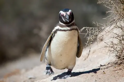
Those arid scrublands support steppe animals seldom observed near ocean wildlife colonies. Guanacos (South American native camelids) share the open flats with the endemic Patagonian mara (a large hare-like rodent) and the lesser rhea. Across tidal mudflats, shifting coastal lagoons, and wetlands partly recognised under the Ramsar Convention, ornithologists document at least 181 bird species, including the endemic white-headed steamer duck, migratory snowy sheathbill, Cape petrel, rock and imperial shags, kelp gulls, and royal, Cabot's, and South American terns. Grouped with neighbouring Punta Leon and Punta Loma, the peninsula carries BirdLife International Important Bird Area recognition for holding roughly 150,000 breeding pairs of Magellanic penguins.
Whales, Elephant Seals, and Intentional Stranding Orcas
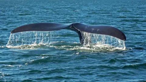
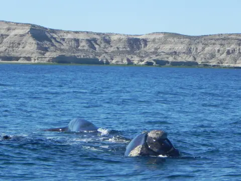
Global recognition under UNESCO Criterion (x) rests squarely on the massive breeding congregations of marine mammals gathering around the 400-kilometre perimeter. Between May and December each year, more than 1,500 southern right whales migrate into the calm, sheltered reaches of Golfo Nuevo and Golfo San Jose to mate, give birth, and nurse newborn calves out of reach of heavy open-ocean swells. Nineteenth- and early twentieth-century commercial whaling nearly wiped out the species before international protection arrived in 1935, and Argentina's National Congress reinforced national protection in 1985 by declaring the southern right whale a Natural Monument.
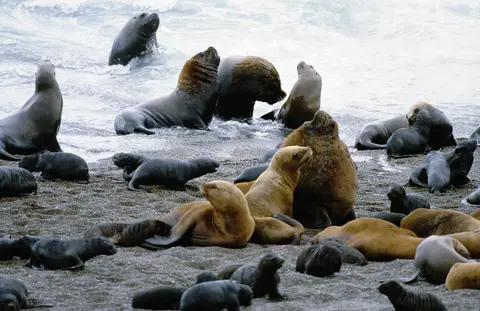
Pinniped rookeries occupy beaches and coastal ledges year-round. Peninsula Valdes holds the northernmost colonies and the sole continental breeding population of southern elephant seals anywhere in Argentina, clustering along sheltered shores such as Caleta Valdes. Southern sea lions, heavily exploited for oil and skins legally through 1953 and illegally into the 1970s, have recovered steadily along rocky promontories including Punta Norte, sharing coastal waters with fur seals.
Those dense seasonal pupping beaches shaped an extraordinary predator adaptation among a small resident population of orcas patrolling the outer Atlantic surf. Rather than hunting solely in deep water, local orcas surf incoming waves straight onto steeply shelving gravel beaches at Punta Norte and Caleta Valdes, intentionally stranding themselves briefly on shore to snatch young sea lions or elephant seals before wriggling back out on receding wash. Still, conservation biologists emphasise one structural boundary constraint: every charismatic marine mammal breeding at Peninsula Valdes is a seasonal visitor roaming vast South Atlantic feeding ranges for much of the year. Outside protected gulfs, vessel strikes, fishing-gear entanglements, marine pollution, and intensive offshore commercial fishing remain leading causes of mortality requiring international treaties beyond Argentina's coastal reserves.
Sheep Estancias, Welsh Gateways, and Marine Reserve Rules
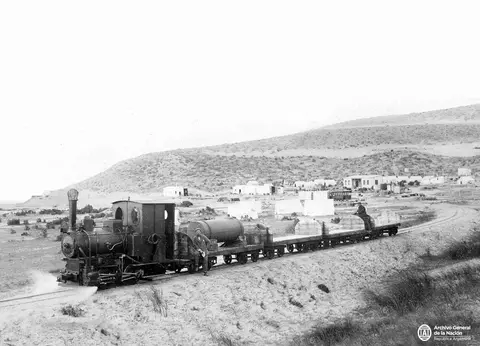
Human history across the peninsula reflects sparse settlement shaped by pastoral grazing and Welsh-Patagonian coastal ties. Prior to European colonisation, Tehuelche communities lived off both steppe and shoreline resources. Later settlers divided interior steppe pastures into large privately owned sheep-farming estancias, where ranch hands historically hunted marine mammals for supplementary oil and skins. Today Puerto Piramides remains the sole permanent village inside the peninsula itself. Across Golfo Nuevo on the mainland sits Puerto Madryn, capital of Viedma Department, counting roughly 103,175 residents in the 2022 census. It traces back to 1863 coastal reconnaissance by Love Jones Parry and Lewis Jones aboard the vessel Candelaria and formal founding on 28 July 1865 when 150 Welsh colonists landed from the clipper Mimosa. Settlers dug early irrigation ditches for first crops and named the harbour Porth Madryn after Jones-Parry's Welsh estate. The town maintains formal twin-town links with Nefyn in North Wales as well as Puerto Montt, Paola, Pisco, and Ciudad del Carmen. Built in 1889 by Welsh, Spanish, and Italian immigrants, the Central Chubut Railway connected Puerto Madryn down to Trelew via the lower Chubut River valley. In June 1982, Puerto Madryn received Argentine prisoners of war repatriated from the Falkland Islands aboard the vessels SS Canberra, MV St Edmund, and MV Norland sailing from Port Stanley. Mainland Puerto Madryn shares a cool arid climate (150 to 200 millimetres annual precipitation) and houses an industrial aluminium smelter.
Provincial conservation architecture matured step by step from the 1960s onward. Early legislation established Touristic Nature Reserves at Punta Norte and Isla de los Pajaros, followed by Golfo San Jose Provincial Marine Park in 1974 and the unified 1983 Nature Reserve for Integrated Tourism Development bringing earlier reserves under one responsible tourism plan. In 1995, Chubut created a strict Golfo Nuevo marine reserve extending five nautical miles offshore around most of the peninsula. Wildlife guards active since the 1970s coordinate field patrols with local police, the National Coast Guard, researchers at the National Centre for Patagonia, and the Chubut Provincial Tourism Organisation under the participatory 1998 Peninsula System Management Plan.
Because private estancias own most terrestrial land, conservation governance requires continuous stakeholder dialogue with ranch owners and mainland municipalities. Onshore priorities include adjusting sheep grazing loads to curb forage competition against wild guanacos and halt historical predator persecution against native carnivores, while managing scarce freshwater supplies across an arid landscape where tourist accommodations inevitably increase wastewater and solid waste. Uncontrolled rubbish dumps risk inflating kelp gull and rat populations that predate vulnerable penguin nests, shorebird eggs, and whale calves along beaches. On the water, regulated whale-watching boats out of Puerto Piramides follow strict distance limits so vessels do not disturb breeding marine mammals, while Puerto Madryn's aluminium smelter, coastal fish-processing plants, municipal sewage outlets, and passing shipping lanes demand strict wastewater controls and spill-response readiness. Even with strong provincial protection inside Golfo Nuevo and Golfo San Jose, every seasonal visitor species remains exposed to ship strikes, fishing-gear entanglement, and overfishing outside Argentine coastal zones across the wider South Atlantic Ocean.
Protected Sectors Across the Peninsula and Isthmus
All vehicular arrivals funnel across the single road linking mainland Chubut over the Isthmus of Carlos Ameghino before branching onto unpaved gravel circuits connecting coastal wildlife reserves.
| Complex Zone | Key Highlights | Access & Ticket Rule |
|---|---|---|
| Istmo Carlos Ameghino & Interpretation Centre | Narrow land bridge separating Golfo San Jose and Golfo Nuevo, topographic relief model, and Isla de los Pajaros view | Primary provincial entry gate and ticket desk; landing on Isla de los Pajaros itself is strictly prohibited |
| Puerto Piramides & Golfo Nuevo Whale Sanctuary | Only town on the peninsula, historic steam rail traces, and five-nautical-mile protected whale breeding waters | Licensed whale-watching boats depart under provincial regulations from May through December |
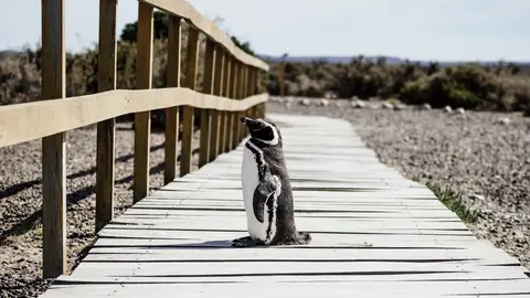
| Punta Norte & Caleta Valdes Headlands | Southern sea lion and continental elephant seal colonies, Magellanic penguins, and orca stranding channels | Visitors remain on elevated boardwalks and cliff overlooks; walking onto breeding beaches is banned |
| Interior Steppe & Salt Lake Basin | 40-metre-below-sea-level salt flats, Patagonian steppe plants, guanacos, maras, and working sheep estancias | Public gravel roads cross interior plains; entering private estancia pastures requires ranch permission or tour arrangements |
Three Coastal and Steppe Signatures Along the Circuit
Driving the gravel perimeter loop from the Ameghino isthmus around Punta Norte and Caleta Valdes reveals three physical features behind the peninsula's biology.
- The Two-Gulf Constriction at Istmo Ameghino: Pausing at the visitor centre on the narrow isthmus lets you look toward Golfo San Jose on the north and Golfo Nuevo on the south simultaneously. Narrow land enclosure buffers both bays from open Atlantic swells and creates calm nurseries for more than 1,500 southern right whales.
- Caleta Valdes Pebble Barrier Spit and Cliff Strata: Along the eastern shore beneath Punta Cantor's cliffs (rising up to 100 metres across the coast), coastal currents throw up a narrow shingle spit. This barrier separates calm tidal lagoons from open surf, forming gentle gravel slopes preferred by moulting elephant seals and patrolling orcas.
- Below-Sea-Level Salt Pans of the Steppe Interior: Looking down across bright salt crusts lying roughly 40 metres below ocean level demonstrates how closed drainage basins and low 240-millimetre rainfall accumulate evaporites amid arid Patagonian steppe scrub.
Time marine trips between June and December to watch southern right whale calves in Golfo Nuevo, or late summer to autumn for peak stranding activity at Punta Norte. Most commercial flyers land at Trelew Airport because of flight restrictions into Puerto Madryn's El Tehuelche Airport (PMY, located 10 kilometres northwest of Puerto Madryn centre). Travellers exploring coastal bluffs, mudflats, and salt basins should carry windproof layers across every season, because steady westerly airflow off the Patagonian plains drives sharp chill off cold ocean currents. Even when summer afternoon temperatures climb toward 35 degrees Celsius inland, gusts remain brisk, while winter mornings between June and August bring crisp coastal frosts across the desert steppe. Keep binoculars handy along coastal gravel circuits connecting Punta Norte, Caleta Valdes, and Istmo Carlos Ameghino. From there you can scan gravel spits for moulting elephant seals, colonial Magellanic penguins nesting among coastal scrub burrows, and shorebirds foraging across tidal flats. Never step past marked perimeter barriers or disturb shoreline breeding zones. Pair Patagonian coast wildlife with Andean glacial lakes in our San Carlos de Bariloche travel guide or explore additional South American natural sites in the UNESCO World Heritage Atlas.