Quick Field Data
- UNESCO Inscription: 1999 (Ref. 936), prehistoric rock art complex in Santa Cruz Province; Criterion (iii)
- Scale & Footprint: 600-hectare core reserve inside a 2,338-hectare buffer zone along the Pinturas River Canyon, featuring rock art spanning roughly 60 by 200 metres across cave walls and cliff overhangs
- Access & Ticketing: Protected within Cueva de las Manos Provincial Park and Perito Moreno National Park; entry requires mandatory guided access along raised walkways (check Santa Cruz provincial tourism and park authority pages for seasonal trail access and ticket fees)
- Arrival Logistics: Commercial passenger flights arrive at Comodoro Rivadavia International Airport (CRD, 288 kilometres east on the Atlantic coast), connecting inland via National Route 40. Perito Moreno town sits 163 to 165 kilometres north via gravel spur roads off Route 40, while Patagonian roads link north to San Carlos de Bariloche (671 kilometres).
Ignimbrite Overhangs and Microclimate in Pinturas Canyon
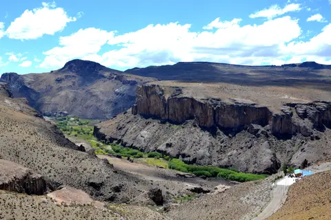
Carved deep into the Deseado Massif across remote northwestern Santa Cruz Province, Cueva de las Manos occupies the stepped volcanic walls of the Pinturas River Canyon in the upper Deseado River basin, roughly 163 to 165 kilometres south of Perito Moreno town. Geologists date the surrounding cliffs to roughly 150 million years ago during the Jurassic period, when volcanic activity laid down dense ignimbrite and ash layers belonging to the Bahía Laura Group and Chon Aike Formation. Over subsequent eras, glacial meltwater rushing down the Pinturas River cut deeply into softer volcanic strata through differential erosion, leaving harder ignimbrite benches jutting out as dry protective shelves above the gorge.
The main cave formed along a pronounced rock-wall fissure eroded far deeper by river currents than adjacent canyon ledges. Facing northeast to capture low Patagonian sunlight, its entrance mouth measures roughly 15 metres high by 15 metres wide and reaches 20 metres into the cliff. Flanking rock outcroppings and long exterior cliff faces carry painted art across roughly 60 by 200 metres. Inside, an upward-sloping bedrock floor narrows the initial 10-metre ceiling clearance to no more than 2 metres at the back wall, forming a sheltered acoustic recess screened from open steppe wind.
That protected canyon geometry formed a hospitable grassland microclimate at 400 to 500 metres elevation during the late Pleistocene and early Holocene, reached via eastern and western ravines from plateau rims at 600 to 700 metres. Steep cliffs blocked fierce westerly winds and moderated winter cold while fostering useful plants, including Schinus molle shrubs for firewood, resins and adhesives, Berberis bushes with edible fruit, medicinal herbs and rush-root tubers. Today, precordilleran steppe weather stays cold and dry, averaging 8 degrees Celsius annually. February warms to 21 degrees Celsius with extremes of 38 degrees Celsius, while July averages minus 3 degrees Celsius and drops to minus 10 degrees Celsius. Annual rainfall estimates span from under 20 millimetres (reported by Ian N. M. Wainwright and colleagues) to 200 millimetres (reported by Gladys I. Galende and Rocío Vega).
Hunter-Gatherer Circuits, Bone Spray Pipes, and Guanaco Hunts
During early Holocene occupation, the Pinturas and Deseado rivers drained eastward across Patagonia into the Atlantic Ocean, providing reliable water for large wild herds of guanacos (Lama guanicoe) and turning the sheltered gorge into an ideal seasonal base for Paleoindian bands. Excavations inside the canyon recovered stone projectile points, a bola stone fragment, side-scrapers and charcoal fire pits mixed with bone remains of guanaco, puma, fox and steppe birds, while non-local obsidian points found nearby reveal extensive trade networks linking cave inhabitants with distant tribal groups. As archaeologist Francisco Mena notes for Middle to Late Holocene Patagonia, neither agriculture nor full pastoral herding ever took root in this steppe region; as surveyor Carlos J. Gradin observed across the rock art, every composition reflects an unbroken hunting-and-gathering way of life.
From around 7,500 BC, parallels with Cerro Casa de Piedra-7 near Lake Burmeister show that Toldense bands and successor hunter-gatherers followed regular seasonal circuits. Groups moved between Pinturas Canyon, the western Central High Plateau and steppe-forest margins bordering Andean glacial lakes, timing migrations to plant ripening and altitude-shifted guanaco birthing seasons. Hunters converged near Cueva de las Manos around November, when newborn guanacos yielded soft pelts. Temporary camps outside the gorge hosted extended families and multi-band gatherings for cooperative game drives. Hunters steered herds into narrow dead-end ravines and struck with bolas, a collective tactic depicted on cave panels alongside rare dart and spear throwers.
Later in prehistory, melting Andean ice sheets let the Pacific-draining Baker River capture upper headwaters that had previously flowed east across the steppe. Falling flows in the Pinturas and Deseado rivers gradually reduced local grazing capacity. Human occupation waned until the last cave dwellers, likely ancestors of historic Tehuelche peoples encountered by 19th-century Europeans, departed around AD 700. UNESCO summaries note earliest cultural horizons 13,000 to 9,500 years ago, while stratified art studies date the paintings between 9,300 and 1,300 years ago (7,300 BC to AD 700). Scholars including Ralph Crane, Lisa Fletcher and Irene Fanning recognise Cueva de las Manos as South America's earliest known cave painting tradition and finest surviving record of early Holocene hunter-gatherers.
Stratified Pigments, Stylistic Waves, and Modern Conservation
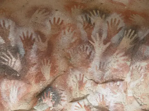
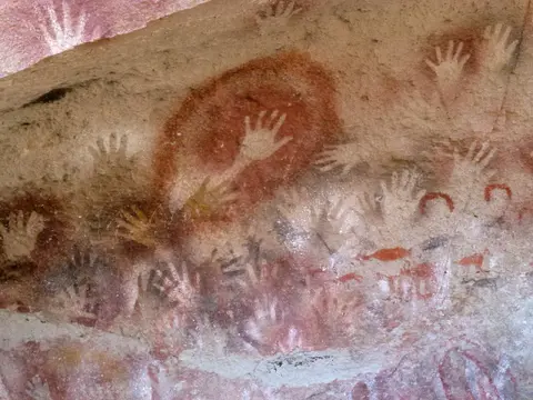
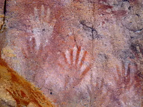
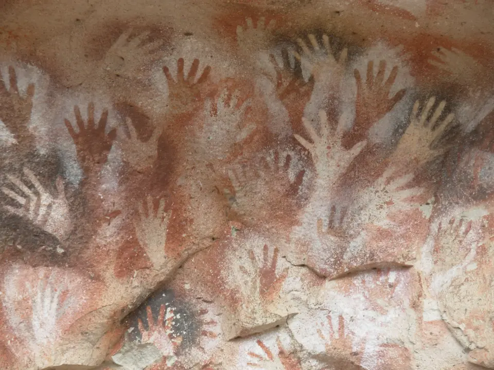
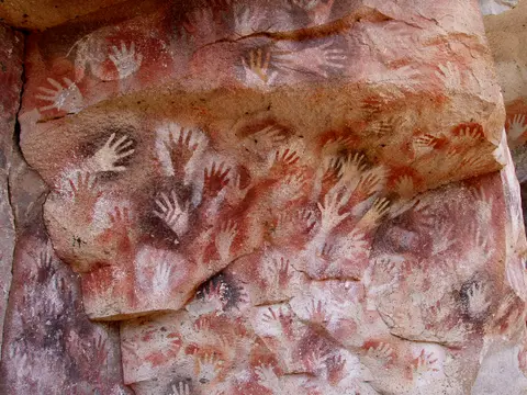
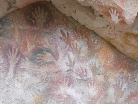
More than 2,000 stencilled handprints cluster across five main concentrations inside the shelter and screening entrance wall, giving the site its Spanish name (Cave of the Hands). Painters ground local mineral pigments, including red and purple iron oxides, white kaolin clay, yellow natrojarosite and black manganese oxide, before mixing them with natural binders. They then blew paint through hollow bone pipes around hands pressed flat against the cliff. Researchers recorded 829 left hands against just 31 right hands, showing most artists braced left palms on stone while holding bone blowpipes in their right hand. Several stencils show missing fingers, interpreted as folded sign-language gestures, ritual signals or frost damage, alongside occasional positive handprints. Across uneven canyon walls, shifting viewer positions alter visual angles, while heavy overlapping turns dense clusters into ochre, white and black palimpsests contrasting with isolated single hands.
Following written accounts by Italian missionary Father Alberto María de Agostini in 1941 and a 1949 La Plata Museum expedition, Argentine archaeologist Carlos J. Gradin began a 30-year study in 1964. Anchoring over 25 years of intensive Patagonian fieldwork, Gradin defined three primary stylistic groups across superimposed painted layers. Earliest naturalistic murals (styles A1 and A2 around 7,300 BC, unmatched regionally) portray lively hunting drives with guanacos, rheas, felines, south Andean deer and running humans. Regional hunting styles A3, A4 and A5 expanded after 6,800 BC before later phases shifted toward schematic animal forms, geometric motifs, zigzags and suns. Researchers verified this chronology through radiocarbon dating of bone spray tubes, pigment chemistry analysis and stratigraphic excavation of a naturally detached painted fragment found in dated floor layers.
Extremely low canyon humidity, intact rock beds and zero water seepage kept sheltered panels crisp for millennia without modern chemical restoration. Yet rising Patagonian tourism introduced vandalism risks, including graffiti, touched paint edges, dust, litter and chiselled rock-chip theft. Legal protection began in 1975 under Santa Cruz Law No. 1024, reinforced by Provincial Decree 133 of 13 May 1981 naming Perito Moreno city Archaeological Capital. Subsequent safeguards included National Historic Monument Law No. 24.225 (20 July 1993), the 1995 INAPL national rock-art study, Provincial Law No. 2472 (1997) and National Law No. 25743 (2003). Site oversight grew through a 1997 management plan, an interpretation centre and the 2006 Site Committee. In 2015, Rewilding Argentina purchased the ranch, established Cueva de las Manos Provincial Park in 2018 and donated it back to public state control in 2020.
Access Zones Around Cueva de las Manos and Pinturas Gorge
To protect exposed mineral pigments and intact archaeological soils across the 600-hectare core and 2,338-hectare buffer zone, visitor movement follows guided walkways and three gravel road corridors off National Route 40.
| Complex Zone | Key Highlights | Access & Ticket Rule |
|---|---|---|
| Main Shelter Overhang & Entrance Screen | 20-metre cave, screening cliff covered in superimposed left-hand stencils (829 left vs 31 right) and five primary painting concentrations | Guided access only along elevated protective boardwalks; touching rock surfaces, flash interference and straying off walkways are prohibited |
| Flanking Canyon Murals (60 by 200 m Span) | Early 7,300 BC style A1/A2 guanaco ambush hunts, geometric zigzags, sun motifs and multi-hue palimpsests | Observed strictly from supervised exterior canyon paths accompanied by park rangers or accredited guides |
| Reception Interpretation Centre | Site orientation exhibits covering mineral pigments, bone spray pipes, obsidian exchange and Gradin's 30-year stratigraphic study | Open during park visitation windows; entry fees and guided group departures are arranged at the reception desk |
| Pinturas Canyon Approaches (Ruta 40 & Bajo Caracoles) | Three gravel corridors: 46-kilometre southern road from Bajo Caracoles, 28-kilometre Route 40 spur and 22-kilometre northern track with 4-kilometre foot trail | Public gravel roads and marked canyon rim hiking trail; check seasonal weather and road status before driving remote steppe tracks |
Three Pigment, Hand-Stencil, and Canyon Details at Cueva de las Manos
- The 829-to-31 Left-Hand Stencil Ratio: Scanning the crowded negative hand clusters at the shelter entrance, look at thumb placement across overlapping layers. With 829 documented left-hand stencils against just 31 right hands, visitors can see how right-handed artists pressed left palms to stone and aimed bone spray tubes with their right, sometimes folding fingers deliberately.
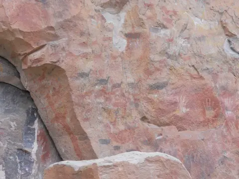
- Naturalistic vs Abstract Guanaco Murals: Move along the exterior overhang panels to compare earlier dynamic red and black guanacos painted during naturalistic hunter-gatherer phases against later stylised, geometric and abstract animal silhouettes and zigzag lines layered directly on top.
- Differential Erosion Along Jurassic Ignimbrite: Step back on the viewing walkway to see how soft horizontal volcanic tuff weathered beneath harder Jurassic ignimbrite caps of the Chon Aike Formation. That profile created both an acoustic amphitheatre for group gatherings and the dry, rain-free roof that preserved fragile mineral pigments for nine millennia.
Steppe Seasons and Patagonian Connections From Río Pinturas
Cold dry conditions dominate this precordilleran steppe year-round, with February daily means warming to 21 degrees Celsius against July averages of minus 3 degrees Celsius. Late spring through early autumn brings clear canyon daylight and reliable driving along gravel approaches from Route 40 and Bajo Caracoles. Commercial passengers fly into Comodoro Rivadavia International Airport (CRD, 288 kilometres east on the Atlantic coast) and travel inland via National Route 40. Based in Perito Moreno town (163 to 165 kilometres north), pair a half-day guided canyon tour with trekking toward Cerro Casa de Piedra near Lake Burmeister. Continue north along Argentina's Andean spine via our guide to San Carlos de Bariloche or explore prehistoric rock art monuments in the UNESCO World Heritage Atlas.