Quick Field Data
- UNESCO Inscription: Inscribed in 2008 (Ref. 1245) as a Cultural site under Criterion (iii).
- Scale & Footprint: Covers 55 hectares across Mount Titano and the walled historic centre, inside a 167-hectare buffer zone within a 61-square-kilometre republic.
- Access & Ticketing: Historic streets, outer fortifications, and Montale's ridge trail open free on foot. Guaita Tower, Cesta Tower's Museum of Ancient Arms, and Palazzo Pubblico require official state museum tickets.
- Arrival Logistics: Major commercial flights use Florence Airport, Peretola (FLR, 101 kilometres west) and Bologna Guglielmo Marconi Airport (BLQ, 114 kilometres northwest). Closer Federico Fellini International Airport in Rimini (RMI, 16 kilometres northeast) handles limited regional traffic. Overland routes link directly to Florence (98 kilometres).
Monte Titano Geology, Fossil Seas, and Saint Marinus's Monastic Refuge
San Marino is a landlocked microstate completely surrounded by Italy. Bordered primarily by Emilia-Romagna's Rimini province and a three-kilometre stretch of Marche's Pesaro and Urbino province, the republic spans just over 61 square kilometres. That compact footprint makes San Marino the fifth-smallest country worldwide and the third-smallest European state after Vatican City and Monaco. Recent demographic counts show a san marino population of 34,042 in 2025 shifting to 33,559 in 2026, with its largest settlement at Dogana in Serravalle while the capital crowns Monte Titano.
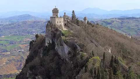
Located just 10 to 13 kilometres inland from the Adriatic Sea near Rimini, mount titano san marino rises 739 to 749 metres above sea level as an abrupt Apennine limestone ridge. Across the northern Po Plain, Italian observers sometimes call this peak Monte Brugola because its vertical profile resembles a hex key. During the Tertiary era, the entire zone lay submerged beneath an ancient sea before powerful tectonic earthquakes occurred. Those upheavals lifted a massive limestone block roughly 80 kilometres away and slid it slowly toward the Adriatic coast, leaving aquatic Miocene shark teeth and a whale fossil preserved today in the Bologna Archaeological Museum.
Although its summit reaches 739 to 749 metres, the bare limestone crag itself rises roughly 200 metres above the surrounding ridge. Mountain springs feed the San Marino River descending west into the Marecchia toward the Adriatic 23 kilometres away, the Ausa River marking the lowest national point at 55 metres, and the Cando stream reaching the coast between Rimini and Riccione. Mediterranean vegetation shifts with slope altitude across chestnuts, oaks, laburnum, cypress, firs, and dry-cliff asparagus, plus the shrub Ephedra nebrodensis. Kestrels, buzzards, barn owls, tawny owls, magpies, roe deer, wild boar, badgers, porcupines, martens, hedgehogs, polecats, hares, and foxes inhabit these wooded cliffs.
Traditional origin accounts place the community's founding in AD 301 under Saint Marinus. Said to have left the Roman island of Rab in modern Croatia with his lifelong friend Leo, the Christian stonemason worked in Rimini before fleeing Diocletianic persecution up Monte Titano. While historians note that early accounts weave miracles with medieval memory, fifth- and sixth-century records by the monk Eugippus confirm a monastic settlement already existed on the mountain. By the eighth century, that sheltered hillside community formed the enduring core around which the free city-state grew.
Seven Centuries of Sammarinese Self-Rule, Treaties, and Dual Captains Regent
Thirteenth-century charters document how local citizens secured legal independence from feudal lords in the surrounding Apennines. In 1291, Sammarinese emissaries appealed to Bishop Ildebrandino Guidi di Romena of Arezzo against tribute demands from the Vicario del Montefeltro, winning a verdict from Rimini jurist Palamede recognising San Marino's tax exemption. Five years later in 1296, citizens petitioned Pope Boniface VIII against renewed Montefeltro podesta claims. Romagna governor Guglielmo Durante and Abbot Ranieri di Sant'Anastasio examined witnesses and sources in a lengthy inquiry that cemented Sammarinese fiscal autonomy.
Borders expanded twice during the late Middle Ages and remained fixed thereafter. Chiesanuova joined the commune voluntarily in 1320, and in 1463 San Marino absorbed Faetano, Fiorentino, Montegiardino, and Serravalle. Sovereignty survived repeated armed threats across Renaissance and early modern Italy. Cesare Borgia occupied San Marino for six months in 1503 until Pope Julius II intervened to restore independence. On 4 June 1543, troops under Fabiano di Monte San Savino got lost in thick fog while attempting a night assault, an escape citizens attributed to Saint Quirinus.
Following Urbino's annexation by the Papal States in 1625, San Marino sought formal Papal protection in 1631 without surrendering domestic governance. Cardinal Giulio Alberoni occupied the state on 17 October 1739, yet Pope Clement XII restored full liberty on 5 February 1740, making Saint Agatha a national patron saint. In 1797, Regent Antonio Onofri persuaded Napoleon through commissary Gaspard Monge to protect the republic, wisely declining offered land expansion to prevent future foreign reprisals. Later, nineteenth-century San Marino sheltered Giuseppe and Anita Garibaldi, signed an 1862 Convention of Friendship with Italy, abolished capital punishment in 1865, issued its own Three Towers postage stamps from March 1877, and granted honorary citizenship to Abraham Lincoln.
Neutrality throughout both world wars brought fierce diplomatic and humanitarian tests. During 1915, Italy cut telephone links over fears that Austrian spies might exploit San Marino's new radiotelegraph station, while two ten-man Sammarinese volunteer units fought or ran a Red Cross field hospital on the Italian front, causing Austria-Hungary to sever ties. After interwar economic strain brought local Fascist Party rule from 1923 to 1943, Allied bombers mistakenly hit the centre and Rimini railway between June and August 1944 despite strict neutrality. San Marino sheltered roughly 100,000 civilian refugees against 15,000 residents when the Gothic Line broke, enduring brief German occupation during September 1944's Battle of San Marino. Allied troops stayed two months before departing, and a postwar coalition held office from 1945 until 1957's Rovereta affair. San Marino joined the Council of Europe in 1988 and the United Nations in 1992, hosting the Parliamentary Assembly of the Mediterranean while using the euro outside the European Union and maintaining its dual six-month Captains Regent presidency.
Guaita, Cesta, Montale, and Historic Centre Fortifications
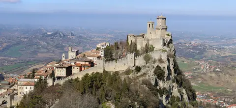
Visitors looking up things to do san marino encounter an intact hill capital untouched by heavy industry. Triple lines of medieval stone walls, gates, and bastions link residential lanes directly to the Three Towers perched along Mount Titano's sheer crest. Built on the western side of the mountain ridge, the historic streets still house working governmental chambers, local Sammarinese-dialect culture, and civic assemblies ranking twenty-ninth on the 2025 Human Development Index. Every tower and civic plaza preserves seven hundred years of continuous public capital function.
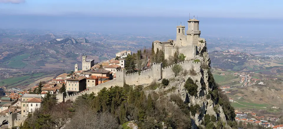
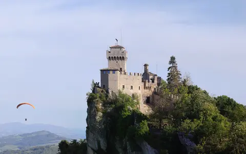
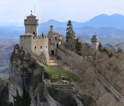
Guaita, known as the First Tower, is the oldest defensive stronghold on the limestone crest. Raised in the eleventh century, it briefly held prisoners before repeated rebuilds gave it its present crenelated outline during fifteenth-century wars against the House of Malatesta. Further south along the ridge stands Cesta, the Second Tower, occupying Monte Titano's highest summit atop older Roman fort foundations. Built in the thirteenth century and framed by defensive outer walls, Cesta has housed the Museum of Ancient Arms since 1956, displaying over 1,550 medieval to modern weapons.
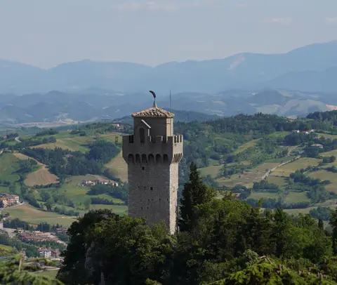
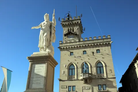
Montale crowns the smallest and southernmost summit as the Third Tower. Constructed during the fourteenth century to watch against expanding Malatesta forces, Montale also served as a secure prison. Its sole doorway opens seven metres above ground level with no stone staircase, so interior visits remain closed even as cliff trails reach its pentagonal base. Below the three summits, paved streets thread through San Francesco Gate, Porta della Rupe, and the Theatre Bastion past fourteenth- and sixteenth-century convents, the eighteenth-century Titano Theatre, the neoclassical Basilica of San Marino, and the nineteenth-century Palazzo Pubblico.
Preservation across this hilltop capital reflects changing conservation philosophies over time. Between the late nineteenth century and the 1930s, architect Gino Zani directed comprehensive restoration and Romantic medievalisation across city gates, battlements, and civic facades. Rather than eroding authenticity, those early twentieth-century works now form part of the monument's recorded architectural story. No major urban disruptions have reshaped the historic core since the 1930s, leaving public squares, fortifications, and surrounding limestone slopes exceptionally cohesive.
Access Zones Across San Marino Historic Centre and Mount Titano
San Marino's compact 55-hectare core rises steeply from lower defensive gates up to exposed limestone peaks. Walking paths tie every landmark together once visitors reach outer car parks or bus stops near the historic gates.
| Complex Zone | Key Highlights | Access & Ticket Rule |
|---|---|---|
| San Francesco Gate & Lower Centre. | Fourteenth-century western town gate, sixteenth-century convents, eighteenth-century Titano Theatre, and Theatre Bastion overlooking western valleys. | Pedestrian streets and outer walls open free year-round. Check official theatre box offices for indoor stage tours. |
| Piazza della Libertà & Upper Civic Core. | Nineteenth-century Palazzo Pubblico, Statue of Liberty, neoclassical Basilica of San Marino, and cliff terraces facing the Apennines. | Public squares remain free to cross. Indoor Palazzo Pubblico state chambers require paid tickets checked via state museum offices. |
| Guaita & Cesta Ridge Towers. | Eleventh-century Guaita ramparts, thirteenth-century Cesta fortress on Roman ruins, and the Museum of Ancient Arms holding 1,550 weapons. | Cliffside linking paths stay open to walkers free. Entering Guaita and Cesta courtyards requires official museum admission passes. |
| Montale Summit & Eastern Limestone Cliffs. | Fourteenth-century pentagonal prison watchtower, Tertiary marine fossil beds, Mediterranean oak woodland, and soaring paragliders. | Exterior ridge trails remain open free along the summit crest. Montale Tower's interior stays closed to visitors. |
Three Architectural and Heraldic Details on Mount Titano's Ridge
- Elevated Prison Doorway at Montale Tower: Walk along the southern crest path to inspect the outer wall of the fourteenth-century Montale fortress. Its sole doorway sits roughly seven metres above ground level with no stone stair, demonstrating defensive medieval prison engineering against Malatesta siege teams.
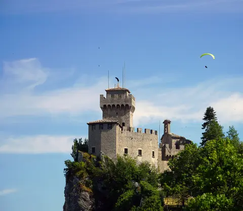
- Ostrich-Plume Weathervanes and the San Marino Flag: Look upward at the metal vanes spinning atop Guaita, Cesta, and Montale. Each features an ostrich feather, echoing the Italian word penne for plumes and peaks, matching the Three Towers coat of arms centred on the horizontal white-and-blue san marino flag.
- Gino Zani's Early Twentieth-Century Medievalisation: Compare uniform limestone battlements around Porta della Rupe with the neo-Gothic Palazzo Pubblico facade. Restorations directed by Gino Zani through the 1930s stitched surviving medieval gates and nineteenth-century civic structures into a cohesive limestone capital while safeguarding historic street layouts.
Best Month to Visit San Marino and Connecting From Florence
Selecting the best time to visit san marino depends largely on clear mountain visibility above the coastal plain. Summer highs reach around 26 degrees Celsius with expansive Adriatic views, whereas winter lows drop to minus 7 degrees Celsius amid 560 to 800 millimetres of annual rainfall. Late spring and early autumn frequently deliver the best month to visit san marino, pairing mild daytime air with quieter ramparts than mid-summer weekends. Pack supportive walking footwear regardless of season, because steep stone lanes climb continuously between gates, convents, and summit towers.
Visitors planning how to get to san marino commonly combine Italian Adriatic rail routes to Rimini with regional bus or road ascents up the Apennine foothills, since 1944 bombing damaged the former cross-border railway. Travellers checking how to get to san marino from florence cross central Italy overland via Tuscany and Emilia-Romagna rail or highway links toward Rimini, pairing smoothly with Florence (98 kilometres west). International gateways operate through Florence Airport (FLR, 101 kilometres) and Bologna Airport (BLQ, 114 kilometres), whereas Rimini's Federico Fellini Airport (RMI, 16 kilometres) focuses on limited regional schedules. Explore neighbouring Italian heritage sites across the UNESCO World Heritage Atlas.