


























Quick Field Data
- UNESCO Inscription: 1991 (Cultural heritage site in the southeastern section of Piauí state across Brazil’s Northeast Region)
- Scale & Footprint: 129, 140 hectares (1,291.4 square kilometres or 319,000 acres) enclosed by a circumference of 214 kilometres across over 300 documented archaeological sites
- Access & Ticketing: Managed by Brazilian park authorities alongside the South-American Pre-Historic Men Foundation (FUMDHAM); check the official site for mandatory accredited guide bookings, trail permits, and museum entry
- Arrival Logistics: São Raimundo Nonato, Coronel José Dias, Canto do Buriti and São João do Piauí provide the principal municipal gateways along the park perimeter in southeastern Piauí
Sandstone Canyons of the Caatinga and Prehistoric Settlement in the Americas
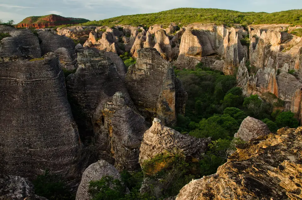
Carved into the dramatic sandstone cuestas, narrow canyons, and eroded plateaus of southeastern Piauí state in Brazil’s Northeast Region, Serra da Capivara National Park protects the densest and oldest concentration of prehistoric rock shelters and cave paintings on the American continent. Protected in Brazil as a national park in 1979 to safeguard its fragile archaeological deposits and inscribed on the UNESCO World Heritage Atlas in 1991, the reserve spans 129, 140 hectares, or 1,291.4 square kilometres (319,000 acres), with a boundary circumference of 214 kilometres. Taking its Portuguese name, Parque Nacional Serra da Capivara, meaning "Capybara Hills", from the plateau range that defines the landscape, the park straddles the municipal territories of São Raimundo Nonato alongside Canto do Buriti and São João do Piauí, and the newer municipalities dismembered from them after 1991: Coronel José Dias, created from São Raimundo Nonato in 1992, Brejo do Piauí, separated from São João do Piauí in 1994, and João Costa, separated in 1995.
Geologically, the plateau stands at the contact zone between two major structural provinces: the sedimentary Maranhão-Piauí sedimentary basin and the bordering depression of the São Francisco River valley. Over millions of years, seasonal water erosion and wind abrasion hollowed out hundreds of overhanging sandstone shelters, locally termed tocas, along the base of vertical cliff walls and inside sheltered valleys, plains, and gorges. Surrounding these rock overhangs is the morphoclimatic biome of the Brazilian Caatinga, a semi-arid thorn woodland and scrub formation characteristic of Northeastern Brazil. During the long dry season that extends from May to December, most trees and shrubs shed their foliage completely, lending the canyons and valleys a striking silvery hue before summer rains restore green foliage across the Capivara-Confusões Ecological Corridor, established in 2006 to connect the park with the neighbouring Serra das Confusões National Park.
What has placed Serra da Capivara at the centre of international archaeological debate is its extraordinary chronological depth. Led for decades by head archaeologist Niède Guidon and researchers from the South-American Pre-Historic Men Foundation, FUMDHAM, alongside specialists from the University of São Paulo and French teams including Eric Boëda, excavations across more than 300 archaeological sites have uncovered stone tools, charcoal hearths, human skeletons, and ochre wall paintings that challenge long-held assumptions regarding when humans first arrived in the Americas. While several rock paintings are dated to more than 25,000 years old and UNESCO documentation notes chronologies invoked between 50,000 and 30,000 years Before Present, optically stimulated luminescence and radiocarbon analyses at key shelters confirm a dense pre-Columbian and pre-Cabraline human presence stretching back into the Late Pleistocene. Research published in 2012 by geological teams from the University of São Paulo, including Janaina Santos, Alcina Magnólia Franca Barreto, and Kenitiro Suguio, examined the Quaternary sediment deposits across the Serra da Capivara National Park and southeastern Piauí state, while international coverage in the New York Times by Simon Romero in March 2014 highlighted how the discoveries across the Capivara mountain range forced scholars to reconsider traditional models of human arrival and settlement density across the Americas during the pre-Cabraline Era. Located between latitudes 8 degrees 26 minutes 50 seconds and 8 degrees 54 minutes 23 seconds south and longitudes 42 degrees 19 minutes 47 seconds and 42 degrees 45 minutes 51 seconds west, the protected IUCN Category II park preserves both the fragile sandstone shelters and the surrounding semi-arid Caatinga valleys.
Pedra Furada, Sítio do Meio, and the Painted Shelters
Across the sandstone cliffs of the park, prehistoric artists used iron oxide ochres in shades of red and yellow alongside black charcoal and white kaolin clays to paint thousands of narrative scenes depicting hunting rituals, ceremonial dances, acrobatic figures, ceremonial trees, and extinct Pleistocene megafauna as well as deer, jaguars, capybaras, rheas, and armadillos. Dry cliffs protect the ancient pigments. Foremost among the excavated shelters is Pedra Furada, named after the monumental wind-eroded sandstone arch that frames the valley skyline. Stratified deposits at Pedra Furada, including the Upper Pleistocenic phase designated Pedra Furada 3, yielded flaked quartz and quartzite cobbles alongside charcoal layers that sparked global scientific reassessment of Pleistocene settlement in South America.
Second in archaeological importance only to Pedra Furada is Sítio do Meio, an expansive overhanging rock shelter where the absence of seasonal waterfalls plunging over the cliff lip allowed exceptional preservation of Pleistocene strata and stone industries. Excavations at Sítio do Meio have recovered at least 98 flaked stone artefacts dated to older than 12,500 BP, alongside ancient hearths and early ceramic fragments. Not far away, investigations at the shelter of Toca da Tira Peia have uncovered stone tools buried in Quaternary sediments dated through optically stimulated luminescence to around 22,000 years Before Present.
Complementing these deep stratigraphic digs are richly painted rock art galleries scattered throughout the canyons, including Toca da Pena, Baxao da Esperanca, and Lapa do Boquete directly to the south. Beyond human prehistory, the park has also become a crucial field site for primatology and evolutionary ethology: wild bearded capuchin monkeys inhabiting the dry Caatinga valleys have been documented using the largest known tool kit of any wild capuchin population, selecting heavy quartz cobbles as hammers and anvils to crack tough palm nuts, loosening hard soil with stones to dig for tubers and arthropods, and using stripped sticks as probes while employing stone-banging displays during social communication.
Navigating the Canyon Circuits, Pedestrian Boardwalks, and Museums
Visiting Serra da Capivara National Park requires hiring an accredited local guide through São Raimundo Nonato or Coronel José Dias, as entry onto the park's network of unpaved scenic drives and stone hiking trails is strictly regulated to protect the open-air rock art panels. Well-maintained elevated walkways, staircases, and night-illuminated viewing platforms make dozens of shelters accessible to visitors of varying mobility, while the surrounding municipalities host major research and exhibition collections.
- Pedra Furada canyon circuit and the sandstone arch lookout: Begin in the morning at the flagship trail sector near Coronel José Dias to walk beneath the painted overhangs of the Pedra Furada valley, where miniature red ochre figures leap and hunt across the pale cliff face. Climb the stepped stone trail to the viewpoint overlooking the circular natural arch of Pedra Furada, and arrange an evening return visit to the illuminated rock shelter galleries where floodlights highlight overlapping layers of prehistoric scenes against the night sky.
- Sítio do Meio, Toca da Pena, and watching wild bearded capuchins: Dedicate a second circuit to the sheltered valley floor around Sítio do Meio and Toca da Pena, where guides explain how Pleistocene toolmakers selected river cobbles and how dry microclimates preserved organic deposits over millennia. Along the shaded canyon bottoms, quiet observers frequently encounter troops of bearded capuchin monkeys striking stone hammers against rock anvils to forage for seeds and roots in the dry leaf litter.
- Museum of the American Man in São Raimundo Nonato: Complete your field visit in São Raimundo Nonato at the Museum of the American Man, maintained by FUMDHAM in collaboration with institutions such as the University of São Paulo and its Museum of Archeology and Ethnology. The museum's galleries display Pleistocene and Holocene lithic tools from Pedra Furada, Sítio do Meio, and Toca da Tira Peia, prehistoric funerary urns, megafauna fossils, and chronological reconstructions of early human migration across South America, complemented by research archives, photographic records, and digital collections shared through the Brazilian Ministry of External Relations and Google Arts and Culture that connect Serra da Capivara with wider Brazilian rock art landscapes such as the Cavernas do Peruaçu Environmental Protection Area.
