


























Quick Field Data
- UNESCO Inscription: 1990 · Extended 1993 as the world's first UNESCO Cultural Landscape · Mixed Site · Criteria (vi), (vii), (viii).
- Scale & Footprint: 795.96 km2 (or 307.32 sq mi, incorporating the 51.29 km2 Pihanga Scenic Reserve) around the active volcanoes Ruapehu, Ngauruhoe as well as Tongariro in Ruapehu and Taupō districts
- Access & Ticketing: Managed by the New Zealand Department of Conservation (DoC) under the National Parks Act 1980 with free park entry; since 2023 a mandatory online booking system applies to hikers walking the Tongariro Alpine Crossing
- Arrival Logistics: Located in the central North Island 338 km south from Auckland and 337 km north from Wellington along State Highways 1, 4, 47, 48 alongside 49 and the North Island Main Trunk railway at Waimarino
Subduction Volcanism, Crater Lake Lahars as well as Alpine Ecological Zones
Rising across the volcanic plateau of the central North Island of New Zealand around coordinates 39.1463 S and 175.6501 E, a short distance southwest of Lake Taupō, Tongariro National Park is New Zealand's earliest national park and the sixth oldest national park anywhere in the world. Sacred volcanic cones command the central plateau here. Covering 795.96 square kilometres (307.32 square miles) across Ruapehu District and Taupō District, including the detached 51.29-square-kilometre (19.80 sq mi) Pihanga Scenic Reserve encompassing Mount Pihanga, the Kakaramea-Tihia Massif alongside Lake Rotopounamu, the park was inscribed by UNESCO for its natural volcanic phenomena in 1990 and re-inscribed under revised Criterion (vi) in 1993 as the very first property on the World Heritage List recognised as a Cultural Landscape.
Geologically, the massif stands at the southern terminus of a 2,500-kilometre-long (1,600-mile) chain of volcanoes stretching north to Samoa along the tectonic boundary where the Pacific Plate subducts beneath the Australian Plate and melts within the asthenosphere. Volcanic activity has built these mountains for over two million years: while Pihanga and the Kakaramea-Tihia Massif in the north last erupted more than 20,000 years ago, the three central peaks of Mount Ruapehu, Mount Ngauruhoe as well as Mount Tongariro remain active composite and cone volcanoes sculpted by mountain glaciers. Mount Ruapehu, described in the 1990 IUCN World Heritage nomination as one of the most active composite volcanoes in the world, cradles a glacial Crater Lake whose interaction of rising magma and meltwater produces periodic mudflows (lahars) and ash-and-steam eruptions, including evacuations in September 1995, a 2007 lahar event alongside the 2012 eruption of the Upper Te Maari Crater on Mount Tongariro that closed tracks until May 2013.
Because the three volcanoes are the first major highland barrier encountered by moisture-laden westerly winds off the Tasman Sea (apart from Mount Taranaki), climate and rainfall shift dramatically across the massif. While Ohakune at 610 metres receives 1,250 mm (49 in) of annual rain, Whakapapa Village at 1,119 metres receives 2,200 mm (87 in) with an average temperature of 13 °C (ranging from 25 °C in summer to -10 °C in winter) as well as Iwikau Village at 1,770 metres receives 4,900 mm (190 in). On the eastern leeward rain shadow of Mount Ruapehu lies the 100 km2 (39 sq mi) Rangipo Desert (Te Onetapu) along State Highway 1 (the Desert Road), where 1,500 to 2,500 mm of rain still leaves a barren alpine desert of frost-heaved pumice and drying winds. Major rivers rise on these slopes, including the sacred Waikato River, the Whangaehu, Wahianoa, and Mangawhero rivers on Ruapehu as well as the Whanganui River, Mangatepōpō Stream alongside Tāwhitikuri Stream on Tongariro.
Vegetation transitions sharply with altitude and past Taupō pumice eruptions. Below State Highway 47 grow podocarp-broadleaf rainforests of rimu, kahikatea, Hall's totara, northern rātā, kāmahi as well as kaikawaka over mountain cabbage trees, crown fern, kānuka alongside mānuka. Slopes above 1,000 metres carry red, silver as well as mountain beech with summer red mistletoe, giving way between 1,100 and 1,550 metres to red tussock (Chionochloa rubra), mountain inaka, snow totara, and alpine orchids as well as above 1,770 to 2,000 metres to mountain daisies, mountain carrot, and crustose lichens. Over 56 bird species live here, including the North Island brown kiwi, blue duck, kākā, New Zealand falcon (kārearea), North Island fernbird as well as double-banded plover and tūī, bellbird, morepork (ruru), whitehead (pōpokotea), wētā alongside New Zealand's short- and long-tailed bats. Conservation by DoC and Project Tongariro (founded in 1984) targets wilding pines (halted by 2023 under the 2016 Conifer Control Programme) and invasive calluna heather (curbed across 35,000 ha since 2018 by the heather beetle Lochmaea suturalis introduced in 1996, though dry heather fuelled a 2,800-hectare wildfire near Waimarino in November 2025).
Māori Tapu Summits, Horonuku's 1887 Gift, and Historic Park Landmarks
The park lies within the ancestral tribal territories (rohe) of two primary Māori iwi: Ngāti Rangi across southern and south-western Ruapehu and Ngāti Tūwharetoa across the north and west, joined by the upper Whanganui tribes of Te Korowai o Wainuiārua and Ngāti Hāua. In Māori oral tradition, the ancestor Ngātoro-i-rangi climbed the peaks 30 generations ago to claim the land, while legend recounts that the warrior mountains Tongariro and Taranaki fought for the love of Pihanga (or Ruapehu), leaving the twin crater basins of the Tama Lakes (Ngā puna a Tama) when defeated Taranaki fled west along the Whanganui River; around 1750, the explorer Te Rangihiroa gave his name to Blue Lake (Te Wai-whakaata-o-te-Rangihiroa, Rangihiroa's mirror) and his sister Te Maari's name to the Te Maari craters.
Because the volcanic summits are revered as the sacred heads of ancestors (tapu), Chief Mananui Te Heuheu Tūkino II (who perished in an 1846 landslide and was laid in a pataka at Pukawa before burial on Tongariro and 1910 reinterment at Waihī) placed a strict tapu on the peaks after European botanist John Bidwill climbed Mount Ngauruhoe alone in March 1839, barring Dieffenbach, Governor George Grey, and Hochstetter from ascending and forbidding George French Angas from sketching the peaks. To prevent European land sales, Mananui's son Te Heuheu Tūkino IV (Horonuku) arranged an 1886 Native Land Court survey and on 23 September 1887 gifted 26.4 km2 (10.2 sq mi) of the sacred summits of Tongariro, Ngauruhoe, and Ruapehu to the Crown (despite a counter-petition by Te Moanapapaku Te Huiatahi representing 180 people and 200 whare). Expanded to 252.13 km2 under the October 1894 Tongariro National Park Act by 1907, surveyed in 1908 by Leonard Cockayne, Edward Phillips Turner, and Robert Speight, and enlarged to 586.8 km2 in 1922 and 795.96 km2 with Pihanga in 1975, the park's spiritual significance was championed in 1993 by Tumu Te Heuheu and examined by the Waitangi Tribunal between 2004 and 2013.
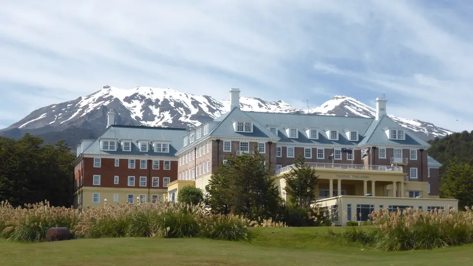
Early twentieth-century rail and road links created a rare ensemble of heritage buildings inside the park. Along the 1908 North Island Main Trunk railway between Ohakune and Horopito stand the curved steel-truss Taonui Viaduct (1907) and the 284-metre Hapuawhenua Viaduct (1908, restored as a walking and cycling trail in 2009), while on the north-eastern slope of Ruapehu stands the 1904 Waihohonu Hut, New Zealand's oldest surviving mountain hut. At Whakapapa Village, reached by motor car up the upgraded Bruce Road in August 1925 following the Ruapehu Ski Club founded skiing in 1914 and built the first 1,770-metre hut in 1923, stand the 1924 Fergusson Cottage (named after Lady Fergusson's August 1926 stay) and the Category 1 Chateau Tongariro (Grand Chateau), a 95-bedroom pre-Depression resort opened in 1929 by the Mount Cook Tourist Company and closed permanently on 5 February 2023 due to seismic risks.
Walking the Tongariro Alpine Crossing and Respecting Sacred Summits
Surrounded by gateway towns including Tūrangi, Waimarino (National Park Village), Ohakune, Waiouru, Horopito, Pokaka, Erua, and Raetihi, the park supports summer tramping and winter skiing across three Ruapehu ski fields: Whakapapa (5.5 km2 with 12 lifts and 46 club huts at Iwikau Village), Turoa (5 km2 with nine lifts leased by the Māori collective Pure Tūroa in November 2023), and the 1.7 km2 club field of Tukino.
- Tongariro Alpine Crossing and the 2017 DoC summit advisory: Reserve your mandatory pass through the 2023 DoC booking system (introduced after hiker numbers climbed between 1990 and 2015 from 10,000 to 125,000) before boarding a shuttle to Mangatepopo Road. Follow the one-day alpine track past volcanic craters and Blue Lake (Te Wai-whakaata-o-te-Rangihiroa), respecting the 2010 trail realignment that avoids the private 39-hectare Ketetahi hot springs trust land and honouring the 2017 DoC and iwi advisory not to climb the sacred tapu summits of Ngauruhoe and Ruapehu or touch sacred crater lakes.
- Great Walks, Waihohonu Hut, and Te Ara Mangawhero cycling trails: Extend your trek onto the two- to four-day Tongariro Northern Circuit Great Walk or the multi-day Round the Mountain Track (three to six days) past the 1904 Category 1 Waihohonu Hut, or ride a mountain bike or e-bike along the 284-metre 1908 Hapuawhenua Viaduct, the Old Coach Road, the Pillars of Hercules track, and the 11.4-kilometre Te Ara Mangawhero loop track opened by Ngāti Rangi and DoC on 4 November 2024 between Mount Ruapehu and Ohakune.
- Whakapapa Village heritage and alpine weather preparedness: Begin at the Whakapapa Visitor Centre to view the plaque commemorating Horonuku's 1887 gift and inspect the exterior of the 1929 Chateau Tongariro and 1924 Fergusson Cottage (noting filming locations nearby from The Lord of the Rings, the 1983 film Wild Horses, the 1988 film Willow, and Hunt for the Wilderpeople). Because sudden blizzards, flash floods, and volcanic alerts pose serious alpine hazards (commemorated at the 1927 Horace Holl and 1931 Warwick Stanton memorials that led to the November 1931 Mountain Guides Act), carry full waterproof and thermal gear year-round and consult our UNESCO World Heritage Atlas.
