Quick Field Data
- UNESCO Inscription: 2007 (Ref. 1255), Namibia's first World Heritage Site; Criteria (iii) and (v)
- Scale & Footprint: 57.4269-hectare core zone (0.6 square kilometres) surrounded by a 91.9-square-kilometre buffer zone along the Aba Huab valley in southern Kunene Region
- Access & Ticketing: Managed jointly by the Twyfelfontein-Uibasen Conservancy and local tourism partners under Namibia's National Heritage Act 2004. Unsupervised walking is forbidden, and all visitors must hire official site guides at the reception visitor centre (check official Namibian heritage and conservancy channels for current fees).
- Arrival Logistics: No major scheduled commercial airport sits nearby. The valley lies 20 kilometres south of the C39 road between Sesfontein and Khorixas via district gravel road D3214. A private gravel airstrip serves Twyfelfontein Country Lodge, while overland drives link southeast to Windhoek (354 kilometres).
Mount Etjo Sandstone Aquifers and the Jumping Waterhole
Carved across sun-baked sandstone slopes in Namibia's southern Kunene Region, formerly known as Damaraland, Twyfelfontein carries the official Damara/Nama name ǀUi-ǁAis, meaning jumping waterhole. Positioned along the dry banks of the Aba Huab River within the Huab valley of the Mount Etjo geological formation, the archaeological core of 57.4269 hectares sits wedged inside a rugged transitional belt where semi-desert meets sparse savanna and shrubland. Rainfall averages less than 150 millimetres annually across stark diurnal temperature swings shifting from 10 to 28 degrees Celsius during July winter days up to 21 to 35 degrees Celsius across November summer afternoons.
Human life and ritual gathered in this dry valley because an impermeable shale layer trapped groundwater beneath porous Mount Etjo sandstone, forcing a slow spring to the surface even when surrounding rivers ran dry. For 6,000 years, reliable water drew mobile desert communities back to this narrow valley beneath flat sandstone table mountains. The Afrikaans name emerged in 1947, when settler David Levin tested farming prospects and bought the drought-stricken land to graze livestock. Struggling to pump enough water for his family and herd, he was teased by an Afrikaans-speaking friend as David Twyfelfontein (David Doubts-the-spring). Levin registered his farm in 1948 as Twyfelfontein, more precisely meaning uncertain or questionable spring.
Even today, that local name operates in two overlapping senses for travellers crossing Kunene. Strictly, the World Heritage perimeter protects the 0.6-square-kilometre core engraving field (archaeologically Twyfelfontein 534) inside a 91.9-square-kilometre buffer zone. There, grazing is restricted and tourism facilities are barred so desert horizons remain intact. More broadly, turning 20 kilometres south off the C39 highway between Sesfontein and Khorixas onto road D3214 links Twyfelfontein's boulders with wider Huab basin geology. Regional itineraries pair the site with the volcanic Organ Pipes, Burnt Mountain, Doros crater and the fossilised trunks of the Petrified Forest, co-managed through joint operations with the Twyfelfontein-Uibasen Conservancy.
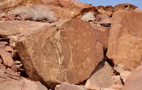
San Ritual Petroglyphs, Red Ochre Shelters, and Khoikhoi Marks
Stone Age hunter-gatherers of the Wilton cultural tradition entered the Huab valley roughly 6,000 years ago and produced nearly all figurative animal engravings and painted shelter panels. British Museum radiocarbon summaries span roughly 5,850 to 180 years before present, while wider archaeological comparisons place most engravings between 6,000 and 1,000 years old. Some researchers suggest the earliest incisions could approach 10,000 years before pastoralists arrived around AD 1000. Between 2,000 and 2,500 years ago, Khoikhoi herders related to the San occupied the valley around the jumping waterhole, introducing distinct geometric motifs and domestic stone hollows.
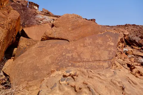
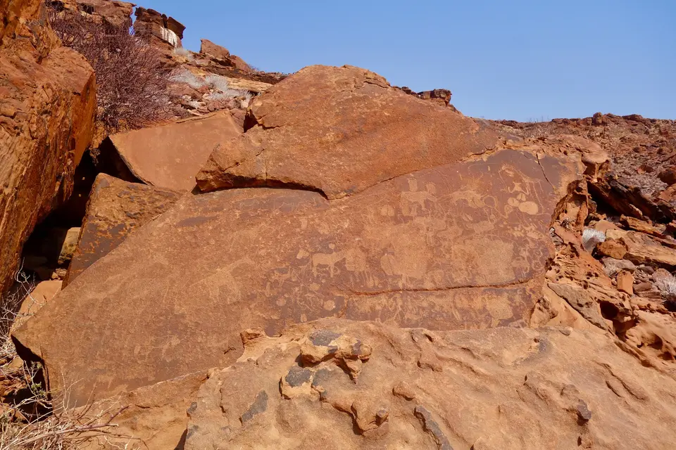
Systematic fieldwork begun in 1950 by German researcher Ernst Rudolph Scherz (culminating in his 1975 volume) recorded over 2,500 rock engravings on 212 sandstone slabs across 14 or 15 sub-sites. Modern surveys estimate more than 5,000 individual depictions across the wider basin. Unusually for southern African rock art, Twyfelfontein also preserves red-ochre paintings at 13 locations, concentrating human figures inside six overhanging shelters. Combining dense petroglyph panels and painted ochre shelters side by side makes the valley exceptionally rare in Africa. Together, both traditions form a continuous record spanning at least two millennia of ritual life tied to seasonal desert water.
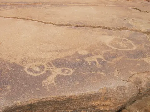
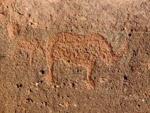
Researchers divide the carved corpus into three clear categories. First, naturalistic figurative imagery portrays big game such as rhinoceroses, elephants, ostriches and giraffes alongside detailed human and animal spoor footprints. Prominent shamanistic panels include the famous Lion Man, a lion whose elongated, kinked rectangular tail ends in a six-toed pugmark. That detail signals spiritual human-animal transformation during trance ceremonies rather than simple hunting magic. Early Scherz surveys identified apparent coastal fauna, including a sea lion, penguins and possible flamingos hinting at journeys over 100 kilometres to the Atlantic. However, modern fieldwork led by Sven Ouzman questioned those labels, reinterpreting the eroded shapes as local wildlife such as giraffes.
Second, later Khoikhoi herders added non-figurative geometric pictograms such as pecked circles and rows of dots tied to pastoralist group identity. Third, flat slabs bear practical indentations worn through daily use, including shallow seed-grinding hollows, board-game grids and resonant gong stones that ring clearly when struck. Excavations across two Late Stone Age valley sections, documented in works such as Peter Breunig's archaeological guide, corroborate the shamanic reading. Archaeologists uncovered quartzite tools suited for chiselling rock, woodworking and leatherwork alongside ostrich eggshell beads, charcoal and plain pottery shards probably left by later early farmers. Food remains consist mainly of small antelope, rock dassies and lizards rather than the rhinos, elephants and giraffes carved into sacred cliffs.
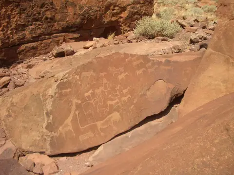
Desert Varnish Patina and Twentieth-Century Conservation Shifts
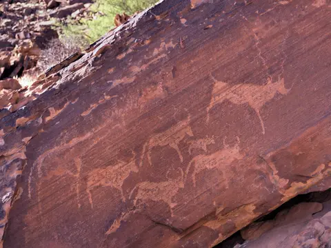
Every engraving at Twyfelfontein takes advantage of a striking natural chemical skin covering Mount Etjo sandstone slabs. Over long arid eras, iron and manganese oxides bake onto exposed stone surfaces as a hard brown or dark grey crust known as desert varnish. Stone Age artists used sharp quartzite chisels and hammerstones to peck and incise straight through that dark outer patina, exposing the paler, reddish-yellow sandstone interior underneath and turning whole boulder faces into high-contrast ritual friezes visible from across the valley floor.
Modern written records begin in 1921 when topographer Reinhard Maack, also famous for discovering Brandberg's White Lady painting, reported valley petroglyphs before David Levin's 1947 survey and Scherz's 1950 documentation. Under South Africa's apartheid-era Odendaal Plan, the government later bought Levin's farm for the Damaraland bantustan, and white settlers departed in 1965. South West African authorities proclaimed Twyfelfontein a National Monument on 15 August 1952, yet the remote boulders remained unguarded until 1986. Nature reserve status arrived too late to stop early graffiti, casual rock-chipping and the early 20th-century removal of one engraved panel to Windhoek's National Museum.
Today, Section 54 of Namibia's National Heritage Act 2004 and a 2005 Management Plan protect Twyfelfontein, Namibia's sole World Heritage Site from 2007 until the Namib Sand Sea joined in 2013. That regime ended unsupervised hiking across fragile terraces where open paths once skirted exposed panels. Visitors walk exclusively with trained Twyfelfontein-Uibasen Conservancy guides on fixed walkways. A joint venture operates the lodge, campsite and visitor centre, while grazing and new construction remain barred inside the 0.6-square-kilometre core. Conservation monitors still watch an earlier compromise closely. In 1999 and 2000, the conservancy allowed Twyfelfontein Country Lodge inside the Zeremonienplatz (Seremonienplatz) sector of the 91.9-square-kilometre buffer zone, a step evaluators noted as damaging rock-art setting integrity.
Access Zones Across the Twyfelfontein Valley
Because unsupervised roaming is strictly barred inside Twyfelfontein 534, guided trails split the sandstone valley into distinct thematic routes centred on major boulder concentrations and painted shelters.
| Complex Zone | Key Highlights | Access & Ticket Rule |
|---|---|---|
| Visitor Centre & Core Valley Engraving Loops | Lion Man panel, rhinoceros, elephant, ostrich and giraffe friezes, human and animal footprints and quartzite-pecked desert varnish slabs along the Aba Huab valley | Guided access only along fixed routes with trained Twyfelfontein-Uibasen Conservancy guides under Section 54 of the National Heritage Act 2004; leaving marked paths or touching engraved stone faces is strictly prohibited |
| Red Ochre Painted Shelters | Six overhanging shelters preserving red ochre human motifs across 13 painted locations in rare proximity to pecked petroglyphs | Reached along supervised conservancy trails accompanied by official guides; zero flash photography interference or rock contact |
| Khoikhoi Pictogram & Gong-Stone Slabs | Geometric pecked dot rows, circular herder marks, board-game indentations, grinding hollows and resonant acoustic gong stones | Viewed on guided valley circuits under National Heritage Act 2004 rules; striking gong boulders is restricted to protect fragile surfaces |
| Buffer Basin & Regional Attractions | Zeremonienplatz sector near Twyfelfontein Country Lodge, gravel airstrip, plus nearby Organ Pipes and Burnt Mountain formations along D3214 | Accessed along public district gravel road D3214 south of the C39 highway; lodge grounds and airstrip follow private operator rules |
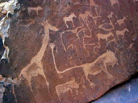
Three Engraving, Shelter, and Sandstone Details at Twyfelfontein
- Pecked Contrast Through Dark Desert Varnish: Kneeling beside a guided walkway slab, compare the dark brown iron-manganese patina covering undisturbed Mount Etjo boulder tops against the pale pecked interiors of giraffe legs and rhino horns. Chiselling just millimetres beneath that thin desert crust unlocked stark tonal contrast without requiring mineral paint.
- The Lion Man's Six-Toed Kinked Tail: Ask your conservancy guide to point out the famous Lion Man engraving, checking the animal's stretched rectangular tail bent sharply upward and finishing in human-like toes or a six-toed pugmark. That deliberate anatomical fusion captures San trance beliefs in which spiritual specialists crossed between human and feline form.
- Quartzite Tool Scars, Grinding Hollows, and Gong Stones: Beyond dramatic animal figures, look along flatter horizontal slabs for smooth circular seed-grinding depressions, rows of pecked game pits and resonant acoustic gong rocks that still link daily camp life around the jumping waterhole with sacred ceremony.
Kunene Temperatures and Overland Routes From Windhoek
Winter months around July offer cooler walking temperatures of 10 to 28 degrees Celsius compared with November highs of 35 degrees Celsius across unshaded sandstone boulders. Average annual rainfall stays below 150 millimetres across this semi-desert and savanna transition. Book early morning guided walks from the reception centre, when low sunlight throws shallow quartzite-pecked grooves across all 212 slabs into crisp relief before midday glare flattens contrast. Pair your circuit of engraved animal friezes, six ochre-painted shelters and acoustic gong rocks with nearby Organ Pipes, Burnt Mountain, Doros crater and Petrified Forest stops. Then follow road D3214 back to the C39 highway and drive southeast to Windhoek (354 kilometres away), or browse southern African rock art landscapes in the UNESCO World Heritage Atlas.