


























Quick Field Data
- UNESCO Inscription: 1987 (Cultural, Criterion iv; placed on the List of World Heritage in Danger from 1988 to 2004, reopened in 2012).
- Scale & Footprint: Monumental mud-brick citadel (comprising Al-Qasabah, Bait al-Hadith, and Bait Al-Jabal) accompanied by the Friday Mosque, historic harat residential compounds, semi-covered souq, palm grove, falaj irrigation channels, and an outer defensive wall (sur) spanning roughly 13 km.
- Access & Ticketing: Restored fortress complex open to visitors; because onsite exhibits, brochures, and guides are minimal, check the official site for visiting schedules and consider arranging a guided tour in advance.
- Arrival Logistics: Located at 22.9642°N, 57.3011°E in the oasis town of Bahla beneath the Jebel Akhdar mountain range in the interior of Oman.
Capital of the Banu Nebhan and Centre of the Omani Ibadi Imamate
Rising atop a rocky outcrop at 22.9642 degrees north and 57.3011 degrees east beneath the Jebel Akhdar mountain range in the interior of Oman, Bahla Fort (known in Arabic as Qalʿat Bahlāʿ) is one among four historic Omani fortresses positioned below the Jebel Akhdar highlands. Inscribed in 1987 as Oman's first World Heritage site, and followed one year later in 1988 by the Omani bronze-age monuments of Bat, Al-Ayn, and Al-Khutm, the mud-walled desert oasis and its immense fortress owe their medieval prosperity to the Banu Nebhan tribe (the Nabahina). Between the 12th century and the end of the 15th century, the Banu Nebhan dominated the central Omani region, establishing Bahla as their capital, controlling the lucrative trade in frankincense, and forging political relationships with other tribal groups across the Omani interior.
Alongside its political role as the stronghold of the Banu Nebhan ruling elite, Bahla functioned for centuries as the intellectual and spiritual centre of Ibadism, the branch of Islam upon which the ancient Omani Imamates were founded and whose theological and political influence extended across Arabia, East Africa, and the wider region. Following the era of the Banu Nebhan at the close of the 15th century, the strategic citadel was expanded by subsequent Omani rulers, including the Ya’riba dynasty between 1624 and 1743 and 18th-century builders who erected additional residential and defensive structures inside the fortress perimeter.
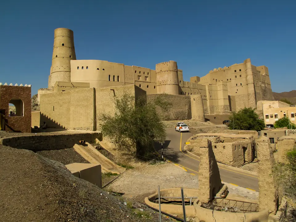
Built in a pre-gunpowder architectural style characterised by towering unbaked mud-brick walls, rounded watchtowers, and castellated parapets set on stone foundations, Bahla Fort was never an isolated military outpost. Instead, the fortress formed the governing nucleus of an integrated medieval Islamic fortified oasis settlement, binding together the citadel, the adjacent Friday Mosque, the semi-covered souq, the vernacular mud-brick residential quarters, the date-palm grove, the subterranean falaj irrigation network, and the 13-kilometre outer defensive wall into a single hydraulic and defensive system that attested to the power and status of the ruling elite.
Al-Qasabah, Bait al-Hadith, the 13-Kilometre Sur, and the Falaj Network
Constructed of unbaked bricks made of mud and straw laid over stone foundations and finished with mud mortar and plaster, the interior of Bahla Fort is organised around three main structural sectors spanning six centuries of Omani building tradition. At the highest point of the rocky outcrop stands Al-Qasabah, the oldest medieval citadel section dating to the Banu Nebhan period between the 12th and 15th centuries, rising several storeys above the surrounding oasis. Stretching across the enclosure is Bait al-Hadith, or the "New House", erected by the Ya’riba dynasty between 1624 and 1743 to expand the administrative and residential quarters of the fortress, while the third major wing, Bait Al-Jabal, was added during the 18th century, complemented by the dwellings of the fort guards (askari), deep interior wells, courtyards, and mosque chambers. Because its towering mud-brick walls, rounded watchtowers, and castellated parapets were conceived prior to the widespread introduction of gunpowder artillery, the citadel relies on height, thick earthen masonry, and commanding sightlines over the oasis.
Immediately adjacent to the fortress stands the historic Friday Mosque, which dominates the surrounding mud-brick settlement alongside the fort and is celebrated for its decoratively sculpted prayer niche (mihrab). Directly below the rocky outcrop of the fort lies the old semi-covered market (souq), formed by a walled complex of single-storey shops lining narrow shaded lanes; its position placed commercial life within easy visual surveillance from the fort above while linking the citadel to the artisanal and agricultural economy of the oasis. Surrounding the citadel, mosque, and souq is a labyrinth of traditional vernacular mud-brick family compounds (harats), including al-Aqr, al-Ghuzeili, and al-Hawulya, together with their associated neighbourhood mosques, communal audience halls (sablas), and bath houses. Although a large portion of the wider mud-brick oasis lies in ruins today, the principal structures and historic houses still stand across the settlement, surrounded by local legends associated with the castle and oasis and illustrating the social hierarchy of a late medieval Arabian tribal capital.
Enclosing the entire labyrinth of mud-brick dwellings, palm groves, and cultivatable land is an extensive outer perimeter wall known as the sur. Spanning roughly 13 kilometres (part of which remains standing around the oasis) and constructed using stone and mud-brick technology, the perimeter sur features a sentry walk, watchtowers, and several guarded gateways designed to control entry into the agricultural and residential core. Sustaining agriculture and domestic life across the settlement is the ancient Omani falaj irrigation system: an engineered network of mother wells and subterranean channels drawing groundwater from distant mountain springs and managing the seasonal flow of surface water, which directly determined the settlement pattern of the harats, bath houses, mosques, and palm groves across the desert floor. Together, the citadel on its rocky outcrop, the sculpted mihrab of the Friday Mosque, the single-storey lanes of the souq, the family compounds, the falaj channels, and the 13-kilometre sur demonstrate how medieval Omani builders engineered a self-sustaining fortified oasis beneath the Jebel Akhdar mountains.
Earthen Conservation, Danger Listing (1988 to 2004), and Field Exploration
Because unfired bricks of mud and straw decay rapidly when exposed to erosion and poor drainage, much of the oasis had fallen into ruin by the time Bahla Fort was inscribed on the UNESCO World Heritage List in 1987, leading to its placement on the List of World Heritage in Danger from 1988 to 2004. An early preservation attempt in 1995 was criticised as a renovation rather than a restoration because its aim was to make the fort look brand new; work started without preliminary archaeological, topographic, architectural, or technical surveys and applied heavy layers of stone and modern cement across the historic earthen surfaces, obscuring the original mud-brick, mortar, and plaster brickwork beneath. Subsequent rehabilitation efforts returned to authentic earthen materials, allowing UNESCO to remove Bahla Fort from the Danger List in 2004 (alongside Angkor) before the restored fortress reopened in 2012. In 2013, Professor Soumyen Bandyopadhyay and the ArCHIAM Centre prepared a comprehensive heritage management plan for Bahla Fort and its neighbouring oasis to address ongoing conservation risks, including the decay of unfired brick, bad drainage, the use of modern materials in rebuilding the souq (souk), the lack of recent conservation on the falaj irrigation network, and nearby building construction that destroyed or altered parts of the ancient perimeter wall. Because there are no onsite exhibits, brochures, or guides at hand to explain this vast space, visitors must either join an organised tour or explore independently. You can locate the Jebel Akhdar oasis on our interactive world map. Sun-baked earthen towers dominate the skyline.
- Climbing from Bait al-Hadith to the medieval Al-Qasabah tower: Enter the restored fortress complex (reopened in 2012) to explore the rooms of Bait al-Hadith (built by the Ya’riba dynasty between 1624 and 1743) and 18th-century Bait Al-Jabal alongside the guard dwellings (askari), rounded watchtowers, and castellated parapets before ascending to the oldest Banu Nebhan citadel of Al-Qasabah.
- Inspecting the Friday Mosque mihrab and the old souq: Walk beneath the rocky outcrop of the fort to view the adjacent Friday Mosque with its sculpted prayer niche (mihrab), then explore the single-storey shops and narrow lanes of the walled semi-covered souq and the vernacular mud-brick compounds of harat al-Aqr, al-Ghuzeili, and al-Hawulya with their communal sablas and bath houses.
- Tracing the falaj channels and the 13-kilometre perimeter sur: Follow the underground and surface channels of the falaj water system through the palm grove and cultivatable land toward the surviving stretches, sentry walk, gateways, and watchtowers of the 13-kilometre stone and mud-brick sur.
