


























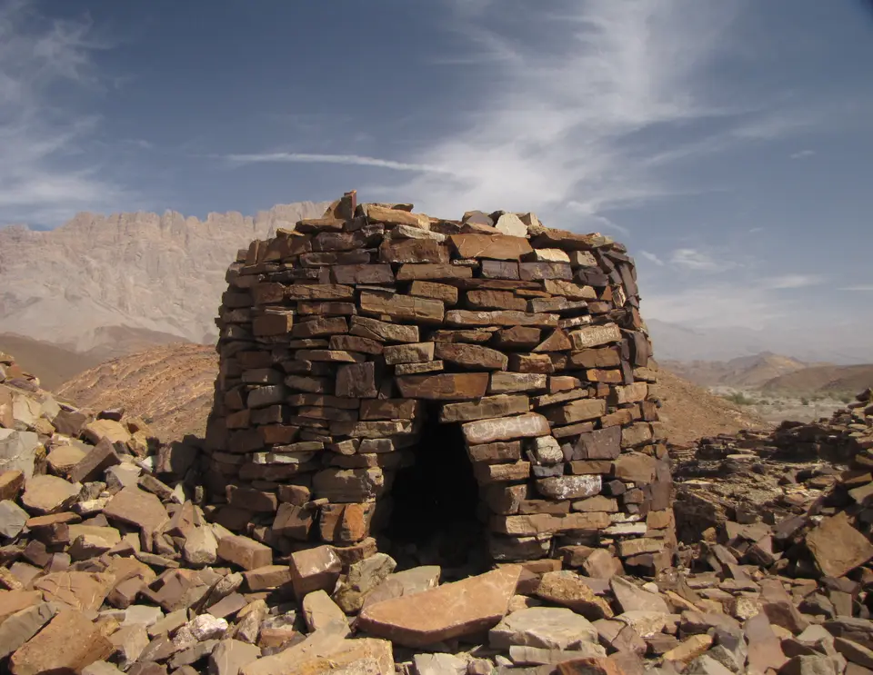
Quick Field Data
- UNESCO Inscription: 1988 under cultural criteria iii and iv as Oman's second World Heritage site (following Bahla Fort in 1987).
- Scale & Footprint: Three serial Bronze Age complexes in the Al-Dhahira Governorate: Bat (24 km east of Ibri), Al-Khutm (2 km west of Bat), and Al-Ayn (22 km southeast of Bat).
- Access & Ticketing: Open desert archaeological landscapes set near rural villages and date-palm groves; check official Omani heritage portals for visitor access rules.
- Arrival Logistics: Reached via regional roads from the town of Ibri (24 kilometres west of Bat) along the western foothills of the Hajar Mountains in northwestern Oman.
Spread across gravel terraces and date-palm groves in northwestern Oman's Al-Dhahira Governorate, the protohistoric complexes of Bat, Al-Khutm, and Al-Ayn form one of the world's most complete and best-preserved ensembles of 3rd-millennium BC settlements and necropolises. After 1988, the UNESCO World Heritage Atlas in 1988 under criteria iii and iv, becoming only the second Omani site inscribed after Bahla Fort was designated in 1987, the serial complex lies in the Wadi Sharsah basin roughly 24 kilometres east of Ibri town. Together, its monumental circular stone towers, prehistoric rural settlements, agricultural irrigation systems, and stone necropolises sit embedded inside a fossilised Bronze Age landscape against the backdrop of the Hajar Mountains. Ancient stone cairns line the ridges.
Copper Trade with the Sumerians and 4,000 Years of Oasis Habitation
Archaeological studies carried out over recent decades have documented numerous prehistoric human settlements stretching across the peninsula between the Persian Gulf and the Gulf of Oman. Positioned inside a lush palm grove along Wadi Sharsah, the core settlement of Bat flourished around 3000 BC at the height of an intensive regional trade in locally extracted copper and dark stone (probably diorite) exported to the Sumerians. Archaeological excavations conducted at Bat in 1972 by Danish archaeologists under the direction of Karen Frifelt demonstrated that the area had been continuously inhabited for 4,000 years, with later research published by scholars Christopher P. Thornton, Charlotte M. Cable, and Gregory L. Possehl in 2016 further detailing the Bronze Age towers at Bat.
Across the three serial locations, archaeologists trace a continuous architectural evolution through the 3rd millennium BC, moving from the early Hafit period into the Early and Late Umm an-Nar culture (down to roughly 2200 to 2000 BC) and linking them culturally with regional Bronze Age horizons such as Jabal Hafit, Hili Archaeological Park, Bidaa Bint Saud, Rumailah, Al-Buraimi, and Wadi Al Helo. Because the sites were never subjected to modern urban redevelopment or invasive reconstruction prior to UNESCO protection, their geographic isolation preserved the spatial relationship between working palm-grove settlements, hydraulic infrastructure, and burial grounds. Visitors walking the wadi terraces today can still see how prehistoric farmers channelled seasonal mountain runoff to irrigate crops while raising stone monuments on the surrounding rocky spurs.
Eight Circular Bronze Age Towers at Bat and Al-Khutm
A defining architectural feature of the complex is the monumental circular Bronze Age tower. Seven monumental stone towers have been discovered inside the core area of Bat, and an eighth stone tower stands at the extension site of Al-Khutm, situated 2 kilometres (or 1.2 miles) west of the Bat palm grove.
Constructed from dressed blocks of local limestone laid carefully in courses with simple mud mortar, each tower features a circular outer wall measuring roughly 20 to 25 metres (about 66 feet) in diameter. Inside the outer ring, two rows of parallel stone compartments flank a central well. Because these circular stone structures have no outside ground-level openings, scholars have proposed several interpretations of their precise function: besides a possible ritualistic role, they may have been used as water tanks or storage silos, stone forts, or solid platforms on which superstructures (now missing, such as houses or temples) were originally built.
Within the chronological sequence at Bat, the earliest known example is a mud-brick Hafit-period structure discovered directly beneath Matariya's Early Umm an-Nar circular stone tower. At the opposite end of the Bronze Age timeline stands Kasr al-Rojoom, which ceramic evidence dates to the Late Umm an-Nar period between roughly 2200 and 2000 BC. Two kilometres west of Bat, the ruins at Al-Khutm preserve a stone fort complex centred on a rock-built circular tower measuring 20 metres (66 feet) in diameter, demonstrating how monumental tower architecture guarded the wadi approaches outside the main palm grove. Comparing the seven towers at Bat with the western outpost at Al-Khutm reveals how standardized the 20-to-25-metre circular plan had become across the Wadi Sharsah basin during the 3rd millennium BC.
- The Core Settlement of Bat: Located inside a palm grove in Wadi Sharsah roughly 24 kilometres east of Ibri, uniting seven monumental towers (including the Hafit mud-brick and Early Umm an-Nar stone phases at Matariya and the Late Umm an-Nar tower of Kasr al-Rojoom), rural settlements, irrigation channels, and a vast necropolis of 100 graves.
- The Stone Tower of Al-Khutm: Situated 2 kilometres (or 1.2 miles) west of the Bat palm grove, featuring a 20-metre-diameter rock tower and associated stone fort ruins guarding the western approach to the palm grove.
- The Beehive Necropolis of Al-Ayn: Set 22 kilometres (14 miles) to the southeast of Bat, comprising a compact group of Hafit-period beehive burial mounds preserved in the best structural condition of the three necropolises against the Hajar Mountains.
Two Necropolis Groups and the Beehive Tombs of Al-Ayn
North of the settlement zone at Bat extends a vast Bronze Age necropolis containing 100 graves and circular buildings, with circular structures measuring about 20 metres (66 feet) in diameter. The monumental tombs at Bat are divided into two distinct morphological groups that reflect the transition from the single-chambered dry-stone cairns of the Hafit period in the early 3rd millennium BC to the larger, finely dressed multi-chambered circular tombs of the Umm an-Nar period. Walking between the two sectors at Bat allows visitors to see how dry-laid rough stone cairns on the upper slopes gave way to precision-cut white limestone masonry on the lower wadi terraces.
Twenty-two kilometres (14 miles) southeast of Bat lies the third component of the World Heritage listing: Al-Ayn. Although smaller in size than the burial fields of Bat, the necropolis at Al-Ayn stands in the finest state of preservation among all three sites. Set along a rocky crest with the dramatic peaks of the Hajar Mountains rising in the background, its row of dry-stone Hafit beehive tombs illustrates the stone-corbelling skills of 3rd-millennium BC builders. Historically, because the sites had not undergone conservation or restoration before UNESCO inscription, isolation served as their primary shield, while the greatest threat to preservation came from local builders taking stone material from the archaeological ruins for village construction.
Desert Road Connections and Field Orientation
Exploring the three serial sites works best as a full-day circuit by vehicle from Ibri, located 24 kilometres west of Bat in the Al-Dhahira region. Start in the morning at the modern village and palm grove of Bat to walk among the seven circular towers, comparing the stratified mud-brick and limestone masonry at Matariya with the massive dressed limestone ring of Kasr al-Rojoom, before continuing into the northern necropolis to examine the two distinct tomb groups and ancient irrigation channels. Next, drive 2 kilometres west from Bat to inspect the 20-metre stone tower at Al-Khutm, and then follow the wadi road 22 kilometres southeast to reach Al-Ayn in the late afternoon, when low sunlight highlights the beehive burial mounds against the Hajar Mountains. Regional connectivity across Al-Dhahira expanded in September 2021 with the completion of a 700-to-800-kilometre (430-to-500-mile) desert highway linking Ibri in Oman with Al-Ahsa in eastern Saudi Arabia, comprising an approximately 160-kilometre (99-mile) Omani section and a 580-kilometre (360-mile) Saudi section. You can trace all three Bronze Age locations on the Atlas.
Plan your visit during the cooler months between October and March, carry plenty of drinking water for the exposed gravel ridges, wear sturdy footwear, and avoid climbing on or displacing the fragile dry-stone walls of the beehive graves and towers.
Examining the spatial distribution of the three serial sites across the Wadi Sharsah basin and its neighbouring valleys clarifies how Bronze Age communities managed scarce desert resources over four millennia. At Bat, the close alignment of the seven circular limestone towers with ancient irrigation channels and domestic foundations shows that monumental construction was directly tied to the protection and distribution of seasonal wadi water inside the palm grove. Meanwhile, the transition from the single-chambered Hafit beehive cairns on the dry upper ridges, seen in their finest state of preservation along the mountain spur at Al-Ayn, to the larger, finely dressed multi-chambered Umm an-Nar collective tombs on the lower terraces documents the growing social complexity of 3rd-millennium BC oasis life in interior Oman.
