Quick Field Data
- UNESCO Inscription: 2006 (Ref. 1229), serial cultural monument in Homs and Latakieh governorates, Syrian Arab Republic; Criteria (ii) and (iv).
- Scale & Footprint: 8.87 hectares across two elevated mountain strongholds: Crac des Chevaliers overlooking the Homs Gap and Qal'at Salah El-Din east of Latakieh.
- Access & Ticketing: Protected under Syrian Antiquities Law No. 222 (revised 1999) and administered by the Directorate of Antiquities and Museums (DGAM) with local committees; check official government travel advisories before any trip.
- Arrival Logistics: Damascus International Airport (DAM) lies 199 kilometres south, while regional Mediterranean flights serve Adana (217 kilometres northwest in Turkey).
Strategic Hilltops Guarding the Homs Gap and Coastal Passes
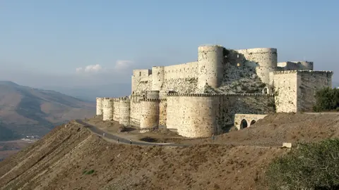
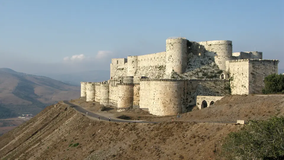
Commanding steep limestone ridges above western Syria, Crac des Chevaliers and Qal'at Salah El-Din preserve two of medieval military engineering's most formidable hill fortresses. Inscribed jointly in 2006 across 8.87 hectares, the pair anchors southern and northern flanks of the Syrian Coastal Mountain Range (Jibal al-Alawiyin). Crac des Chevaliers crowns a 650-metre-high hill east of Tartus and 40 kilometres west of Homs in the fertile, rain-fed Homs Gap linking Tripoli and Homs near Lebanon. Unlike the Kingdom of Jerusalem's drier estates, Tripoli's limestone ridges yielded strong natural defensive sites guarding productive valleys fed by perennial streams. Further north in Latakieh Governorate, Qal'at Salah El-Din commands an isolated rocky spur retaining successive defensive masonry from 10th-century Byzantium through Ayyubid rule.
Known in Arabic as Qal'at al-Ḥiṣn and earlier as Ḥiṣn al-Safḥ or Ḥoṣn al-Akrād (Fortress of the Kurds), the southern hill pre-dates the First Crusade. According to 13th-century Arab historian Ibn Shaddad, Mirdasid emir Shibl ad-Dawla Nasr settled Kurdish tribesmen on the ridge in 1031 to restore access toward Tripoli after losing nearby Gibelacar (27 kilometres across the Homs Gap) to Fatimid forces in 1029. Advancing Crusaders under Raymond IV of Toulouse skirmished with the garrison in January 1099 after foragers came under attack, occupying the deserted ridge briefly in February before marching south toward Jerusalem. Permanent Crusader occupation arrived in 1110 under Tancred, Prince of Galilee, though no structural masonry trace survives from that earliest stronghold.
Between 1142 and 1144, Count Raymond II of Tripoli ceded Crac and four border castles to the Knights Hospitaller, forming what historian Jonathan Riley-Smith described as an effective border palatinate. Originating around the 1070s in Jerusalem to tend sick pilgrims before militarising in the 1130s when King Fulk granted Beth Gibelin, the order assumed wide authority over Rafanea, Montferrand and the Beqa'a plain backed by papal bulls from 1139 to 1143. Under Raymond's pact, the Hospitallers kept full spoils when campaigning alone, shared equally when the count joined them and held veto power over peace treaties with Muslim rulers. Crusaders speaking Old French or Old Occitan turned Arabic Ḥoṣn al-Akrād into Le Crat and Le Crac (confused with Classical Syriac karəḵā, walled city), called it Crac de l'Ospital and saw 19th-century writers romanticise the name into Krak des Chevaliers, meaning Fortress of the Knights.
Concentric Crusader Masonry and Qal'at Salah El-Din Stratigraphy
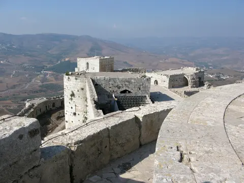
Studying the Krak des Chevaliers layout and floor plan shows how Hospitaller masons countered siege warfare and regional earthquakes across two major building phases. During the first phase from 1142 to 1170, builders raised an enclosing stone circuit that later formed the inner court while Crusader troops defeated Nur ad-Din nearby at the 1163 Battle of al-Buqaia. After a severe 1170 earthquake ruined the earliest chapel, Arab chronicles note that architects built the extant barrel-vaulted chapel inside the inner ward. Droughts from 1175 to 1180 forced a two-year truce excluding Tripoli, and in 1180 Saladin ravaged surrounding Tripoli farmlands while knights sheltered securely inside their stone fortresses, regaining control once Muslim forces withdrew.
Disastrous Crusader defeat at the 1187 Battle of Hattin cost King Guy of Lusignan, the True Cross and Hospitaller castles at Belmont, Belvoir and Bethgibelin after Saladin executed captured knights. That collapse forced the Hospitaller Order to focus defences around County of Tripoli fortresses, and when Saladin marched up to Krak des Chevaliers in May 1188, he judged its walls too strong and turned toward Margat instead, which he likewise failed to take. Following a second severe earthquake in 1202, 13th-century builders wrapped the taller 1142 to 1170 inner ward with an outer curtain studded with semicircular towers and separated by a wide southern pool, leaving zero trace of any earlier outer circuit. Because inner ramparts towered above the lower outer ring, Krak's early 13th-century golden age maintained a standing garrison around 2,000 soldiers collecting tribute and launching raids toward nearby Muslim-held Homs, surviving as the only major inland Crusader principality until 1271.
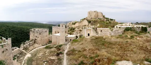
Northward near Latakieh, Qal'at Salah El-Din (Fortress of Saladin) displays clear archaeological stratigraphy despite standing partly in ruins. Perched atop an isolated ridge severed from neighbouring plateaus by rock-cut ditches, its masonry retains three consecutive eras: 10th-century Byzantine citadel walls, late-12th-century Frankish towers and keeps, and late-12th-to-mid-13th-century Ayyubid additions built after Saladin's conquest. Unlike passive European castles anchored chiefly by thick central keeps, both Syrian fortresses demonstrate active flanking fire systems that subsequently reshaped castle engineering across Europe and the Levant.
Mamluk Sieges, Modern Clearance, and Post-2014 Conservation
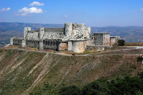
Hospitaller supremacy across the Homs Gap finally ended in 1271 after dwindling regional resources from the 1250s left inland strongholds isolated from coastal ports. Following a focused 36-day siege, Mamluk Sultanate armies captured Crac des Chevaliers when defenders accepted surrender terms, supposedly persuaded by a forged letter bearing the Hospitallers' Grand Master seal. Mamluk rulers swiftly strengthened damaged sections and built massive late-13th-century rectangular defensive towers across the southern approach, leaving unmistakable Islamic military masonry integrated with Frankish vaults.
Modern heritage policy diverged sharply between the two citadels during the 20th century. During the late 19th and early 20th centuries, European architects surveyed Krak des Chevaliers and drafted measured plans while a village settlement grew inside the castle fabric. In 1933, French Alawite State authorities relocated roughly 500 local villagers, cleared deep soil deposits and executed targeted restoration before independent Syria took charge in 1946. Conversely, remote Qal'at Salah El-Din saw little later alteration, and following an imitative 1936 restoration of its Ayyubid palace gate, conservators abandoned conjectural rebuilding in favour of strict archaeological consolidation.
Twenty-first-century conflict inflicted fresh physical damage on Krak des Chevaliers before urgent conservation resumed. Shelling during the Syrian civil war damaged parts of the stonework before government forces regained control in 2014, launching structural repairs and Krak des Chevaliers reconstruction monitored annually by UNESCO and the Directorate of Antiquities and Museums (DGAM). Syrian Antiquities Law 222 (revised 1999) and Ministry of Local Administration Law 15/1971 govern conservation across both sites with annual DGAM maintenance budgets. Local management links al-Husn village (population nearly 9,000) and regional Latakieh authorities under a planned Castles of Syria administrative framework. Authorities also target illegal modern houses, restaurants and hotels near the castles while rejecting intrusive cable-car and open-air theatre schemes, especially along Crac's vulnerable eastern slopes.
Access Zones Across Krak des Chevaliers and Qal'at Salah El-Din
Evaluating the Krak des Chevaliers floor plan together with Qal'at Salah El-Din clarifies how outer concentric rings guard interior vaulted halls and open ruins. Always confirm current regional security conditions and official national government travel advisories before planning any journey to either Syrian ridge.
| Complex Zone | Key Highlights | Access & Ticket Rule |
|---|---|---|
| Krak Outer Concentric Circuit | 13th-century curtain walls, rounded flanking towers, Mamluk southern bastion repairs and vaulted entry ramp. | Administered locally by DGAM and al-Husn authorities; verify site opening status and safety conditions before arrival. |
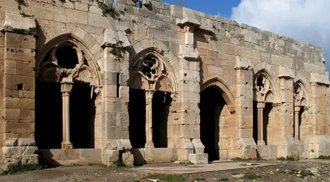
| Krak Inner Court, Chapel, and Hall | 1142 to 1170 core ward, sloping southern glacis, vaulted Gothic Hall of the Knights and painted Crusader chapel. | Interior vaulted halls require careful footing over worn medieval cobbles; respect active post-2014 repair barriers. |
| Qal'at Salah El-Din Ridge | 10th-century Byzantine keep traces, deep rock-cut ditch, Frankish towers and 1936-restored Ayyubid palace gate. | Isolated partly ruined archaeological site managed via DGAM Latakieh; check steep ridge paths and conservation cordons. |
Three Military Engineering Details Across Both Fortresses
- Sloping Masonry Talus on the Inner Southern Wall: Look across the open water pool between Krak's two curtain rings to view the steep stone glacis built to deflect siege rams and seismic tremors.
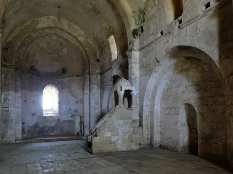
- Vaulted Arcade of the Hall of the Knights: Step inside Krak's inner courtyard loggia to inspect crisp Gothic ribbed vaulting and carved stone tracery added during the Hospitallers' early 13th-century golden age.
- Stratified Stone Masonry at Qal'at Salah El-Din: Compare coarse 10th-century Byzantine wall blocks with massive Frankish ramparts and later Ayyubid palace arches across the northern castle ridge.
Travel Advisories, Historic Routes, and Regional Context
Every traveller researching Krak des Chevaliers Syria reviews or historic Levantine itineraries must consult official national government travel advisories carefully before considering overland travel. Security conditions, road checkpoints and site access fluctuate rapidly across western Syria, making verified official guidance essential before booking routes into Homs Governorate or Latakieh. For geographic context, Damascus International Airport (DAM) lies 199 kilometres south as Syria's principal international gateway, while Mediterranean regional hubs across southern Turkey lie 217 kilometres northwest at Adana. Local roads also cross fertile agricultural valleys linking Homs, Tartus and northern Lebanon across the Homs Gap where stream-fed ridges made medieval settlement prosperous.
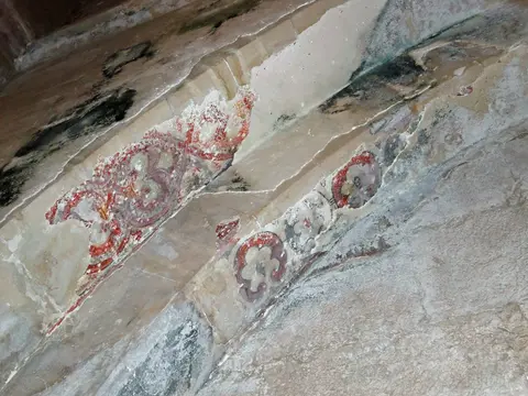
Architecturally, comparing Krak des Chevaliers interior plans, vaulted horse ramps and painted chapel remnants with Qal'at Salah El-Din shows why military historians treat both strongholds as one continuous textbook. Entering Krak's vaulted approach ramp beneath arrow slits before emerging into the open inner court reveals how 2,000 soldiers lived, stabled horses and stored rainwater behind concentric stone walls. Meanwhile, Qal'at Salah El-Din exposes raw archaeological cross-sections across steep coastal gorges where Byzantine, Frankish and Ayyubid masons successively cut defences straight into living bedrock. Studying Krak des Chevaliers photos and Guillaume Rey's 19th-century survey plans side by side highlights how complete the inner courtyard arcades remain despite centuries of earthquakes and conflict.
Viewing both castles within the fertile Homs Gap and County of Tripoli geography explains every engineering choice preserved in stone. Guarding crucial farm valleys and caravan roads linking Homs, Tartus and Tripoli turned remote limestone ridges into self-contained military towns that withstood earthquakes and armies alike across centuries. Both strongholds preserve rare physical continuity linking 11th-century Kurdish garrisons, 12th-century Frankish builders, 13th-century Ayyubid rulers and Mamluk engineers across western Syria.
Walking through historical architectural records further illustrates how distinct local conditions shaped both hilltop compounds. At Krak des Chevaliers, fertile plains fed by abundant rains and local streams sustained large Hospitaller garrisons and administrative offices, yet closeness to rival Homs forced knights to watch eastern approaches continually for raids across the 27-kilometre gap toward Gibelacar. Below the fortress walls today spreads the modern village of al-Husn, whose hillside streets trace the outer perimeter. Reviewing classic medieval histories confirms that Krak dominated County of Tripoli defence networks across northern Lebanon and Syria for over a century. By contrast, remote Qal'at Salah El-Din perched deep inside northern mountain valleys near Latakieh stayed partly ruined and undisturbed for centuries, allowing archaeologists to inspect exposed 10th-century Byzantine masonry, Frankish rock-cut walls and Ayyubid palace foundations side by side. Explore additional fortified citadels and medieval monuments across the Middle East inside our UNESCO World Heritage Atlas.