


























Quick Field Data
- UNESCO Inscription: 1981 · Criteria (vii), (ix), (x)
- Scale & Footprint: 575,000 hectares (5,790 square kilometres) in Darién Province, southeastern Panama, embedded within an 859,333-hectare UNESCO Biosphere Reserve along 90 percent of the border with Colombia
- Access & Ticketing: Managed by Panama's environmental authority with strict wilderness entry controls; access centres on the ANAM ranger station at Pirre Station (which maintains basic dormitory accommodation and forest trails) and the remote Cana valley
- Arrival Logistics: Located roughly 325 kilometres southeast of Panama City inside the roadless Darién Gap, requiring overland and river transport to the western trailhead near Cerro Pirre or charter light-aircraft access into Santa Cruz de Cana
The Intercontinental Land Bridge and the Darién Gap
Covering 575,000 hectares (5,790 square kilometres) across Darién Province at the southeastern tip of Panama, Darién National Park (Parque Nacional Darién) forms the physical and biological land bridge connecting the two continents of North and South America. First protected in 1972 when 700,000 hectares (1,700,000 acres) were designated as the Alto Darién Protection Forest, the territory was officially declared a national park on 27 September 1980, inscribed on the World Heritage List in 1981 during the 5th session, and expanded into an 859,333-hectare (2,123,460-acre) UNESCO Biosphere Reserve in 1983. As the largest national park in Panama and one of the largest protected areas in Central America, its southern boundary stretches along 90 percent of the international frontier with neighbouring Colombia, where it adjoins Los Katíos National Park in Colombia, another World Heritage site, to create a contiguous transboundary wilderness corridor across the isthmus.
Geographically, the park is framed between two distinct maritime and mountain boundaries in southeastern Panama. To the northeast, the Serranía del Darién mountain range runs parallel to the Caribbean Sea just 16 kilometres (9.9 miles) inland, while to the southwest the reserve encompasses an unbroken stretch of the Pacific Ocean coastline. Between these boundaries, the terrain rises from sea-level sandy beaches and rocky shores through coastal mangroves and expansive freshwater swamps into the most extensive lowland tropical rainforest on the Pacific Coast of Central America. Above the lowland canopy, steep forested ridges and palm forests climb into premontane and montane cloud forests on the summit of Cerro Tacarcuna at 1,875 metres above sea level and across the isolated massif of Cerro Pirre. Isolation defines every valley here.
Because this rugged topography of river basins and tidal wetlands alongside creeks, palm forests, and serrated mountain ridges has resisted modern highway engineering, the park forms the geographic core of the roadless Darién Gap, which interrupts the Pan-American Highway between Argentina and Alaska. Situated approximately 325 kilometres (202 miles) southeast of Panama City, this complete absence of through-roads has shielded the lowland and upland forests from the agricultural clearing and habitat fragmentation seen elsewhere in Central America. Consequently, evolutionary processes and species exchanges between North and South America continue uninterrupted across the 5,790 square kilometres (2,240 square miles) of protected wilderness, preserving an intact ecological gradient that spans coastal beaches, mangrove estuaries, freshwater marshes, lowland tropical rainforests, and high-elevation cloud forests along the Serranía del Darién and Cerro Tacarcuna.
Endemic Cloud Forests, Threatened Fauna, and Indigenous Territories
Unlike strict wilderness reserves that exclude human communities, Darién National Park was groundbreaking in explicitly integrating a cultural and ethnic dimension into conservation planning across the reserve. Major archaeological findings across the river valleys attest to centuries of pre-Columbian human settlement along this intercontinental land bridge between North and South America. Today, the park remains one of the few examples globally of a national park inhabited by living communities, serving as the ancestral homeland of indigenous peoples of the Embera alongside the Wounaan and Kuna tribes, as well as Afro-descendants who inhabit the riverbanks and coastal margins. Traditional settlement and river navigation patterns coexist with the primary rainforest, making cultural stewardship a foundational element of the park's conservation model and supporting ongoing biological and ethnographic research across the 575,000-hectare national park and the surrounding 859,333-hectare UNESCO Biosphere Reserve. This dual focus on cultural continuity and biological protection across the Darién Province ensures that the forest corridors between the Pacific Ocean and the Serranía del Darién remain intact for future generations of researchers and indigenous communities alike.
Across the altitudinal gradient from the Pacific littoral to the 1,875-metre crest of Cerro Tacarcuna and the cloud-draped slopes of Cerro Pirre, biological surveys have documented hundreds of vertebrates and thousands of invertebrates, with high local endemism across isolated mountain ridges and river basins. Among the 169 documented species of mammals are several of the most threatened large vertebrates in the New World: the critically endangered brown-headed spider monkey alongside the endangered Central American tapir and the vulnerable giant anteater. Large carnivores and herd ungulates, including the near-threatened jaguar alongside the bush dog and the white-lipped peccary, require vast, unfragmented territories to survive; the unbroken forest link between Darién National Park and adjacent Los Katíos National Park in Colombia provides the continuous canopy and prey base necessary to sustain viable breeding populations alongside several types of monkeys and sloths.
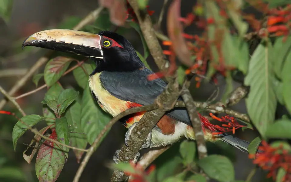
Avian diversity is equally dense across the mangroves and wetlands alongside palm forests and montane ridges, prompting BirdLife International to designate the reserve as an Important Bird Area (IBA). More than 530 recorded species of birds inhabit the park's coastal and mountain ecosystems. Flagship threatened birds include the endangered great green macaw alongside the vulnerable great curassow, the collared aracari, and a major breeding population of the near-threatened harpy eagle, which nests in tall emergent trees across the undisturbed lowland rainforest.
Two historic field stations on opposite flanks of Cerro Pirre anchor scientific research and ranger patrols alongside ecological monitoring within the interior of the park. Located in the central interior near the eastern slope of Cerro Pirre lies Santa Cruz de Cana (known simply as Cana), a remote mountain-ringed valley recognised as one of the world's ten greatest birdwatching spots, equipped with a ranger station and forest trail network. On the opposite, western side of Cerro Pirre stands Pirre Station, an ANAM ranger station surrounded by primary forests where footpaths climb directly into the habitats of monkeys and sloths alongside highland bird species.
Field Logistics for Entering Pirre Station and Santa Cruz de Cana
Due to its extreme isolation inside the roadless Darién Gap along the Colombia border, Darién National Park is one of the least accessible World Heritage sites in the Americas. Independent travel into the interior requires advance permits alongside experienced local guides and careful attention to seasonal weather and border safety conditions. Visitors cannot drive into the core wilderness; instead, all field visits focus on the two established stations on either side of Cerro Pirre, where foot trails explore the transition from lowland rainforest to steep montane slopes.
Organise your expedition around the two authorised access points and seasonal trail conditions.
- Hike into Pirre Station on the western slope of Cerro Pirre: For travellers approaching overland from Panama City (325 kilometres away), the primary entry point is Pirre Station, the ANAM ranger station situated on the western side of Cerro Pirre. Visitors trek in along forest paths to reach the ranger station, which provides basic dormitory accommodation where travellers can stay overnight and hike several trails leading directly into primary rainforest inhabited by sloths alongside brown-headed spider monkeys, Central American tapirs, and harpy eagles.
- Access Santa Cruz de Cana for eastern slope birdwatching: The second point of access is Santa Cruz de Cana, located inside the central reserve near the eastern slope of Cerro Pirre. Celebrated among ornithologists as one of the world's ten greatest birdwatching spots, Cana features a ranger station and several trails traversing lowland and foothill habitats where visitors can search for the endangered great green macaw alongside the vulnerable great curassow and a high concentration of the park's 530 recorded bird species.
- Plan around dry months and transboundary conservation rules: Schedule hikes during the drier months when river crossings and steep clay trails on Cerro Pirre are most passable, and coordinate all entry permits and current border-zone advisories with Panama park authorities well in advance of departure. To compare this intercontinental land bridge with adjacent Los Katíos National Park or explore other tropical wilderness reserves, consult our UNESCO World Heritage Atlas.
