


























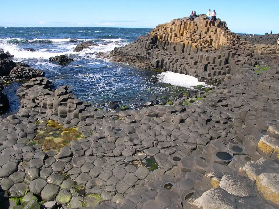
Quick Field Data
- UNESCO Inscription: 1986, inscribed for superlative coastal scenery and a classic textbook exposure of Tertiary basaltic volcanism.
- Scale & Footprint: Covers a 6-kilometre stretch of the County Antrim headland and sea cliffs alongside the foreshore along the north coast of Northern Ireland.
- Access & Ticketing: Public coastal footpaths run along the clifftops and foreshore, while the visitor facility near Bushmills manages parking and exhibitions alongside guided tours; check the official site for booking details.
- Arrival Logistics: Located approximately 3 miles northeast of Bushmills on the north coast of Northern Ireland, accessible via road and rail connections from Belfast and Dublin.
Along the storm-swept northern shoreline of County Antrim in Northern Ireland, the Giant's Causeway and Causeway Coast present one of the world's most celebrated exposures of columnar basalt geology. Within United Kingdom, the UNESCO World Heritage Atlas in 1986, the protected area encompasses rugged sea cliffs and wave-cut platforms alongside scree slopes stretching across a 6-kilometre coastal ribbon near the town of Bushmills. At the foot of the cliffs, roughly 40,000 interlocking polygonal stone columns step down from the headland like an engineered pavement before vanishing beneath the North Atlantic waves. Beyond its striking visual geometry, the coastline provides a continuous cross-section of Paleogene volcanic activity that helped shape modern geological science. Travellers journeying north from Dublin or Belfast encounter a dramatic maritime environment where folklore and earth history meet along sheer volcanic headlands. Atlantic rollers crash against the dark stone.
Paleogene Lava Plateaux, Laterite Horizons, and Polygonal Cooling Cracks
The rock formations exposed along the Causeway Coast originated between 50 and 60 million years ago in the Paleocene epoch, when the opening of the North Atlantic Ocean triggered intense fissure volcanism across the Thulean Plateau. Successive eruptions poured fluid tholeiitic basalt across an older terrain of white Cretaceous chalk, burying the region beneath a thick volcanic plateau. Geological stratigraphic analysis divides this Antrim Lava Group along the cliffs into three distinct eruptive phases: the Lower Basalts and Middle Basalts up to the Upper Basalts. During a prolonged quiescent interval between the Lower and Middle eruptive cycles, warm humid weather chemically weathered the exposed basalt surface for thousands of years, creating a vivid red laterite soil horizon up to 12 metres thick that cuts across the dark cliff face.
When volcanic activity resumed during the Middle Basalt phase, a massive flow of molten lava poured into a deep river valley that had eroded through the Lower Basalts and down toward the underlying chalk. Ponded to a great depth inside this ancient valley, the thick lava lake cooled slowly and uniformly from both top and bottom. As the solidifying rock contracted under thermal stress, horizontal tensile forces fractured the cooling mass into a tightly packed honeycomb of vertical columns. Although six-sided hexagonal pillars are the most common configuration, individual columns also exhibit four or five as well as seven or eight sides and measure between 15 and 30 inches in diameter, reaching heights of up to 25 metres in the cliff exposures and 12 metres along the foreshore causeway.
Subsequent glacial erosion during the Pleistocene ice ages and relentless wave action stripped away the softer surrounding valley walls, leaving the dense columnar infill protruding into the sea as three distinct low promontories extending into the surf. Across the coastal cliffs and bays, marine and subaerial erosion has sculpted distinctive structural features that bear evocative local names. These include the Giant's Organ, a towering tier of 60 vertical columns embedded in the cliff face that resembles cathedral organ pipes; the Chimney Stacks, eroded pillar remnants standing isolated on a high headland ridge; the Giant's Harp, where curved basalt columns bend gracefully toward the base of the lava flow; the Giant's Boot, a weathered vesicular boulder sitting beside the bay path; and the Giant's Eyes, reddish spheroidal weathering boulders exposed inside the dark basalt matrix.
Maritime Cliff Ecology, Gaelic Legend, and Early Earth Science
Because the coastal cliffs rise up to 100 metres above the sea and face prevailing Atlantic gales, the headland supports specialised maritime plant communities and seabird colonies adapted to salt spray and thin volcanic soils. Along the upper cliff ledges and basalt scree slopes as well as coastal grasslands, botanical surveys have recorded rich maritime flora including sea spleenwort and vernal squill alongside sea fescue and frog orchid. In 1987, the wider foreshore and cliff belt was additionally designated a National Nature Reserve, providing protected breeding and foraging habitat for fulmars and petrels alongside shags, guillemots, and razorbills that wheel above the surf.
Centuries before geologists deciphered the thermal mechanics of cooling lava, Gaelic oral tradition explained the geometric stone pavement through the legend of the mythical warrior Fionn mac Cumhaill, also called Finn MacCool. According to the tale, Fionn constructed the stone causeway across the North Channel to confront his Scottish rival Benandonner on the island of Staffa, where an identical Paleogene basalt exposure forms Fingal's Cave. When Fionn saw the immense size of his approaching foe, his wife disguised him as a sleeping infant inside a giant cradle; terrified at the thought of how large the father of such a child must be, Benandonner fled back to Scotland, tearing up the middle section of the stone roadway behind him so Fionn could not follow.
In the late seventeenth and eighteenth centuries, the Causeway Coast became a central focus in the scientific debate over how basaltic rocks formed in nature, pitting scholars who argued that basalt precipitated out of primordial oceans against those who proposed an igneous volcanic origin. Following early reports to the Royal Society and Susanna Drury's celebrated 1739 watercolour paintings of the cliffs, which were engraved and circulated across Europe, naturalists studied the interlocking basalt joints of County Antrim in detail. Field observations of the vesicular lava tops alongside baked red laterite contacts and columnar cooling patterns along these cliffs provided decisive empirical proof for the volcanic nature of basalt, cementing the site's global scientific reputation.
Navigating the Clifftop Paths and Foreshore Bays
Today, the main Causeway headland and its immediate coastal paths are cared for by the National Trust, which operates a low-profile visitor facility completed in 2012. Set into the green hillside above the cliffs and clad in vertical basalt mullions that echo the natural rock formations below, the building provides geological displays and coordinates visitor flow toward the foreshore. From the crest of the headland, a paved access road and parallel pedestrian footpath descend past the windy notch in the ridge into the sheltered bays below, delivering walkers directly onto the basalt stepping stones at the water's edge.
For travellers seeking broader perspectives of the stratigraphic layers, the clifftop trail continues eastward above the recessed bays and the natural rock Amphitheatre toward the eastern headlands. An intermediate lower path, historically known as the Shepherd's Steps route, climbs a steep staircase cut into the cliff wall between the foreshore bay and the upper grassland plateau. Walking both levels reveals how the horizontal red laterite band separates the older lower lava flows from the massive columnar tiers of the Middle Basalts above.
Along the entire length of the Causeway Coast, the alternating layers of dark columnar basalt alongside vesicular lava flows and bright red weathered laterite horizons provide an open geological archive of Paleogene volcanic activity. As Atlantic swells break against the stepped polygonal columns at the foot of the headlands, coastal erosion continues to expose fresh cross-sections of the ancient lava lake that once filled the river valley above the chalk bedrock. Walking both the upper clifftop grassland paths and the lower bay tracks allows visitors to observe how thermal contraction and marine weathering have shaped every headland and cove.
Observing coastal safety guidelines and timing your walk enhances the visit along the volcanic shore.
- Exercise caution on wet basalt columns: Sea spray and rain make the lower polygonal stones extremely slippery, and sudden Atlantic swells can sweep over the seaward edge of the causeway stones without warning.
- Combine the foreshore and clifftop routes: Walk out along the high clifftop path to view the red laterite bed and the Amphitheatre from above, then descend the Shepherd's Steps to return along the lower bay track past the Giant's Organ.
- Check trail maintenance advisories: Because natural rockfalls occasionally occur along the weathered basalt and laterite cliff faces, verify current trail access at the visitor desk before hiking along the eastern bays.
