Quick Field Data
- UNESCO Inscription: Cultural site inscribed in 2018 (Ref. 1572) under criteria (i), (ii), and (iv).
- Scale & Footprint: 126 hectares on a limestone plateau near Orencik in Sanliurfa Province, centred on an 8-hectare archaeological mound rising 15 metres high with at least 20 enclosures detected by geophysical survey.
- Access & Ticketing: Protected archaeological reserve reached via elevated wooden walkways under shelter canopies and an on-site visitor complex; original excavated reliefs and sculptures are housed at Sanliurfa Archaeology Museum, and travellers should check the official site for current entry procedures and shuttle schedules.
- Arrival Logistics: Gaziantep Oguzeli International Airport (GZT, 132 kilometres west) operates as the wider commercial air gateway, whereas Sanliurfa GAP Airport (GNY, 25 kilometres away) sits closer with more limited passenger routes; the provincial city of Sanliurfa lies 13 kilometres southwest.
Limestone Plateau Hydrology and the Germus Ridge Setting
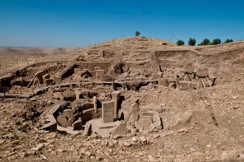
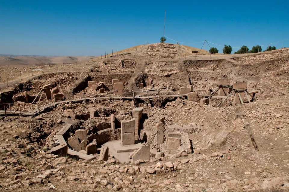
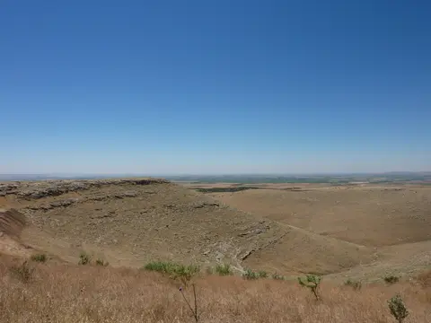
Rising on a flat limestone plateau in the Germus mountains of southeastern Turkiye, Gobekli Tepe sits in the Tas Tepeler hills near the village of Orencik. From this ridge in the foothills of the Taurus Mountains, the 15-metre-high artificial tell overlooks the broad Harran plain and the headwaters of the Balikh River, a northern tributary of the Euphrates. A narrow promontory links the hilltop to adjacent upland slopes on its northern flank, while steep limestone escarpments drop away in the other directions. That commanding elevation gave builders clear visual lines across the valley floor while keeping soft workable limestone and hard flint tool stone directly underfoot.
During the Pre-Pottery Neolithic occupation between roughly 9500 BCE and at least 8000 BCE, the local environment held substantially more moisture than the arid steppe seen around Sanliurfa today. Archaeobotanical charcoal samples consist 90 percent of pistachio and almond wood, pointing to open steppe grassland dotted with nut trees rather than dense timber forest. Wild einkorn, wheat, and barley grew across the surrounding slopes, supporting migratory herds of goitered gazelle with wild sheep, wild goats, and equids. Archaeozoological bone assemblages point to large-scale seasonal hunting of gazelle between midsummer and autumn, paired with stone grinding tools, mortars, and pestles used to process harvested cereals on site.
Sustaining large seasonal or year-round gatherings on an elevated limestone ridge required deliberate water engineering. Excavators uncovered carved stone channels cut into the plateau bedrock feeding deep subterranean cisterns capable of storing at least 150 cubic metres (5,300 cubic feet) of harvested rainwater. Ancient spring levels around the mountain flanks may also have stood higher during the wetter early Holocene, reinforcing the plateau's viability for semi-sedentary occupation. Archaeological discoveries published in 2019 overturned earlier assumptions that the hilltop functioned purely as an empty sanctuary visited by roaming bands. Excavations revealed dense domestic quarters, cereal-grinding surfaces, everyday flint tools, and water storage integrated directly around the megalithic monuments. Across Upper Mesopotamia, this evidence feeds long-running archaeological debate over whether permanent settlement preceded agricultural cultivation rather than following it. Similar early patterns appear at Kortik Tepe (10,700 to 9250 BCE) and sister Tas Tepeler hills including Karahan Tepe, Nevali Cori, Hamzan Tepe, Harbetsuvan Tepesi, Sefer Tepe, and Tasli Tepe.
From Circular PPNA Enclosures to Rectangular PPNB Rooms
Prehistorians divide the Southwest Asian Pre-Pottery Neolithic (roughly 9600 to 7000 BCE) into two broad horizons: Pre-Pottery Neolithic A (roughly 9600 to 8800 BCE) and Pre-Pottery Neolithic B (roughly 8800 to 7000 BCE). Although first recorded in a 1963 surface survey, Gobekli Tepe entered global archaeology when Klaus Schmidt recognised its Neolithic character in 1994 and began formal digging the following year. Early chronological models grouped the tell into three layers, and initial 1998 radiocarbon samples from enclosure fill yielded dates 500 to 1,000 years younger than expected, briefly prompting plaster-dating attempts complicated by the old wood effect. Subsequent joint fieldwork by Istanbul University, Sanliurfa Museum, and the German Archaeological Institute under Necmi Karul established an eight-phase architectural sequence spanning at least 1,500 years of continuous construction, landslide damage, repair, and rebuilding between 9500 and 8000 BCE.
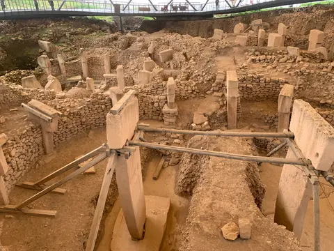
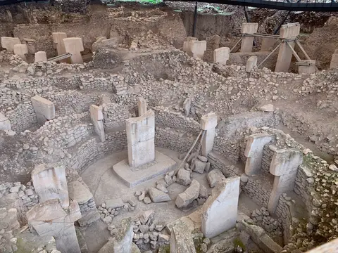
In Phase 1, dating to the second half of the 10th millennium BCE, builders established the earliest versions of circular compounds (Enclosures A to D) together with round-oval domestic houses pointing to a semi-sedentary lifestyle. Phase 2 in the early 9th millennium BCE introduced major structural walls built of unworked stone that embedded ring-shaped arrangements of monolithic T-shaped limestone pillars, paired with rising numbers of domestic buildings gradually shifting toward rectangular floor plans. Four circular enclosures ranging between 10 and 30 metres in diameter have been excavated so far, while geophysical mapping confirms at least 16 more buried across the mound, holding up to eight perimeter pillars each and approaching 200 megaliths in total. At the centre of each sunken enclosure, two taller freestanding T-pillars up to 5.50 metres high face one another from pedestals carved straight out of bedrock or set into polished burnt-lime terrazzo floors. Stone benches run along the inner perimeter walls for seated participants.
Later phases during the early Pre-Pottery Neolithic B (Phases 3 to 5) saw shifting architectural geometry on the northern and western slopes. Rectangular domestic houses underwent repeated alterations, adding benches with T-shaped pillars and extra dividing walls, while smaller doorless, windowless rectangular enclosures floored in polished lime mortar resembling Roman terrazzo replaced massive circles to use hilltop space more efficiently. These rectangular spaces housed central T-pillars up to 1.5 metres tall, exemplified by Building G and the Lion Pillar Building. Geological instability shaped the later stratigraphy: a major hillside landslide inundated lower-lying enclosures with domestic rubble, midden, and burials, damaging Enclosure D and prompting construction of defensive terrace walls in Phase 5 and Phase 7. A second major slope slide appears to have sealed Enclosure D by the late 9th millennium BCE, after which building output waned through Phases 6 and 7 before small habitation shelters occupied the ruins in Phase 8. Roughly 10 percent of the tell had been excavated by 2021, preserving most of the mound intact underground.
Animal Reliefs, Cranial Rituals, and Bedrock Quarries
Both high-relief and low-relief carvings turn Gobekli Tepe's structural limestone pillars into one of the richest iconographic records from the end of the last Ice Age. Artisans chipped away the softer limestone surface using hard flint blades and points to leave raised reliefs of wild fauna, avoiding domesticated animals entirely. Lions, bulls, wild boars, foxes, gazelles, and donkeys share pillar shafts with snakes, reptiles, spiders, insects, and large birds, especially vultures. Similar vulture imagery appears later in Anatolian Neolithic settlements such as Catalhoyuk and in Levantine sites like Tell es-Sultan (Jericho). These shared motifs link Gobekli Tepe into a broader regional symbolic world stretching across Cayonu, Qermez Dere, Gusir Hoyuk, Wadi Feynan 16, Jerf el-Ahmar, Tell 'Abr 3, and Tepe Asiab.
Anthropomorphic references remain intentionally abstract rather than naturalistic. Several T-shaped shafts display bent human arms and hands wrapped across the lower front edge, accompanied on rare examples by carved belts and loincloths. Because the horizontal top bar mirrors broad shoulders while omitting facial features, excavators interpreted each T-pillar as an abstract headless human figure, possibly depicting venerated ancestors, supernatural beings, or ritual participants gathered around the central twin monoliths. Discoveries in 2017 reinforced a funerary dimension: archaeologists identified incised human crania fragments within the mound, pointing to post-mortem skull preparation practices echoed in plastered-skull burials at Jericho, Tell Aswad, Yiftahel, and Catalhoyuk.
Moving out from the main tell onto the exposed limestone plateau illuminates how these megaliths left the earth. Workers pecked narrow trenches directly into bedrock quarries around 100 metres from the hillcrest, outlining monolithic slabs before prising them free. Dense concentrations of flint tools and broken limestone sculpture on the western ridge point to a probable carving workshop where a lion-like figure emerged. Nearby, the western escarpment hides a small cave bearing a lone bovid relief. Away from the main tell, Complex E, often termed the Temple of the Rock due to parallels with Nevali Cori, features a carefully smoothed bedrock floor with two carved pillar sockets and a surrounding flat bench. To its northwest sit two cistern-like pits, one holding a five-step staircase and a table-high pin. On the southern plateau, three undated phallic carvings sit beside four parallel quarry channels measuring 10 metres long and 20 centimetres wide. These channels link to later classical stone extraction near foundations possibly belonging to a Roman Limes Arabicus watchtower.
Visitor Access Zones and Museum Galleries for Gobekli Tepe
Statutory conservation under Turkiye's Law 2863/1983 (amended in 1987 and 2004) protects the tell and plateau as a 1st Degree Archaeological Conservation Site designated in 2005. A 3rd Degree buffer zone (registered 2016) surrounds the sanctuary, overseen by the Ministry of Culture and Tourism, Sanliurfa Museum, and a 2013 to 2017 management plan monitoring railway and visitor pressures. Modern visiting divides cleanly into the lower welcome facility, protected hilltop walkways, outlying plateau trails, and urban museum galleries in Sanliurfa.
| Complex Zone | Key Highlights | Access & Ticket Rule |
|---|---|---|
| Lower Visitor Centre & Shuttle Hub | Introductory archaeological exhibitions, stratigraphic timelines, and uphill shuttle transfer | Standard site admission required; private vehicles remain in the lower parking compound |
| Hilltop Excavation Walkways (Enclosures A to D) | Sunken circular PPNA enclosures, central twin T-pillars, terrazzo floors, and carved animal reliefs | Restricted to elevated wooden boardwalks beneath permanent tensioned shelter canopies |
| Western & Southern Plateau Margin | Neolithic bedrock quarry beds, Complex E platform traces, classical channels, and Harran plain views | Reached via marked exterior pedestrian paths circling the main mound loop |
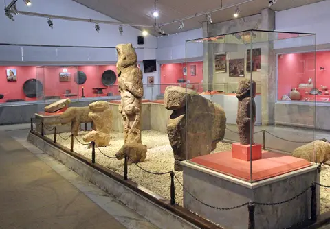
| Sanliurfa Archaeology Museum | Original carved T-pillars, small stone vessels, shaft-straighteners, and Enclosure D replica | Separate museum admission in central Sanliurfa; displays fragile finds removed from weather exposure |
Three Bedrock and Pillar Details to Spot at Gobekli Tepe
Even from the elevated viewing decks, looking closely at stone surfaces and floor joins clarifies how Pre-Pottery Neolithic builders solved structural problems with flint and burnt lime.
- Central Pedestal Sockets: Inside Enclosure D and its neighbours, look down at the base of the two tallest central T-pillars to see raised bedrock sockets carved directly out of the underlying limestone shelf rather than built from loose stones.
- High-Relief Animal Projections: Focus on the narrow front and broad side faces of the enclosures' main monoliths where foxes, boars, and vultures protrude in true three-dimensional high relief, achieved by labour-intensive chiselling back of the entire surrounding stone face.
- Neolithic Quarry Trenches on the Plateau: Along the exposed limestone apron outside the main roofed trenches, notice straight-edged grooves and partially cut stone outlines showing where workers used flint picks to isolate monolith blanks roughly 100 metres from the enclosures.
Seasonal Conditions and Pairing Gobekli Tepe with Sanliurfa
Upper Mesopotamia experiences stark seasonal contrasts across the Harran plateau. Intense summer heat builds across the exposed limestone ridge between midsummer and early autumn, making early morning arrivals essential when glare and wind-borne dust ease over the tell. Spring and late autumn deliver milder daytime temperatures and clearer visibility toward the Taurus foothills, while winter brings brisk winds and occasional rain across the exposed hilltop boardwalks.
Because conservation teams relocate small sculptures, incised bone finds, and key original stelae indoors for safekeeping, pairing the hilltop visit with our Sanliurfa city guide completes the archaeological record at the Sanliurfa Archaeology Museum 13 kilometres southwest. Travellers mapping prehistoric and classical monuments across Anatolia and the wider Mediterranean can continue planning overland circuits in the UNESCO World Heritage Atlas.