


























Quick Field Data
- UNESCO Inscription: 1981 · Criteria (vii), (viii), (ix), (x)
- Scale & Footprint: 348,000 square kilometres (marine park area approximately 344,400 square kilometres) extending across 14 degrees of latitude (10°S to 24°S) along the north-east coast of Australia
- Access & Ticketing: Regulated by the Great Barrier Reef Marine Park Authority (GBRMPA) under strict multi-use zoning; marine access operates via licensed vessels and dive boats departing coastal Queensland ports
- Arrival Logistics: Accessed from coastal cities along the Queensland seaboard including Cairns and Townsville alongside Mackay, Rockhampton, Gladstone, and Bundaberg, ranging from shallow inshore islands to outer shelf reefs up to 250 kilometres offshore
Continental Shelf Architecture and Cross-Shelf Diversity
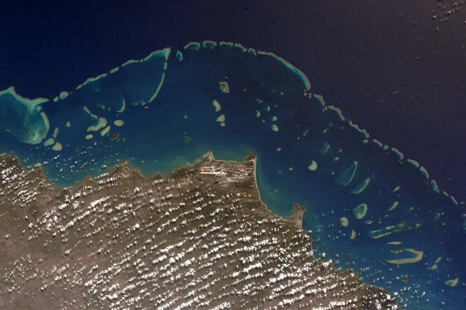
Inscribed on the World Heritage List in 1981, the Great Barrier Reef spans 348,000 square kilometres of the Coral Sea off the north-east coast of Queensland, Australia. Rather than forming a single continuous wall of coral, the system consists of between 2,500 and 2,900 individual reefs of varying dimensions alongside more than 900 islands (up to 940 islands and cays) distributed along a 2,300-kilometre north-south corridor from the northern tip of Cape York down to the coastal town of Bundaberg. Extending across a contiguous latitudinal range of 14 degrees between 10°S and 24°S, this marine complex occupies a shallow continental shelf where complex oceanic circulation links inshore seagrass beds with outer coral walls. Scale defines every aspect of this marine environment.
What gives the Great Barrier Reef its physical and biological variety is its cross-shelf depth profile combined with its 2,300-kilometre latitudinal span. The protected area stretches eastward from the low-water mark along the Queensland mainland for up to 250 kilometres offshore, before dropping off the edge of the continental shelf into oceanic waters exceeding 2,000 metres in depth. Across this transverse profile, island formations shift from low-lying sandy cays and larger vegetated coral cays on the outer and mid-shelf zones to rugged continental islands near the coast, one of which rises more than 1,100 metres above sea level. Beneath the surface, sunlight penetration and wave energy create distinct ecological zones across the water column, supporting roughly 400 types of coral and 4,000 types of mollusc and 1,500 species of fish, plus around 240 species of birds alongside sponges and anemones plus marine worms and crustaceans.
Crucially, this cross-shelf architecture provides critical breeding and feeding grounds for globally threatened marine megafauna. Extensive shallow inshore meadows of seagrass sustain one of the world's primary populations of the dugong (sea cow), while sandy island cays and coral lagoons provide nesting beaches and foraging grounds for the endangered large green turtle. Adjacent to the marine park lies the Great Barrier Reef catchment area on the Queensland mainland, where thirty major rivers and hundreds of smaller coastal streams drain 423,000 square kilometres of agricultural and forested land directly into the inshore lagoon.
Conservation History alongside Catchment Pressures and Thermal Bleaching
Active conservation of the reef ecosystem began in 1967, when public and scientific opposition halted a proposal to mine coral lime from Ellison Reef after ecological surveys demonstrated its rich community of living corals and fish. That campaign led to the passage of Australia's 1975 Great Barrier Reef Marine Park Act and the creation of the Great Barrier Reef Marine Park Authority (GBRMPA), followed by World Heritage inscription in 1981. Since 1989, however, marine scientists from the Australian Institute of Marine Science (AIMS) alongside the CSIRO and the University of Queensland, plus coral researchers at James Cook University, have documented mounting cumulative pressures across the 3,581 mapped reefs of the region.
Two distinct cause-and-effect mechanisms drive ecological stress across the marine park: land-based catchment runoff on the inner shelf and climate-induced thermal bleaching and ocean acidification across the broader Coral Sea. On the mainland catchment, where 596,000 hectares of forest were cleared between 2012 and 2016 for cattle grazing alongside sugarcane farming and banana horticulture, plus cotton growing and grain cropping, tropical flood plumes carry suspended acidic sediment and agricultural fertilisers into the lagoon. During the 2019 Townsville flood, river discharge plumes extended 60 kilometres out to sea, and roughly 700 of the 3,000 reefs sit within an inshore risk zone where reduced water visibility, recorded down to 10 metres in 1995, and chemical runoff degrade coral health. Industrial port expansions and seabed dredging at Gladstone and Curtis Island and Abbot Point (north of Bowen) plus Hay Point alongside Mackay and Townsville prompted World Heritage Committee warnings in 2010 and 2012, culminating in the Queensland Ports Bill 2014 and a 2015 regulation banning the marine disposal of capital dredge spoil, alongside Regulation 104 restrictions in 2019.
Even more severe is the impact of rising sea temperatures and ocean acidification mapped by CSIRO biogeochemical modellers such as Mathieu Mongin and coral researchers including Terry Hughes alongside Jon Day and Bob Pressey, plus Jon Brodie and Terry Done. When summer sea temperatures exceed normal thresholds, corals expel their symbiotic zooxanthellae algae and turn white; while scientist Ray Berkelmans documented localized recovery on the Keppel outcrops after 2006 where corals switched from heat-sensitive zooxanthellae strain C2 toward heat-tolerant types D and C1, repeated heatwaves outpace natural recovery times. Predictive models derived from the 1998 and 2002 bleaching data indicate that a global temperature rise of one degree Celsius bleaches 82 percent of reefs, while two to three degrees bleaches 97 percent and leads to widespread coral mortality, compounded when atmospheric carbon dioxide surpasses 380 to 450 parts per million. By 2022, the reef had suffered six mass bleaching events, including three between 2016 and 2020 and a fourth within seven years during the 2021 to 2022 La Niña summer that affected 91 percent of surveyed reefs.
Following a March 2022 UNESCO monitoring mission and updates to the Reef 2050 Long-Term Sustainability Plan in 2015 and 2021, the Australian and Queensland governments expanded statutory protections in May 2023. Commitments delivered to UNESCO Director Audrey Azoulay by Environment Minister Tanya Plibersek established net-free fishing zones across one third of the marine park by the end of 2024 alongside water quality improvement targets for 2025 and a complete phase-out of gillnet fishing by 2027 to protect dugongs and green turtles across inshore reef habitats.
Visiting the Inshore Islands and Outer Coral Shelf
Because the Great Barrier Reef stretches 2,300 kilometres from Cape York to Bundaberg and reaches up to 250 kilometres offshore, no single coastal town views the entire marine park. Travellers must choose between northern gateway ports such as Cairns and Townsville, where the continental shelf narrows and high-speed catamarans reach clear outer-shelf reefs quickly, and central or southern gateways near Mackay and Rockhampton alongside Gladstone and Bundaberg, which access continental island groups and southern coral cays.
Plan your marine itinerary around cross-shelf depth zones and seasonal water clarity.
- Select a coastal port by cross-shelf distance: Cairns and Townsville (each home to roughly 150,000 residents) act as the primary northern departure hubs for day boats and liveaboard dive vessels heading to mid-shelf and outer-shelf coral walls, where oceanic waters drop beyond 2,000 metres just outside the reef edge. Farther south along the Queensland coast toward Mackay alongside Rockhampton and Bundaberg, the continental shelf widens significantly, offering sheltered sailing around high continental islands alongside inshore Keppel outcrops and southern coral cays frequented by nesting green turtles.
- Prioritise outer reefs for visibility and coral diversity: Inshore reefs and seagrass meadows near river mouths support dugongs and coastal marine life, yet they also experience higher suspended sediment from the 30 major catchment rivers. For optimal underwater visibility exceeding the 10-metre inshore average and access to the highest density of the park's 400 coral types and 1,500 fish species, book licensed vessels regulated by the Great Barrier Reef Marine Park Authority that travel to mid-shelf lagoons and outer ribbon or platform reefs beyond the 60-kilometre coastal flood-plume zone.
- Time your visit outside the summer cyclone season: Avoid peak summer heat and tropical flood events, such as the December to March summer window when water temperatures peak and cyclones like Cyclone Debbie occur, by visiting during the cooler, drier winter and spring months, when trade winds moderate and underwater visibility across the Coral Sea is highest. To explore other protected marine and terrestrial ecosystems across Australia and worldwide, consult our UNESCO World Heritage Atlas.
