


























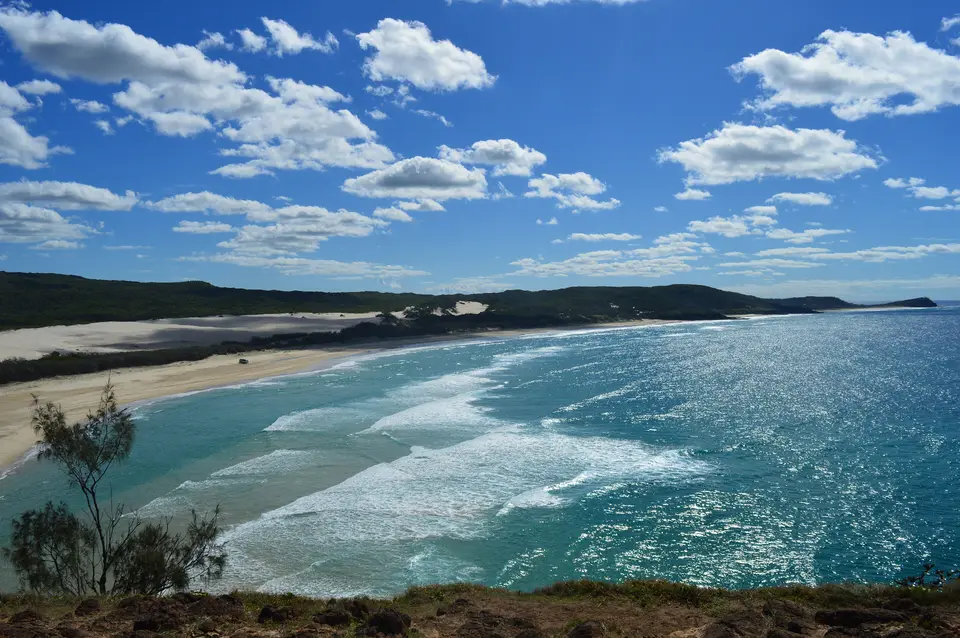
Quick Field Data
- UNESCO Inscription: 1992 (Natural heritage property off the southeastern coast of Queensland, Australia; officially restored to its Butchulla traditional name of K’gari in 2021 to 2023)
- Scale & Footprint: 181,851 hectares (1,840 square kilometres), measuring roughly 123 kilometres long and up to 22 kilometres wide as the largest sand island on Earth
- Access & Ticketing: Jointly managed by the Butchulla traditional owners and the Queensland Parks and Wildlife Service within Great Sandy National Park; check the official site for mandatory four-wheel-drive vehicle access permits and camping bookings
- Arrival Logistics: Roll-on/roll-off vehicular ferries cross the Great Sandy Strait from River Heads near Hervey Bay across the strait to Kingfisher Bay and Wanggoolba Creek, and from Inskip Point near Rainbow Beach to Hook Point
Quaternary Aeolian Sand Dunes, Coffee Rock, and Perched Lakes
Stretching 123 kilometres along the southern Queensland coast across the narrow shelter of the Great Sandy Strait from Hervey Bay, K’gari, formerly known as Fraser Island, encompasses 181,851 hectares of shifting transgressive dunes, freshwater lakes, and lush coastal forests as the world's largest sand island. Within Australia, the UNESCO World Heritage Atlas in 1992 and protected within Great Sandy National Park on the Fraser Coast, the island takes its official name from the creation story of the Butchulla people, whose oral tradition recounts how the spirit princess K’gari helped the messenger god Yendingie shape the land and seas before asking to remain forever in this paradise, where she was transformed into the sky-reflecting island studded with lakes as her eyes and clothed in trees and flowers.
From a geological standpoint, K’gari represents the culmination of more than 700,000 years of Quaternary coastal sediment drift and wind-driven dune building across multiple glacial and interglacial sea-level cycles. Weathering of granite mountains and sandstone ranges across eastern New South Wales carried immense volumes of siliceous quartz sand down rivers to the Tasman Sea, where powerful southeastern ocean swells and longshore currents swept the sand northward along the continental shelf. Whenever Ice Age sea levels dropped and exposed the wide coastal floor, southeasterly prevailing winds blew the sand inland into at least eight distinct generations of overlapping parabolic dunes, the oldest of which dates back some 750,000 years. Rising across widths of up to 22 kilometres to reach 244 metres above sea level at its highest dunes, the island rests over low volcanic outcrops visible only at Indian Head, around Waddy Point, and beside Middle Rocks along the eastern beach, while continuous podzol soil development in the aging dunes has created the deepest soil profiles recorded anywhere in the world, descending up to 25 metres before hitting parent sand. Pure quartz sands shape every ridge.
Containing over half of all perched freshwater dune lakes globally, K’gari contains over 100 coastal lakes characterized by extraordinarily pure, slightly acidic, low-nutrient rainwater. Approximately 40 of these basins are perched lakes, such as Lake McKenzie (Boorangoora) at 100 metres above sea level and Lake Boomanjin, which covers 200 hectares as the largest perched lake on Earth. Perched lakes form when wind-blown organic leaves, bark, iron, and humic acids wash down through a dune depression and cement with sand grains into an impervious dark brown layer known as "coffee rock", trapping rainfall well above the regional water table. Where wind erosion scours a dune deeper than the surrounding groundwater level, window lakes such as Lake Wabby emerge, while barrage lakes form where mobile sand blows block the course of a flowing freshwater creek like Eli Creek, which discharges 80 million litres of crystal-clear water daily onto 75 Mile Beach.
Rainforests Rooted in Quartz Sand and Acid-Adapted Wildlife
Nowhere else on the planet do tall, closed rainforest canopies reach heights of up to 50 metres growing directly in nutrient-poor quartz sand dunes above 200 metres elevation. Across K’gari's sheltered central inter-dune valleys along Bogimbah Creek and Wanggoolba Creek, natural mycorrhizal fungi living in symbiosis with tree roots release nutrients locked inside the sand and deep podzol horizons, sustaining over 865 species of vascular plants. Magnificent stands of satinay, Syncarpia hillii, and brush box, brush box, whose dense, marine-borer-resistant timber was harvested in the 19th and 20th centuries to line the Suez Canal, rise, and giant kauri pines, Agathis robusta, hoop pines, hoop pines, and the primitive angiopteris king fern, Angiopteris evecta, boasting the largest fern fronds in the world.
Away from the central rainforest core, vegetation zones shift symmetrically from west to east in response to salt spray, wind exposure, and soil age. Along the calm western shore bordering the Great Sandy Strait, tidal mudflats and mangrove forests transition into ancient wallum sedgelands and banksia heathlands, while behind the active eastern foredunes and expansive sandblows, such as the coastal sandblows that advance up to one or two metres a year, grow eucalypt scribbly gum woodlands and tall blackbutt forests.
This mosaic of wetlands, wallum swamps, and dune forests supports around dozens of species of mammals, over 350 species of birds, and numerous species of reptiles and amphibians. Because the acidic, low-pH waters of the wallum swamps and perched lakes deter most common amphibians, the island functions as a vital stronghold for specialized "acid frogs", including the Cooloola sedgefrog, Wallum froglet, Wallum rocketfrog, . Along the beaches and inland tracks roam Australia's purest remaining population of wild dingoes, known to the Butchulla as wongari, which have remained genetically isolated from domestic dog hybridization on the mainland. Offshore in the calm waters of Platypus Bay and Hervey Bay, humpback whales pause with their newborn calves between July and November during their migration between southern polar waters and the Great Barrier Reef, while dugongs, green and loggerhead sea turtles, and migratory shorebirds such as the eastern curlew feed across the Ramsar mudflats of the Great Sandy Strait.
Four-Wheel-Drive Sand Tracks, 75 Mile Beach, and the Great Walk
With no sealed bitumen roads anywhere on K’gari outside small resort enclaves, all overland travel takes place in high-clearance four-wheel-drive vehicles driving along inland deep-sand forestry tracks or timing coastal runs around low tide along the official gazetted highway of 75 Mile Beach. For tens of thousands of years before Captain James Cook sailed past in May 1770 and before the 1836 shipwreck of Captain James Fraser and Eliza Fraser on the Stirling Castle gave rise to the colonial name Fraser Island, and before a historic grassroots conservation campaign led by John Sinclair and FIDO ended commercial sand mining and logging in 1991, the Butchulla people sustainably managed the island across seasonal camps evidenced by shell middens, scarred trees, and stone artefacts.
- Central Station rainforest, Wanggoolba Creek, and Lake McKenzie: Drive the inland sand tracks from the western ferry landings at Kingfisher Bay or Wanggoolba Creek to Central Station, once a busy early twentieth-century forestry camp and school. Walk the elevated timber boardwalk beside the silent, glass-clear waters of Wanggoolba Creek where ancient king ferns and towering satinays grow directly from a sandy streambed, then continue to the white silica shores and cobalt waters of perched Lake McKenzie (Boorangoora) for a freshwater swim.
- 75 Mile Beach highway, Eli Creek, and the Maheno wreck: Plan your eastern beach transit strictly around the two hours either side of low tide to drive along 75 Mile Beach past the rusting steel hull of the SS Maheno, a luxury trans-Tasman ocean liner washed ashore by a cyclone in July 1935. Stop to wade down the boardwalk and swift freshwater current of Eli Creek, inspect the rainbow-coloured cliffs of the Pinnacles Coloured Sands stained by iron oxides over hundreds of thousands of years, and climb the volcanic headland of Indian Head to watch sharks, rays, and whales before refreshing in the ocean rock pools of the Champagne Pools.
- Lake Wabby, shifting coastal sandblow, and the K’gari Great Walk: From the eastern beach near Eurong, hike across the shifting golden expanse of the shifting coastal sandblow to look down into the emerald crescent of Lake Wabby, the island's deepest window lake at 12 metres, which is slowly being filled in by the advancing dune while supporting a dozen species of native fish. Experienced bushwalkers can also tackle sections of the 90-kilometre K’gari Great Walk linking the southern camps and Happy Valley via Lake Boomanjin, Lake McKenzie, Lake Allom, and Pile Valley.
