


























Quick Field Data
- UNESCO Inscription: 1986, designated for exceptional natural phenomena alongside key habitats of threatened subtropical biodiversity.
- Scale & Footprint: Covers 185,262.5 hectares across the western edge of Paraná state in southern Brazil, forming one of the largest protected forest tracts in South America.
- Access & Ticketing: Visitor entry and trail access operate through the official park administrative complex near the western cataracts; check the official site for current admission policies and environmental regulations.
- Arrival Logistics: Reached via regional highway and transport corridors linking the municipal gateway of Foz do Iguaçu with surrounding municipalities in Paraná.
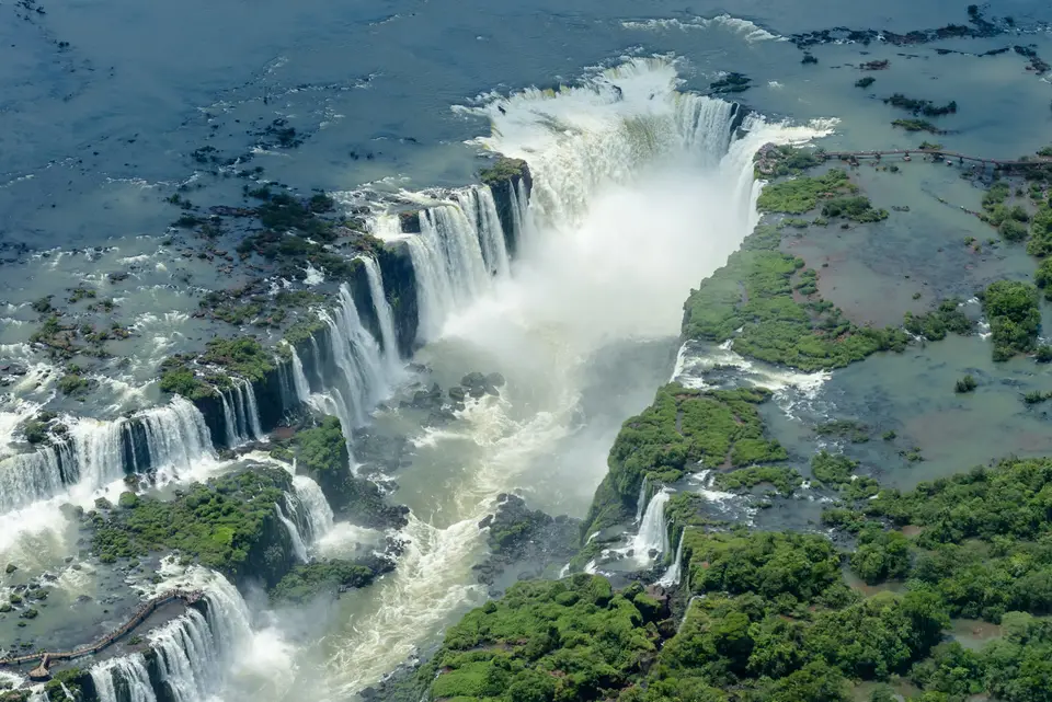
Iguaçu National Park occupies a prominent riverine corridor in the western sector of Paraná state, Brazil, sharing an international hydrological boundary with Argentina across the Iguazu River. From 1986, the UNESCO World Heritage Atlas in 1986, this expansive conservation unit encompasses 185,262.5 hectares of protected terrain and forms one of the largest surviving remnants of the interior Atlantic Forest biome in South America. Together with its contiguous Argentine sister park across the river channel, the transboundary protected zone covers roughly 250,000 hectares of subtropical forest and riparian ecosystems. Its geographical footprint stretches across an elongated east-to-west axis that widens toward its eastern forests and narrows along the canyon corridor leading to the cataracts. Travellers basing their exploration in Foz do Iguaçu encounter a dramatic geological transition where a wide plateau river plunges over an ancient volcanic escarpment into a turbulent lower gorge. Water roars through the basalt canyon.
Basaltic Escarpments and the Semicircular Cataract Amphitheatre
The geological spine of the park belongs to the Paraná Basin, where ancient flood basalts create a stepped terrain of dark volcanic rock. As the Iguazu River flows westward from its headwaters near the Serra do Mar outside Curitiba, it traverses the plateau before encountering a sudden structural fault and basaltic step approximately 18 kilometres upstream from its confluence with the Paraná River. At this point, the river channel widens dramatically before dropping over a semicircular cliff face measuring roughly 2,700 metres across. Vertical drops along this horseshoe-shaped rim reach up to 80 metres in height, splitting the river volume into hundreds of individual cascades that vary in width and force according to seasonal rainfall across the upper catchment.
At the heart of this semicircular amphitheatre lies a deep central canyon chasm where the main volume of the river converges in a roaring wall of water and permanent mist. The sheer mechanical energy of the falling water generates continuous clouds of spray that drift across the surrounding basalt ledges and saturate the adjacent canyon walls. Over geological time, headward erosion of the underlying basalt layers has caused the waterfall line to retreat upstream, leaving behind a narrow lower gorge where surging rapids channel the water toward the Paraná River. In 1939, Federal Decree 1035 formally established the Brazilian national park to safeguard the scenic cataracts and the surrounding pristine subtropical woodland under federal protection.
Hydrological patterns across the park are shaped by a humid subtropical climate regime that shifts toward a tropical transition along its lower western elevations. The Iguazu River acts as the principal drainage artery, joined inside the park boundaries by northern tributaries including the Floriano River alongside clear forest streams such as the Poço Preto and Macuco watercourses. Outside the immediate canyon of the waterfalls, the landscape softens into gently rolling hills and alluvial plains situated up to 300 metres above sea level. Soils derived from weathered basalt, predominantly red latosols, and hydromorphic and alluvial deposits along stream margins, support dense vegetation strata that buffer the river watershed against agricultural runoff from the surrounding countryside.
Interior Atlantic Forest Strata and Threatened Subtropical Fauna
Because the reserve spans multiple elevation gradients and microclimates, it sustains three distinct forest formations within the Atlantic Forest biome. The western and lower territories are dominated by seasonal semideciduous forest, where tall canopy trees shed part of their foliage during cooler, drier periods and shelter rich undergrowth layers of palms, lianas, and vascular epiphytes. Moving eastward into higher elevations, this formation transitions into mixed ombrophilous forest characterised by groves of native Brazilian pine (araucaria), a conifer species classified as threatened across its native range. Along floodplains and poorly drained depressions, pioneer alluvial communities of grasses, sedges, and moisture-tolerant shrubs stabilise the riverbanks, while specialised rupicolous plants cling directly to wet basalt outcrops inside the spray zone of the cataracts.
Botanical inventories across these habitats have documented hundreds of vascular plant species, including valuable hardwood and canopy trees such as peroba-rosa, cedro, and the threatened juçara heart-of-palm tree alongside dense ferns and orchids. This complex floral architecture provides critical refuge for rare and endangered South American mammals that require large, unbroken territories to survive. Apex predators and large herbivores recorded inside the park include the jaguar, puma, ocelot, South American tapir, giant anteater, giant otter, bush dog, and marsh deer. Forest deer, capuchin monkeys, howler monkeys, and social coatis also inhabit the dense forest interior and the riparian margins along the upper river.
Avian and aquatic diversity is equally pronounced across the riverine and forest zones. Hundreds of bird species have been recorded within the park boundaries, highlighted by endangered Atlantic Forest endemics such as the black-fronted piping guan, the vinaceous-breasted amazon parrot, the red-spectacled amazon, the purple-winged ground dove, and the powerful harpy eagle. Around the waterfalls themselves, flocks of great dusky swifts nest on sheer, spray-drenched rock ledges directly behind the cascading curtains of water, flying straight through the falling spray to reach their cliffside roosts. Reptilian life includes the broad-snouted caiman and freshwater river turtles, while the isolated river stretch above the falls supports distinct native fish assemblages alongside colourful congregations of butterflies that gather on mineral-rich mud banks along the forest trails.
Traversing the Canyon Walkways and Managing Border Pressures
Public visitation is concentrated inside a carefully regulated tourist zone near the western cataracts, leaving the vast majority of the eastern forest interior strictly dedicated to biological conservation and scientific research. From the main visitor reception complex outside the park boundary, internal transport shuttles follow a paved corridor through regenerating secondary forest toward the canyon rim. A panoramic pedestrian trail descends along the Brazilian cliff face opposite the Argentine cascades, providing wide frontal views of the entire waterfall system before terminating on a cantilevered walkway that extends directly into the misty cauldron of the central chasm. Upriver boat excursions and forest tracks such as the Poço Preto and Macuco routes allow visitors to observe riparian vegetation and birdlife away from the main cataract viewing platforms.
Managing a biological island of this scale requires continuous vigilance against external pressures along its agricultural perimeter in western Paraná, bordering municipalities such as Céu Azul, Matelândia, Medianeira, and São Miguel do Iguaçu, as well as Santa Terezinha de Itaipu alongside Capanema and Santa Tereza do Oeste, and Serranópolis do Iguaçu. Between 1999 and 2001, the park was temporarily placed on the List of World Heritage in Danger after local actors illegally reopened an 18-kilometre unpaved road through the forest, which sliced across the reserve and fragmented wildlife corridors between the northern and southern sectors. Federal enforcement subsequently closed the illegal track and allowed natural forest regeneration to reclaim the clearing. Ongoing conservation management also monitors water level fluctuations and altered thermal regimes linked to upstream hydroelectric dams, alongside ranger patrols against poaching, illegal palm harvesting, and agricultural chemical drift.
Across the seasons, the interplay between rainfall over the Paraná plateau and the volume of water plunging into the basaltic gorge continually reshapes the visual and acoustic character of the cataracts. During periods of high river flow, individual cascades merge into a continuous curtain of white water stretching across the full width of the semicircular cliff, sending mist plumes high above the surrounding subtropical canopy where rainbows form in the morning and afternoon sun. During drier intervals, the dark volcanic rock ledges emerge between separate ribbons of water, exposing the horizontal layering of ancient lava flows and the specialized aquatic plants that anchor themselves directly to the wet stone.
Careful field preparation ensures a rewarding visit across the canyon viewpoints and forest trails.
- Waterproof protection in the spray zone: Bring a lightweight rain jacket and sealed dry bags for cameras and electronics before stepping onto the lower canyon walkway, where heavy windblown spray is constant.
- Optimal morning light on the Brazilian rim: Because the Brazilian trail faces east and southeast toward the main wall of cascades, morning visits offer direct sunlight across the waterfalls and frequent rainbows over the lower gorge.
- Respect wildlife along forest trails: Never feed coatis or primates near trail rest areas and shuttle stops, as human food alters natural foraging behaviour and provokes aggressive encounters.
