


























Quick Field Data
- UNESCO Inscription: Inscribed in 1982 as a Natural heritage site under criteria (vii) and (x) in the Tasman Sea, New South Wales, Australia.
- Scale & Footprint: Twenty-eight islands alongside islets and rocks covering 1,540 terrestrial hectares (14.55 square kilometres on the main island) within a 146,300-hectare marine and terrestrial World Heritage area.
- Access & Ticketing: Resident population was 445 in 2021 and tourists are restricted to a maximum of 400 at any one time; check the official site and secure lodging before booking flights.
- Arrival Logistics: Located 600 kilometres east of Port Macquarie and 780 kilometres northeast of Sydney, served by commuter flights from Sydney and Gold Coast alongside Newcastle and Port Macquarie.
Eroded Shield Volcanoes and the Southernmost Coral Reef
The island is tranquil. Volcanic peaks tower above the lagoon. Born from submarine volcanic activity more than 2,000 metres under the sea in the Tasman Sea between the Australian mainland and New Zealand, the Lord Howe Island Group lies 570 to 600 kilometres (370 miles, or 320 nautical miles) east of Port Macquarie, 780 kilometres (480 miles, or 420 nautical miles) northeast of Sydney, and about 900 kilometres (560 miles, or 490 nautical miles) southwest of Norfolk Island. Irregularly crescent-shaped, the main island stretches roughly 10 kilometres (6.2 miles) from north to south while varying in width from 0.3 to 2.0 kilometres (0.19 to 1.24 miles) across an area of 14.55 square kilometres (3,600 acres), though just 3.98 square kilometres (980 acres) comprise the low-lying developed northern part of the island where most of the 445 residents live (a population density of 30.58 per square kilometre in 2021). Showing the advanced marine erosion of an ancient shield volcano composed of diverse upper mantle and oceanic basalts, the southern part of the island rises into forested mountains culminating in Mount Lidgbird and the highest point, Mount Gower, at 875 metres (2,871 feet).
In total, 28 islands alongside islets and sea rocks make up the Lord Howe Island Group. Beyond the main island and Blackburn Island inside the lagoon, the most notable features are the Admiralty Group (a cluster of 7 uninhabited islets to the north), the Mutton Bird Islands, and the uninhabited volcanic spire of Ball's Pyramid (or Balls Pyramid) rising 23 kilometres (14 miles, or 12 nautical miles) to the southeast. Along the western shore of the main island stretches a sheltered, sand-floored coral reef lagoon. Holding the world's most southerly true barrier coral reef, the waters represent an ecological transition zone where algal beds and coral reefs meet and where temperate and tropical forms cohabit at their ecological limits across the 146,300-hectare World Heritage area.
Lying within New South Wales (inside the Port Macquarie electoral district and Division of Sydney, postcode 2898) and legally an unincorporated area administered by the self-governing Lord Howe Island Board reporting to the state Minister for Environment and Heritage in New South Wales, the island belongs to the Pacific Subtropical Islands IBRA bioregion (subregion PSI01, covering 1,909 hectares or 4,720 acres) and the Lord Howe Island subtropical forests WWF ecoregion (14 square kilometres in the Australasian moist broadleaf forest biome). Under the 1981 Lord Howe Island Act, roughly 70 to 75 percent of the land (approximately 1,540 hectares) was protected as a Permanent Park Preserve, complemented by the surrounding Lord Howe Island Marine Park, the New South Wales State Heritage Register listing of 2 April 1999, and the Australian National Heritage List designation (number 105694) on 21 May 2007.
First Fleet Sightings, Kentia Palms, and Rediscovered Endemics
Before European discovery, the island remained completely uninhabited and unknown to South Pacific Polynesian navigators: following thorough archaeological fieldwork in 1996, researcher Atholl Anderson concluded in 2003 that there is no evidence of pre-European settlement on the 16-square-kilometre island despite its position between Pitcairn Island and Norfolk Island. European discovery occurred on 17 February 1788 when HMS Supply, the oldest and smallest armed tender of the First Fleet under Lieutenant Henry Lidgbird Ball (sailing from Botany Bay with 9 male and 6 female convicts to establish a Norfolk Island penal settlement), spotted the island. Sailing back on 13 March 1788, Ball sighted Ball's Pyramid and landed a crew on Lord Howe Island to claim British sovereignty, capturing 13 large turtles and tame birds for Port Jackson (recorded in Sydney on 19 March 1788 by surgeon Arthur Bowes Smyth) while giving his own name to both Mount Lidgbird and Ball's Pyramid and naming the main island in honour of First Lord of the Admiralty Richard Howe, 1st Earl Howe.
In May 1788, four First Fleet vessels (HMS Supply alongside Charlotte, Lady Penrhyn, and Scarborough) called at the island, when plant and animal life was recorded in the journals of Supply master David Blackburn and Lady Penrhyn surgeon Arthur Bowes Smyth, and in watercolour sketches by George Raper and John Hunter depicting the Lord Howe woodhen alongside the white swamphen and Lord Howe pigeon before the latter two birds were hunted to extinction. Located in the Middle Ground whaling region famous for both sperm and southern right whales (where the American whaling fleet numbered 675 ships between 1789 and 1791 and ships of the Second and Third Fleets called between July and October 1791 while whale oil remained Australia's leading export until the 1830s), the island was permanently settled in June 1834 when Captain John Blinkenthorpe of the British whaling barque Caroline landed three men (George Ashdown and James Bishop and Chapman) accompanied by their Māori wives alongside two Māori boys at Blinky Beach to build huts at Old Settlement. Bought out for 350 pounds in September 1841 by entrepreneurs Owen Poole and Richard Dawson (who were later joined by John Foulis before they abandoned the settlement in 1847 after failing to obtain a lease), the island saw the trading cutter Rover's Bride serve 5 to 12 or occasionally 20 ships a year between 1839 and 1859, the first children born in 1842 and 1844, the Andrews family cultivate the famous Lord Howe red onion in 1848 for 30 years until smut disease struck, and the population grow from 11 in 1849 to 16 in 1851 while NSW penal settlement proposals were aborted between 1851 and 1853. Between 1851 and 1854, Captain Henry Denham of HMS Herald (on its 1852 to 1856 Pacific expedition) completed the first hydrographic survey with Scottish biologists William Milne, John MacGillivray, and Denis Macdonald, while in 1853 the American whaling barque Belle under Captain Ichabod Handy landed George Campbell (died 1856), Jack Brian (left 1854), and Nathan Thompson, who brought Botanga, Bogoroo, and Bogue from the Gilbert Islands and built the first substantial cedar house in the 1860s as trade peaked between 1855 and 1857. When whaling declined, the 1880s saw the start of the worldwide export of endemic kentia palms alongside tourism after World War II ended in 1945.
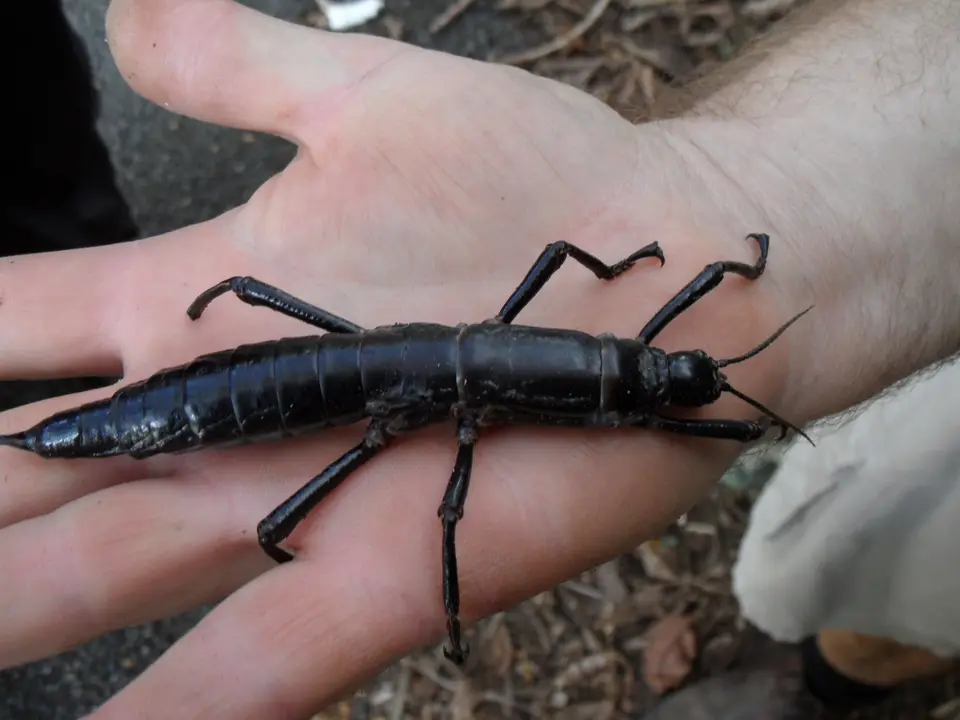
Today, the islands shelter distinctive endemics led by the flightless Lord Howe Woodhen (Gallirallis sylvestris), formerly counted among the world's rarest bird species, alongside the giant stick insect known as the Lord Howe Island Phasmid (Dryococelus australis), which scientists believed extinct until a surviving population was rediscovered on Balls Pyramid. The archipelago also functions as the sole major breeding ground for the Providence Petrel (Pterodroma solandri) while supporting one of the highest global breeding concentrations of the Red-tailed Tropicbird (Phaethon rubricauda).
Walking the Lagoon and Climbing Mount Gower Today
Bicycles outnumber cars here. With only 445 residents recorded in the 2021 census and visitor beds capped at 400 tourists at any time, exploring the Permanent Park Preserve revolves around walking tracks and lagoon reefs.
- Entry and Route Around the Crescent: Fly into the island airstrip on commuter flights from Sydney, Port Macquarie, Gold Coast, or Newcastle, rent a bicycle in the northern lowland settlement, and ride between Blinky Beach on the east coast and the sheltered coral lagoon on the west.
- Tickets, Interiors and Viewpoints: Northern trails overlooking the Admiralty Group are open to self-guided hikers, while the demanding climb to the 875-metre summit of Mount Gower requires a registered guide; check the official site for guided trek schedules and quarantine rules.
- Timing and Onward Connections: Snorkel the southernmost coral reef in the western lagoon and watch Red-tailed Tropicbirds and Providence Petrels along the sea cliffs, then explore more oceanic island ecosystems in our UNESCO World Heritage Atlas.
