Quick Field Data
- UNESCO Inscription: 2025 (Ref. 1728), natural geological and coastal reserve on Møn island, Denmark; Criterion (viii).
- Scale & Footprint: 4,123 hectares spanning six kilometres of white Baltic chalk cliffs and nearly five kilometres inland across marginal moraine hills.
- Access & Ticketing: Trails through Klinteskov woods and wooden beach staircases are managed by Vordingborg Municipality and the Danish Nature Agency; GeoCenter Møns Klint charges separate exhibition admission.
- Arrival Logistics: International flights land at Copenhagen Kastrup Airport (CPH), 72 kilometres north (Copenhagen Roskilde Airport RKE lies 71 kilometres northwest with limited flights), 78 kilometres south of Copenhagen.
Pleistocene Ice Thrusts and Cretaceous Chalk Strata at Møns Klint
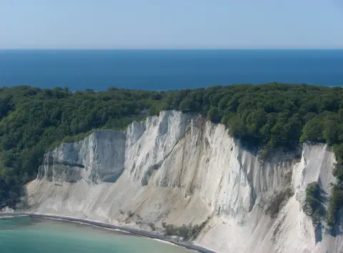
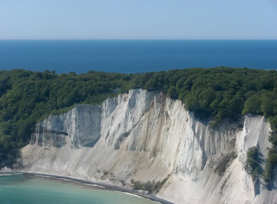
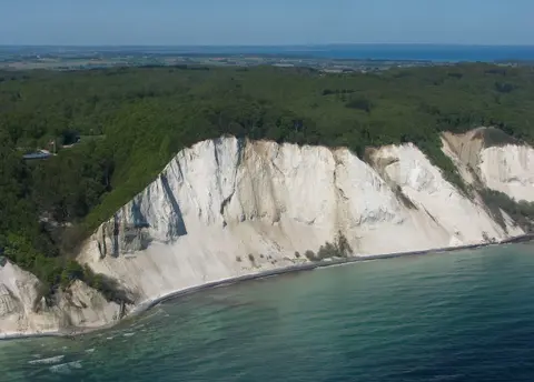
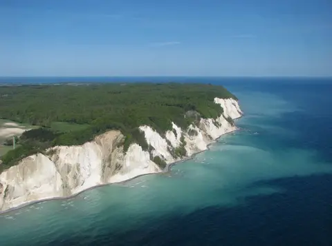
Stretching along the eastern tip of the Danish island of Møn in the Baltic Sea, Møns Klint exposes six kilometres of white chalk cliffs above flint beaches. Inscribed onto the UNESCO World Heritage List on 13 July 2025, this 4,123-hectare natural reserve extends almost five kilometres inland across rolling hills, kame-and-kettle depressions and glacial outwash plains. Inland slopes reach 142 metres at Aborrebjerg, ranking among Denmark's highest hills, while sheer coastal walls plunge 120 metres to the surf and peak at 128 metres at Dronningestolen, The Queen's Chair.
Chalk beds exposed along these white faces accumulated over 70 million years ago on a warm Cretaceous seabed. Trillions of microscopic marine coccolithophores deposited calcium shells onto the ocean floor, compacting into chalk layers forming part of the same geological belt as Rügen across the Baltic in Germany. Much later, during the Pleistocene Ice Age, powerful Scandinavian glacier streams pushed westward across the basin, compressing, folding and thrusting thick sheets of Cretaceous chalk upward together with younger Quaternary clay and sand sediments.
When the last glacial ice melted roughly 11,000 years ago, uplifted chalk slabs emerged along eastern Møn as parallel marginal ridge hills reflecting ice advances from three separate glacier directions. Continuous Baltic wave attack and weathering have carved open a dramatic six-kilometre vertical cross-section rising up to 200 metres in coastal relief, exposing the inner geometry of one of the world's largest and best-described glaciotectonic complexes. Scientific research here directly advanced modern understanding of glaciotectonics, demonstrating the extent, fast flow and physical mechanics of ice sheets that shaped continental lowlands across the Northern Hemisphere. Field teams examine tilted chalk blocks, thrust planes and squeezed Quaternary glacial tills side by side inside one accessible coastal outcrop.
Even where sea erosion has trimmed earlier outer cliffs back into the Baltic, underwater seabed traces preserve the broader three-dimensional folded structure. Along the stony black flint beaches beneath the sheer white towers, pounding surf and seasonal frost continuously crack loose fresh chalk blocks, exposing fossilised ancient shellfish and marine shells for careful beachcombers and earth scientists. Inland hills provide the wider morphological context, displaying how each glacial advance piled up successive ridges, outwash plains and kettle depressions behind the coastal wall. Across this compact six-kilometre by five-kilometre headland, visitors can trace an entire Pleistocene glacial episode from upland moraines down to marine seabed chalk.
Calcareous Orchids, Beech Woods, and Golden Age Landscape Art
Alkaline chalk soils atop the headland nourish specialised habitats matching the bare cliff geology below. Inside Klinteskov woodland, lime-rich earth tints beech tree foliage a luminous, light spring green that remains visible throughout the summer months rather than darkening. Along sunlit calcareous grasslands, cliff verges and open clearings, botanists document 18 wild orchid species peaking in early summer, including tall lady orchids (Orchis purpurea) thriving directly beneath wooden beach staircases.
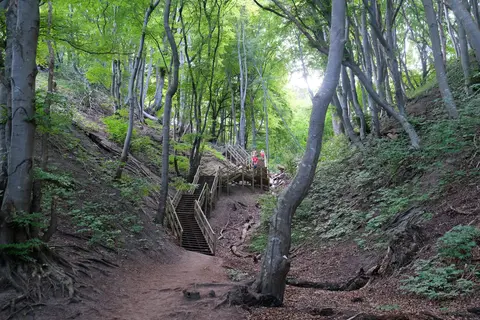
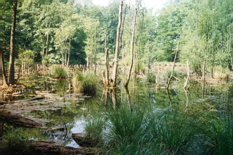
Beyond wildflowers, the hilly inland park of pastures, ponds and wooded marshes supports rare northern European wildlife. Open calcareous turf hosts the threatened Large Blue butterfly (Maculinea arion), which relies on chalk grassland flora and host ants to develop. High on inaccessible white cliff ledges, peregrine falcons breed and dive above the Baltic at speeds up to 350 kilometres per hour, earning Møns Klint recognition as an Important Bird Area by BirdLife International. Signposted forest loops allow walkers, riders and cyclists to traverse quiet wooded hollows between inland wetlands and cliff-edge overlooks.
Aesthetic fascination with these pale cliffs preceded modern geological tourism, which now brings roughly 250,000 visitors each year. During Denmark's nineteenth-century Golden Age, national romantic landscape painters including Christoffer Wilhelm Eckersberg and Louis Gurlitt repeatedly depicted the green beech woods, jagged white towers and turquoise Baltic surf. At the northern boundary lies Liselund Park, a late eighteenth-century romantic garden of small houses, rolling lawns and ponds built by Antoine de la Calmette for his wife Elisabeth (Lise). Inland to the west stands Klintholm Estate, or Klintholm Gods, preserving farm buildings from 1780 across large grounds where the former manor house was demolished in 2000 due to dry rot.
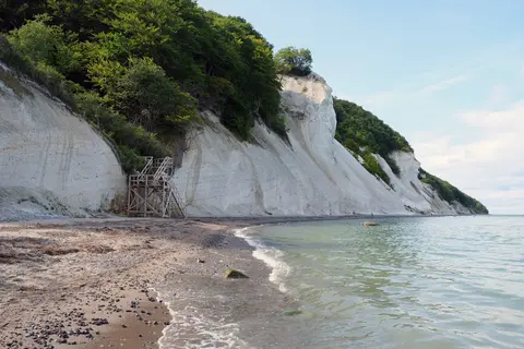
At the clifftop core near Dronningestolen, Queen Margrethe opened GeoCenter Møns Klint on 29 May 2007, following an international design competition won by PLH Architects. Exhibition galleries interpret 70 million years of marine chalk deposition, Pleistocene ice-stream deformation and fossil collecting right beside the main trailheads and wooden beach staircases. Stepping straight from museum halls onto elevated forest decks lets visitors trace ancient seabed history directly against sheer coastal cliffs and shaded beech woods below.
Beyond the main geological museum, surrounding farmland and forest tracks reveal how historical estates shaped the eastern headland over centuries. Walking between Dronningestolen, Store Taler and northern Liselund connects quiet woodland clearings, freshwater ponds and dramatic coastal overlooks in one continuous loop.
Coastal Landslides, Geoheritage Monitoring, and Høje Møn Rules
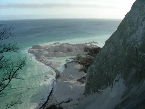
Coastal erosion drives both scientific discovery and active site hazards along Møns Klint. Waves undercutting steep, fractured chalk trigger periodic rockfalls that reshape the shoreline without warning. In 1998, the prominent chalk pinnacle known as Sommerspiret collapsed into the Baltic Sea. Nine years later, in January 2007, an even larger landslide around Store Taler in the northern cliffs pushed a 300-metre-long peninsula of shattered chalk and fallen beech trees out into the water, now known as Store Taler Fald.
Multiple Danish conservation statutes shield the six-kilometre shoreline and five-kilometre inland ridge zone from inappropriate development. Under the national Nature Conservation Act, a 300-metre Beach Protection Zone restricts shoreline construction, while the strict Høje Møn Protection order prohibits land-use changes, tree planting or buildings that would obstruct open ridge views. Overlapping rules inside the national Planning Act extend a three-kilometre Coastal Proximity Zone inland together with specific geological and scenic zoning protections.
Management blends public agency oversight with local private stewardship across Vordingborg Municipality. The Danish Nature Agency administers public woodlands, while Klintholm Gods, the sole large agricultural and forestry estate inside the reserve, manages fields, natural grasslands and timber under statutory conservation provisions overseen with landowners, stakeholders and a Scientific Advisory Board. Conservation crews selectively clear encroaching scrub from viewpoints and calcareous grasslands to safeguard orchids and rock faces while excluding commercial logging from protected woodland pockets. Joint monitoring programmes funded through the Globe Institute at the University of Copenhagen, the Geological Survey of Denmark and Greenland (GEUS) and GeoCenter Møns Klint track long-term cliff erosion, climate impacts, sea-level dynamics and ecological carrying capacity.
Balancing roughly 250,000 yearly visitors against fragile chalk trails and cliffside nesting sites guides planning across both public land and neighbouring estates. Managers analyse social and ecological carrying capacity across peak summer weeks to route heavy foot traffic toward hardened viewpoints, wooden staircases and educational museum displays while keeping sensitive orchid slopes and peregrine falcon ledges undisturbed. Ongoing geological inventorying also records newly exposed strata and coastal collapses so future generations can study active glaciotectonic erosion safely.
Access Zones Across Møns Klint and Klinteskov
Exploring Møns Klint links clifftop museum trails through Klinteskov forest with steep wooden staircases descending to the fossil-strewn Baltic beach. Always verify staircase closures and rockfall safety notices posted by rangers before descending to the shoreline.
| Complex Zone | Key Highlights | Access & Ticket Rule |
|---|---|---|
| GeoCenter & Dronningestolen | Modern geological museum opened in 2007, fossil displays, 128-metre cliff overlook and main wooden beach stairs. | Woodland viewpoints are free on foot; GeoCenter exhibition halls require paid admission on site. |
| Store Taler Northern Cliffs | Sheer glaciotectonic fault exposures and the 300-metre chalk debris peninsula left by the 2007 Store Taler rockfall. | Follow marked cliff-rim trails; avoid walking directly beneath overhanging chalk faces on the beach. |
| Klinteskov Woods & Aborrebjerg | Signposted walking, riding and cycling circuits through lime-tinted beech woods, orchids and 142-metre Aborrebjerg hill. | Public forest trails remain open year-round under Danish countryside and nature protection codes. |
| Liselund Park & Klintholm | Eighteenth-century romantic landscaped park, ponds and thatched pavilions at the northern cliff boundary. | Park paths open to pedestrians daily; verify opening rules separately for seasonal manor interiors and nearby camps. |
Three Geological and Coastal Details Along Møns Klint
- Deformed Chalk and Quaternary Bands: Look closely at dark diagonal streaks slicing across pale cliff walls from the beach to spot where Pleistocene glaciers wedged glacial till between uplifted Cretaceous chalk blocks.
- Black Flint Cobbles and Marine Fossils: Search sorted shingle beaches near Dronningestolen after winter storms for dark flint nodules and eroded Cretaceous shellfish fossils weathered straight out of fallen chalk.
- Calcareous Lady Orchids Under the Stairs: During early summer visits, watch fenced grassy slopes right beneath the wooden cliff staircases where tall Orchis purpurea orchids thrive in sunlit chalk turf.
Hiking Trails, Winter Visits, and Routes From Copenhagen
Travellers planning a Møns Klint hike from Copenhagen encounter sharp seasonal contrasts along the eastern headland. Summer delivers long sunny daylight, regular seasonal bus connections from Stege and Klintholm Havn and signposted walking, riding and cycling circuits through Klinteskov woodland above the bright Baltic surf. Early summer brings peak orchid blooms beneath the staircases and clear views across turquoise water, whereas visiting Møns Klint in winter delivers crisp quiet forest paths, open views through leafless beech branches and freshly eroded fossils along the flint shore. In cold or stormy months, walkers must check safety advisories carefully because frost, sea surges or chalk rockfalls can temporarily close wooden stairs.
Pacing a visit across half a day or a full weekend lets walkers combine clifftop beech forest loops with shoreline fossil walks and indoor exhibits inside GeoCenter Møns Klint. Nearby camping grounds, a youth hostel, hotels and guesthouses around eastern Møn allow early morning walks out to Dronningestolen and Liselund Park before afternoon arrivals fill the main car parks. Following marked routes linking Dronningestolen, Store Taler and northern Liselund covers the full geological cross-section from steep chalk promontories to historic landscaped ponds. Staying strictly on marked cliff trails and wooden staircases rather than eroded chalk banks shields delicate orchids and helps prevent cliff-edge soil wear.
Public and road links connect eastern Møn cleanly with Denmark's capital region. Regular regional bus services operate from Stege and Klintholm Havn during summer months, complementing car access via Stege across the island's southern farm belt. Signposted routes lead arriving visitors directly to cliff-rim car parks, visitor information desks and timber beach staircases without confusion. Road access south from Copenhagen (78 kilometres north) follows motorways across Zeeland and bridges onto Møn toward parking near GeoCenter Møns Klint. International travellers arrive at Copenhagen Kastrup Airport (CPH), 72 kilometres north of the cliffs, while Copenhagen Roskilde Airport (RKE) lies 71 kilometres northwest with far fewer commercial flights. Discover additional Nordic geological reserves inside our UNESCO World Heritage Atlas.