


























Quick Field Data
- UNESCO Inscription: 1978 (established in 1972 and 1976 at 470,000 hectares; expanded in 2009 to 30,050 square kilometres) · Natural Criteria
- Scale & Footprint: 470,000 hectares in the core World Heritage zone, expanded by 2,500,000 hectares in 2009 to cover 30,050 square kilometres (91 percent of the Greater Nahanni ecosystem)
- Access & Ticketing: Managed by Parks Canada in cooperation with the Dehcho First Nations; there is no road access into the interior canyons, and visitors to Zone 1 Rabbitkettle Hotsprings must be accompanied barefoot by park staff
- Arrival Logistics: Situated within Canada's Northwest Territories across the Dehcho Region roughly 500 kilometres west of Yellowknife, reached via floatplane charter or whitewater expedition along the South Nahanni and Liard rivers
Antecedent River Canyons and Rabbitkettle Tufa Mounds
Nahanni National Park Reserve lies across the Dehcho Region of Canada's Northwest Territories, approximately 500 kilometres west of Yellowknife within the Mackenzie Mountains Natural Region. Originally inscribed in 1978 across a 470,000-hectare (4,766-square-kilometre) core, the park was expanded by 2,500,000 hectares on 9 June 2009 to encompass 30,050 square kilometres, protecting 91 percent of the Greater Nahanni ecosystem and nearly the entire watershed of the South Nahanni River (known in the local Dene language as Naha Dehé or Nahʔa Dehé, translating to the river of the Naha people's homeland). Beginning near Moose Ponds and flowing southeast to join the Liard River near the community of Nahanni Butte, both the South Nahanni River and the tributary Flat River are rare antecedent rivers: older than the mountain ranges they dissect, they maintained their ancient meandering courses by cutting downward at the exact pace that tectonic uplift raised the bedrock.
Between 500 and 200 million years ago, an ancient inland sea deposited coloured layers of fossil-bearing limestone and shale alongside sandstone up to 6 kilometres deep. When the North American and Pacific plates later collided, tectonic compression folded and faulted these sedimentary strata into mountain ridges while injecting rising towers of heated magma (igneous batholiths) that pushed the overlying rock upward. Once erosion stripped the sedimentary cap, the hardened granite batholiths emerged at the western edge of the park as the jagged spires of the Ragged Range, crowned by the Cirque of the Unclimbables, the 2,570-metre Lotus Flower Tower, 2,759-metre Mount Sir James MacBrien, and 2,773-metre Mount Nirvana, the highest peak in the Northwest Territories. Because the Wisconsin Ice Age (85,000 to 10,000 years ago) glaciated only the westernmost and easternmost margins, the central river valleys preserved ancient raised meanders and unglaciated karst cave systems.
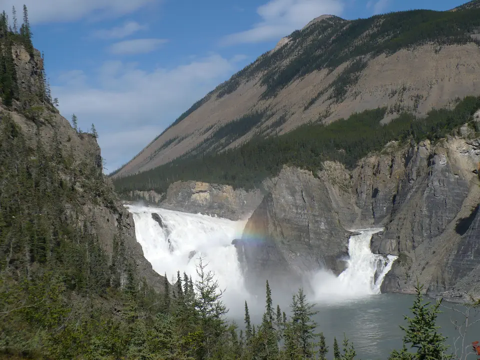
At Virginia Falls (called Nailicho in Dene), the South Nahanni River splits around a central limestone spire named Mason's Rock (honouring Canadian canoeist and filmmaker Bill Mason) and plunges 90 metres in a thundering cataract, creating a perpetual mist microclimate that nurtures boreal orchids including Calypso bulbosa, Cypripedium parviflorum, Cypripedium passerinum, Galearis rotundifolia, and three Platanthera species. Downstream, early prospectors numbered four consecutive gorges from east to west as they paddled upriver. Fourth Canyon (Painted Canyon or Five Mile Canyon) was carved directly upstream by the receding lip of Virginia Falls, followed by the rapids of Figure Eight, George's Riffle, and Lafferty's Riffle. Next, the 40-kilometre Third Canyon cuts through angled shale and sandstone plus limestone slopes in the Funeral Range before turning 45 degrees at Big Bend into the 15-kilometre Second Canyon through the Headless Range. Below Deadmen Valley, the 30-kilometre First Canyon slices through resistant limestone between vertical walls reaching 1,000 metres in height, ending near Kraus Hotsprings. Farther northwest near the Ragged Range batholiths, deep geothermal water dissolves subsurface calcium carbonate and precipitates porous calcite rims at the 10,000-year-old Rabbitkettle (Gahnîhthah) Hotsprings, building Canada's largest tufa mounds, where the terraced North Mound rises 27 metres high and 74 metres across.
Dene Mooseskin Boats and Cooperative Stewardship
Spanning the Taiga Cordillera and Taiga Plains plus the Boreal Cordillera ecozones, the park's sulphur springs and spruce-aspen forests below alpine tundra support more than 700 vascular plant species (including the endemic Nahanni aster), 300 bryophyte and lichen species, 42 mammal species, 180 bird species (including the sole documented nesting grounds of the whooping crane alongside peregrine falcons, gyrfalcons, harlequin ducks, and trumpeter and tundra swans), and 16 fish species such as Arctic grayling, inconnu, bull trout, and lake trout, plus the hardy wood frog. Ten species listed by the Canadian endangered-wildlife committee COSEWIC rely on the reserve, including woodland caribou, wood bison, grizzly bear, wolverine, short-eared owl, common nighthawk, olive-sided flycatcher, and rusty blackbird plus yellow rail, sharing the heights with Dall's sheep and Rocky Mountain goats.
For 9,000 to 10,000 years, Dene (Slavey) peoples have hunted and travelled across this watershed, leaving prehistoric archaeological sites at Yohin Lake and preserving oral histories of the mountain-dwelling Naha tribe. After European fur contact expanded in the 18th century following Alexander Mackenzie's charting of the Deh Cho (Mackenzie River) and the establishment of Hudson's Bay Company trading posts managed by Scottish explorer John McLeod at Fort Simpson and Fort Liard, Dene families settled near Fort Liard and Fort Simpson as well as Nahanni Butte. Each spring during the late 19th century, Mountain Dene families sewed six to ten untanned moose hides over a 20-metre spruce-pole frame (modelled on Hudson's Bay York boats) to float their families and pack dogs with winter fur catches down the flooded South Nahanni River to the trading posts before dismantling the hides and walking back into the mountains.
During the Klondike Gold Rush, prospectors attempting to reach the Yukon via the Flat and South Nahanni rivers gave rise to dark folklore after the headless corpses of Métis brothers Willie and Frank McLeod were discovered around 1908 near the rumoured Lost McLeod Mine, inspiring place names such as Deadmen Valley, Headless Creek, the Funeral Range, and the Headless Range. Later prospectors included Albert Faille (chronicled by writer Raymond M. Patterson) and Calgary geologist Frank M. W. Henderson, whose partner John Patterson vanished near Virginia Falls in 1946; in 1947, writer Pierre Berton flew up the Headless Valley alongside pilot Russ Baker for The Vancouver Sun and Maclean's. Modern exploration shifted in 1964 when Montreal parachutist Jean Poirel and Bertrand Bordet parachuted to the river's source 500 kilometres north of Yellowknife and descended in inflatable dinghies. Across four expeditions, Poirel mapped more than 250 karst caverns, including Valerie Cavern (named after his daughter and holding 116 Dall's sheep skeletons carbon-14 dated to 2500 BC), and escorted Prime Minister Pierre Elliot Trudeau in 1972 when Trudeau established the park. In June 2000, Canada and the Dehcho First Nations formed the Naha Dehe Consensus Team, securing interim protection for 23,000 square kilometres in 2003 and 5,400 square kilometres in August 2007 before enacting the 30,050-square-kilometre expansion on 9 June 2009.
Flying into Virginia Falls and Paddling the Four Canyons
Because no roads enter the core canyons of Nahanni National Park Reserve, every visitor arrives by charter floatplane or commits to a multi-week whitewater canoe or raft expedition down the South Nahanni River toward Nahanni Butte. The canyon walls tower.
- Entry and Route by Floatplane to Nailicho: Charter a floatplane from Fort Simpson, Fort Liard, or Yellowknife (500 kilometres east) to land on the river above Virginia Falls (Nailicho), where all overnight paddlers and day passengers register with Parks Canada staff. Walk the boardwalk portage trail through the mist-fed boreal orchid forest to the brink of the 90-metre cataract, where the South Nahanni splits around the limestone pinnacle of Mason's Rock.
- Tickets, Interiors and Viewpoints at Rabbitkettle and the Canyons: Visitors flying into the Zone 1 Special Preservation Area at Rabbitkettle (Gahnîhthah) Hotsprings must walk barefoot with a Parks Canada guide to protect the fragile porous calcite rims of the 27-metre North Mound. River expeditions launching below Virginia Falls navigate the Figure Eight, George's Riffle, and Lafferty's Riffle rapids through Fourth Canyon, Third Canyon in the Funeral Range, Big Bend, Second Canyon in the Headless Range, and Deadmen Valley before entering the 1,000-metre vertical limestone cliffs of First Canyon down to Kraus Hotsprings.
- Timing and Onward Connections in the Dehcho Region: The brief subarctic paddling and climbing window in the Cirque of the Unclimbables runs from late June through August after spring snowmelt subsides and before autumn freezes return to the Mackenzie Mountains. Connect your Northwest Territories expedition with neighbouring subarctic wilderness parks in our UNESCO World Heritage Atlas.
