


























Quick Field Data
- UNESCO Inscription: 1983 · Criteria (vii), (ix) and (x).
- Scale & Footprint: 44,741 to 44,807 square kilometres (4.5 million hectares, or 17,275 square miles) straddling northeastern Alberta and the southern Northwest Territories as Canada's largest national park and a vast Dark-Sky Preserve
- Access & Ticketing: Managed by Parks Canada (recording 2,399 visitors in 2022 to 2023) with headquarters in Fort Smith and a satellite office in Fort Chipewyan; entry is open via the all-weather Mackenzie Highway and Highway 5 corridor alongside charter flights or winter ice roads
- Arrival Logistics: Reached year-round by road via Highway 5 into Fort Smith (Northwest Territories) or by commercial air service from Edmonton to Fort Smith and Fort Chipewyan (Alberta), with winter ice-road access north from Fort McMurray
The Peace-Athabasca Inland Delta, Salt Plains, and Gypsum Karst
Encompassing 44,741 to 44,807 square kilometres (4.5 million hectares, or 17,275 square miles) across the boundary linking northeastern Alberta to the southern Northwest Territories, Wood Buffalo National Park (Parc national Wood Buffalo) is the largest national park in Canada, exceeding the entire surface area of Switzerland, and ranks second in area among all national parks worldwide. Established in 1922 on Crown lands acquired under Treaty 8 (signed on 21 June 1899 with regional First Nations) and On the World Heritage List in 1983 under natural criteria (vii) alongside (ix) and (x), the reserve protects the largest and most ecologically complete expanse of the Great Plains-Boreal grassland and woodland ecosystem in North America. On 28 June 2013, the Royal Astronomical Society of Canada also designated the park as the world's largest Dark-Sky Preserve, safeguarding nocturnal habitats for bats alongside nighthawks and owls while offering views of the northern lights. Wilderness stretches beyond every horizon.
Topographically, the park rises from 183 metres (600 feet) along the Little Buffalo River to 945 metres (3,100 feet) in the Caribou Mountains plateau, structured around three major subarctic river corridors that served for millennia as indigenous canoe highways: the Peace alongside the Athabasca and the Slave rivers (joined by the Birch and Jackfish rivers). In the southern sector of the park, the convergence of the Peace alongside the Athabasca and Birch rivers on the western edge of Lake Athabasca forms the Peace-Athabasca Delta, one of the largest freshwater inland deltas in the world. Across its vast, flat expanses of shallow perched basins and marshes alongside mudflats and sedge meadows, seasonal spring ice-jam floods replenish nutrients and sustain millions of migratory waterfowl.
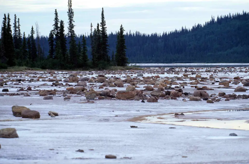
North of the inland delta, the park's boreal forests and prairies expose two rare geological landscapes: sprawling white evaporite Salt Plains where underground brine springs deposit crystalline salt mounds across the mudflats, and one of the finest examples of gypsum karst topography in North America across the northeastern sector. Within the Jackfish River drainage, groundwater dissolving subterranean gypsum and carbonate beds has carved deep collapsed sinkholes alongside underground caves and Neon Lake Springs, Alberta's largest karst spring system by volume, discharging an estimated 8 cubic metres of water per second.
For thousands of years since the retreat of the last ice age, this subarctic crossroads has been the homeland of Northern Athabaskan Dene peoples, including the Dane-zaa (Beaver) and the Chipewyan and the South Slavey peoples, alongside the Algonquian-speaking Woods Cree (who concluded a historic peace pipe treaty with the Dane-zaa at Peace Point after a post-1781 smallpox epidemic, giving the Peace River its name) and the Métis community that emerged after explorers Peter Pond (1785) and Alexander Mackenzie (1788) and British fur-trade posts at Fort Chipewyan and Fort Vermilion (1788). Today, the national park surrounds several First Nations reserves including Peace Point and Hay Camp, while on its southern Alberta border the Mikisew Cree First Nation and the Alberta government and industrial partners (including Teck Resources alongside Cenovus Energy and Imperial Oil) established Kitaskino Nuwenëné Wildland Provincial Park in March 2019 to buffer the ecosystem from industrial developments north of Fort McMurray.
Free-Roaming Wood Bison, Whooping Cranes, and the 850-Metre Beaver Dam
Wood Buffalo National Park was created in 1922 specifically to save the world's last free-roaming herds of wood bison (then numbering 1,500 to 2,000 animals). Between 1925 and 1928, however, against the warnings of biologists, the federal government shipped nearly 6,700 plains bison by rail and barge from overcrowded Buffalo National Park in Alberta into Wood Buffalo. Those introduced plains bison hybridized with the native wood bison and infected the herd with bovine tuberculosis and brucellosis. Although a genetically pure, isolated herd of 200 wood bison was discovered near the Nyarling River in 1957 (from which 23 animals were translocated in 1965 to the southern sector of Elk Island National Park, growing to 300 pure bison today), and despite commercial culls at Hay Camp between 1951 and 1967 that slaughtered 4,000 bison for 910 tonnes (2 million pounds) of meat, followed by a defeated 1990 proposal to eradicate the entire park herd and a 1992 court victory by the Canadian Parks and Wilderness Society cancelling a 1983 logging lease over 50,000 hectares, the diseases persisted. Today, the park sustains around 3,000 free-roaming bison (with the Sweetgrass Station and Slave River Lowlands herds retaining the closest morphology to early wood bison), supported by federal conservation commitments under the Wood Buffalo Action Plan of 27.5 million dollars in 2019 alongside 59.9 million in 2020 and 90 million over five years announced in 2026 to monitor the Peace-Athabasca Delta and recover wood bison populations.
In the remote northern bogs alongside marshes and shallow ponds of the park lies a second biological treasure of global significance: the Whooping Crane Summer Range, a designated Ramsar wetland discovered through the International Biological Program that constitutes the only natural, self-sustaining nesting habitat in the world for the endangered whooping crane. Protected by the sheer remoteness of the boreal wetlands, migrating whooping cranes return here each spring from their southern wintering grounds to raise their chicks and sandhill cranes and bald eagles alongside peregrine falcons, great grey owls, and snowy owls.
Sharing the boreal spruce and jack pine forests with the 3,000 bison are Northwestern wolves (which specialize in hunting bison across the open sedge meadows), American black bears and grizzly bears alongside Canada lynxes, wolverines, Western moose, American martens, snowshoe hares, North American beavers, and the world's northernmost communal hibernacula of red-sided garter snakes. In 2007, satellite imagery of a remote bog 200 kilometres (120 miles) from Fort Chipewyan revealed the world's longest known beaver dam, stretching approximately 850 metres (2,790 feet) across the wetland, built over decades by generations of beaver families.
Exploring the Salt Plains, Karst Sinkholes, and Dark Skies from Fort Smith
Because Wood Buffalo National Park spans 44,741 square kilometres of roadless boreal wilderness where winter temperatures plunge below minus 40 degrees in January and February (mean January high minus 21.7 degrees, low minus 31.8 degrees) while July brings long subarctic daylight and highs of 22.5 degrees (ranging from 10 to 30 degrees), the park receives only around 2,399 visitors a year. Experiencing the park centres on the all-weather Highway 5 corridor leading to Fort Smith or boat and air excursions out of Fort Chipewyan into the Peace-Athabasca Delta.
Plan your subarctic expedition around the Fort Smith visitor centre alongside the Salt Plains trails and the northern lights season.
- Register at Fort Smith and walk onto the Salt Plains: Drive into the park along the Mackenzie Highway and Highway 5 to check in at the Parks Canada visitor centre in Fort Smith. From Highway 5, drive out to the Salt Plains Lookout and descend the trail onto the stark white evaporite flats, where saline groundwater springs leave glistening salt crystals textured with the hoofprints of wood bison alongside wolves and black bears.
- Hike the gypsum karst sinkhole trails and paddle the Peace River: Follow the park road network to the karst sinkhole lake recreation area and hike the boreal forest trails to inspect collapsed gypsum sinkholes and the red-sided garter snake dens. Experienced paddlers can register for multi-day backcountry canoe expeditions down the Peace or Slave rivers or charter a boat from Fort Chipewyan into the channels of the Peace-Athabasca Delta.
- Observe the aurora borealis in the Dark-Sky Preserve: Visit during late summer and early autumn (when Fort Smith hosts dark sky events and night skies darken before winter extremes set in) to watch the northern lights dance unobstructed across 4.5 million hectares of light-free boreal wilderness, and compare Wood Buffalo with other northern sanctuaries in our UNESCO World Heritage Atlas.
