Quick Field Data
- UNESCO Inscription: 2003 (Ref. 1116), cultural route and landscape in Jujuy Province; Criteria (ii), (iv) and (v)
- Scale & Footprint: 172,116.4375 hectares stretching roughly 150 to 155 kilometres north-south along the Río Grande valley from the cold High Andean Altiplano to the Río León confluence
- Access & Ticketing: National Route 9 runs directly up the open valley floor through Purmamarca, Tilcara and Humahuaca; individual archaeological ruins (such as Pucará de Tilcara) and local museums require entrance tickets checked via Jujuy Province tourism and heritage pages
- Arrival Logistics: Direct domestic flights reach Gobernador Horacio Guzmán International Airport (JUJ) near San Salvador de Jujuy, 135 kilometres south of Humahuaca; overland routes also connect southward across Argentina toward Córdoba (921 kilometres)
Ten Millennia Along the Río Grande Andean Corridor
Cutting north-south across Argentina's far northwestern Jujuy Province some 1,649 kilometres north of Buenos Aires, the Quebrada de Humahuaca forms a steep mountain ravine literally translated as broken valley or gorge. The Puna Altiplano desert plateau flanks its west and north, while wooded Sub-Andean hills rise east and warmer temperate valleys (Valles Templados) open south. Through this corridor, the Grande de Jujuy river (Río Grande) runs roughly 150 to 155 kilometres down to its confluence with the Río León. Largely dry in winter yet swollen by vigorous summer flows, the river carved the main natural bridge between the High Andes and the temperate plains of southeastern South America.
Archaeological deposits record unbroken human passage and cultural exchange through this linear trench across at least 10,000 years, demonstrating continuous spatial interaction between shifting societies and an extreme mountain geo-ecological system. Prehistoric hunter-gatherers and early farming groups occupied canyon shelters from roughly 9000 BC to AD 400 before structured agricultural societies established permanent river-bench settlements between AD 400 and 900. During the flourishing pre-Hispanic era from AD 900 to 1430, prosperous towns and villages erected dry-stone dwellings along hilltop ridges overlooking terraced alluvial slopes.
When the Inca Empire pushed south between 1430 and 1535, imperial road builders absorbed the valley directly into the Camino Inca caravan highway linking distant Andean provinces. Individually, only a small handful of ruins stand apart on architectural scale alone. Taken together as a continuous 155-kilometre system of trails, settlements, terraced slopes and chapels set within banded desert ridges, the ravine forms an unmatched South Andean communication corridor across northwestern Argentina.
Spanish conquest between 1535 and 1810 converted that indigenous caravan highway into the chief overland commercial link joining the Viceroyalty of the Río de la Plata with the Viceroyalty of Peru, anchoring colonial adobe chapels and low-rise towns near seasonal water crossings. Beginning in 1810 and continuing through the 19th and 20th centuries, Republican struggles for independence repeatedly contested passes along the valley floor. Even today, National Route 9 climbing the river bank and the asphalted Capricorn Axis crossing Cuesta del Lipán toward Paso de Jama, the Atacama Desert and the Pacific Ocean preserve the gorge's historic role as an international trans-Andean transport spine.
Coctaca Terraces, Pucara Fortresses, and Protective Laws
Scattered across alluvial fans and elevated tributary ravines, stone-walled fortified towns known as pucaras pair directly with terraced mountain fields to define the valley's pre-Hispanic archaeology. At Coctaca, set inside an eastern side ravine near Humahuaca, extensive stone-walled agricultural terrace grids thought to have originated roughly 1,500 years ago remain etched across arid slopes and still support active local cultivation. Declared National Historical Monuments under National Decree No. 1012/00 together with the archaeological deposits of Los Amarillos and La Huerta, these integrated field systems let mountain settlements capture scarce seasonal rainfall and tie defensive hilltops directly to food production.
Further south rises the stone citadel of Pucará de Tilcara, sitting 84 kilometres north of provincial capital San Salvador de Jujuy beside National Route 9. At roughly 2,500 metres elevation, human habitation here stretches back over 10,000 years, making Tilcara one of Argentina's oldest continuously occupied settlements. Positioned on an isolated hill overlooking the Río Grande valley floor, the ruined fortress shows how regional groups guarded narrow river bottlenecks before Inca arrival. Heritage evaluators note an important technical caveat: because archaeologists partially rebuilt parts of Pucará de Tilcara during the 1940s, its reconstructed walls carry lower structural integrity than undisturbed deposits such as La Huerta or Coctaca.
Safeguarding a living 172,116.4375-hectare cultural landscape across multiple municipalities requires layered Argentine law and coordinated territorial planning. National Decrees of 1941 protected six key historic chapels and churches, National Decrees of 1975 declared Purmamarca and Humahuaca Historical Places, and National Tourism Secretariat Resolution No. 242 of 1993 declared the valley of National Interest before Jujuy designated it a protected landscape under Provincial Law No. 5206/00 and Decree 789/004, later reinforced by National Law No. 25743/03 on archaeological heritage and the 1994 National Constitution.
Daily oversight runs through a shared regional management structure uniting a site commission, consulting board, council of notables, technical unit and local commissions. Management policies aim to resolve jurisdictional overlaps across municipal boundaries while promoting local crafts, protecting renewable and non-renewable mountain resources, and weaving participatory principles rooted in indigenous Cosmic Thinking into community education. That governance remains tested by rapid population growth, weak local land-use enforcement and modern urban expansion creeping onto historic village margins.
Colonial Adobe Churches and Stratified Canyon Towns
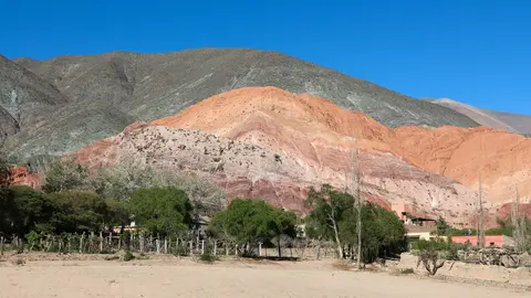
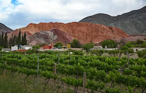
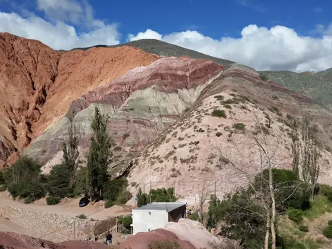
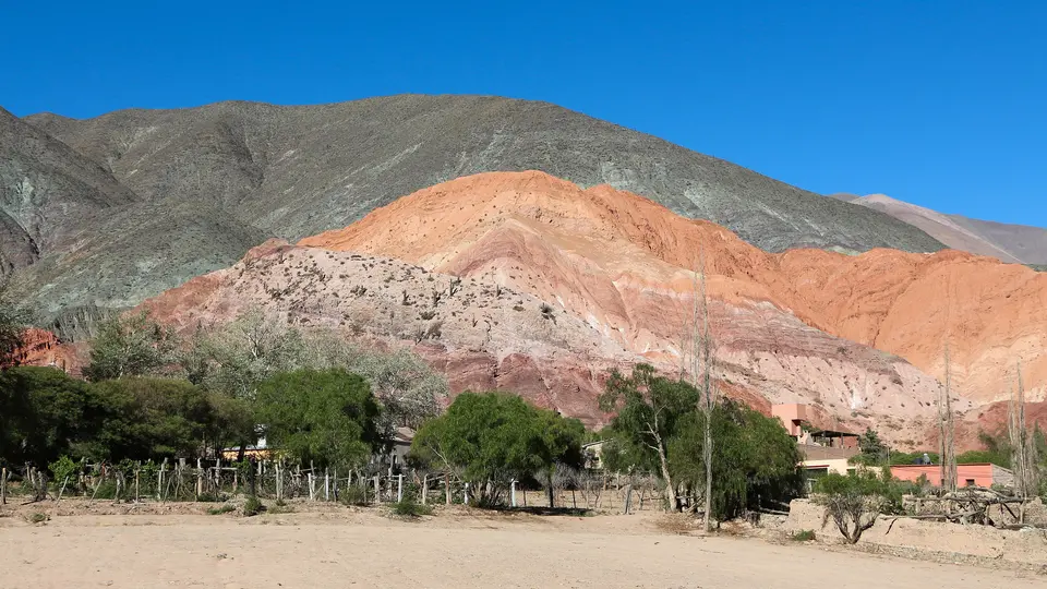
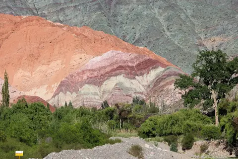
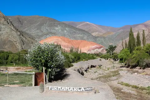
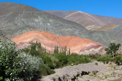
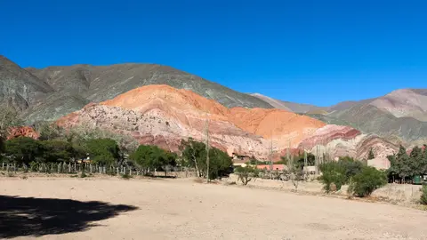
Daily settlement and heritage architecture concentrate in low-rise earthen towns arranged along water tributaries off National Route 9. Along the southern side valley of Quebrada de Purmamarca sits Purmamarca, four kilometres west of Route 9 on Provincial Route 16 and 65 kilometres north of San Salvador de Jujuy (22 kilometres south of Tilcara). Named from the Aymara roots purma (untouched desert land) and marca (town), it faces the folded mineral bands of the Cerro de los Siete Colores (Hill of Seven Colours). The village anchors day treks along the Paseo de los Colorados and Purmamarca River, alongside highland trips to Salinas Grandes salt flats, Huachichocana archaeological site and Laguna de Guayatayoc with its pink flamingos and wild geese.
Purmamarca's central square frames the 1648 Church of Saint Rose of Lima, a National Historic Monument since 1941 set beside a plaza handicraft market. Built with thick mud-plastered adobe walls, a carved entrance lintel, a single narrow nave and a roof framed in cardón cactus wood, it houses 18th-century Cusco School canvases. Every 30 August, its patronal feast features sikuris panpipe ensembles, misachicos processions, erke wind instruments and bombo drums. Historically bypassed by Jujuy's main commercial axis, Purmamarca expanded lodging, tour services and handicraft production after two major shifts. First came completion of the paved Capricorn Axis highway climbing the Cuesta del Lipán toward Paso de Jama and the Pacific coast, followed by UNESCO inscription on 2 July 2003. Nearby excursions lead into the Paseo de los Colorados canyon and along the Purmamarca River bed. Routes also reach the Salinas Grandes salt flats, Huachichocana archaeological site and Laguna de Guayatayoc with its seasonal pink flamingos and wild geese.
Midway up the gorge, Tilcara (home to 6,249 inhabitants at the 2010 census) operates as the corridor's principal trailhead town. It gained national sporting fame in January 1986 when Argentina's football squad held a pre-World Cup altitude training camp there in conditions similar to central Mexico's high plateau. Hikers step straight from earthen town lanes onto canyon tracks, while weavers and ceramicists keep artisan workshops active. Near the northern gateway sits Humahuaca, a historic town of roughly 11,000 inhabitants that gave the entire ravine its name. Historic town centres retain their low-rise colonial layout and Spanish church profiles despite a few over-restored chapels. Outer village peripheries show less architectural unity under modern growth, prompting renewed community revival of traditional earthen masonry and adobe plastering.
Access Zones Through the Quebrada de Humahuaca Valley
Because National Route 9 runs straight up the valley floor, travellers can explore southern Purmamarca, mid-valley Tilcara and northern Humahuaca in sequential stages along the river.
| Complex Zone | Key Highlights | Access & Ticket Rule |
|---|---|---|
| Purmamarca & Side Ravine | Cerro de los Siete Colores, 1648 adobe Church of Saint Rose of Lima, plaza craft market, Paseo de los Colorados trail and Capricorn Axis routes toward Salinas Grandes and Laguna de Guayatayoc | Open village streets and viewpoints; respect parish notices and worship schedules when stepping inside the historic chapel |
| Tilcara & Pucará Fortress | Hilltop Pucará de Tilcara pre-Inca ruins, valley overlooks, mountain footpaths and regional museums 84 kilometres north of Jujuy beside Route 9 | Open-air archaeological complex and museums require entrance tickets checked through Jujuy provincial heritage sources |
| Humahuaca & Northern Gorge | Historic town centre of 11,000 residents, low-rise adobe streets, regional plazas and highland route junctions climbing toward the Puna plateau | Free town circulation; unpaved side-valley tracks toward high tributary settlements often require guided transport or high clearance |
| Coctaca & Protected Archaeological Deposits | 1,500-year-old stone agricultural terraces still in cultivation, plus undisturbed deposits at Los Amarillos and La Huerta | Protected under National Decree 1012/00 and Law 25743/03; surface viewing stays strictly on marked paths without disturbing stonework |
Three Stone, Cactus-Wood, and Geological Details in Quebrada de Humahuaca
- Cardón Cactus Timber Inside Purmamarca's Church: Step beneath the carved entrance lintel of the 1648 Church of Saint Rose of Lima in Purmamarca to examine the ceiling timbers and doors. In a timber-scarce high desert gorge, colonial builders cured the dense woody ribs of native cardón cacti to span the narrow adobe nave, coat rough masonry in smooth mud plaster and frame traditional entrance joinery.
- Mineral Strata on the Cerro de los Siete Colores: View the multi-hued mountain wall behind Purmamarca in crisp morning sunlight. Notice how marine, fluvial and volcanic sedimentary layers tilted upward during Andean uplift, exposing distinct iron, copper and clay bands along eroded ridges.
- Coctaca's Dry-Stone Retaining Walls vs Tilcara Reconstructions: Compare the sweeping 1,500-year-old dry-stone terrace grid still farmed around Coctaca against the taller rebuilt enclosures at Pucará de Tilcara. Spotting the 1940s stone restoration seams at Tilcara helps visitors separate original pre-Inca masonry courses from twentieth-century archaeological reconstruction across the gorge.
Altitude, Summer Rains, and Pairing With Córdoba
Tilcara's cool arid climate (BWk) averages 12 to 14 degrees Celsius annually with a 9.5-degree seasonal range, reaching 30 degrees Celsius average January highs and 4 degrees Celsius average July lows. Virtually all 137 millimetres of yearly rainfall arrives between November and March, turning the dry winter Río Grande riverbed into a vigorous summer flow. April through October brings dry trails, crisp mornings and clear views across canyon strata, Salinas Grandes salt plains and Laguna de Guayatayoc wetlands. Allow gradual acclimatisation around 2,500 metres elevation after landing at Gobernador Horacio Guzmán International Airport (JUJ), 135 kilometres south of Humahuaca. From northwestern Argentina, continue to colonial highland streets in our Córdoba travel guide or browse additional Andean sites in the UNESCO World Heritage Atlas.